Python for GIS Librarians:
Toward a Data Science Core Competency for Geospatial Librarianship
Phil White
Earth Sciences & Environment Librarian
University of Colorado Boulder
WAML San Diego 2018
Phil White, WAML 2018
Title
Text

Phil White, WAML 2018
Overview of Presentation
-
What is Python?
-
Why did I learn it? Why should you?
-
Learning Resources
-
Toward a Data Science Core Competency
Phil White, WAML 2018
Any Python users in the house?
Any R users in the house?
Phil White, WAML 2018
What is Python?
- Programming language
- Free and open source
- Among the most used programming languages in the world
- "There's a Python library for that"
Image: wikimedia
Phil White, WAML 2018
Quick Vocab Lesson
Library: Collection of functions/methods that you can call up without having to write code from scratch.
Numpy: math, stats
xml: working with xml
Pandas: working with tabular data
Requests: calling URLs
API (Application Programming Interface): Method of data exchange.
Script: A series of commands that you run to automate tasks. Python is a scripting language.
Phil White, WAML 2018
Why did I learn Python?
(still learning)
- But in truth, necessity is the mother of invention
- Software Carpentry workshop 2.5 years ago... about 2 hours of Python
- From there, mostly self taught (YouTube! Code Academy)
- About 2-3 months gnashing of teeth, pounding of head, tear drops
Phil White, WAML 2018
Why learn Python?
- Do it for Open Science!
- Cataloging; metadata creation & manipulation...
...but so much more!
- Data reference:
2. Mining, scraping, APIs, downloading
1. Data munging & transformations
- Is code the future of GIS?
- Do it for your students!
Phil White, WAML 2018
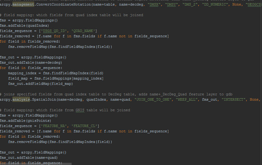
Example 1:
Data that doesn't play nice.
(Massage the data!!)
Phil White, WAML 2018
Why Learn Python?
- Python is the most common language used in GIS
- Built right in to ArcGIS, QGIS
- Automate repetitive geoprocessing tasks
- Free geocoding
- Fast and efficient
- Makes you feel good at your job!
Phil White, WAML 2018
Example 2:
Save hours of work for yourself
(or your heady fwends)
Phil White, WAML 2018
Learning Resources
- Software Carpentry
- W3Schools
- Code Academy
- Your institution?
- Google!
Recommended Installation
Interfaces
Anaconda comes with Jupyter Notebooks!!
Wikimedia
Phil White, WAML 2018
Example 3:
Jupyter Notebooks will help you break through!
(Bonus: Mine data from an API!!)
Phil White, WAML 2018
Resources
GIS Libraries for Python
- ArcPy: Automate ArcGIS tasks
- PyQGIS: Automate QGIS tasks (open source)
- GeoPandas: Adds geospatial operations to Pandas (open)
- Shapely: Geometry (buffer, intersect, union, etc.) (open)
- Rasterio: Raster operations (open)
- GeoPy: Geocoding and distance calculations (open)
- Plotly: Visualization (free(mium))
- So Many Others!!!
Phil White, WAML 2018
Toward a Data Science Core Competency
1. Our patrons are increasingly skilled in tech.
2. GIS Librarians serve a broad community... any discipline!
3. There is so much data out there... if we can just get to it!
4. We should embrace open technologies.
Phil White, WAML 2018
Can you learn Python?
Phil White, WAML 2018
Title
Text

Yes We Can!
obamalibrary.gov
Phil White, WAML 2018
for q in audience:
query = ask(q)
presentation.close()
print ('Thank You')
email = 'philip.white@colorado.edu'
print (email)