GL 13.1 RNAV Approach

Rev 02/2025
Disclaimer
Students should use their textbooks, syllabus, and Airman Certification Standards (ACS) as their primary sources of information. EcFlight is an online training tool designed to simplify and enhance your ground school learning experience. However, it is not a substitute for FAA- or school-approved study materials. Before using these slides for study, always refer to your officially approved resources, such as the Jeppesen physical or electronic book and other FAA-approved materials.
Reference Books
- Pilot's Handbook of Aeronautical Knowledge(FAA-H-8083-25B). (2016). Oklahoma City, OK: United States Department of Transportation, Federal Aviation Administration, Airman Testing Standards Branch.
- Instrument Flying Handbook faa-h-8083-15B. (2012). Oklahoma City, OK: United States Department of Transportation, Federal Aviation Administration, Airman Testing Standards Branch.
- Instrument Pilot Syllabus (10001785-003). (2015). Englewood, CO: Jeppesen.
- Air Traffic Plans and Publications. (n.d.). Retrieved from https://www.faa.gov/air_traffic/publications/
Reference Multimedia
- IFR Enroute Aeronautical Charts and Planning. (2019, March 08). Retrieved from https://www.faa.gov/air_traffic/flight_info/aeronav/digital_products/ifr/
- IFR Enroute Aeronautical Charts and Planning. (2019, March 08). Retrieved from https://www.faa.gov/air_traffic/flight_info/aeronav/digital_products/ifr/
- Antena-Localizer-Aeroparque-2. (n.d.). Retrieved from http://aeromarket.com.ar/noticias/3-aeropuertos-con-nuevas-cartas-de-aproximacion-pbn/attachment/antena-localizer-aeroparque-2/
Reference Multimedia
- Msaviation. (2011, April 12). Retrieved June 10, 2019, from https://www.youtube.com/watch?v=v8OyEWsTi1g
- ILS antenna. (n.d.). Retrieved from http://avineering.com/gp.html
- S. (2018, November 01). Proficiency: Needle work. Retrieved from https://www.aopa.org/news-and-media/all-news/2018/november/pilot/proficiency-needle-work
- Marker beacon system. (n.d.). Retrieved from https://en.ppt-online.org/471683
Index

Approach Design and Equipment
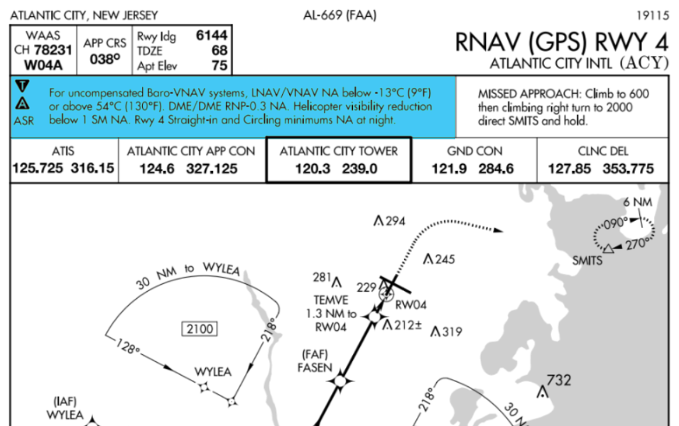
- Approach charts titled “RNAV RWY XX” may be used by aircraft with navigation systems that meet the required navigational performance (RNP) values for each segment of the approach.
- Ground-based NAVAIDs are not required to be operational.
- GPS database must be current and updated.
- RNAV (GPS) approach charts normally have four lines of approach minimums: LPV, LNAV/VNAV, LNAV, and Circling.
- RNAV approaches may contain one or more feeder routes that lead to the Initial Approach Fix (IAF).
- RNAV (GPS) with WAAS will provide LPV or LNAV/VNAV minimums.
- RNAV (GPS) without WAAS will provide only Lateral navigation (LNAV) minimums.
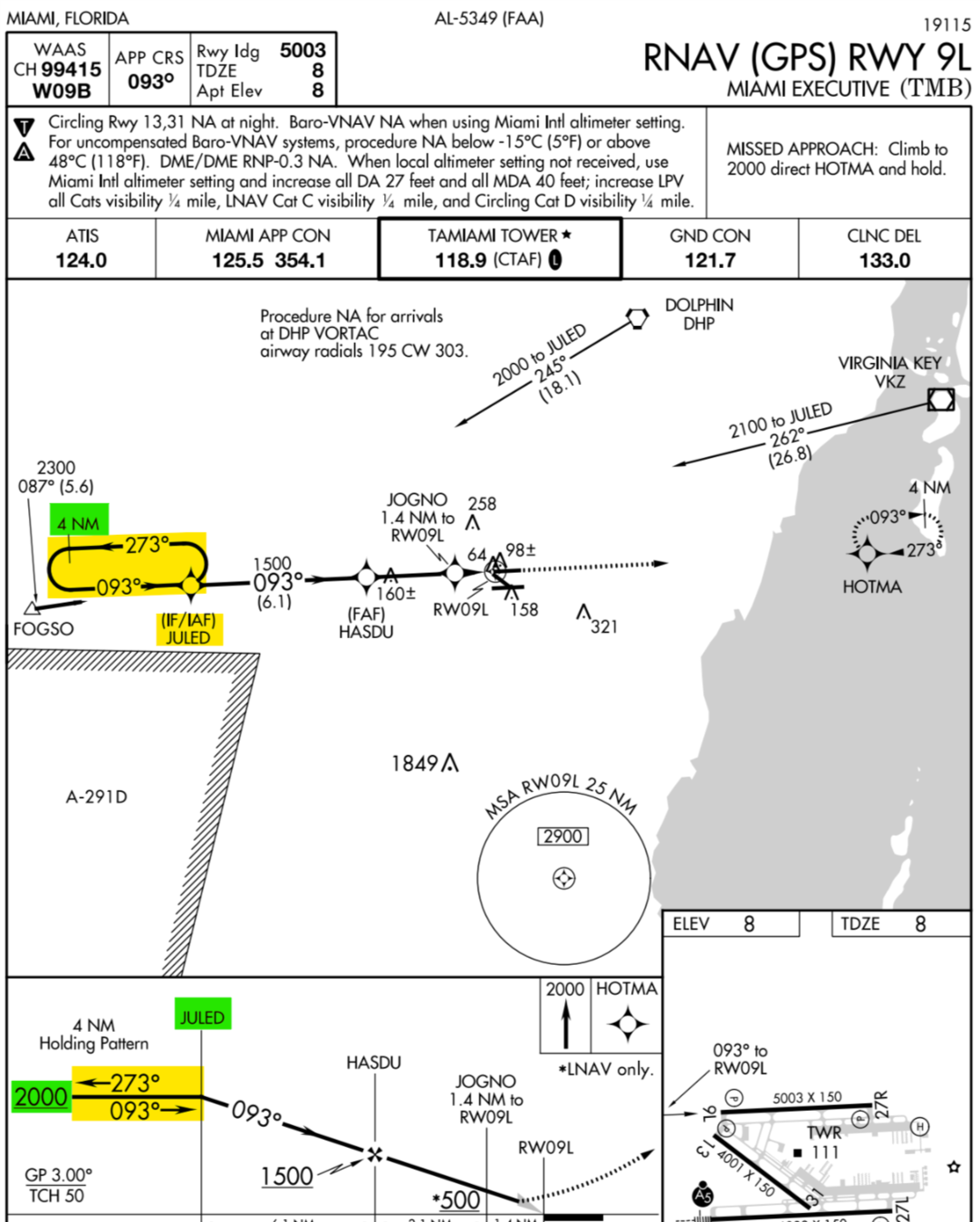
Terminal Arrival Area
- The objective of the TAA is to provide a seamless transition from the en route structure to the terminal environment.
- The TAA provides the pilot and air traffic controller with a very efficient method for routing traffic into the terminal environment.
- The chart shows a T basic method configuration.
Waypoints
The database indicates whether waypoints are Fly-by waypoint and Fly-over point
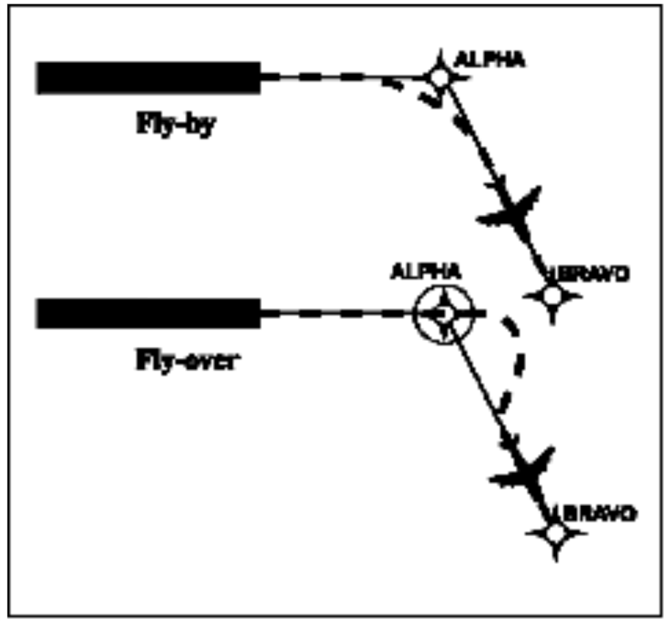
Fly-by waypoint
Fly-over waypoint
GPS Approach Equipment
- GPS must also be certified for instrument approaches according to TSO-C129 or TSO-C196.
- GPS can provide Vertical navigation if equipped with a Baro-VNAV or WAAS GPS (TSO-C145 or C146).
BARO-VNAV
- Baro-VNAV is an RNAV system function that uses barometric altitude information from the aircraft’s altimeter to compute and present a vertical guidance path to the pilot.
- Baro-VNAV provides LNAV/VNAV minimums but will NOT authorize the pilot to perform LPV minimums.

BARO-VNAV
- Baro-VNAV is not authorized without the local altimeter setting.
- It compensates for freezing temperatures and limitations will be published in the note section of the specific approach.
WAAS Certified GPS
- Provides lateral and vertical guidance.
- Eliminates barometric error and is not limited to temperature conditions.
- Airplanes equipped with Non-WAAS GPS must be equipped with alternate avionics necessary for ground-based facilities.
- Alternate airports must
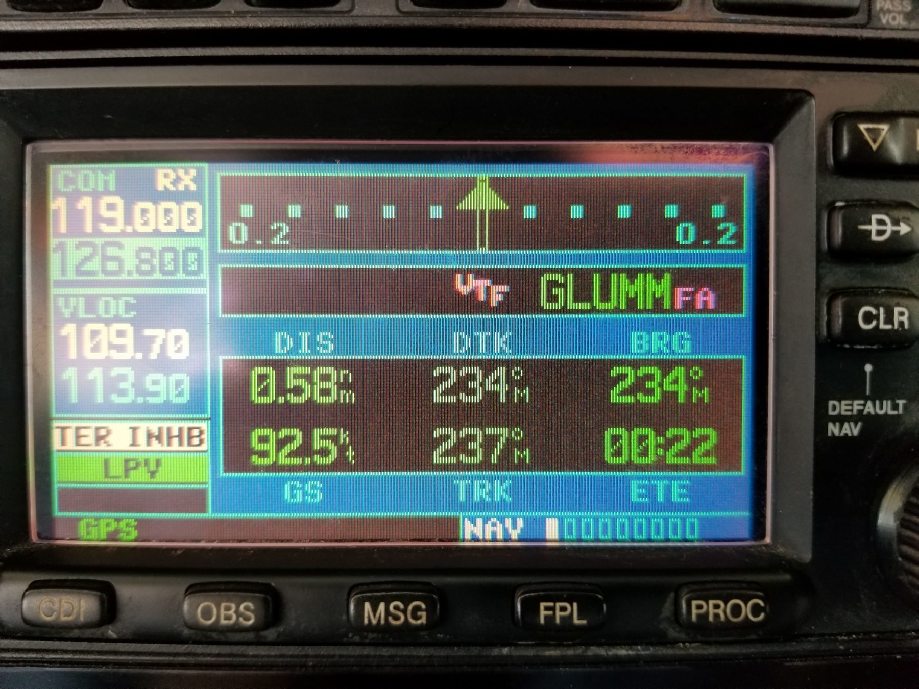
WAAS channel and approach identifier
Approach ID consists of the W letter and additionally, two number specific to the runway.
Landing Minimums
The GPS receiver only displays the approach procedures available for the approach.
LNAV
- The procedure is based on lateral guidance only.
- TSO C129 or TSO C196 are required.
- MDA minimums are considered.
- Descent to the MDA 600 ft, check for runway environment. if not insight, continue until crossing the missed approach fixed (MAP).
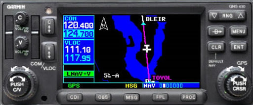
- At some airports, the FAA isn't able to design LPV or LNAV/VNAV approaches because of terrain and obstacles. If that occurs, LNAV minimums will apply. But when they can, the FAA adds "advisory vertical guidance," which you see on a WAAS-capable GPS system as "LNAV+V".
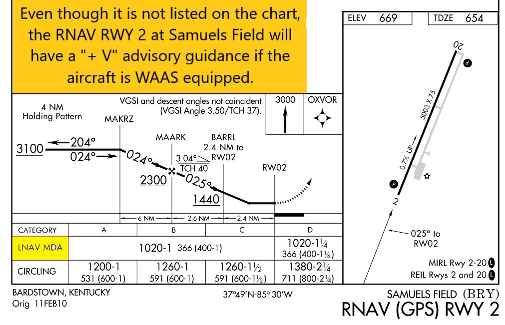
LNAV+V
- You won't see the "+V" listed on a chart, but you will see it listed on your GPS unit's display when you load the approach. .When you fly an LNAV +V approach, you need to use LNAV minimums, but the +V will give you an advisory glide path all the way down the approach.
LNAV/VNAV
- WAAS or Baro-VNAV certified unit is required. On WAAS certified units, when LPV and LNAV/VNAV minimums are an option, the GPS will always give you LPV (since it is the lowest possible minimum).
- Integrity limits for LNAV/VNAV are larger than those for a precision approach. However, they still provide lateral and vertical guidance, so a DA (Decision Altitude) is shown on the plate.
LPV
- Localizer performance with vertical guidance (LPV) minimums is also provided for RNAV (GPS) approach procedures with decision altitude (DA), not an MDA altitude.
- Your GPS equipment must be WAAS-certified to fly approaches to LPV minimums.

LP
- Localizer Performance (LP) minimums are commonly referred to as WAAS procedures without vertical guidance, but they are still non-precision approach minimums with an MDA.
- Baro-VNAV equipment will not be capable of being used to fly approaches to LP minimums; only WAAS-certified users can use this line of minimums.
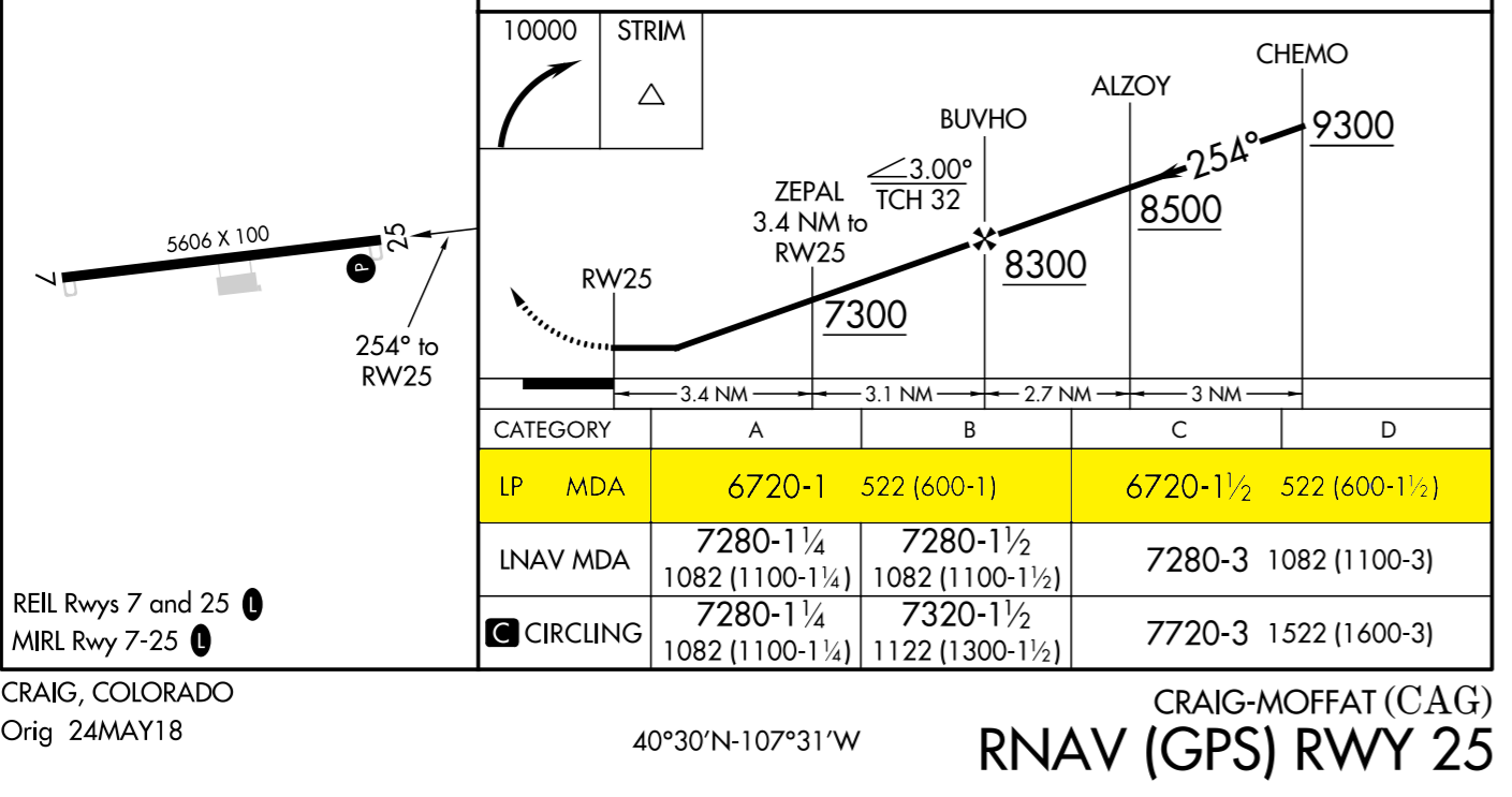
- Verify the type of approach the GPS unit will display within 2NM before the final approach fix
RNP Approach
- To perform RNP approaches, you and your aircraft must meet SAAR (Special Aircraft and Aircrew Authorization Required) performance criteria.
-
RNP is similar to RNAV, with one major difference: RNP requires precise on-board performance monitoring to tell you if your navigation isn't as accurate as it should be. What does the monitoring? On many aircraft, the FMS (Flight Management System) does. Some instrument approaches require accuracy as small as 0.1 RNP, or 0.1 nautical miles.
Example
RAIM Failure During an Approach
GPS will calculate RAIM prediction at least two nautical miles prior to the final approach fix to ensure RAIM availability before it enters approach mode.
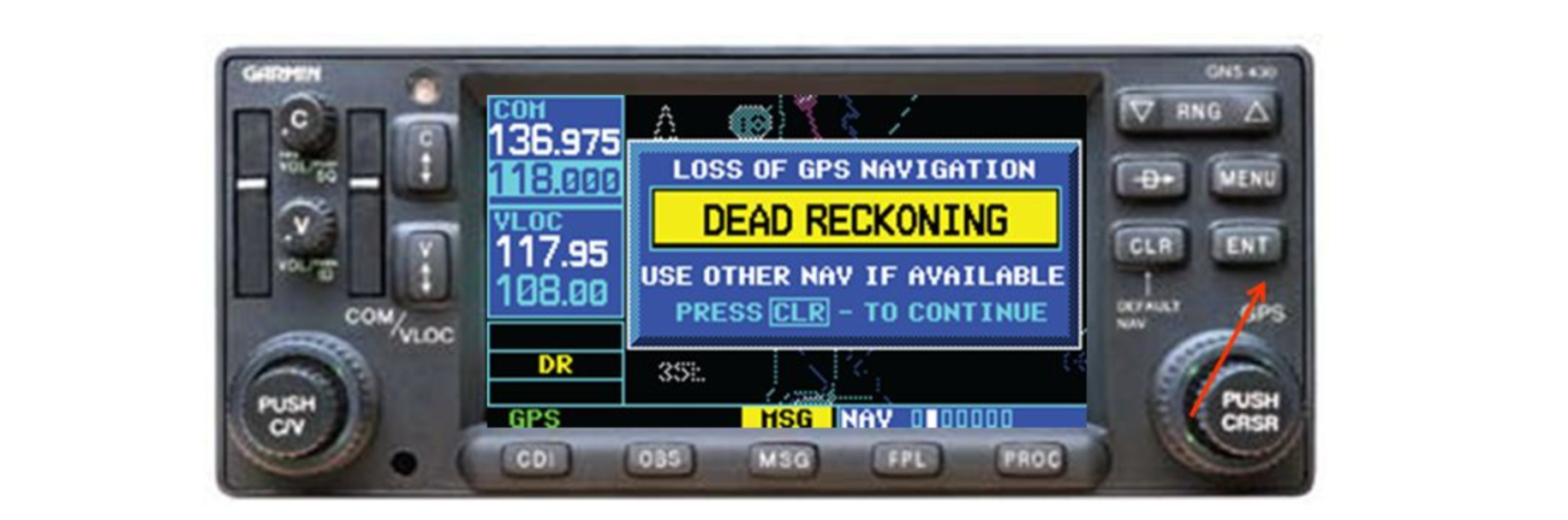
Raim Failure prior to the Final Approach Fix(FAF)
Raim Failure after Final Approach Fix(FAF)
Execute a missed approach and advise ATC as soon as possible.
GPS receiver continues to operate without a failure indication for up to five minutes so you can complete the approach.
If you do notice a RAIM failure indication regardless of the position of the aircraft during the approach execute a missed approach.
Flying an RNAV (GPS) Approach
- Make sure that your airplane is equipped with the proper GPS navigation to perform the approach.
- Brief the approach and pay attention to the details of the approach procedure.
- IFR-certified GPS installed in your aircraft, which gets updated every 28 days.
Flying an RNAV (GPS) Approach to LPV Minimums
- LPV approach minimums are for WAAS-equipped aircraft only
- You can fly the approach to its lowest minimums (DA) due to WAAS ability that's correcting itself to a more precise location.
- Situational awareness
- Interpreting the approach chart
- Determining the appropriate approach minimums.
- Accurately Programming the GPS unit.
Essential skills to perform a GPS approach
Preparing for the Approach
- The Approach overview is the initial review of the expected approach procedure.
- Determine the factors that will affect the ability to perform the approach ahead of time.
- Landing minimums, terrain, obstacles, and specific equipment are elements you should include.
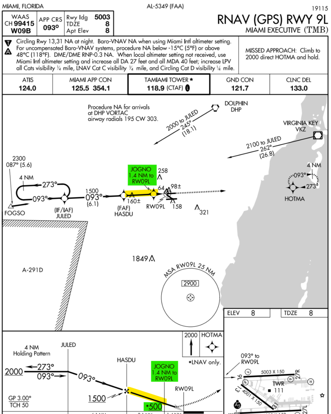
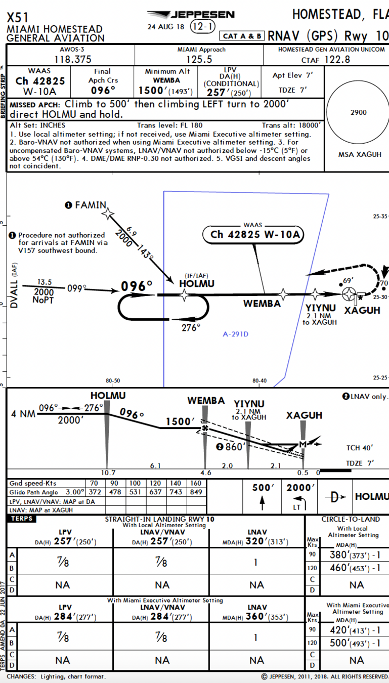
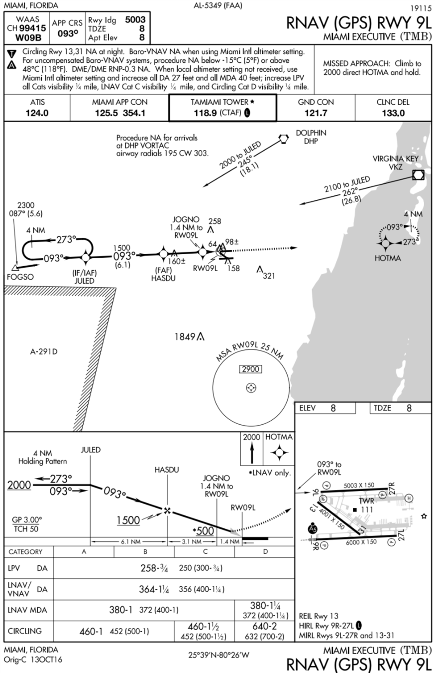
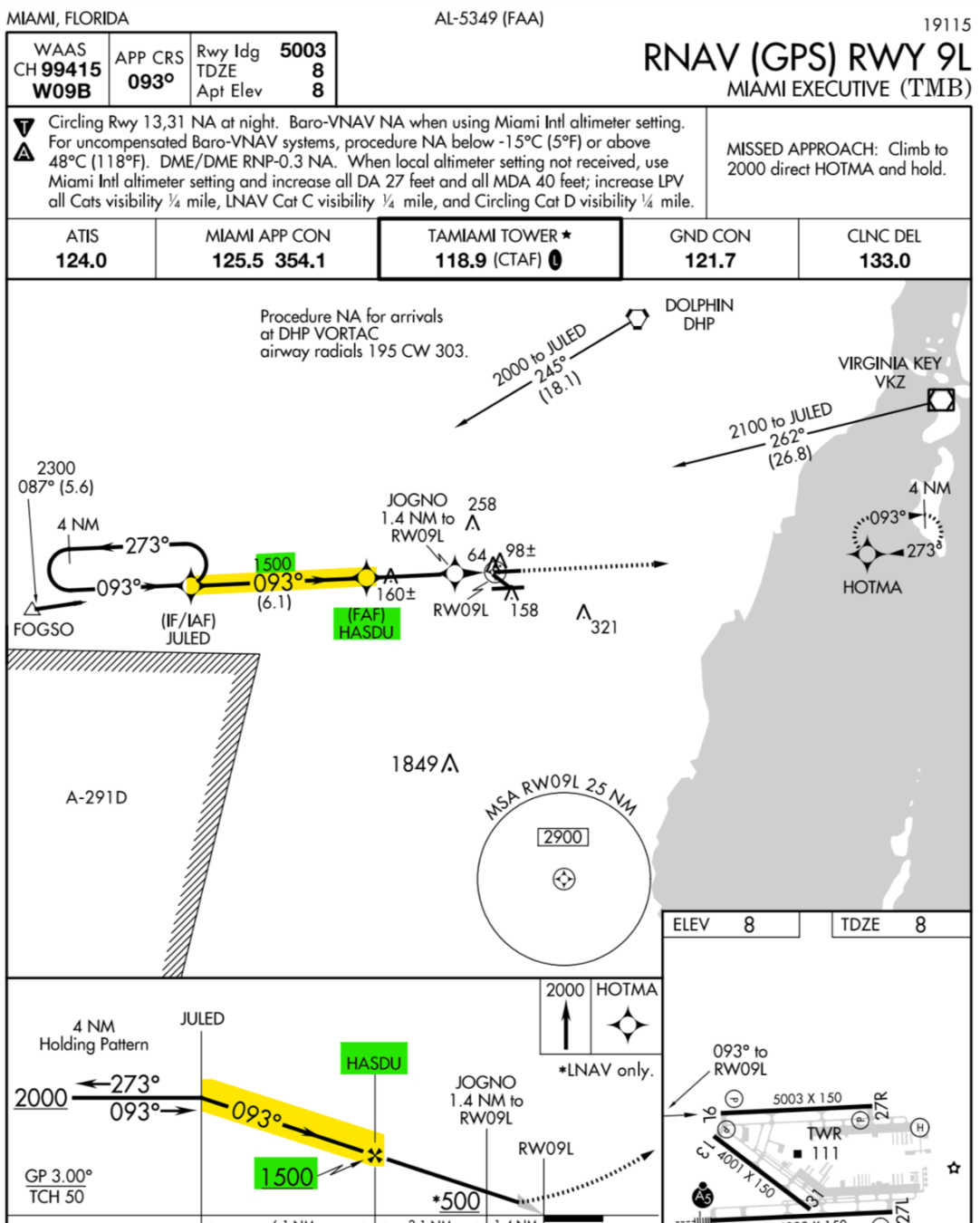
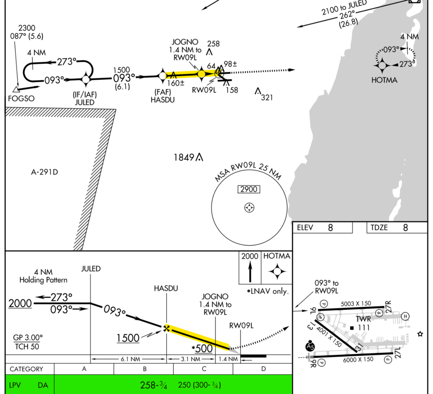
Approach Overview
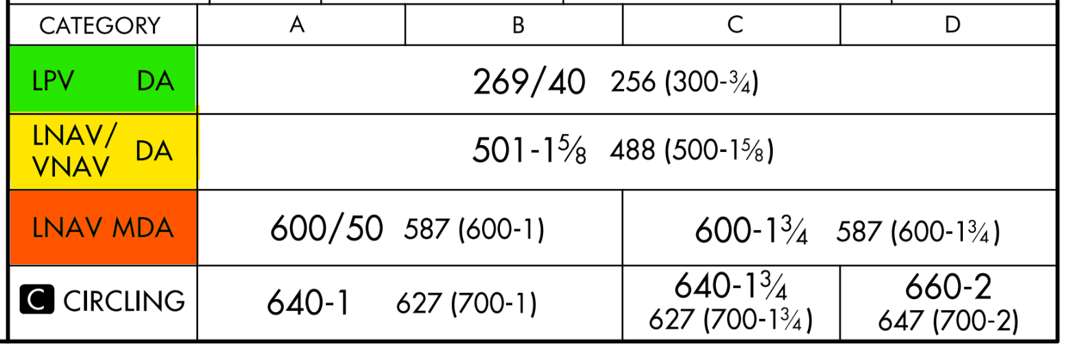
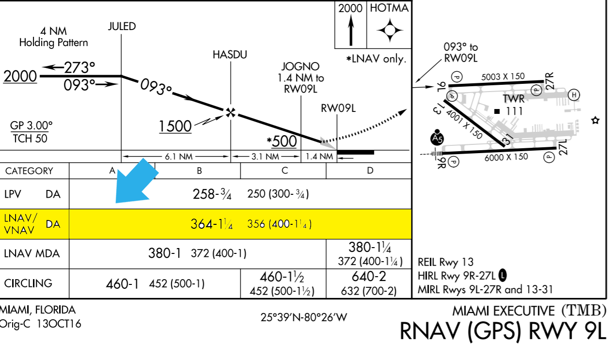
Landing Minimums
- Required visibility for the approach is 4,000 feet.
- DA of 269 feet MSL.
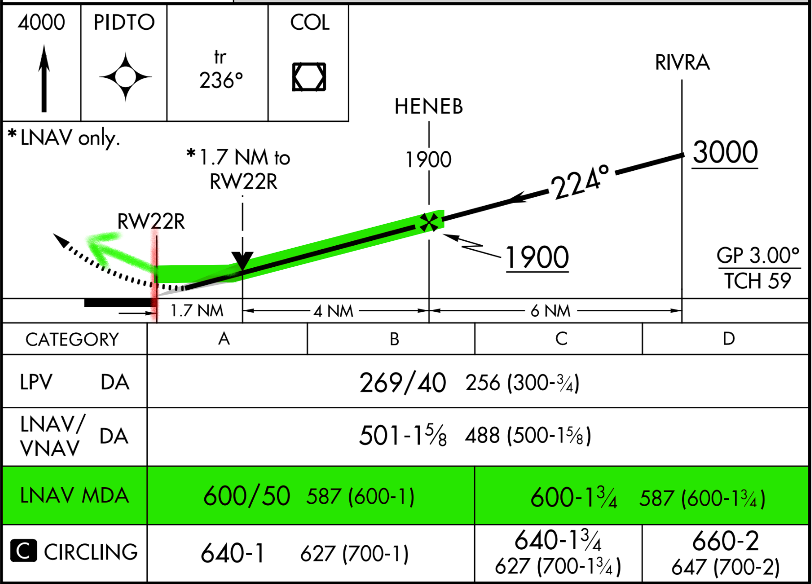
Procedures Features
- The approach uses a TAA to transition the aircraft from the enroute to the approach fix.
- Check for note applicable to the approach.
- Type of RNAV approach and requirements.
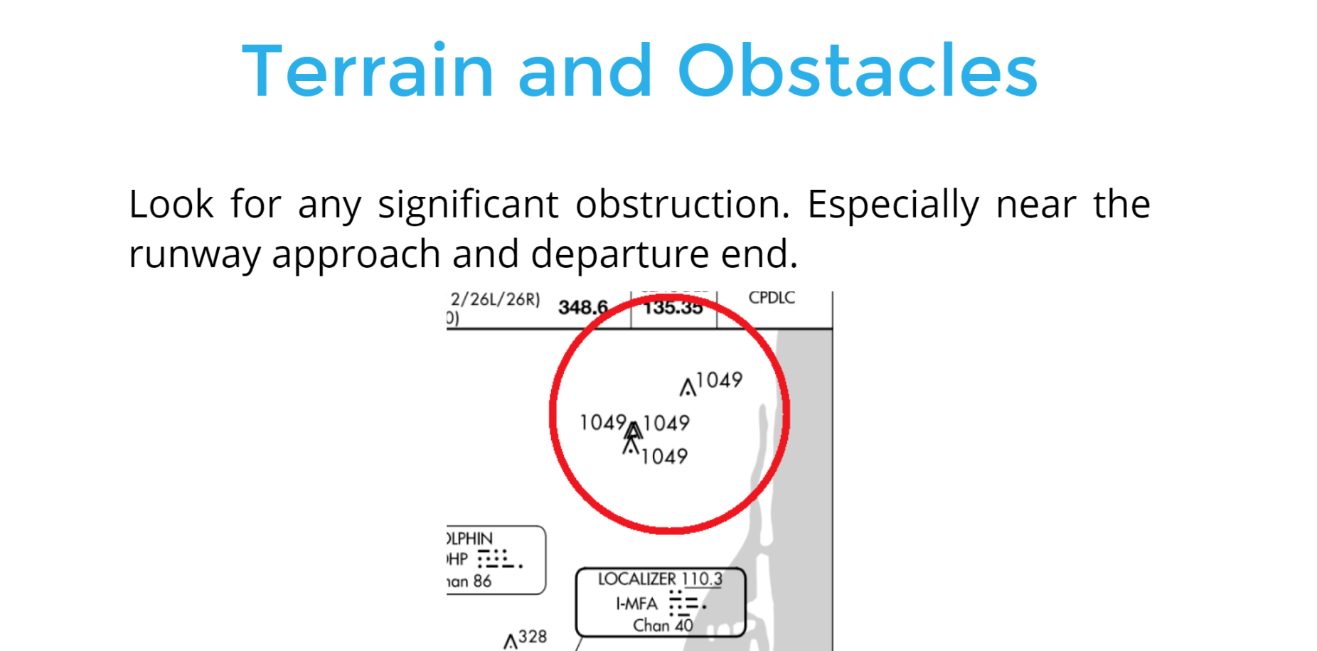
1) Terrain and Obstacles
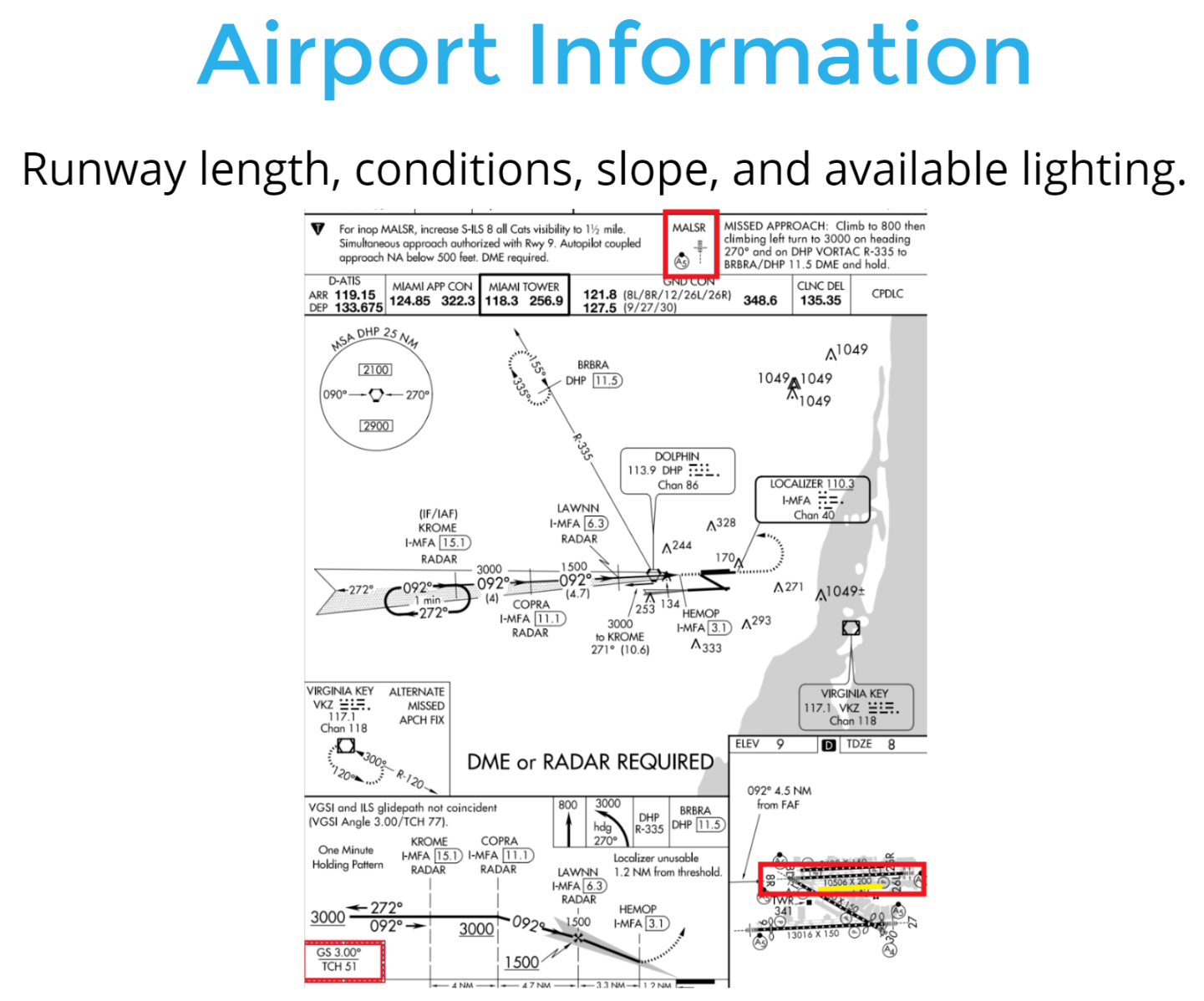
2) Airport Information
- During the approach briefing:
- Load the approach procedure on the GPS receiver.
- Verify that the waypoints and transition names coincide with names on the approach chart and are spelled the same.
Approach Briefing
Voice By: John Duque
Performing The Approach
Airplane Demonstration
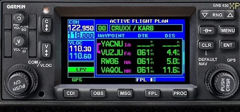
Make sure the GPS Mode is ON
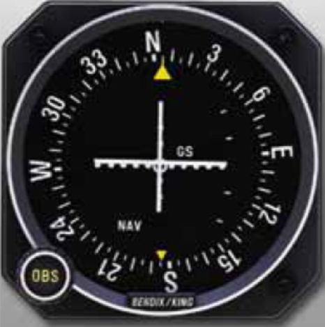
Primary navigation instrument is the HSI, display the moving map or backup CDI on the receiver.
Approach Clearance
ATC can assign you a direct route to a GPS fix.
For example: "N123EC cleared direct JULED".
With that clearance, activate the approach on the GPS receiver and select Direct JULED.
Demo GPS Equipment
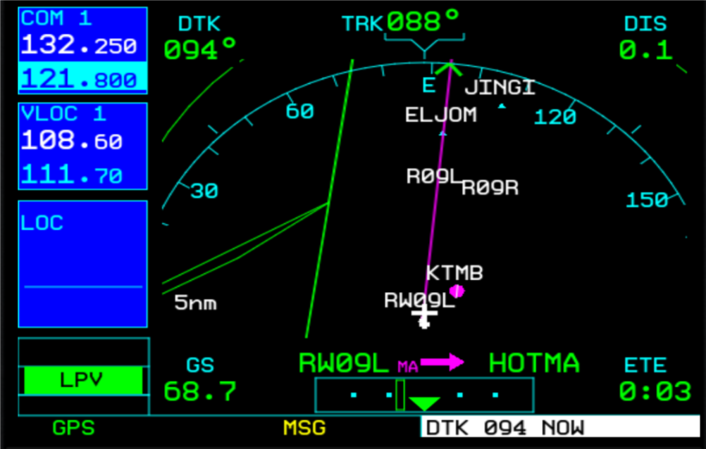
ATC can also assign you a heading to intercept the Final Approach Course.
For example: "N123EC fly heading 060° until established on the final approach course. Cleared RNAV 9L approach Tamiami.
With that clearance, activate the approach on the GPS receiver on Vectors to final.
Demo GPS Equipment
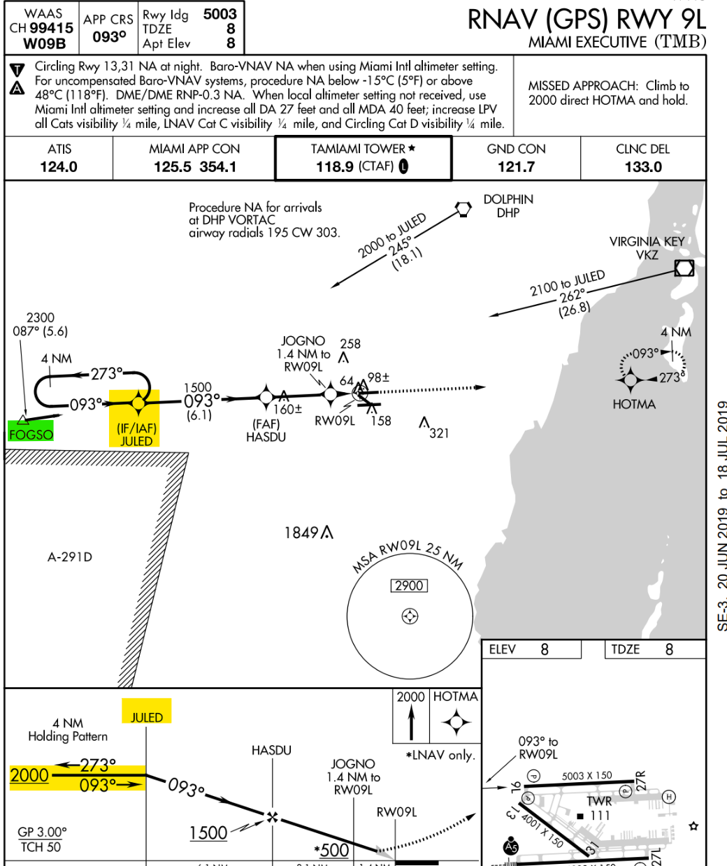
Approach Segments
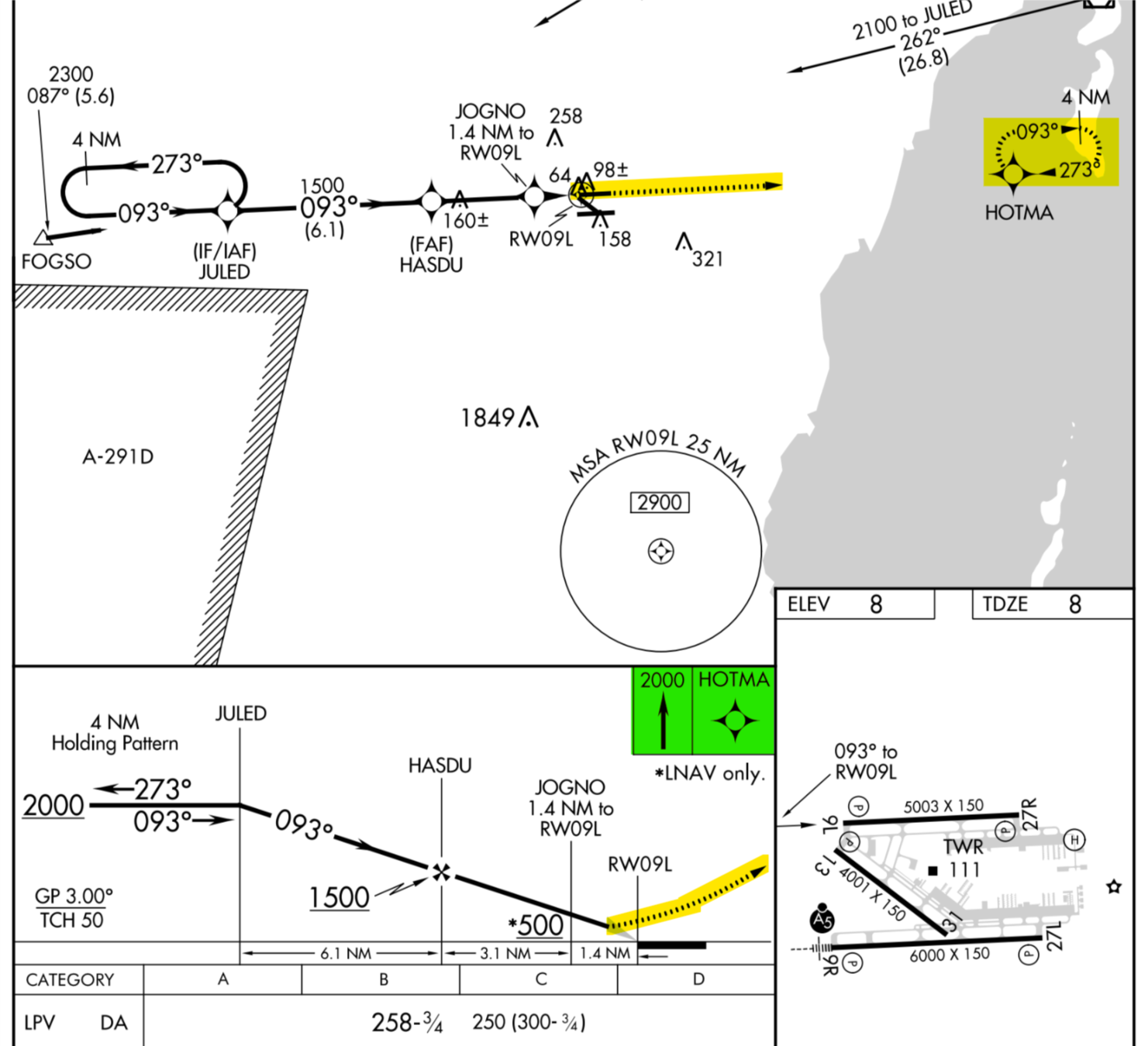
Reference approach:
RNAV 9L (Miami Executive) KTMB.
Initial Approach Segment
Execute the procedure turn to intercept the final approach course at or above 2,000 Feet.
Intermediate Approach Segment
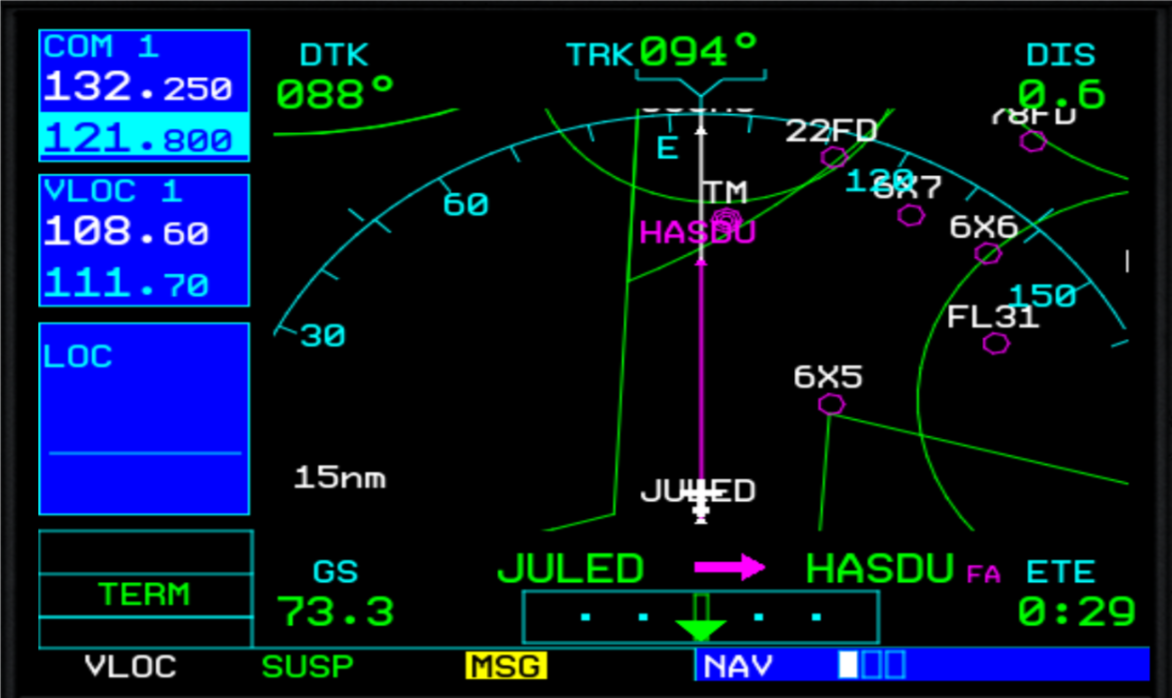
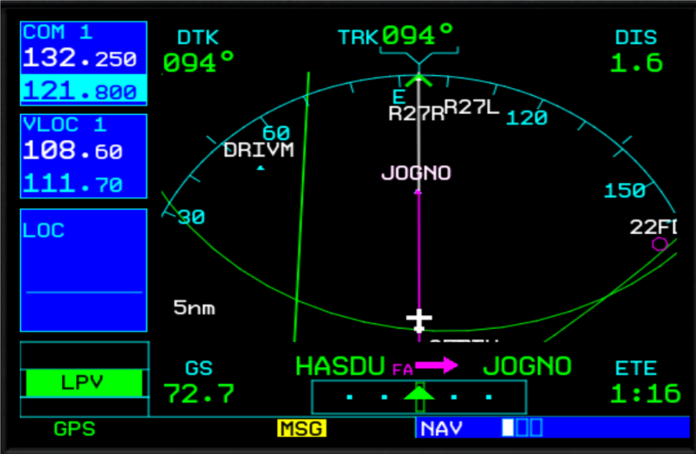
Demo GPS Equipment
- After crossing JULED execute the Descent to 1.500 feet at an airspeed of 90kts until HASDU.
- Execute the pre-landing checklist and configure the airplane for the approach.
- Expect to contact tower before crossing the FAF.
Final Approach Segment
Demo GPS Equipment
After the glide slope has been intercepted at HASDU (FAF) at 1.500 feet.
Descent to the LPV minimums of 258 ft MSL.
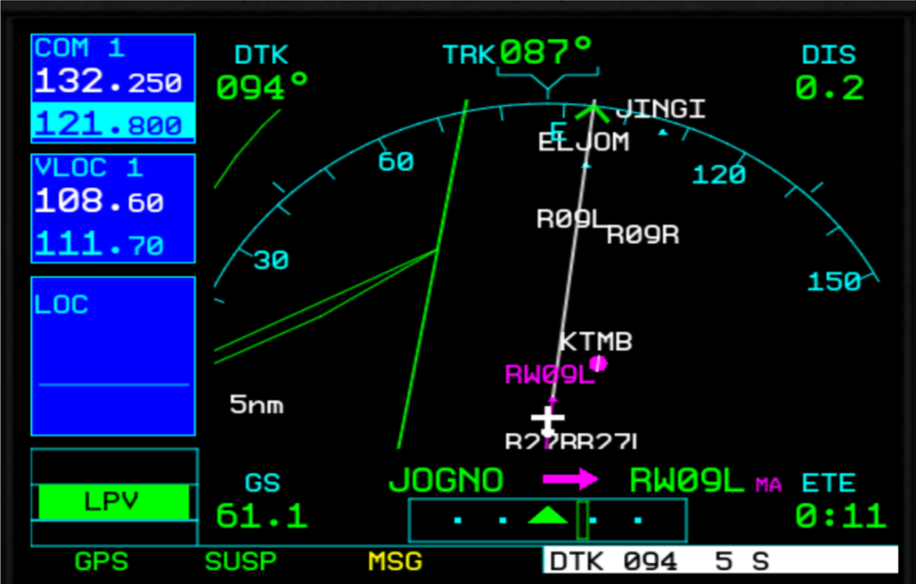
Missed Approach Segment
Demo GPS Equipment
After reaching the DA, execute a missed approach but do not turn until crossing the Missed approach point (RWY 9l).
Press the SUSP softkey on the GPS to activate the missed approach procedure.
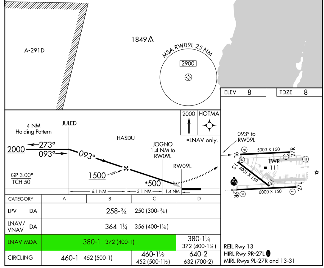
Flying an RNAV (GPS) Approach to LNAV Minimums
If the aircraft do not have baro-VNAV equipment or a WAAS-certified GPS, you must fly the approach to LNAV minimums without vertical guidance.
-
The final approach fix, the procedure changes. You are now flying an approach to an MDA without vertical guidance.
-
Identify each step-down fix throughout the approach.
- Upon reaching the missed approach point (MAP), execute the missed approach procedure.