GL 5 The Flight Environment

Rev 01/2025
Disclaimer
Students should use their textbooks, syllabus, and Airman Certification Standards (ACS) as their primary sources of information. EcFlight is an online training tool designed to simplify and enhance your ground school learning experience. However, it is not a substitute for FAA- or school-approved study materials. Before using these slides for study, always refer to your officially approved resources, such as the Jeppesen physical or electronic book and other FAA-approved materials.
Reference Books
- Pilot's Handbook of Aeronautical Knowledge(FAA-H-8083-25B). (2016). Oklahoma City, OK: United States Department of Transportation, Federal Aviation Administration, Airman Testing Standards Branch.
- Instrument Flying Handbook faa-h-8083-15B. (2012). Oklahoma City, OK: United States Department of Transportation, Federal Aviation Administration, Airman Testing Standards Branch.
- Instrument Pilot Syllabus (10001785-003). (2015). Englewood, CO: Jeppesen
- Cessna. (1976). Pilot's Operating Handbook(D1057-13). Wichita, KA: Cessna.
- Jeppesen. (2019). Instrument/Commercial textbook: Jeppesen instrument rating and commercial pilot certificate textbook.
- https://www.faa.gov/air_traffic/flight_info/aeronav/productcatalog/IFRCharts/
- https://www.faa.gov/about/initiatives/notam/what_is_a_nota
- https://www.faa.gov/about/office_org/headquarters_offices/ato/service_units/systemops/fs/alaskan/alaska/fai/notam/ntm_overview
Reference Multimedia
- Pilot's Handbook of Aeronautical Knowledge(FAA-H-8083-25B). (2016). Oklahoma City, OK: United States Department of Transportation, Federal Aviation Administration, Airman Testing Standards Branch.
- Instrument Flying Handbook faa-h-8083-15B. (2012). Oklahoma City, OK: United States Department of Transportation, Federal Aviation Administration, Airman Testing Standards Branch.
- Instrument Pilot Syllabus (10001785-003). (2015). Englewood, CO: Jeppesen
- Cessna. (1976). Pilot's Operating Handbook(D1057-13). Wichita, KA: Cessna.
- http://learntoflyblog.com/wp-content/uploads/2017/02/22-1.jpg
- https://skyvector.com/files/tpp/2302/afdpdf/SE_160_23FEB2023.pdf
- Jeppesen. (2019). Instrument/Commercial textbook: Jeppesen instrument rating and commercial pilot certificate textbook. pg.3-15
- https://149355317.v2.pressablecdn.com/wp-content/uploads/2019/03/fly-drone-washington-dc.jpg
- https://m.media-amazon.com/images/W/IMAGERENDERING_521856-T1/images/I/61AkG5EyQ2L._AC_UF1000,1000_QL80_.jpg
- https://1.bp.blogspot.com/-pWXaZmJRXAc/YKnx8T3pvEI/AAAAAAAACUE/51UxagsNZxQZxHxz1wgoTK9Zf6-NasK3wCNcBGAsYHQ/s1124/16-1-min.png
- https://news.jeppesen.com/wp-content/uploads/2018/01/static1.squarespace-18.jpg
- https://skyvector.com/files/tpp/2302/afdpdf/SE_111_23FEB2023.pdf
- https://s3.amazonaws.com/marquee-test-akiaisur2rgicbmpehea/jpWICGwQ1yb84Z86Lya7_BA_cockpit-double-chrome%20%282%29.jpeg
Reference Videos/Animations
ERAUSpecialVFR. (n.d.). Motion picture.
https://slideplayer.com/slide/12832059/
Index

The
Airport Environment
This chapter examines airport operations, identifies features of an airport complex, and provides information on operating inside airspace. this is an important aspect during IFR operations.
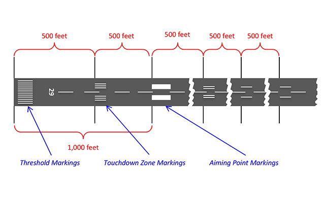
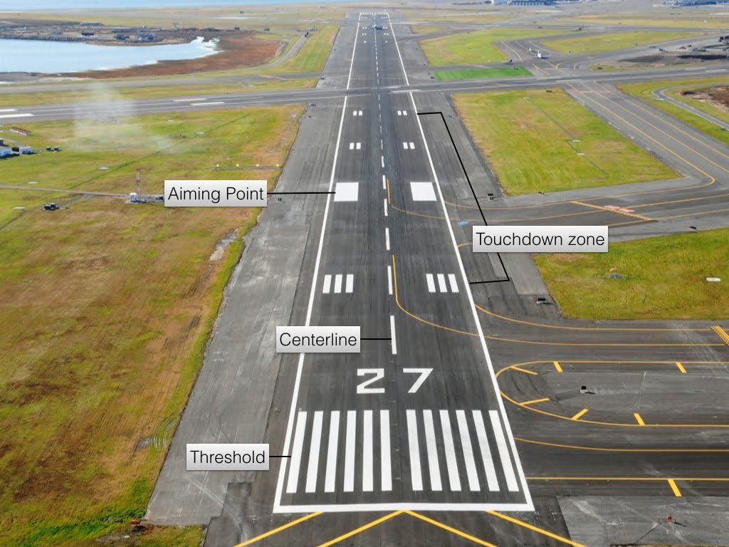
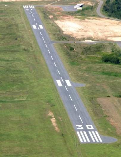
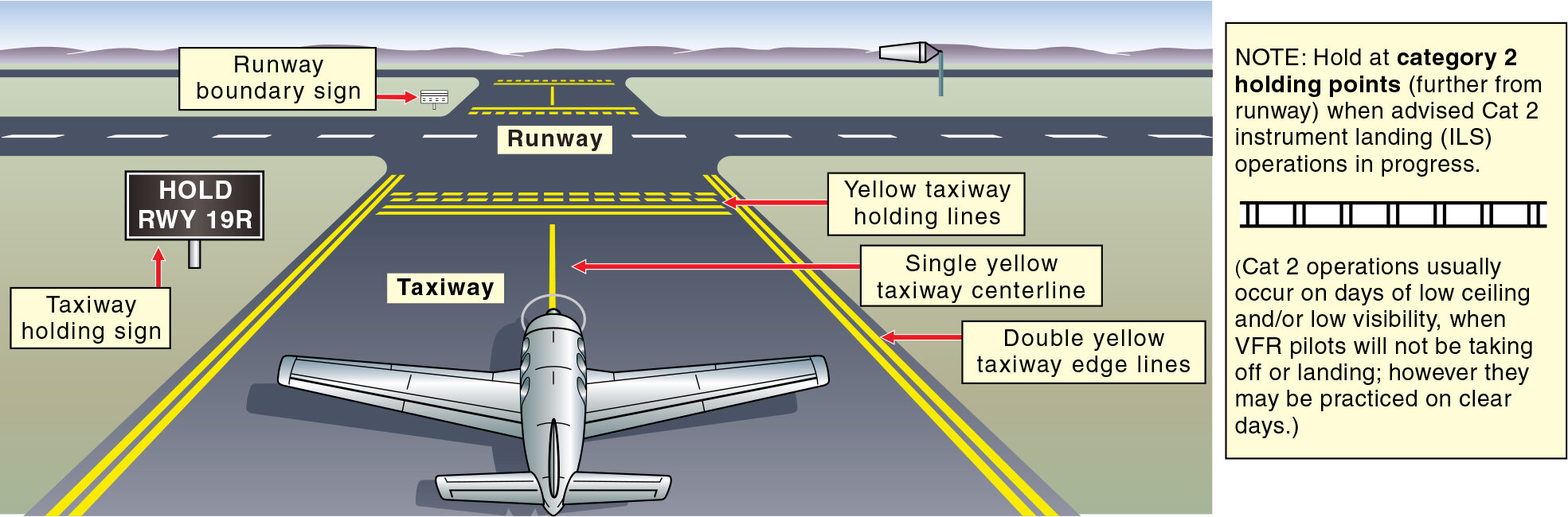
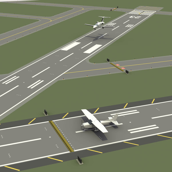
Runway And Taxiway Markings and Signs
Runways markings
Nonprecision Instrument
Visual
Precision Instrument
Precision Instrument
Non-Precision Instrument
1,000 Feet
Visual
Taxiway Markings
- Taxiways have a letter designation to be identified.
- They are easy to identify by continuous yellow center stripes.
- The link between the airport parking areas and the runways are the taxiways.
click here
Hold Short Line
-
NEVER cross the solid side of a Hold Short Line unless you are cleared for takeoff or are ABSOLUTELY SURE that you have permission to cross!
-
If you are not sure if you are cleared to cross a runway, ASK!
Additional Markings
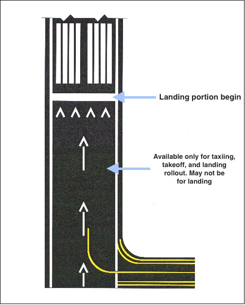
Used to Taxing and Takeoff, but NOT for landing
Displaced Threshold
Blast Pads
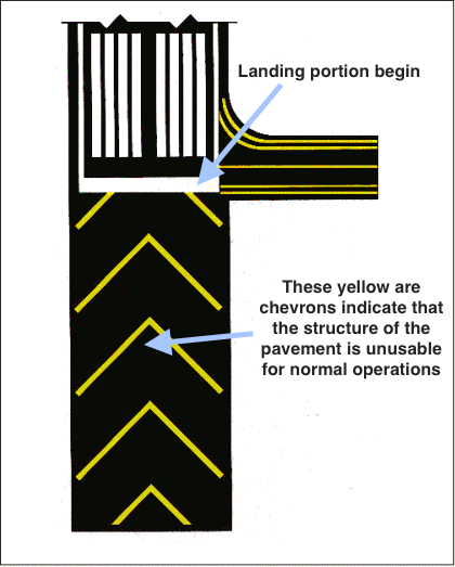
Can not be used for taxi, takeoff or landing
Closed Runways
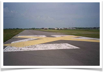
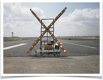
- Temporarily Closed: Yellow X’s are placed at each approach end of the runway. Temporary X’s may be lighted
- Permanently Closed: Yellow X’s are placed at each approach end of the runway and at every 1000 ft. interval. Threshold markings are obliterated.
Airport Signs
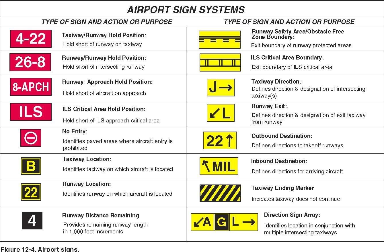
Airport Visual Aids
The airport environment can seem confusing. However, just as you learn how to interpret traffic signals, road signs and highway making, you will soon become familiar with visual aids at an airport.
Non-Movement Area
Where the airport parking area is located. Also known as Non-Movement Area
Inside the Non-Movement Areas Pilot can move without ATC clearance
Movement Areas are Taxi ways and Runways. Pilots needs ATC clearance move the airplane.
Movement Area
Ramp Area/Hand Signals
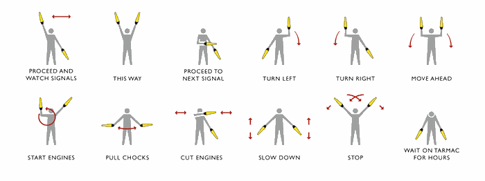
As a pilot, you need to be familiar with signals provided to park the airplane.
Runway Incursion Avoidance
A runway incursion is “any occurrence in the airport runway environment involving an aircraft, vehicle, person, or object on the ground that creates a collision hazard or results in a loss of required separation with an aircraft taking off, intending to take off, landing, or intending to land.”
Prevent a Runway Incursion
Proper planning can prevent runway incursions and the possibility of a ground collision. A pilot should be aware of the aircraft’s position on the surface at all times and be aware of other aircraft and vehicle operations on the airport.
- Read back all runway crossing and/or hold instructions
- Review airport layouts as part of preflight planning, before descending to land and while taxiing, as needed.
- Know airport signage.
- Review NOTAM for information on runway/taxiway closures and construction areas.
- Request progressive taxi instructions from A TC when unsure of the taxi route.
The following are some practices to help prevent a runway incursion:
- Check for traffic before crossing any runway hold line and before entering a taxiway.
- Turn on aircraft lights and the rotating beacon or strobe lights while taxing.
- When landing, clear the active runway as soon as possible, then wait for taxi instructions before further movement.
- Study and use proper phraseology in order to understand and respond to ground control instructions.
- Write down complex taxi instructions at all times
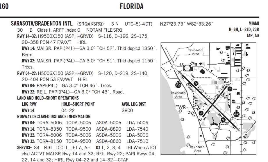
Land and Hold Short Operations
(LAHSO)
- Is an ATC tool used to increase airport capacity, and maintain system efficiency.
- You must complete specific knowledge-based training before participating in LAHSO.
- In addition, solo student pilots are not authorized to participate in LAHSO.
Pilot Responsibility
Text
- Only accept LAHSO clearance if you have determined that your aircraft can land safely and stop within the available landing distance (ALD).
- If you have the slightest doubt, you decide to decline the clearance.
- LAHSO clearance only when the visibility is at least 3 SM and 1,000 ft of ceiling.
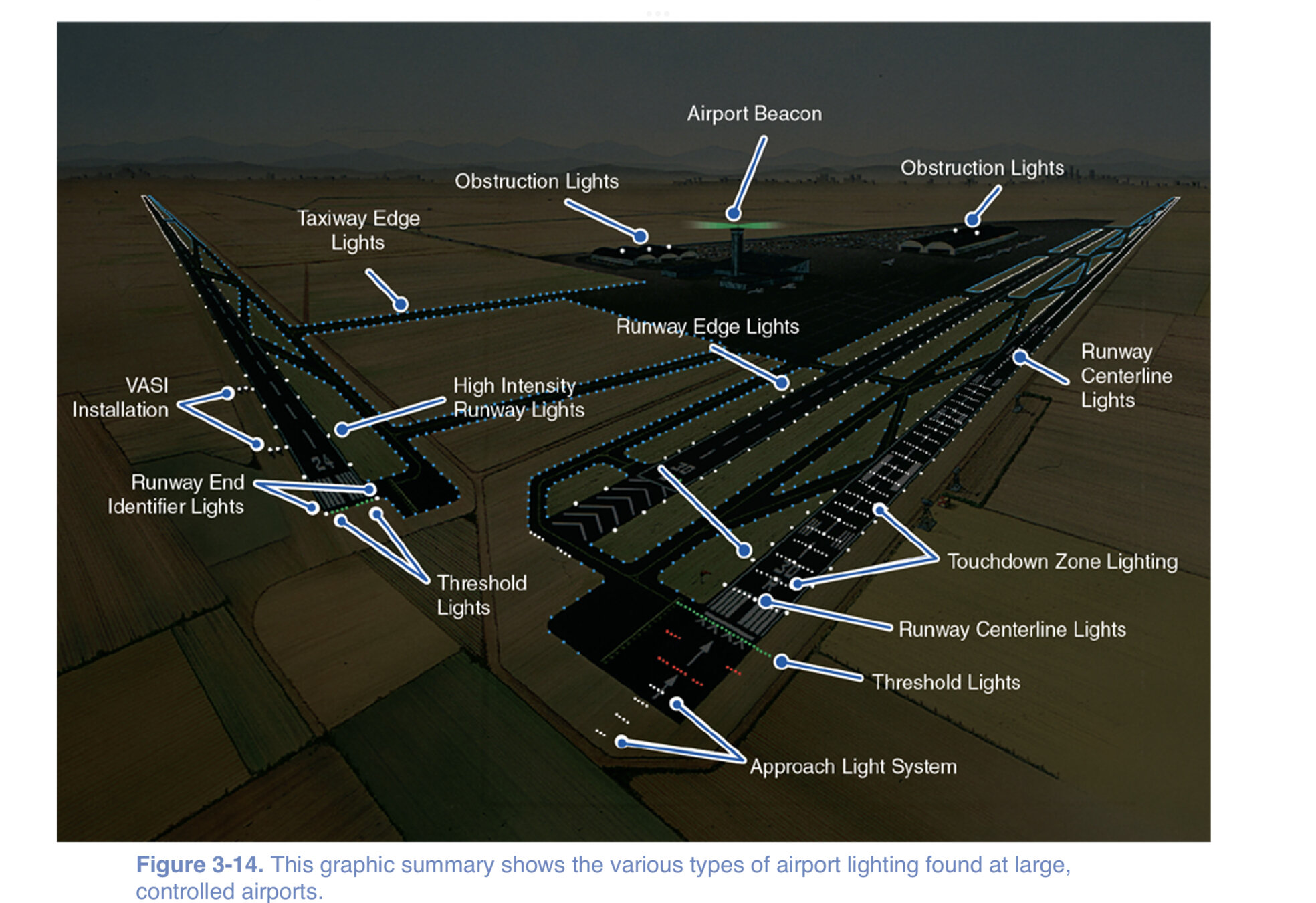
Approach Light Systems
-
Help instrument pilots transition to visual references at the completion of an instrument approach.
- Extend 2,400 to 3,000 ft from precision instrument runways.
- Extend 1,400 to 1,500 ft from nonprecision runways.
Systems Include
- Sequence flashing lights (SFL)
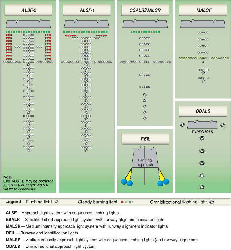
- Runway Alignment Indicator Lights (RAIL)
Visual Glideslope Indicators
-
They are light systems which indicate your position in relation to the desired glide path to the runway.
- Located on the side of the runway.
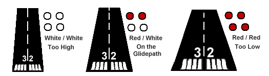
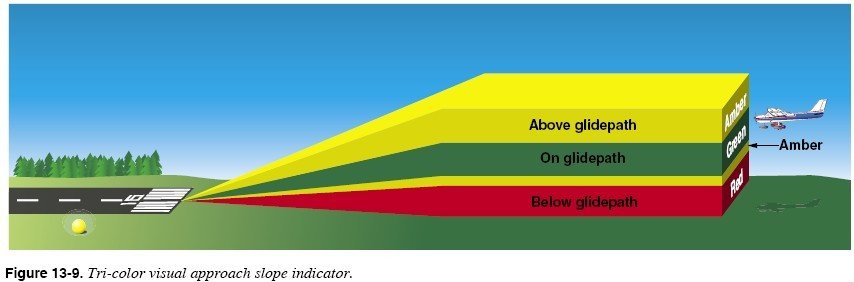
Visual approach slope indicator (VASI)
-
Two-bar systems have near and far bars.
-
Provides obstacle clearance within 4NM of the runway threshold within 10º of centerline.
-
A tri-color VASI uses a single light unit to project a three-color visual path.
Precision Approach Path Indicator (PAPI)
-
It has two to four lights installed in a single row instead of a far and near bars.
-
The PAPI is normally located on the left side of the runway and can be seen up to 5 miles during the day and 20 miles at night.
Runway Lighting
-
Classified according to three intensity levels. High-intensity runway lights (HIRLS) are the brightest runway lights available. Medium intensity runway lights (MIRLS) and low-intensity runway lights (LIRLS) are, as their names indicate, dimmer in intensity.
-
Consist of a single row of white lights bordering each side of the runway and lights identifying the runway threshold.
2,000feet remaining
Taxiway Lighting
-
As you taxi off the active runway, blue lights, lining both edges of the taxiway, guide you from the runway to the ramp area.
Pilot-controlled lighting
-
Key your mike seven times on the specified frequency to turn all the lights on at maximum intensity.
-
Key the mike five times for medium-intensity lighting and three times for the lowest intensity.
Airport Beacons and Obstruction Lights
- Airport beacons help a pilot identify an airport at night.
- The beacons are normally operated from dusk until dawn.
- Sometimes they are turned on during IFR
Obstruction Lights
click here
-
Obstruction lights are installed on prominent structures such as towers or
buildings.
- Flashing red lights or high intensity strobe lights warn pilots of any obstructions.
Aircraft Lighting
-
To help air traffic controllers and other pilots, regulations required anti-collion lights to be on for all operations
-
Position lights must be on from sunset to sunrise.
Airport Security
-
It's a pilot's responsibility to keep the airport and aircraft secure by complying with security procedures that limit access to airport ramps and prevent unauthorized use of aircraft.
Airspace
- The portion of the atmosphere above a particular land area, especially above a nation.
- FAA provide the safest and most efficient airspace system in the world.
Categories
-
Regulatory
-
Non-regulatory
Within these two categories, there are four types: controlled, uncontrolled, special use, and other airspaces.
Uncontrolled Airspace
Although ATC has no authority or responsibility to control air traffic, pilots should remember there are visual flight rules (VFR) minimums which apply to Class G airspace (uncontrolled).
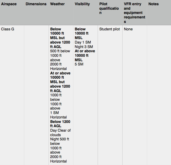
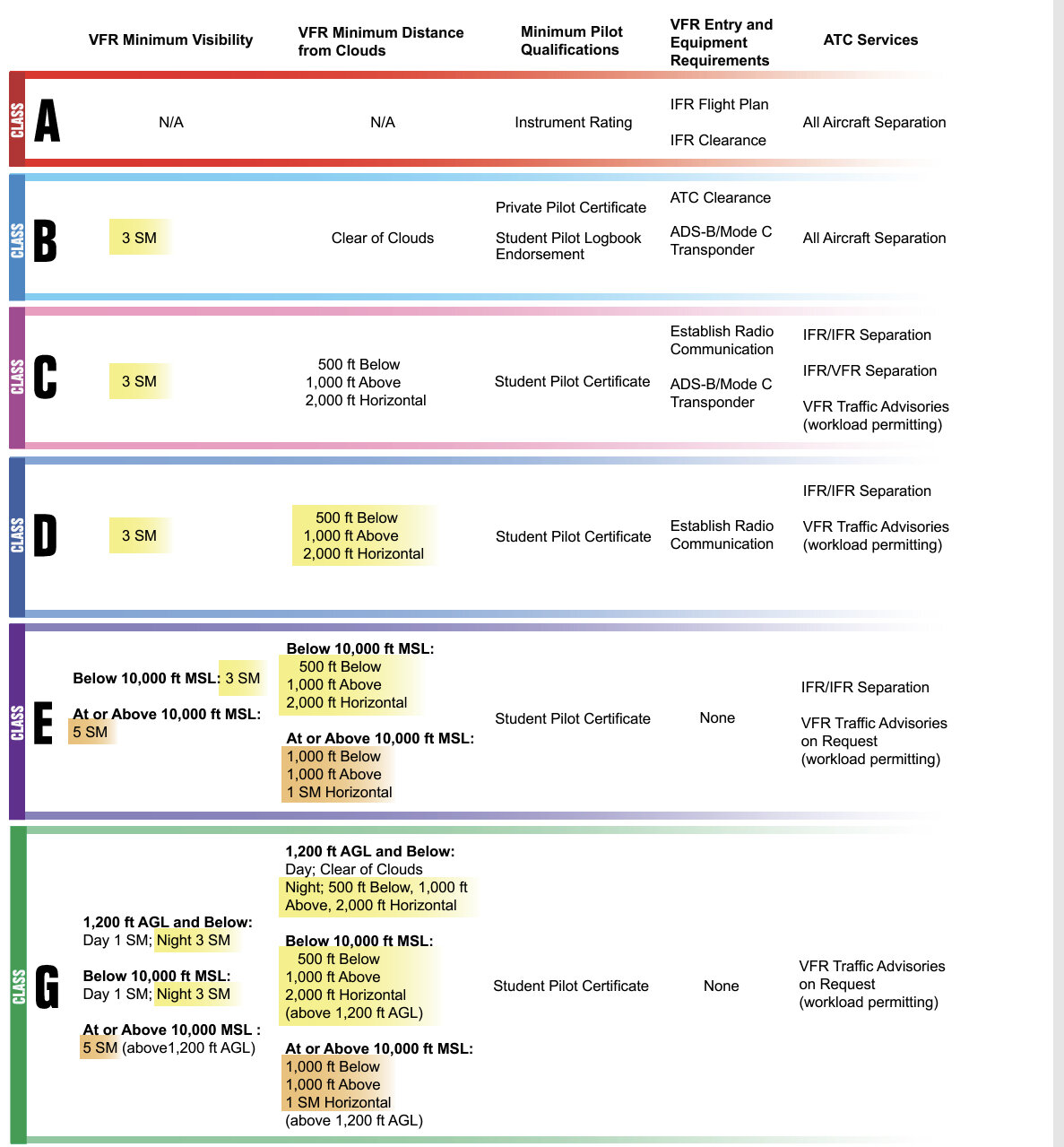
Class G
-
Class G airspace extends from the surface and extends up to the base of the overlying Class E airspace, normally 700 or 1,200 ft AGL
- Few areas of western U.S., Glass G can extend up to 14,500 ft MSL
Controlled Airspace
The important thing to know about operating in controlled airspace is that you may be subject to air traffic control. Controlled airspace consists of :
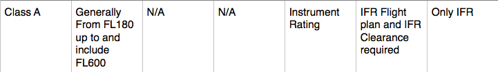
Class A
- All airspace from 18,000 ft MSL (FL180) up to and including (FL600) within the 48th contiguous States and within 12 NM offshore.
- ALL aircraft must be IFR unless otherwise authorized.
- No minimun Flight Visibility or distance from clouds is specified.
- Altimeter setting for all aircraft 29.92" Hg
- ADS-B OUT required.
Overview

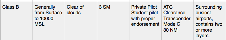
Class B
Overview
- SFC to 10,000 ft MSL surrounding busiest airports
- Clearance required to enter the airspace if on VFR rules.
- Hold private pilot certificate or student pilot the with required endorsement. Some airports won't allow student pilots (AIM 3-2-2).
- VFR weather: Visibility 3 SM, remain clear of clouds.
- Mode C Transponder and ADS-B OUT.
- Speed limit 250 KIAS below 10,000 ft ( 200 KIAS bellow or in VFR corridors)
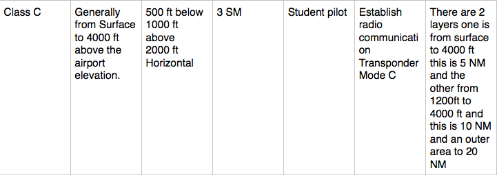
Class C
Overview
- SFC to 4,000ft MSL 10 NM radius. Outer area for communications 20 NM.
- Establish two-way communications to enter the airspace.
- VFR weather: 3 SM visibility; cloud clearance 500' ft below 1,000 above 2,000 ft horizontal.
- Speed limit 200 KIAS within 2,500 AGL and 4 NM of the primary airport.
- Mode C Transponder and ADS-B OUT required
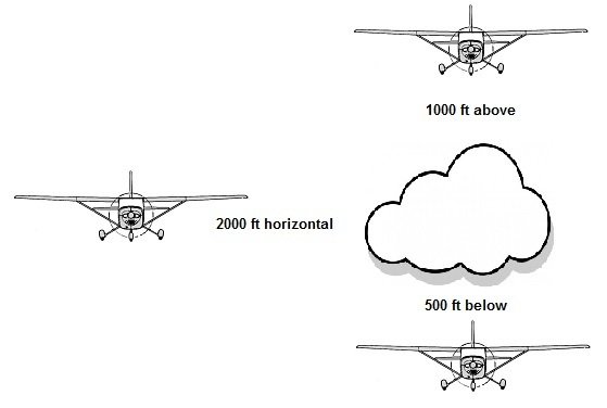
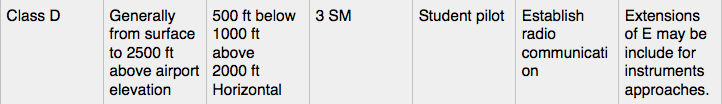
Class D
Overview
- SFC to 2,500 ft MSL.
-
Establish two-way communications to enter the airspace.
-
VFR weather: 3 SM visibility; cloud clearance 500' ft below 1,000 above 2,000 ft horizontal.
-
Speed limit 200 KIAS within 2,500 AGL and 4 NM of the primary airport.
Class E
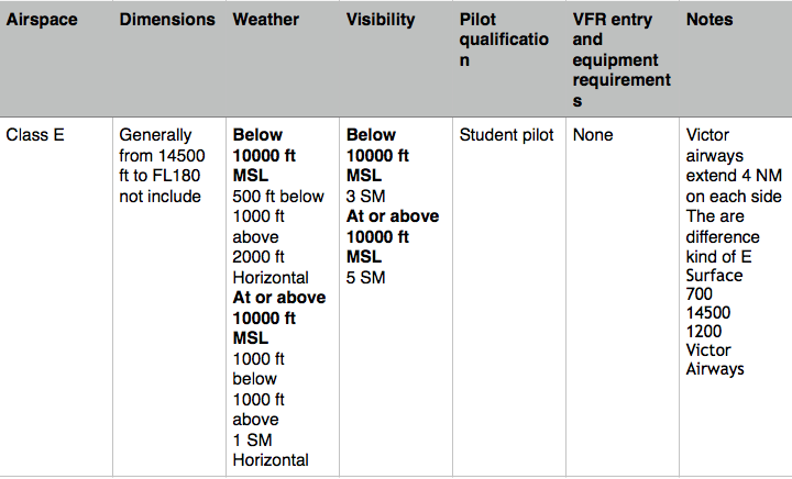
Overview
Class E airspace extends upward from either the surface or a designated altitude to the overlying or adjacent controlled airspace. Up to but not including FL180.
Weather Requirements: 3 SM visibility, Cloud clearance of 500' below 1,000 ft above 2,000 ft horizontal.
Equipment requirements: ADS-B OUT at or above 10,000 feet MSL. Excluding at and below 2,500 feet AGL;
Let's review
Where is ADS-B OUT required?
The FAA requires ADS-B Out capability in the continental United States, in the ADS-B rule airspace designated by FAR 91.225:
- Class A, B, and C airspace;
- Class E airspace at or above 10,000 feet MSL. Excluding at and below 2,500 feet AGL;
- Within 30 NM of a Class B airport (the Mode C veil);
- Above & below Class B or Class C airspace up to 10,000 feet;
- Class E airspace over the Gulf of Mexico, at and above 3,000 feet msl, within 12 nm of the U.S. coast.
Special VFR
- When the weather is below these VFR minimums, and there is no conflicting IFR traffic, a special VFR clearance may be obtained from the ATC facility having jurisdiction over the affected airspace.
- A special VFR clearance may allow you to enter, leave, or operate within most Class D and Class E surface areas and some Class B and Class C surface areas if the flight visibility is at least one statute mile and you can remain clear of clouds.
Airspeed
Limitations
- Flights below 10,000 ft MSL are limited to a maximum indicated airspeed of 250 KIAS
-
Airspace underlying Class B and in VFR corridors through Class B
- Class C or D airspace or below 2,500 ft above the surface, and within 4 nm from primary airport
-
There is a 200 KIAS restriction for
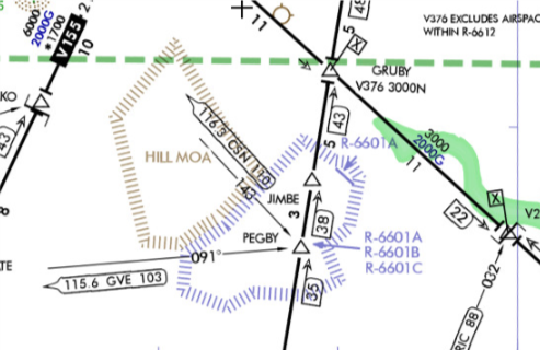
Special Use Airspace
(AIM 3-4-1)
Special use airspace or special area of operation (SAO) is the designation for airspace in which certain activities must be confined, or where limitations may be imposed on aircraft operations that are not part of those activities.
- Prohibited areas
Special use airspace usually consists of:
- Restricted Areas
- Controlled Firing Areas (CFA)
- Alert Areas
- Military Operation Areas (MOA)
- Warning Areas
Warning Areas
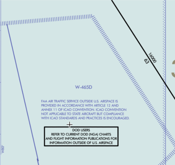
- Are similar in nature to restricted areas, A warning area is airspace of defined dimensions.
- Extending from 3 NM outward from the coast of the United States.
- Contain activity that may be hazardous to nonparticipating aircraft. A warning area may be located over domestic or international waters or both.
- The airspace is designated with a “W” followed by a number.
Alert Areas
- Are depicted on aeronautical charts with an “A”
- Inform nonparticipating pilots of areas that may contain a high volume of pilot training or an unusual type of aerial activity.
- Pilots should exercise caution in alert areas.
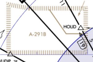
Restricted Areas
- Areas where operations are hazardous to nonparticipating aircraft.
- Restricted areas denote the existence of unusual, often invisible, hazards to aircraft (e.g., artillery firing, aerial gunnery, or guided missiles).
- Not active, allows the aircraft to operate in the restricted airspace without issuing specific clearance for it.
- Active, the ATC facility issues a clearance which ensures the aircraft avoid the restricted airspace
Military Operation Areas
(MOA)
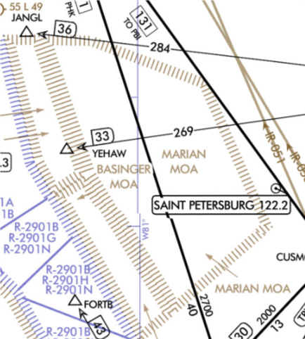
- A block of airspace in which military training and other military maneuvers are conducted.
- Exercise extreme caution when military training activity is being conducted.
Prohibited Areas
-
Contain airspace of defined dimensions within which the flight of aircraft is prohibited.
- The area is charted as a “P” followed by a number (e.g., P-40).

Controlled Firing Areas
- Controlled firing areas are not depicted on aeronautical charts.
- Its activities are discontinued immediately when a spotter aircraft, radar, or ground.
National Security Areas
National security areas (NSAs) are established at locations where there is a requirement for increased security and safety of ground facilities. Flight in NSAs may be temporarily prohibited to provide a greater level of security and safety. A NOTAM is issued to advise you of any changes in an NSA’s status.
Other Airspace Areas
(AIM 3-5-1)
Other airspace typically do not have the same types of restrictions or hazardous activities as SUA.
-
Local Airport Adivory Areas
-
Military Training Routes
-
Published VFR Routes
-
Parachute Jumping Aircraft Operations
-
Terminal Radar Service Areas
-
Temporary Flight Restrictions
Local Airport Advisory (LAA)
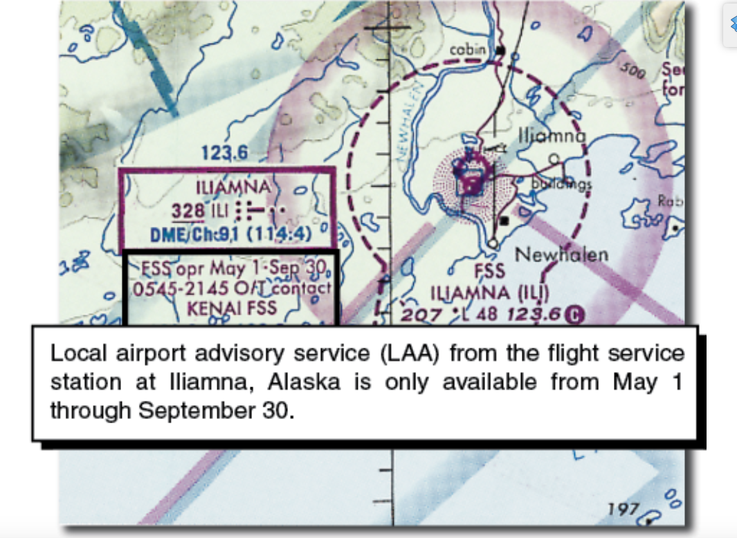
Local Airport Advisory (LAA) is a service provided by FSS facilities, which are located on the landing airport, have a discrete ground-to-air communications frequency or the tower frequency when the tower is closed, automated weather reporting with voice broadcasting, and a continuous ASOS/AWOS data display, other continuous direct reading instruments, or manual observations available to the specialist. Participation in the program is not mandatory but is encouraged. Safety is enhanced when everyone participates.
Military Training Routes
(MTRs)
- MTRs with no segment above 1,500 feet AGL are identified by numbers, like IR618 or VR618.
- MTRs are routes used by military aircraft to maintain proficiency in tactical flying.
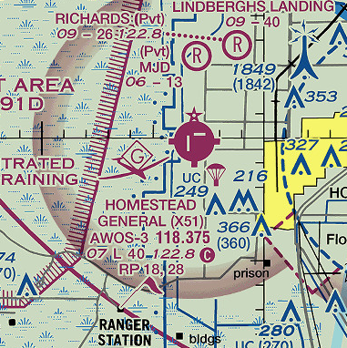
Parachute Jump Aircraft Operations
Parachute jump aircraft operations are published in the Chart Supplement (A/FD). Airport/Sites that are used frequently are depicted on sectional charts.

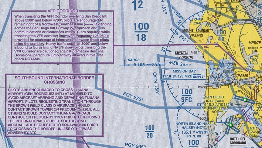
Published VFR Routes
Published VFR routes are for transitioning around, under, or through some complex airspace.
Terminal Radar Service Areas
(TRSAs)
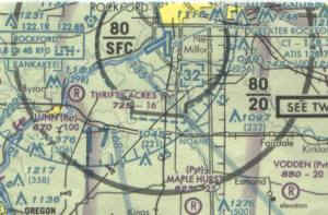
Depicted on VFR sectional charts with a solid black line.
- The purpose of the service is to provide separation between all IFR operations and participating VFR aircraft.
- TRSAs are areas where participating pilots can receive additional radar services.
Temporary Flight Restrictions (TFR)
- TFRs are regulatory actions that temporarily restrict certain aircraft from operating with defined area in order to protect persons or property in the air or on the ground
- A flight data center (FDC) Notice to Airmission (NOTAM) is issued to designate a TFR.
- The NOTAM begins with the phrase “FLIGHT RESTRICTIONS” followed by the location of the temporary restriction, effective time period, area defined in statute miles, and altitudes affected.
- Protect the President, Vice President, or another public figure.
- Provide a safe environment for space agency operations.
- Aerial Show / Big Event
- High Barometric Pressure (greater than 31.00" Hg)
Some of the purposes for establishing a TFR are
- Environmental Disaster
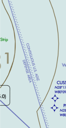
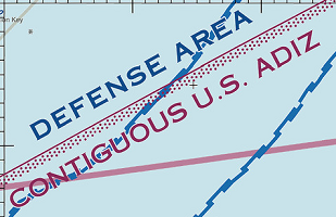
Air Defense Identification Zone (ADIZ)
- Failure to follow these rules may result in your aircraft being intercepted by U.S. security.
- Have an operating transponder with Mode C capability and a two-way radio to make periodic position reports.
- Air defense identification zones (ADIZs) are established to facilitate this identification in the vicinity of U.S. international airspace boundaries.
- Generally, you must file an IFR or defense VFR (DVFR) flight plan for all operations that enter or exit an ADIZ.
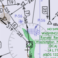
Washington DC Special Flight Rules Areas (SFRA)
- SFRA is depicted on charts and includes all airspaces within 30 NM radius, and up to FL180
- Identification, location, and control of aircraft is required in the interest of national security.
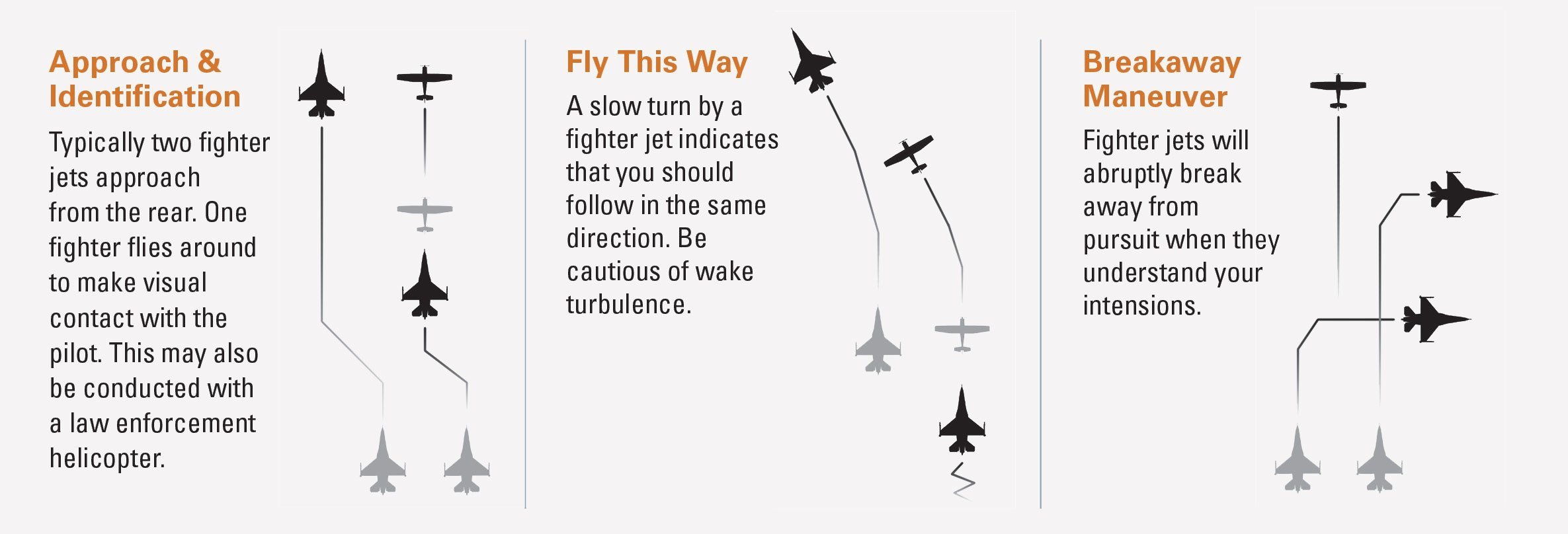
Interception Procedures
Use of 121.5 for communication if not on ATC already
Flight Information
Most of the flight information that pilots needs to conduct a safe flight in the NAS can be found at the faa.gov, as well as publications
Aeronautical Charts VFR and IFR
- Aeronautical charts are sources for are produced in electronic and printed formats.
- Aeronautical charts are sources for pilots to use for navigation references and topographic information.
- These charts are updated every 56 days.
Aeronautical Charts VFR
- Primary VFR navigation reference and depict topographic information, visual landmarks, and airport data.
Aeronautical Charts
IFR
- Instrument charts are being used by Jeppesen and the FAA.
- The FAA primarily produces instrument charts for the U.S.
- Jeppesen produces for most of the worls.
IFR Charts
- Aeronautical information for navigation under instrument flight rules below 18,000 feet MSL.
- Conterminous U.S. and Alaska) are designed for navigation at or above 18,000 ft MSL.
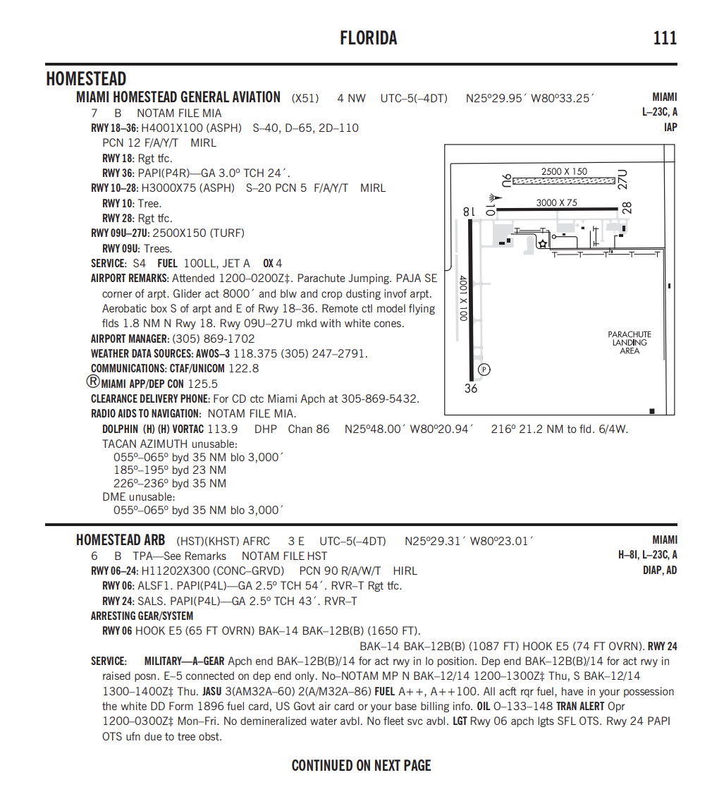
Chart Supplements
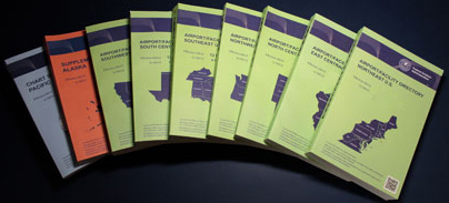
Chart Supplement includes data that cannot be readily depicted in graphic form: e.g., airport hours of operation, types of fuel available, runway data, lighting codes, etc.
Airport/Facility Directory
The AF/D is a pilot's manual that contains data on public use and joint use airports, seaplane bases heliports, VFR airport sketches, NAVAIDs, communications data, weather data sources, airspace, special notices, and operational procedures.
Electronic Flight Bag
(EFB)
EFBs can be used for flight planning and during each phase of flight. It displays a wide variety of information such as:
- Airport information
- Airport diagrams
- Moving map
- Weather displays
- Flight plans and routes
- Checklists and aircraft perfomance
- Digital logbook
- An EFB hosts applications, which are generally replacing conventional paper products and tools, traditionally carried in the pilot’s flight bag.
-
EFBs cannot replace any installed equipment required by operational or airworthiness regulations.
- You are required to have physical possession of aeronautical charts or information that will be essential for the completion of the flight.
Notice to Airmen
NOTAMS
A NOTAM is a notice containing information essential to personnel concerned with flight operations but not known far enough in advance to be publicized by other means.
- NOTAMs indicate the real-time and abnormal status of the NAS impacting every user.
- NOTAMs concern the establishment, condition, or change of any facility, service, procedure or hazard in the NAS.
- NOTAMs have a unique language using special contractions to make communication more efficient
-
NOTAM (D)
- FDC NOTAMs
- Military NOTAMs
Type of NOTAMS
- International NOTAMs
-
Information is disseminated for all airports listed in the Chart Supplement.
- Information includes such data as taxiway/Runway closures, personnel and equipment near or crossing runways, and airport lighting aids that do not affect instrument-approach criteria, such as a VASI.
NOTAMS (D)


(FDC) NOTAMS
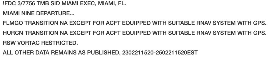
- Used to advertise Temporary flight restrictions (TFRs) caused by such things as natural disasters or large-scale public events that may generate a congestion of air traffic over a site.
- FDC NOTAMs contain amendments to published IAPs and other current aeronautical charts.
Military NOTAMS
-
Any NOTAM that is part of the military NOTAM system which primarily includes NOTAMs on military airports and military airspace.
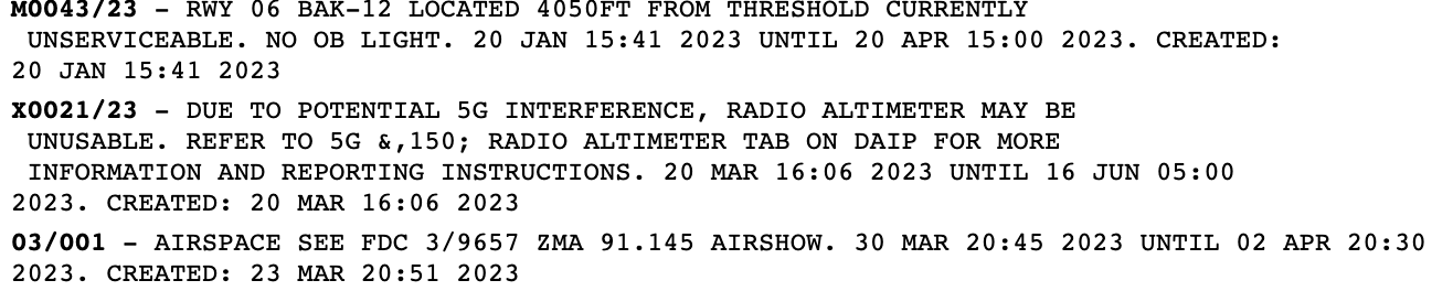
- Distributed to more than one country, they are published in ICAO format under guidelines established in Annex 15.
International NOTAMS
- Not every topic of a U.S. Domestic NOTAM is issued as an International NOTAM by the U.S. When possible, the U.S. International NOTAM will be linked to the appropriate U.S. Domestic NOTAM.
Federal Aviation Regulations (FARs)
The Federal Aviation Regulations (FARs) are rules prescribed by the Federal Aviation Administration (FAA) governing all aviation activities in the United States. The FARs are part of Title 14 of the Code of Federal Regulations (CFR).
Aeronautical Information Manual (AIM)
-
The Aeronautical Information Manual (AIM) is the FAA's official guide to basic flight information and Air traffic control (ATC) procedures.
-
The AIM contains the basic aeronautical knowledge information required to fly in the United States National Airspace System for VFR and IFR operations.
-
It also contains items of interest to pilots concerning health and medical facts, factors affecting flight safety, a pilot/controller glossary of terms used in the ATC System, and information on safety, accident, and hazard reporting.
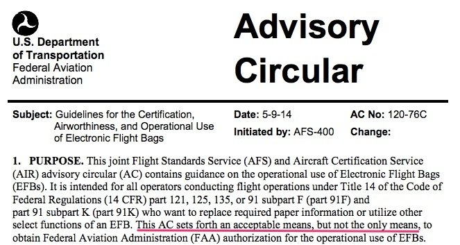
Advisory Circulars
Informative in nature letter that provides guidance for compliance with Airworthiness, Pilot certification and operational standards within the FAR/AIM title CFR 14.