GL 4 The Flight Environment

Rev 11/2024
Disclaimer
Students should use their textbooks, syllabus, and Airman Certification Standards (ACS) as their primary sources of information. EcFlight is an online training tool designed to simplify and enhance your ground school learning experience. However, it is not a substitute for FAA- or school-approved study materials. Before using these slides for study, always refer to your officially approved resources, such as the Jeppesen physical or electronic book and other FAA-approved materials.
Reference Books
- Pilot's Handbook of Aeronautical Knowledge(FAA-H-8083-25B). (2016). Oklahoma City, OK: United States Department of Transportation, Federal Aviation Administration, Airman Testing Standards Branch.
- Private Pilot Syllabus (10001292-002). (2012). Englewood, CO: Jeppesen.
- https://www.aopa.org/lms/courses/ga-security/#03-passengers&02-what-to-look-for
- “SKYbrary Wiki.” Hypoxia - SKYbrary Aviation Safety, www.skybrary.aero/index.php/Weather_Radar.
Reference Multimedia
- ERAUSpecialVFR. (n.d.). Motion picture.
- https://www.boeing.com/commercial/aeromagazine/articles/qtr_02_10/2/img/A2_fig3.jpg
- http://www.paul.moggach.yorksoaring.com/GliderInstructorGSX/rightofway1.jpg
- (N.d.-b). Retrieved from https://aviatorsguide.wordpress.com/2020/06/22/aircraft-exterior-lighting/.
- Brady, J. (2021). VASI & PAPI lighting systems . YouTube. https://www.youtube.com/watch?v=Y9UfyNsxyVI
- (N.d.-b). Retrieved from https://unitingaviation.com/news/safety/an-important-reminder-about-wearing-your-seat-belt-in-flight/.
- (N.d.-b). Retrieved from https://www.nydailynews.com/2023/01/15/remembering-the-miracle-on-the-hudson/.
- (N.d.-b). Retrieved from https://www.wetraobstructionlight.com/applications/.
Index
Section A - Safety of Flight

Section B - Airports
Section C - Aeronautical Charts
Section D - Airspace
Safety of Flight
Pilot in Comand
You 🫵🏽 as a Pilot in Command (PIC) have the final authority and responsibility for the safe operation during flight.
Your responsibilities as PIC are:
- Preflight actions
- Becoming familiar with all information concerning the flight
- Safety briefings to the passengers
- Determine runway lengths, takeoff and landing distances, and performance data
- Check weather reports and forecasts, fuel requirements, and available alternates if necessary
- Be aware of any air traffic control (ATC) orders and not deviate from that clearance
- Take the final decision in case of emergency
Collision Avoidance
The risk of an in-flight collision exists for all pilots, but you can take action to avoid this type of accident with the use of:
Exterior Lights (position, beacon, strobes)
Radio Transmissions (active communication)
ATC Services* (traffic reporting & spacing)
*Remember ATC might not be able to see all VFR traffic in the area, so it is the pilot's responsibility to see and avoid other aircraft effectively.
Visual Scanning
-
You must develop an effective scanning technique.
-
The average person has a field of vision of approximately 200º. However, the area in which the eye can focus is a relatively narrow cone of sight (usually 10º).
- The most effective way to scan during day light hours is through a series of short, regularly spaced eye movements in 10º sectors.
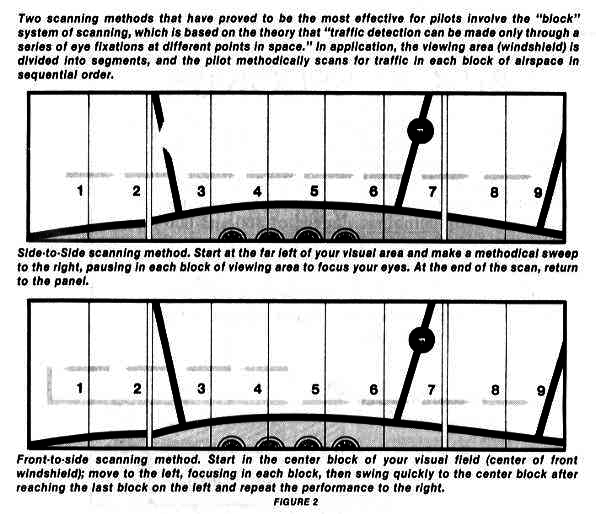
- The eyes should stop for at least one second in each sector.
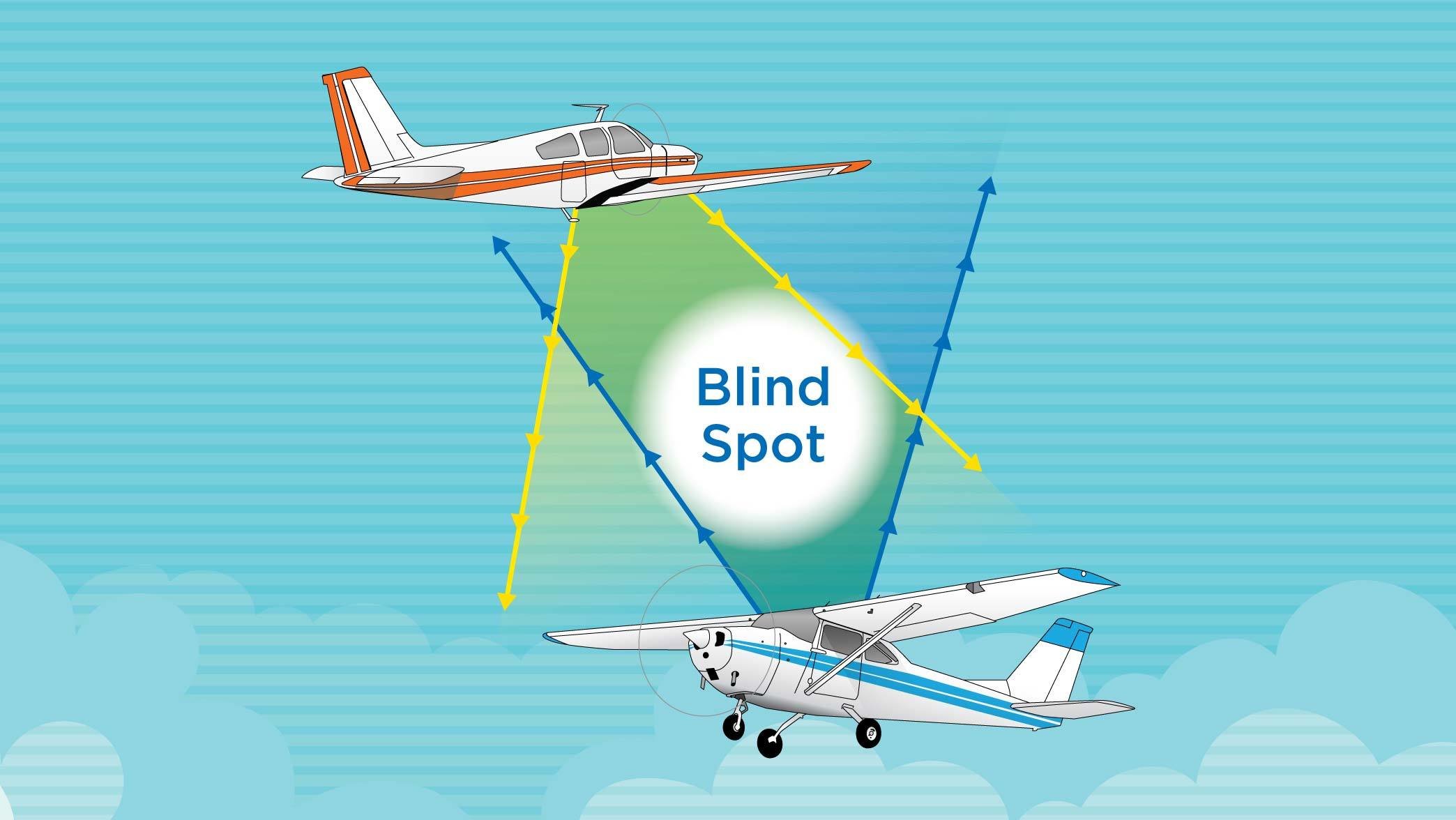
In both high wing and low wing aircraft designs, portions of your view are blocked by the fuselage and wing.
This can make difficult to see conflicting traffic.
Blind Spot and Aircraft Design
Cockpit Traffic Displays
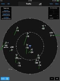
- Enhances traffic situational awareness through the display of other aircrafts' positions to pilots and flight crew.
- The display uses GPS to determine the position of the aircraft you're in.
- The display processor decodes the raw messages from GPS signals to determine the identity, position (latitude, longitude), altitude, and velocity of detected aircraft.
Airport Operations
- To increase the safety of the airport environment, a voluntary program called 'Operation Lights On' has been established by the FAA.
Operation Lights On encourages you to use:
- Landing lights during departures and approaches, during both day and night operations, especially within 10 miles of the airport.
Maneuvers in the Training Area
Clearing Turns
- Clearing turns consist of at least a 180 degree change in direction prior to entering any maneuver.
- This allows you to see areas blocked by blind spots.
- You can usually perform a 90 degree turn in one direction followed by a 90 degree turn to the other direction OR one complete 180 degree turn to satisfy the clearing turns requirement.
Right-of-Way Rules
When weather conditions permit, regardless of whether an operation is conducted under instrument flight rules or visual flight rules, vigilance shall be maintained by each person operating an aircraft so as to see and avoid other aircraft.
Any aircraft in distress has the right of way over all others "
🚨REMEMBER🚨
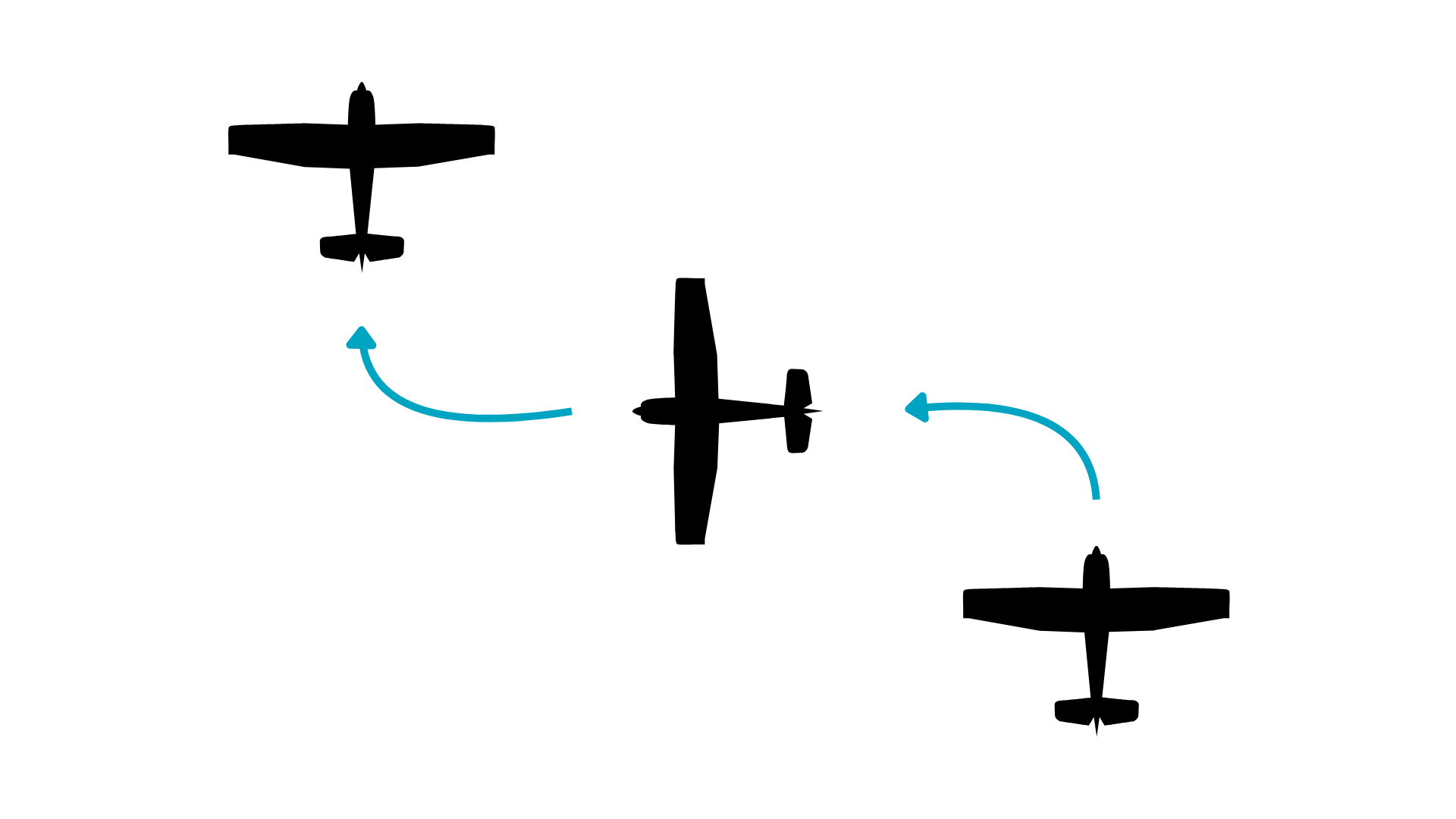
Converging Aircraft
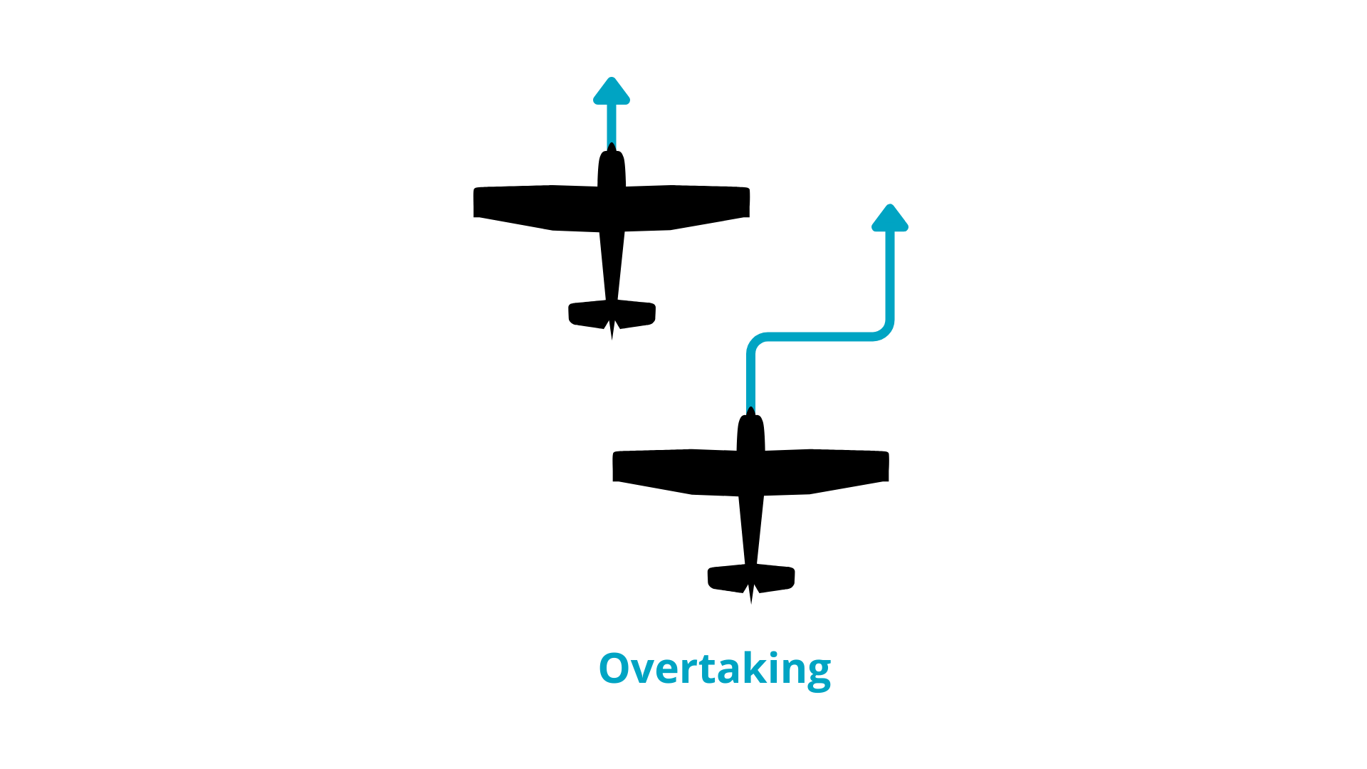
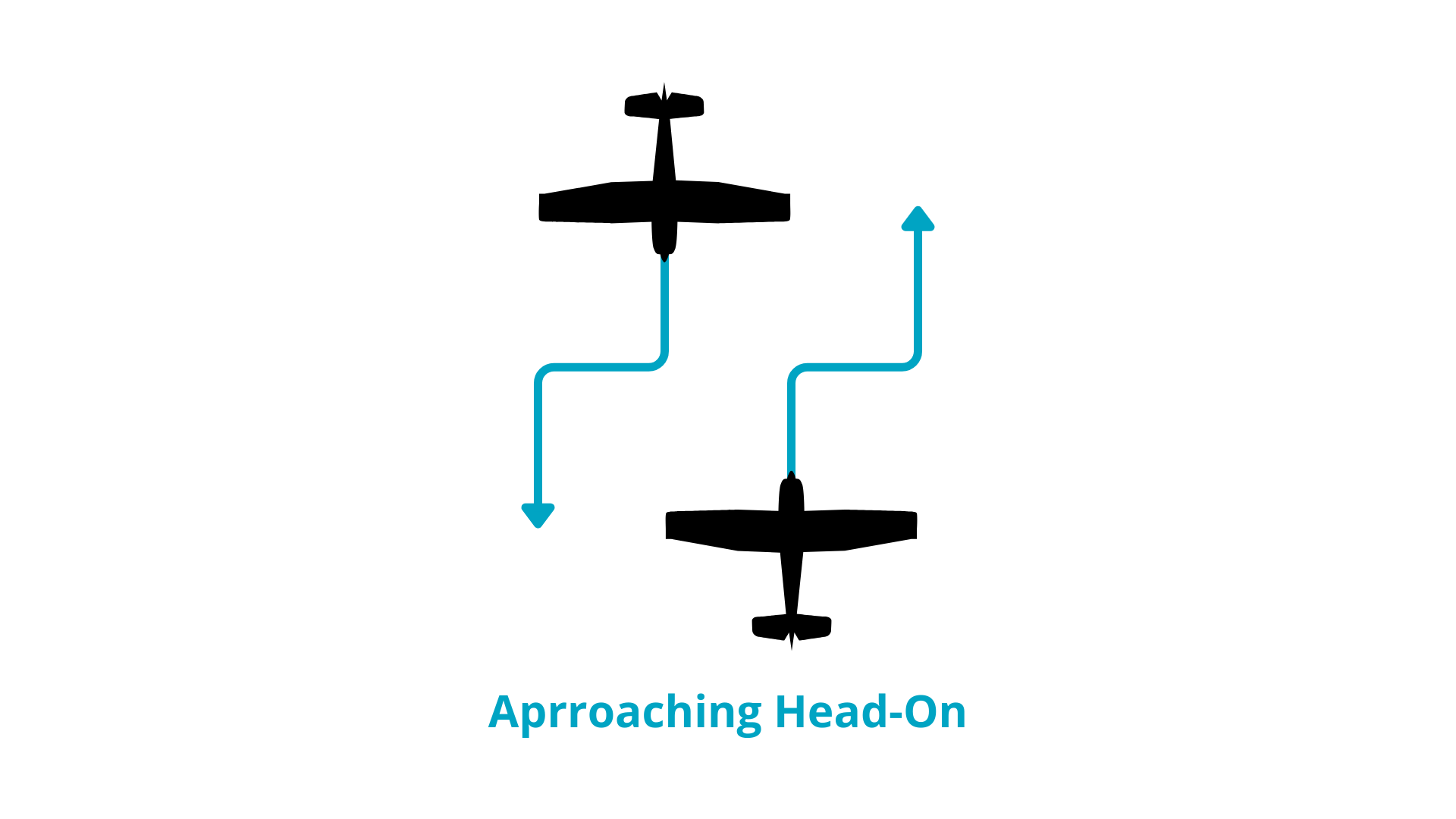
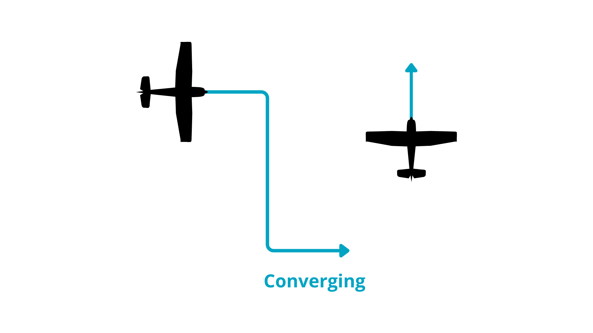
Right-Of-Way Rules
Right-of-way rules
Aerobatic Flight and Experimental Aircraft
Aerobatic flight involves intentional maneuvers that result in abrupt changes to an aircraft's attitude or acceleration, which are not part of regular flight.
To perform aerobatics you must:
- Be at least 1,500 ft above ground level and have at least 3 statute miles of visibility.
- Not be over a congested area or within the lateral boundaries of any controlled airspace extending to the surface around an airport or in the airspace designated for federal airway.
- Not carry passengers, and if you have passengers, you may not perform any intentional maneuver that exceeds a nose-up or nose-down attitude of 30 degrees.
- Have certified parachutes.
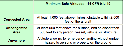
Minimum Safe Altitude
- Except when necessary for takeoff or landing, no person may operate an aircraft below the following altitudes:
Wire Strike Avoidance
- Be aware of your position and altitude.
- Check sectional charts for any antennas or obstructions. Keep in mind; cables are used to support the antennas.
- Review the maximum elevation figure of your area.
Dropping Objects
The FAA allows the release of objects from an aircraft as long as you take proper precautions to prevent injury or damage to people or property below.
Dropping Objects
Flight Over Hazardous Terrain
-
To operate over mountainous terrain or open water, a pilot needs to obtain specialized training from an authorized instructor who has previous training in the area.
- Additional factors need to be considered, flying over open water, packing appropriate survival gear, navigating mountainous terrain, encountering server turbulence, performance at high altitudes, & rapidly changing weather.
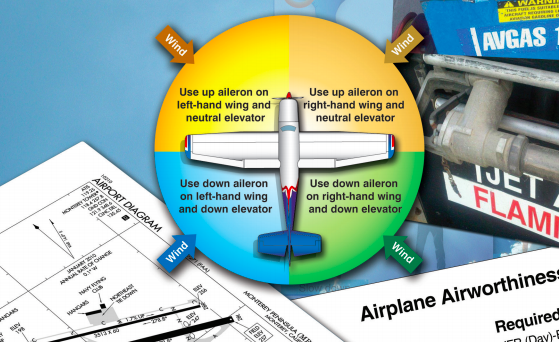
Taxiing in Wind
The proper use of the aileron and elevator controls normally will counteract the wind and help you to maintain control of your airplane.
Safety Belts
Safety Belts
- As a flight crewmember you are required to keep your safety belt and shoulder harness fastened during takeoffs and landings.
- Safety belts should stay fastened while en route.
- As PIC, you must brief your passengers to use safety belts during taxi, takeoff, and landing.
Positive Exchange of Flight Controls
Pilots use a 3-step verbal process to exchange the aircraft controls, but you should always remember to check visually as well.
- Pilot passing controls: “You have the flight controls”
- Pilot taking the controls: “I have the flight controls”
- Pilot passing controls : “You have flight the controls”
NTSB Part 830
In case you have an emergency, you should refer to NTSB Part 830 to determine the circumstances and requirements to report the event.
-
Aircraft accident: serious injury, death, or substantial damage to aircraft.
- Substantial damage: adversely affects structural strength or flight characteristics.
- Serious injury: requires hospitalization, internal organ damage, or bone fracture.
NTSB 830.5: Defines serious incidents that require immediate notification.
Airports
Controlled and Uncontrolled Airports
Controlled: have at least a part-time operating control tower. Air Traffic Control (ATC) is responsible for providing the safe, orderly flow of air traffic at airports and it is required for pilots to maintain two-way radio communication with ATC.
Controlled
Uncontrolled
Uncontrolled: No operating control tower, two-way radio communications are not required, although it is a good operating practice for pilots to transmit their intentions on the specified frequency for the common traffic advisory frequency (CTAF).
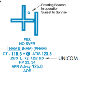
1. The CTAF may be a Universal Integrated Community (UNICOM), MULTICOM, Flight Service Station (FSS), or tower frequency and is identified in the appropriate aeronautical publications.
2. UNICOM is a nongovernment air/ground radio communication station which may provide airport information at public-use airports where there is no tower or FSS. UNICOM might include weather information, wind direction, the recommended runway, etc.
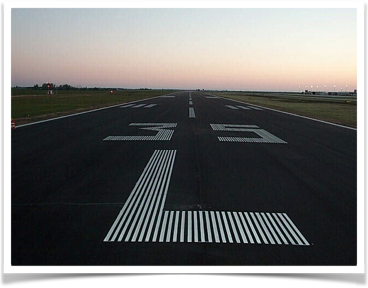
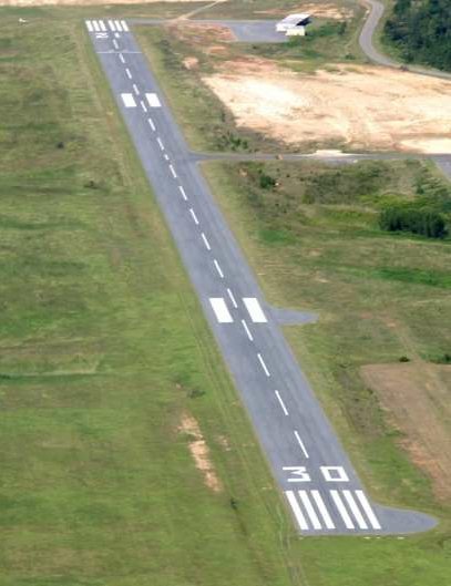
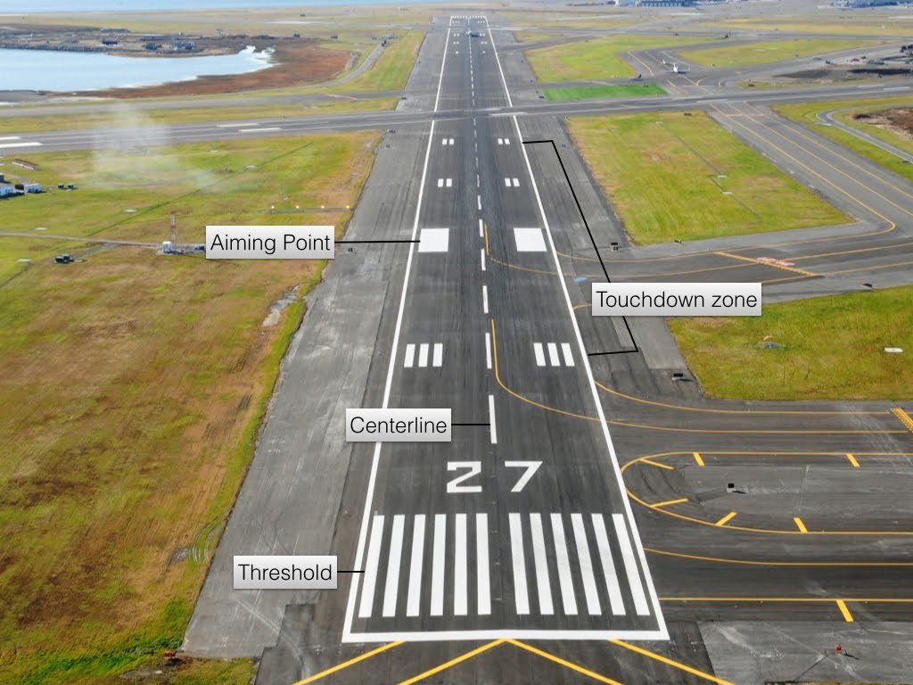
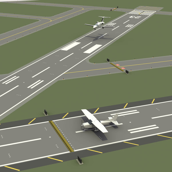
Runway Layout
- All runway surface markings are white.
- Runways are identified using numbers.
-
Numbers are based on the magnetic heading of runway rounded to the nearest ten.
- Position of runways can be further defined by using 'L' (Left), 'R' (Right), or 'C' (Center), as appropriate.
Heading 350
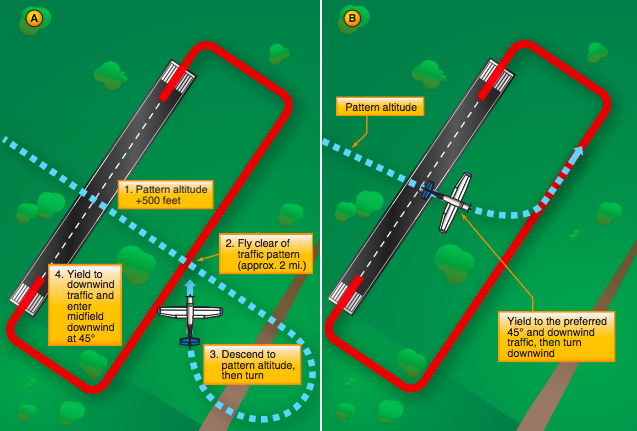
Traffic Pattern
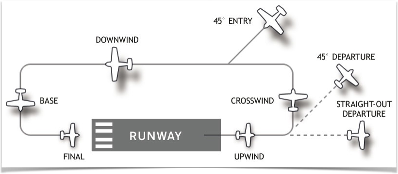
- Ensures that air traffic flows into and out of an airport in an orderly manner.
- Standard pattern side is the left, all turns to the left.
- Traffic pattern altitude for propeller-driven aircraft generally extends from 600 ft to as high as 1,500 ft AGL.
- Check the traffic pattern altitude in the A/FD.
Safety Considerations
When in the traffic pattern, pilots must continue to scan for other aircraft and check blind spots caused by fixed aircraft structures.
Safety Considerations
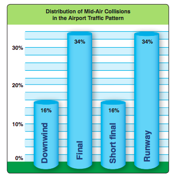
- Mid-air collisions generally occur during daylight hours with good visibility.
- The majority of pilots involved in mid-air collisions are not on a flight plan.
- Nearly all accidents occur at or near uncontrolled airports and at altitudes below 1,000 feet.
- Pilots of all experience levels are involved in mid-air collisions.
Safety Considerations
Wind Direction Indicators
Segmented Circle
- At airports without an operating control tower, a segmented circle is a visual indicator, usually located in a position with maximum visibility for pilots.
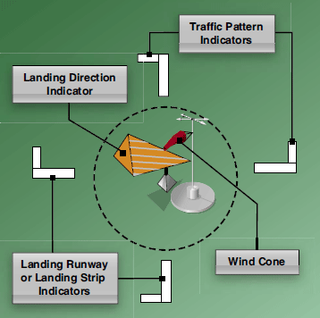
- The segmented circle consists of the following components: wind direction indicators, landing direction indicators, landing strip indicators, and traffic pattern indicators.
At uncontrolled airport, you can determine landing direction by observing the segmented circle. The extension of the legs on the segmented circle indicate the side the traffic pattern turns to.
Airport Visual Aids
The airport environment can seem confusing. However, just as you learn how to interpret traffic signals, road signs and highway markings, you will soon become familiar with visual aids at an airport.
Runway and Taxiway Markings

Precision Instrument
Nonprecision Instrument
Visual
Runway Markings
Additional Markings
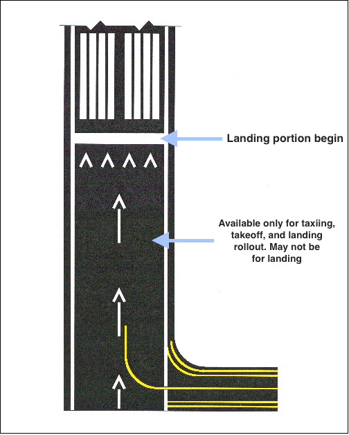
Used for taxi and takeoff, but NOT for landing
Displaced Threshold
Blast Pads
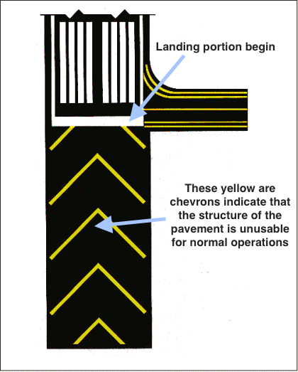
May NOT be used for taxi, takeoff, or landing
Closed Runways
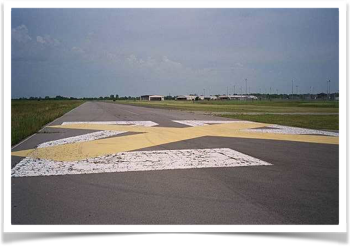
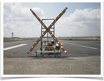
- Temporarily Closed: Yellow X’s are placed at each approach end of the runway. Temporary X’s may be lighted.
- Permanently Closed: Yellow X’s are placed at each approach end of the runway and at every 1000 ft. interval. Threshold markings are obliterated.
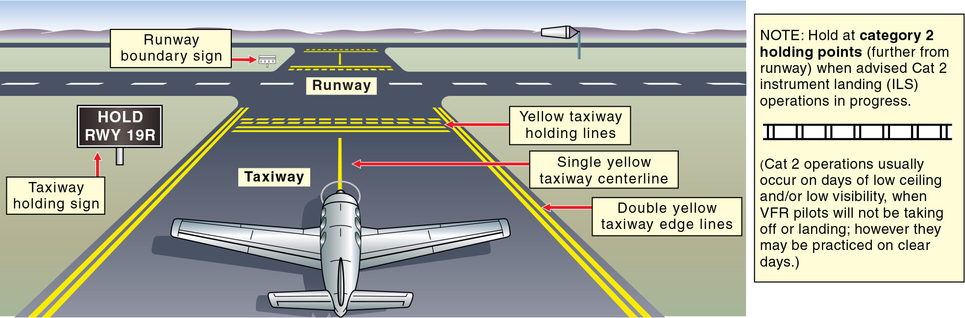
Taxiway Markings
- Taxiways have a letter designation to be identified.
- They are easy to identify by continuous yellow center stripes.
- The link between the airport parking areas and the runways are the taxiways.
click here
Hold Short Line
-
NEVER cross the solid side of a Hold Short Line unless you are cleared for takeoff or are ABSOLUTELY SURE that you have ATC permission to cross!
-
If you are not sure if you are cleared to cross a hold short line, ASK!
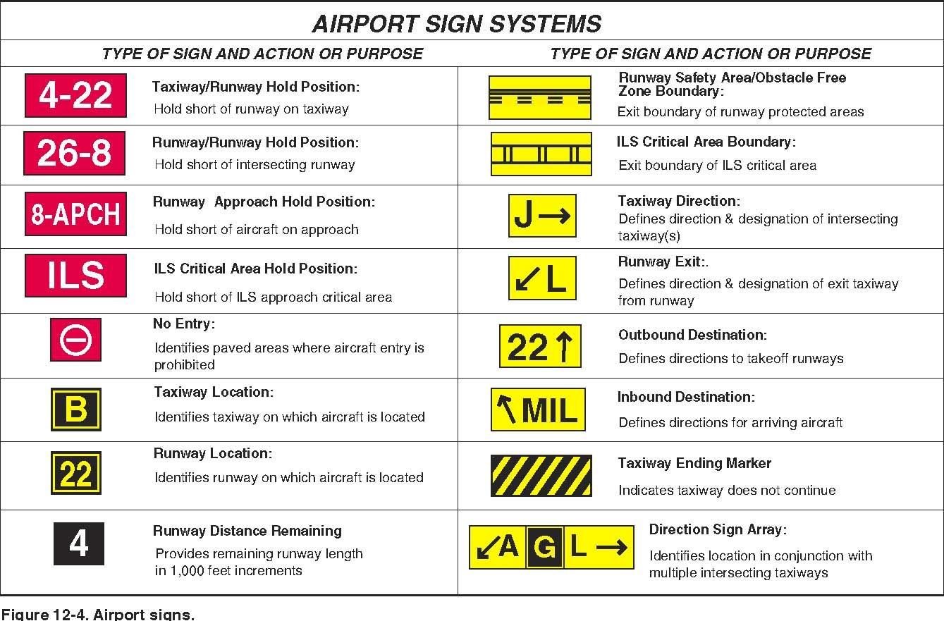
Airport Signs
Ramp Area Hand Signals
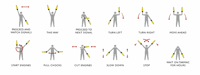
As a pilot, you need to be familiar with the signals provided to park the airplane.
Ramp Area
- Where the airport parking area is located. Also known as the Non-Movement Area.
- Inside the Non-Movement Areas, pilots can move without ATC clearance.
Movement Areas are considered taxi ways and runways. Pilots need ATC clearance before moving the airplane around on any of these surfaces.
Runway Incursion Avoidance
A runway incursion is “any occurrence in the airport runway environment involving an aircraft, vehicle, person, or object on the ground that creates a collision hazard or results in a loss of required separation with an aircraft taking off, intending to take off, landing, or intending to land.”
Prevent a Runway Incursion
Proper planning can prevent runway incursions and the possibility of a ground collision. A pilot should be aware of the aircraft’s position on the surface at all times and be aware of other aircraft and vehicle operations on the airport.
-
The following are some practices to help prevent a runway incursion:
- Read back all runway crossing and/or hold instructions.
- Review airport layouts as part of preflight planning, before descending to land and while taxiing, as needed.
- Know airport signage.
- Review NOTAMs for information on runway/taxiway closures and construction areas.
- Request progressive taxi instructions from ATC when unsure of the taxi route.
- Check for traffic before crossing any runway hold line and before entering a taxiway.
- Turn on aircraft lights and the rotating beacon or strobe lights while taxing.
- When landing, clear the active runway as soon as possible, then wait for taxi instructions before further movement.
- Study and use proper phraseology in order to understand and respond to ground control instructions.
- Write down complex taxi instructions at all times
Land and Hold Short Operations
- The Land and Hold Short Operation is an ATC tool used to increase airport capacity, and maintain system efficiency.
- You must complete specific knowledge-based training before participating in LAHSO.
- In addition, solo student pilots are not authorized to participate in LAHSO.
Pilot Responsibility
- Only accept LAHSO clearance if you have determined that your aircraft can land safely and stop within the available landing distance (ALD).
- If you have the slightest doubt that you cannot complete the LAHSO, decline the clearance.
- LAHSO clearance is available only when the visibility is at least 3 SM with 1,000 ft ceilings.
Airport Lighting
Once you gain some experience in the cockpit, you will soon go from only flying during daylight hours to the new challenge of night time flying!
This will bring a whole view of the world, especially with the lighting systems you'll encounter.
Airport Beacon
- At night airport beacons are used to guide pilots to lighted airports.
- Airport beacons operated during daylight hours normally indicate that the weather at the airport involves ceilings less than 1,000 ft or ground visibility less than 3 SM.
Visual Glideslope Indicators
-
Visual Glideslope Indicators are light systems which indicate your position in relation to the desired glide path that leads to the runway.
- The are located one side or the other of the runway.
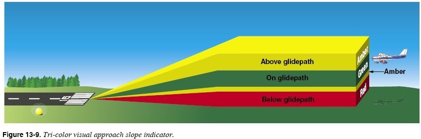
Visual Approach Slope Indicator (VASI)
-
Two-bar systems have near and far bars.
-
Provides obstacle clearance within 4NM of the runway threshold within 10º of centerline.
-
A tri-color VASI uses a single light unit to project a three-color visual path.
Precision Approach Path Indicator (PAPI)
-
It has two to four lights installed in one single row instead of a far bar and a near bar.
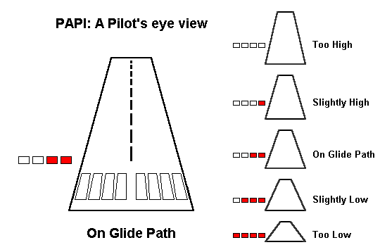
-
The PAPI is normally located on the left side of the runway and can be seen from up to 5 miles during the day and 20 miles at night.
Precision Approach Path Indicator (PAPI)
Approach Light Systems
-
Approach Light Systems help instrument pilots transition to visual references at the completion of an instrument approach.
- They extend 2,400ft to 3,000ft from precision instrument runways.
- They extend 1,400ft to 1,500ft from non-precision runways.
Systems Include
- Sequence flashing lights (SFL)
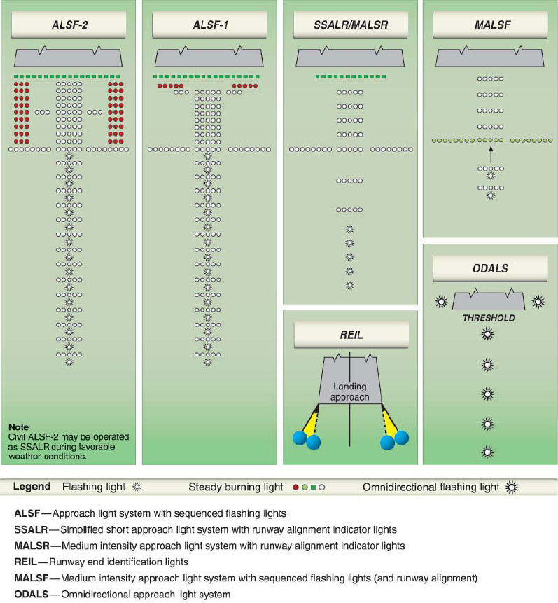
- Runway Alignment Indicator Lights (RAIL)
-
Classified according to three intensity levels. High-intensity runway lights (HIRLS) are the brightest runway lights available. Medium intensity runway lights (MIRLS) and low-intensity runway lights (LIRLS) are, as their names indicate, dimmer in intensity.
-
Consists of a single row of white lights bordering each side of the runway and lights identifying the runway threshold.
Runway Lighting
2,000feet remaining
click here
-
Obstruction lights are installed on prominent structures such as towers or
buildings.
- Flashing red lights or high intensity strobe lights warn pilots of any obstructions.
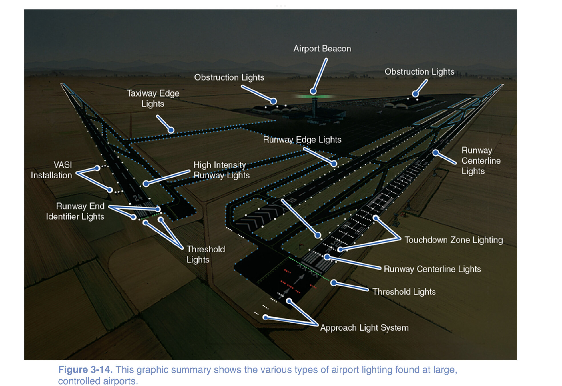
Taxiway Lighting
-
As you taxi off the active runway, blue lights, lining both edges of the taxiway, guide you from the runway to the ramp area.
Pilot-Controlled Lighting
-
Key your mic seven times on the specified frequency to turn all the lights on at maximum intensity.
-
Key the mic five times for medium-intensity lighting and three times for the lowest intensity.
Obstruction Lighting
-
These lights are used on and off the airport premises.
-
Obstruction lights give you warning of prominent structures such as towers, buildings, and even power lines.
Airport Security
Unauthorized use of assets by criminals or terrorists can lead to an actual security-related event. With over 19,000 landing facilities in the U.S., security cannot effectively address the needs of each one.
- Locking up your aircraft and securing airport property
- Looking out for suspicious or criminal activity and taking appropriate action
Avoid theft by:
What To Look For
Be alert to people who appear to be:
- Forcing their way into an aircraft, or through a fence or gate.
- Loitering for no apparent reason.
- Recording video or taking photos of aircraft, facilities, fencing, or hangars.
- Suspiciously approaching and peering into multiple aircraft.
- Anything that strikes you as unusual under the circumstances.
Aeronautical Charts
Latitude and Longitude
Any specific geographical point can be located by reference to its longitude and latitude.
Latitude
- The equator is the imaginary line that circles the Earth midway between the north and south poles.
- You can locate a position north or south of the equator by using parallels, or lines of latitude, which form small circles around the Earth.
- As a reference point, the equator is labeled as 0° of latitude.
- The parallel lines north of the equator are numbered from 0° to 90°, with 90° north latitude positioned at the north pole.
Longitude
- Meridians, or lines of longitude, are imaginary lines that extend from the north to the south pole.
- Since they connect the poles, lines of longitude always are given in a direction of true north and south.
- Just as the equator is designated 0° of latitude, the Prime Meridian, which passes through Greenwich, England, is labeled 0° of longitude.

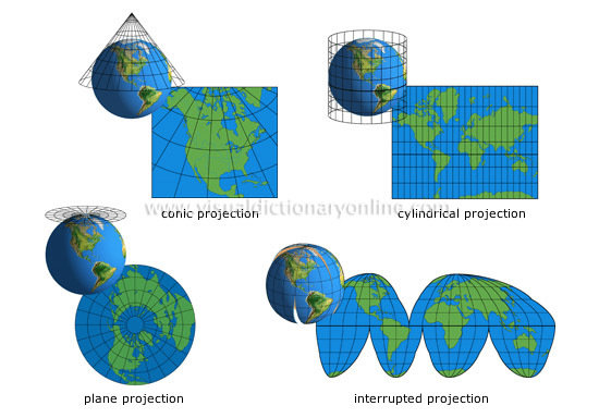
Projections
Projections are used for transferring a section of the Earth’s surface onto a flat chart.
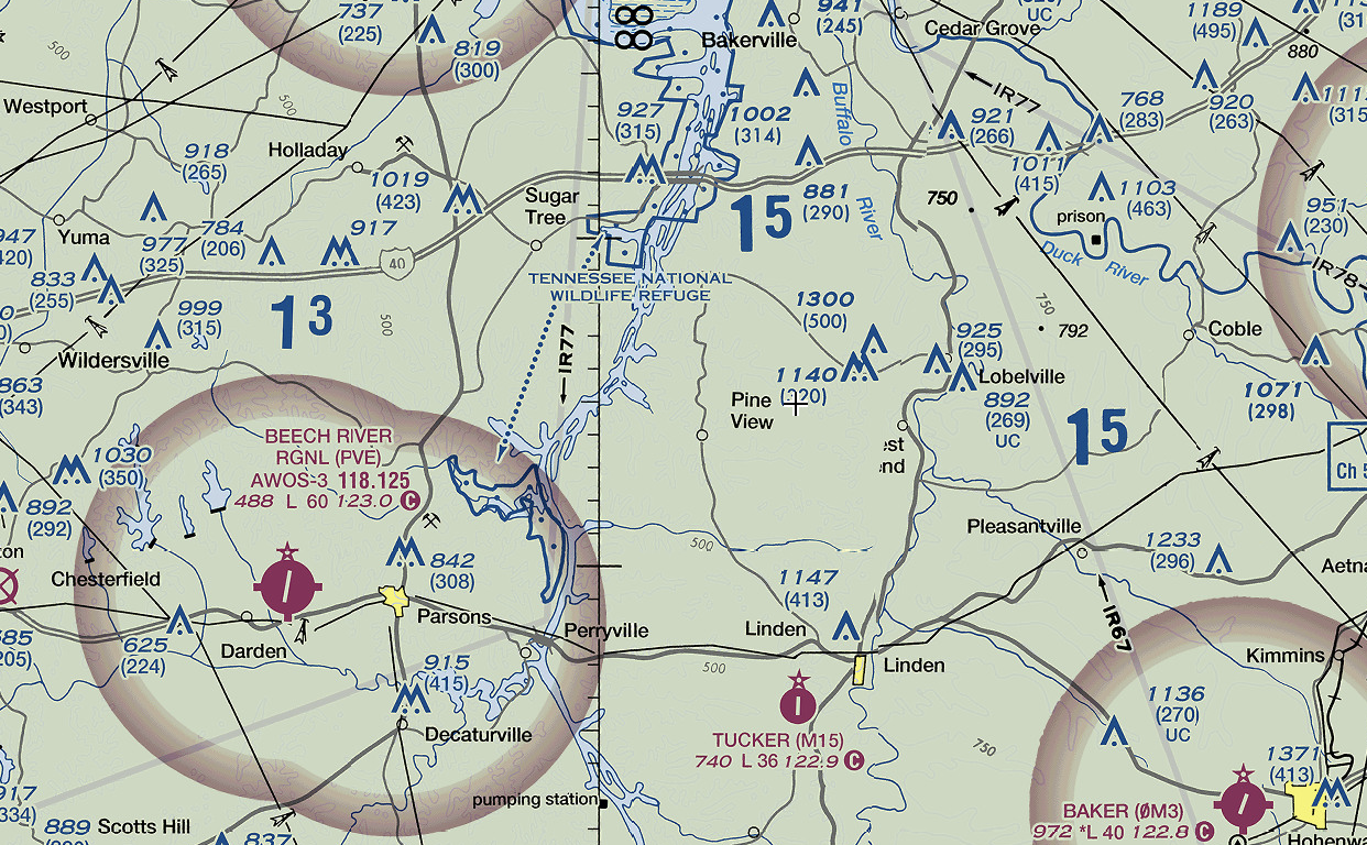
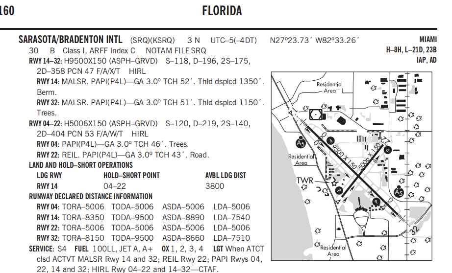
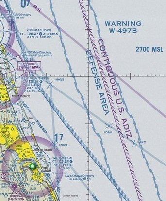
Sectional Charts
- Sectional charts are the most common charts used by pilots today. The charts have a scale of 1:500,000.
- The charts provide an abundance of information, including airport data, navigational aids, airspace, and topography.
- These charts are revised semiannually except for some areas outside the conterminous United States where they are revised annually.
VFR Terminal Area Charts (TAC)
- VFR terminal area charts are helpful when flying in or near Class B airspace. They have a scale of 1:250,000 (1 inch = 3.43 NM or approximately 4 NM).
- These charts provide a more detailed display of topographical information and are revised semiannually.
Chart Symbology
-
The legend is your tool for deciphering symbols and decoding aeronautical chart information.
- Divided into seven categories, the legend describes symbology for airports, airport data, radio aids to navigation and communication boxes, airport traffic service and airspace information, obstructions, topographic information, and miscellaneous data.
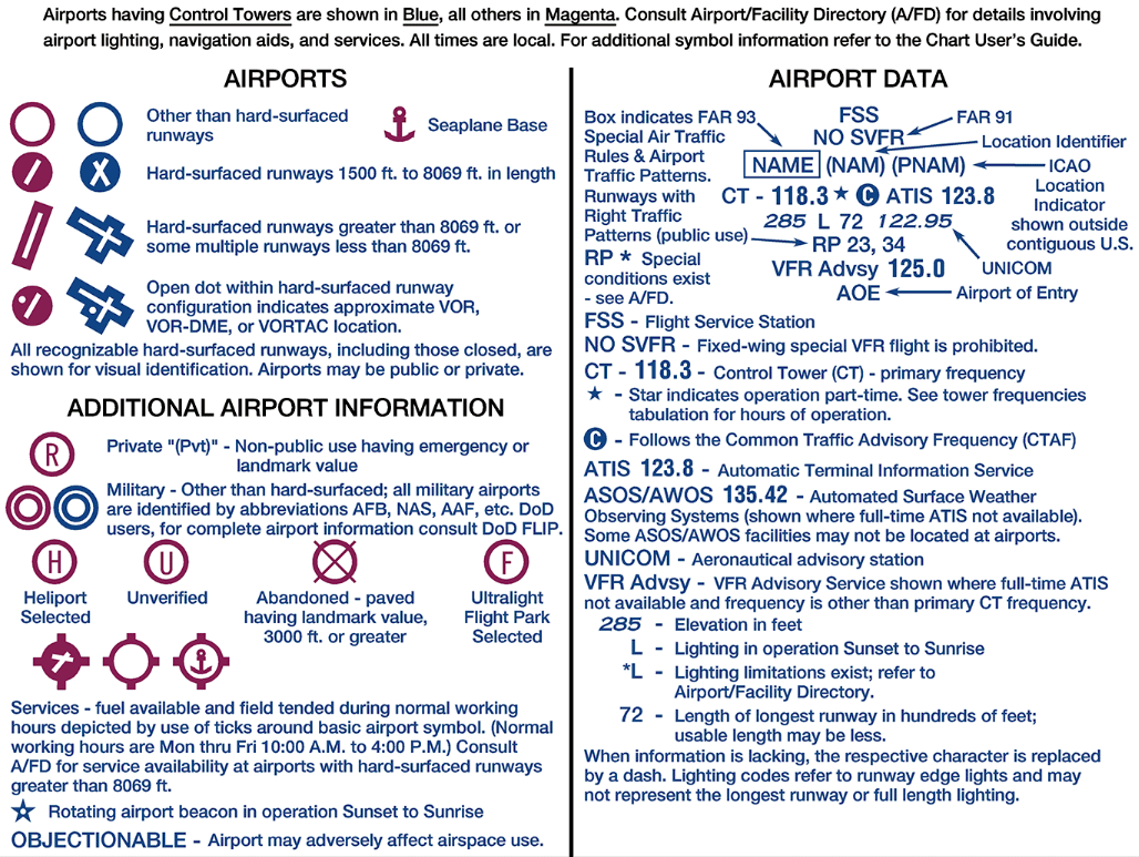
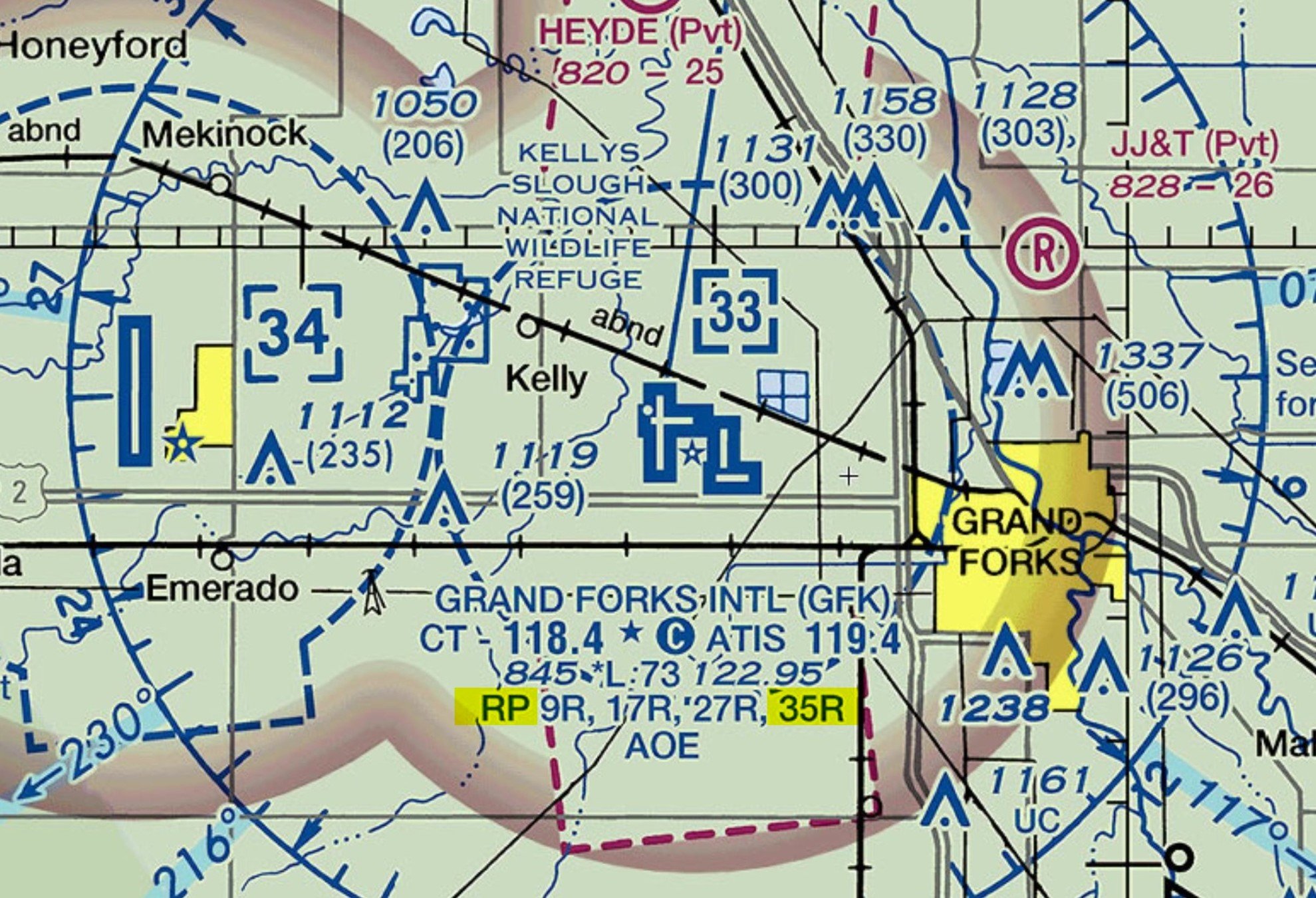
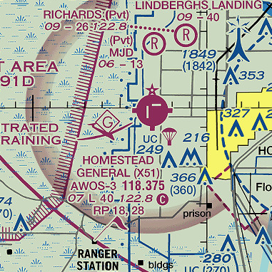
Airport Symbols and Data
Indicates that runway lights are on from dusk to dawn
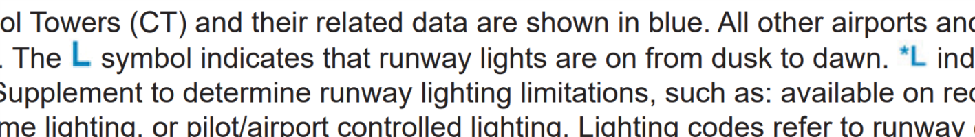
Indicates that the pilot must consult the Chart Supplement to determine runway lighting limitations, such as: available on request (by radio-call, letter, phone, etc.), part-time lighting, or pilot/airport controlled lighting
Indicates the existence of a rotating or flashing airport beacon operating from dusk to dawn. The Aeronautical Information Manual (AIM) thoroughly explains the types and uses of airport lighting aids
Right traffic information is shown using the abbreviation 'RP' for the right pattern, followed by the appropriate runway number(s).
For example: RP 35 = Right traffic pattern for runway 35.
Navigation Aids
Topographical Information
Charts are generally checked every four years. This review includes checking for any obstruction that has been recently built, altered, or dismantled without proper notification.
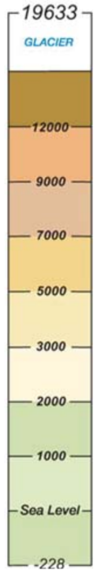
When a natural terrain feature or natural vertical obstacle (e.g., a tree) is the highest feature within the quadrangle:
-
Determine the elevation of the feature.
-
Add the possible vertical error of the source to the above figure (100’ or 1/2 the contour interval when interval on source exceeds 200’).
-
Add a 200’ allowance for uncharted natural or manmade obstacles. Chart specifications don’t require the portrayal of obstacles below minimum height.
- Round the figure up to the next highest hundred-foot level
Example:
- Elevation of obstacle top (MSL) 13,161'
- Possible vertical error +100'
- Obstacle Allowance +200'
- equals 13,461
- Raise to the following 100’ level 13,500'
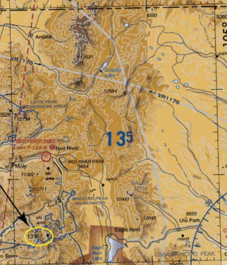
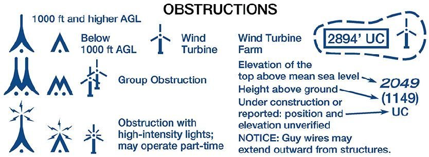
The Maximum Elevation Figure (MEF) represents the highest elevation within a quadrant, including terrain and other vertical obstacles (towers, trees, etc.).

Obstructions
Airspace
Airspace Classifications
- The portion of the atmosphere above a particular land area, especially above a nation.
- FAA provides the safest and most efficient airspace system in the world.
Categories
-
Regulatory
-
Non-Regulatory
Within these two categories, there are four types: controlled, uncontrolled, special use, and other airspaces.
Controlled and Uncontrolled Airspace
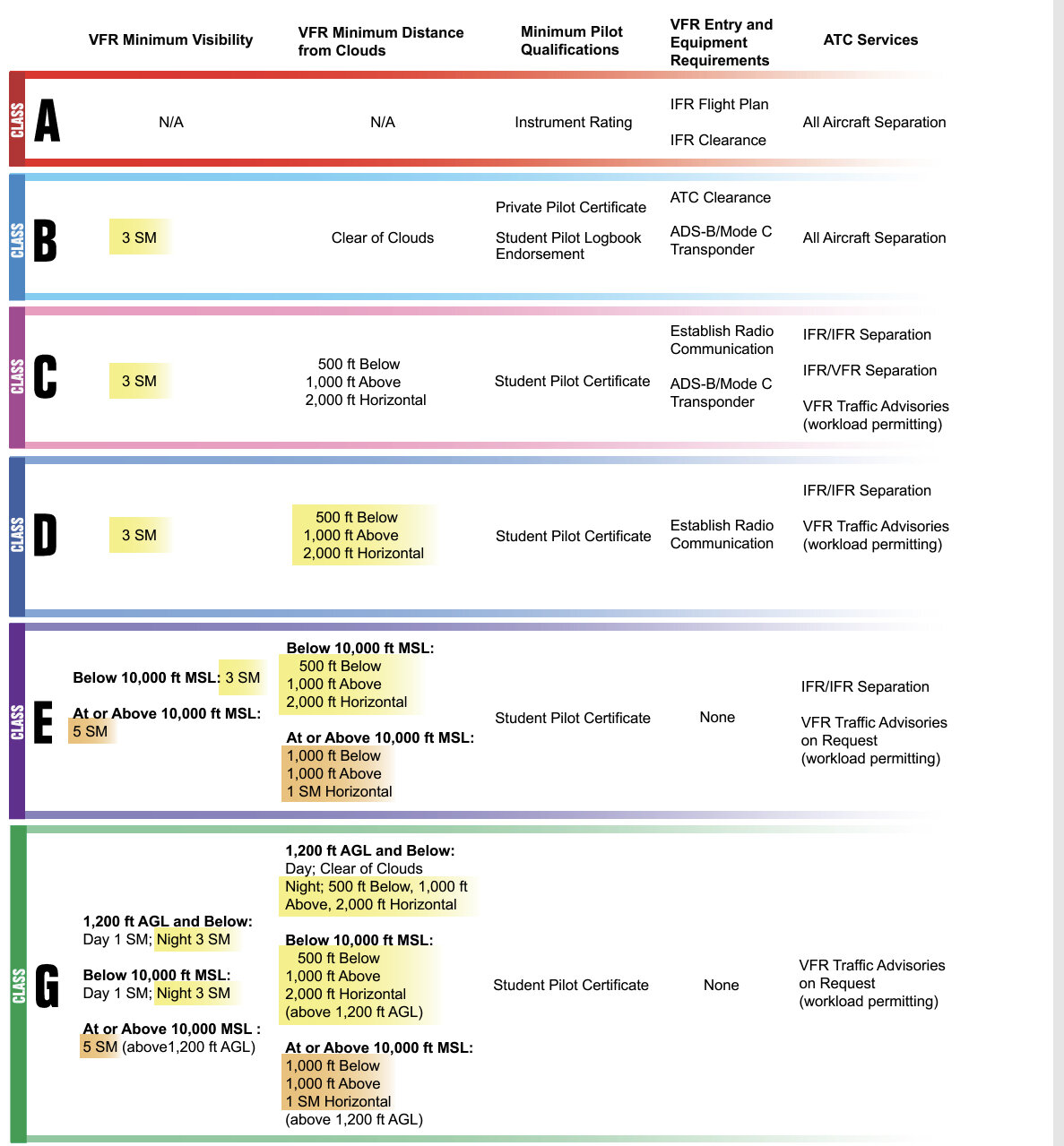
- Controlled Airspace: you are subject to certain operating rules, as well as pilot qualifications and aircraft equipment requirements.
- Uncontrolled Airspace: Although ATC has no authority or responsibility to control air traffic in this airspace, pilots should remember there are visual flight rules (VFR) minimums which apply to Class G airspace.
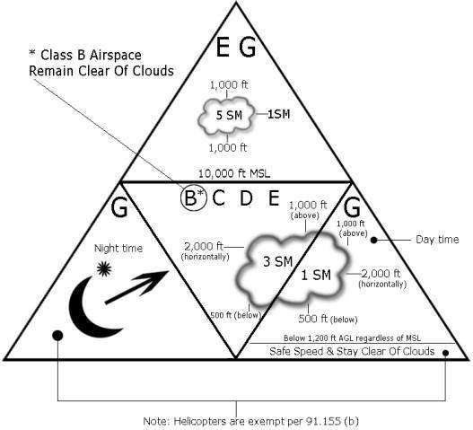
Class G
-
Class G airspace extends from the surface, up to the base of the overlying Class E airspace, normally 700ft or 1,200ft AGL
- In a few areas of the Western U.S., Glass G can extend up to 14,500ft MSL.
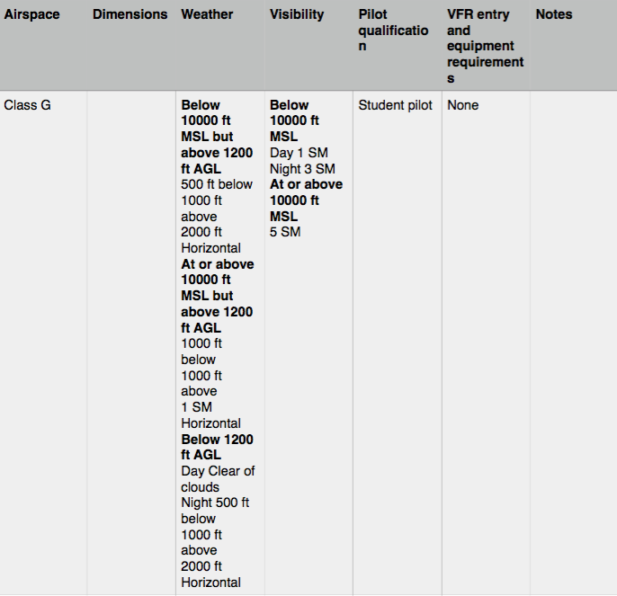
Controlled Airspace
The important thing to know about operating in controlled airspace is that you may be subject to air traffic control. Controlled airspaces consist of :
Class E airspace extends upward from either the surface or a designated altitude to the overlying or adjacent controlled airspace. Up to but not including FL180.
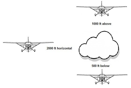
Weather Requirements: 3 SM visibility, cloud clearance of 500' below 1,000' above. and 2,000' horizontal.
Equipment Requirements: ADS-B OUT at or above 10,000' MSL. Excluding at and below 2,500' AGL.
Surface
Transition
Transition
Off-Shore
Federal Airways
Class D
- SFC to 2,500' MSL.
-
Establish two-way communications to enter the airspace.
-
VFR weather: 3 SM visibility; cloud clearance 500' ft below 1,000' above 2,000' horizontal.
-
Speed limit 200 KIAS within 2,500' AGL and 4 NM of the primary airport.
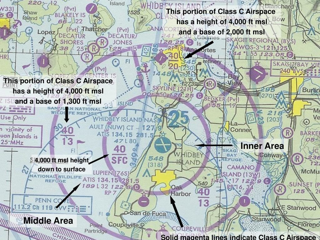
Class C
- SFC to 4,000' MSL. 10 NM radius. Outer area for communications 20 NM.
- Establish two-way communications to enter the airspace.
- VFR weather: 3 SM visibility; cloud clearance 500' below 1,000' above 2,000' horizontal.
- Speed limit 200 KIAS within 2,500' AGL and 4 NM of the primary airport.
- Mode C Transponder and ADS-B OUT required
Click Here for more
Class B
- SFC to 10,000' MSL surrounding busiest airports.
- Clearance Required to enter the airspace.
- Must hold private pilot certificate or student pilot certificate with the required endorsement. TIP: Some airports won't allow student pilots (AIM 3-2-3).
- VFR Weather: Visibility 3 SM, remain clear of clouds.
- Mode C Transponder and ADS-B OUT.
- Speed Limit 250 KIAS below 10,000' ( 200 KIAS below or in VFR corridors)
Solid Blue
Class A
- All airspace from 18,000 ft MSL (FL180) up to and including (FL600) within the 48 contiguous States and within 12 NM offshore.
- ALL aircraft must be IFR unless otherwise authorized.
- No minimun Flight Visibility or distance from clouds is specified.
- Altimeter setting for all aircraft 29.92
- ADS-B OUT required
Let's review
Where is ADS-B OUT required?
The FAA requires ADS-B Out capabilities in the continental United States, in the ADS-B rule airspaces designated by FAR 91.225:
- Class A, B, and C airspace;
- Class E airspace at or above 10,000' MSL. Excluding at and below 2,500' AGL;
- Within 30 NM of a Class B airport (the Mode C veil);
- Above & below Class B or Class C airspace up to 10,000';
- Class E airspace over the Gulf of Mexico, at and above 3,000' MSL, within 12 NM of the U.S. coast.
- Click on this symbol to reveal the answer

- List all the airspace types that exist at the location of the symbol, from the surface up to Flight Level 600 (FL600).
Test your knowledge
Golf: SFC-699ft AGL
Echo Transition: 700ft AGL -3,499ft MSL
Bravo: 4,000ft MSL -12,500ft MSL
Echo Transition: 12,501ft MSL- 17,999ft MSL
Alpha: FL180-FL600
Golf: SFC-1,200ft AGL
Echo Domestic: 1,200ft AGL-2,999ft MSL
Bravo: 3,000ft MSL-12,500ft MSL
Echo Domestic: 12,501ft MSL - 17,999ft MSL
Alpha: FL180-FL600
Bravo: SFC-12,500ft MSL
Echo Transition: 12,501ft MSL - 17,999ft MSL
Alpha: FL180-FL600
Echo SFC: SFC-17,999ft MSL
Alpha: FL180-FL600
Golf: SFC-699ft AGL
Echo Transition: 699ft AGL-17,999ft MSL
Alpha: FL180-FL600
Special VFR
- When the weather is below these VFR minimums, and there is no conflicting IFR traffic, a special VFR clearance may be obtained from the ATC facility having jurisdiction over the affected airspace.
- A special VFR clearance may allow you to enter, leave, or operate within most Class D and Class E surface areas and some Class B and Class C surface areas if the flight visibility is at least one statute mile and you can remain clear of clouds.
Airspeed Limitations
- Flights below 10,000' MSL are limited to a maximum indicated airspeed of 250 KIAS
-
Airspace underlying Class B and in VFR corridors through Class B
- Class C or D airspace or below 2,500' above the surface, and within 4 NM from primary airport
-
There is a 200 KIAS restriction for:
Airspeed Limitations
Special Use Airspace
(AIM 3-4-1)
Special use airspace or special area of operation (SAO) is the designation for airspace in which certain activities must be confined, or where limitations may be imposed on aircraft operations that are not part of those activities.
- Prohibited Areas
Special use airspace usually consists of:
- Restricted Areas
- Controlled Firing Areas (CFA)
- Alert Areas
- Military Operation Areas (MOA)
- Warning Areas
Warning Areas
- Are similar in nature to restricted areas
- Extending from 3 NM outward from the coast of the United States.
- A warning area is and airspace of defined dimensions
- Warning Areas contain activity that may be hazardous to nonparticipating aircraft.
- The airspace is designated with a “W” followed by a number.
- A warning area may be located over domestic or international waters, or both.
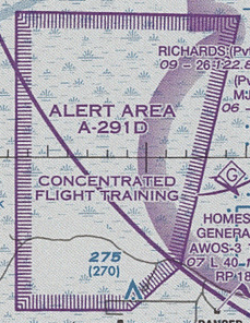
Alert Areas
- Are depicted on aeronautical charts with an “A”
- Alert Areas inform nonparticipating pilots of areas that may contain a high volume of pilot training or an unusual type of aerial activity.
- Pilots should exercise caution in alert areas.
Restricted Areas
- Areas where operations are hazardous to nonparticipating aircraft.
- Restricted areas denote the existence of unusual, often invisible, hazards to aircraft (e.g., artillery firing, aerial gunnery, or guided missiles).
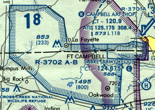
- When Restricted Areas are:
- Not active, they allow the aircraft to operate in the restricted airspace without issuing specific clearance for it.
- Active, the ATC facility issues a clearance which ensures the aircraft avoids the restricted airspace.
Military Operation Areas
(MOA)
- A block of airspace in which military training and other military maneuvers are conducted.
- Exercise extreme caution when military training activity is being conducted.
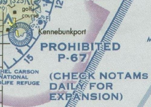
Prohibited Areas
-
Contain airspace of defined dimensions within which the flight of aircraft is prohibited.
- The area is charted as a “P” followed by a number (e.g., P-40).
Controlled Firing Areas
- Controlled firing areas are not depicted on aeronautical charts.
- Its activities are discontinued immediately when a spotter aircraft, radar, or ground facility detects an entering aircraft.
National Security Areas
National Security Areas (NSAs) are established at locations where there is a requirement for increased security and safety of ground facilities. Flight in NSAs may be temporarily prohibited to provide a greater level of security and safety. A NOTAM is issued to advise you of any changes in an NSA’s status.
Other Airspace
(AIM 3-5-1)
Other airspaces typically do not have the same types of restrictions or hazardous activities as Special Use Airspaces.
-
Local Airport Adivory Areas
-
Military Training Routes
-
Published VFR Routes
-
Parachute Jumping Aircraft Operations
-
Terminal Radar Service Areas
-
Temporary Flight Restrictions
Other Airspaces consist of:
Local Airport Advisory (LAA)
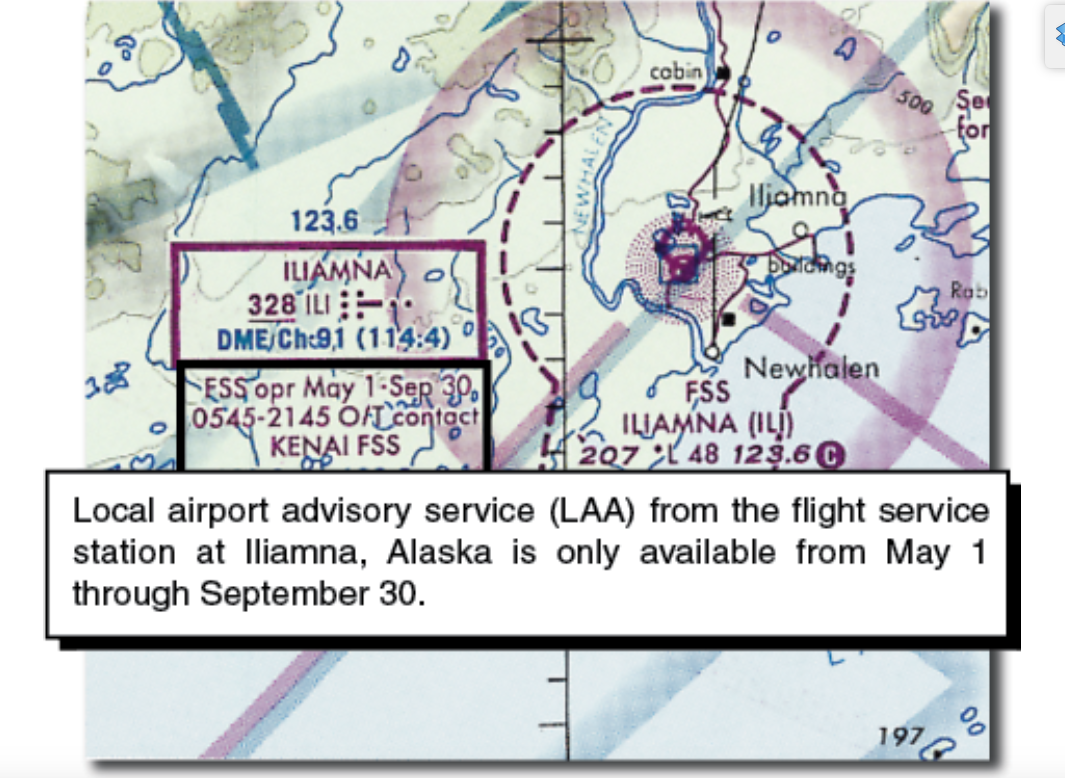
Local Airport Advisory (LAA) is a service provided by FSS facilities, which are located on the landing airport, have a discrete ground-to-air communications frequency or the tower frequency when the tower is closed, automated weather reporting with voice broadcasting, and a continuous ASOS/AWOS data display, other continuous direct reading instruments, or manual observations available to the specialist. Participation in the program is not mandatory but is encouraged. Safety is enhanced when everyone participates.
Military Training Routes
(MTRs)
- MTRs with no segments above 1,500' AGL are identified by numbers, like IR618 or VR618.
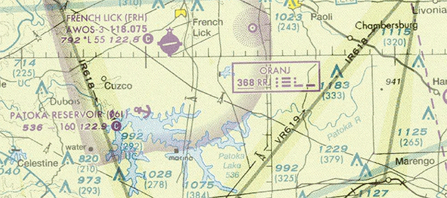
- MTRs are routes used by military aircraft to maintain proficiency in tactical flying.
Published VFR Routes
Published VFR routes are for transitioning around, under, or through some complex airspaces.
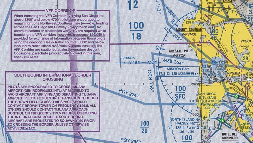
Parachute Jump Aircraft Operations
Parachute jump aircraft operations are published in the Chart Supplement (A/FD). Airports/sites that are used frequently are depicted on sectional charts.

Terminal Radar Service Areas
(TRSAs)
Depicted on VFR sectional charts with a solid black line.
- The purpose of the service is to provide separation between all IFR operations and participating VFR aircraft.
- TRSAs are areas where participating pilots can receive additional radar services.
Temporary Flight Restrictions (TFR)
- TFRs are regulatory actions that temporarily restrict certain aircraft from operating within a defined area in order to protect persons or property in the air or on the ground.
- A flight data center (FDC) Notice to Airmen (NOTAM) is issued to designate a TFR.
- The NOTAM begins with the phrase “FLIGHT RESTRICTIONS” followed by the location of the temporary restriction, effective time period, area defined in statute miles, and altitudes affected.
- Environmental Disaster
- Protect the President, Vice President, or another public figure.
- Provide a safe environment for space agency operations.
- Aerial Show / Big Event
- High Barometric Pressure (greater than 31.00" Hg)
Some of the purposes for establishing a TFR are:
Air Defense Identification Zone
(ADIZ)
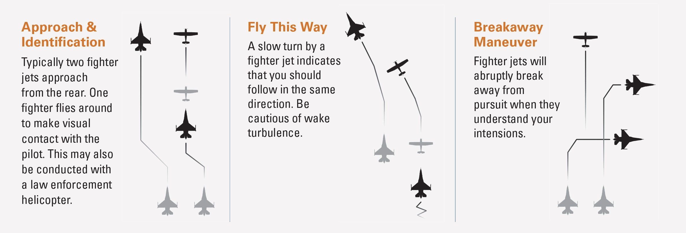
- Failure to follow these rules may result in your aircraft being intercepted by U.S. security.
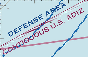
- Have an operating transponder with Mode C capability and a two-way radio to make periodic position reports.
- Air Defense Identification Zones (ADIZs) are established to facilitate the identification the vicinity of U.S. international airspace boundaries.
- Generally, you must file an IFR or defense VFR (DVFR) flight plan for all operations that enter or exit an ADIZ.
Washington DC Special Flight Rules Areas (SFRA)
- After the September 11th terrorist attacks, security authorities established the Washington DC Air Defense Identification Zone – the ADIZ – and the Flight Restricted Zone – the FRZ -- to protect the nation’s capital.
- Airspace is monitored very closely
- Serious consequences for violation
- Course required to ensure that pilots understand requirements and procedures
- The course is a one-time-only requirement
- Good idea to review periodically
- Always check the NOTAMS
- SFRA is depicted on charts and includes all airspaces within 30 NM radius, and up to FL180
- Identification, location, and control of aircraft is required in the interest of national security.
Interception Procedures
Use of 121.5 for communication if not on ATC frequency already