GL 7 Meteorology

Rev 11/2024
Disclaimer
Students should use their textbooks, syllabus, and Airman Certification Standards (ACS) as their primary sources of information. EcFlight is an online training tool designed to simplify and enhance your ground school learning experience. However, it is not a substitute for FAA- or school-approved study materials. Before using these slides for study, always refer to your officially approved resources, such as the Jeppesen physical or electronic book and other FAA-approved materials.
Objectives
This image is based on the Jeppesen Private Pilot Syllabus 2024 (PrivatePilotSyllabus_eBook_10464404-003, n.d.). It is used in compliance with the Part 141 program at ADF Airways.
Reference Books
- Pilot's Handbook of Aeronautical Knowledge (FAA-H-8083-25B). (2016). Oklahoma City, OK: United States Department of Transportation, Federal Aviation Administration, Airman Testing Standards Branch.
-
Aviation Weather Services: FAA-AC00-45H (FAA Handbooks Series) (2016). Oklahoma City, OK: United States Department of Transportation, Federal Aviation Administration, Airman Testing Standards Branch.
- Private Pilot Syllabus (10001292-002). (2012). Englewood, CO: Jeppesen.
- Ehrenberg, M. (2018, November 25). Near record heat followed by a cold front. Retrieved from https://cbs12.com/news/local/near-record-heat-followed-by-a-cold-front
- Met Office - Learn About Weather. (2018). What is global circulation? | Part Three | The Coriolis effect & winds. YouTube. https://www.youtube.com/watch?v=PDEcAxfSYaI&t=44s
Reference Multimedia
Index
Section A - Basic Weather Theory

Section B - Weather Patterns
Section C - Weather Hazards
Basic Weather Theory
What is Weather?
Weather is a state of the atmosphere, to the degree that it is hot or cold, wet or dry, calm or stormy, clear or cloudy.
The Atmosphere
- A blanket of air is made up of a mixture of gases surrounding the earth.
- Without the atmosphere, no clouds, oceans, or protection from the sun's intense rays would exist. This blanket is essential for living on earth.
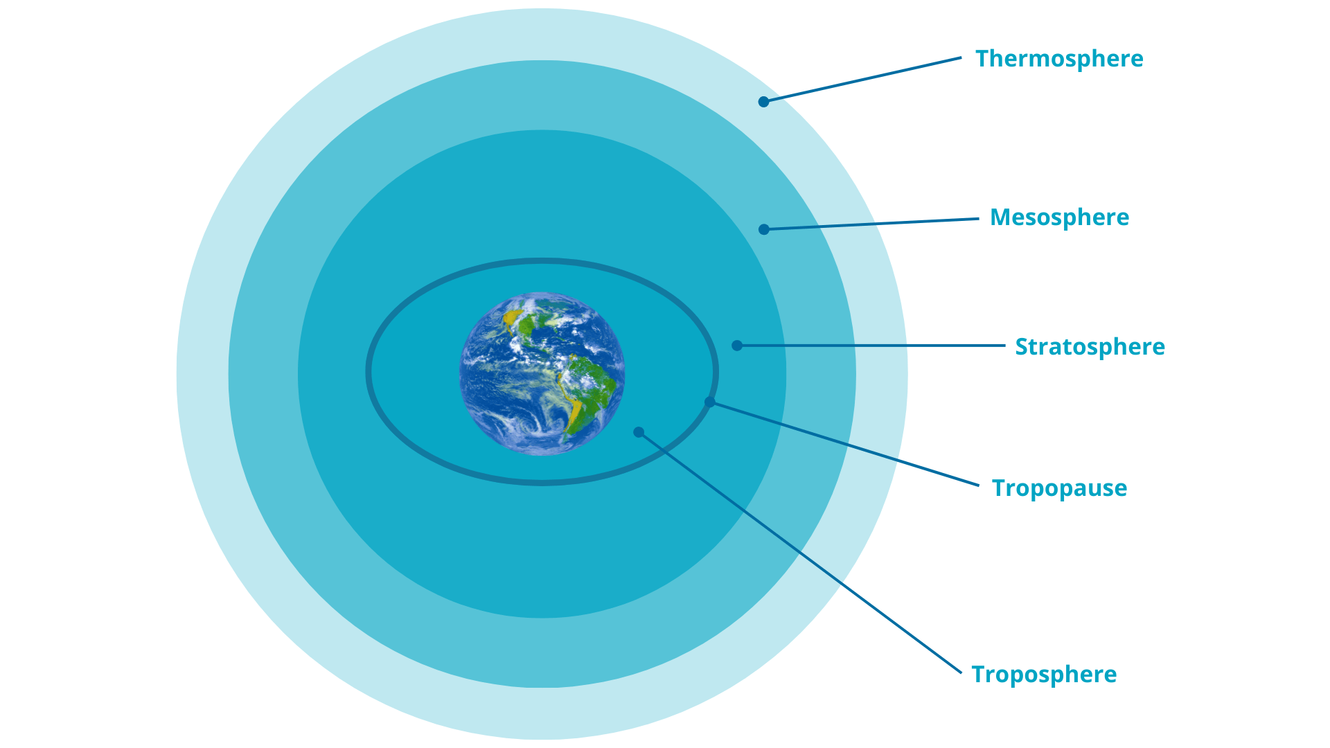
Atmospheric Levels
Composition of the Atmosphere
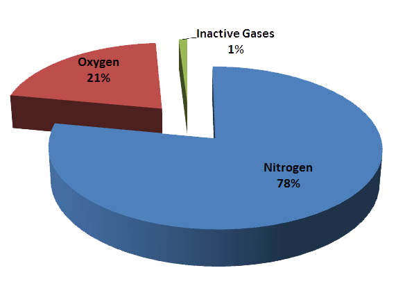
Water vapor 0% to 4%
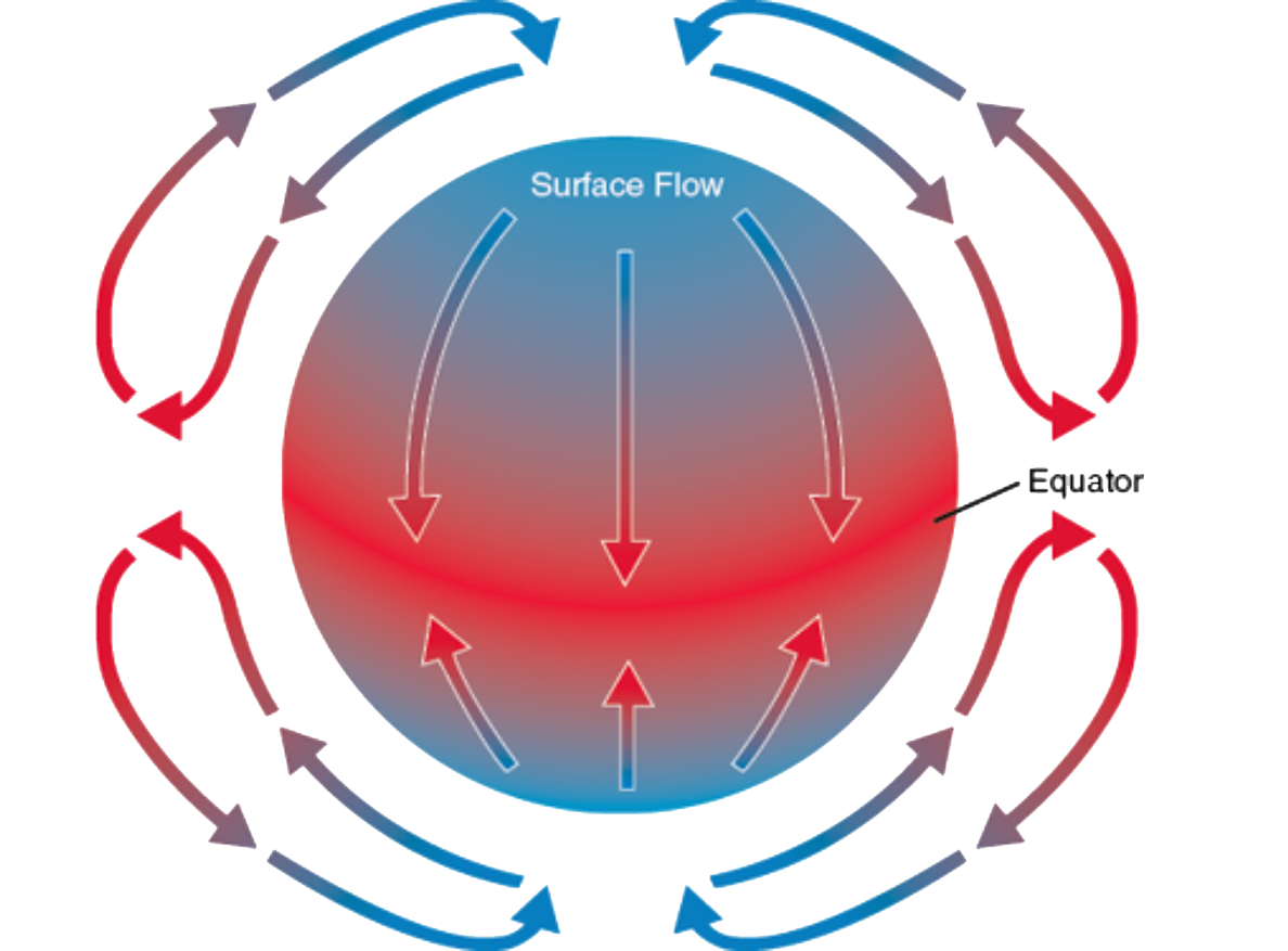
Atmospheric Circulation
Atmospheric Circulation
- The atmosphere is in constant motion
- The primary factor uneven heating of the earth surface.
- Earth is warmed by the energy radiating from the sun.
Temperature
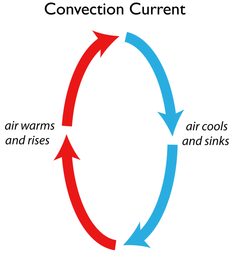
Convection
-
Warm air rises because heat causes air molecules to spread apart. As air expands, it became less dense and lighter.
- As the air cools, the molecules pack together more closely, became heavier and denser than warm air. As result, cool, heavy air tend to sink and replaced warmer
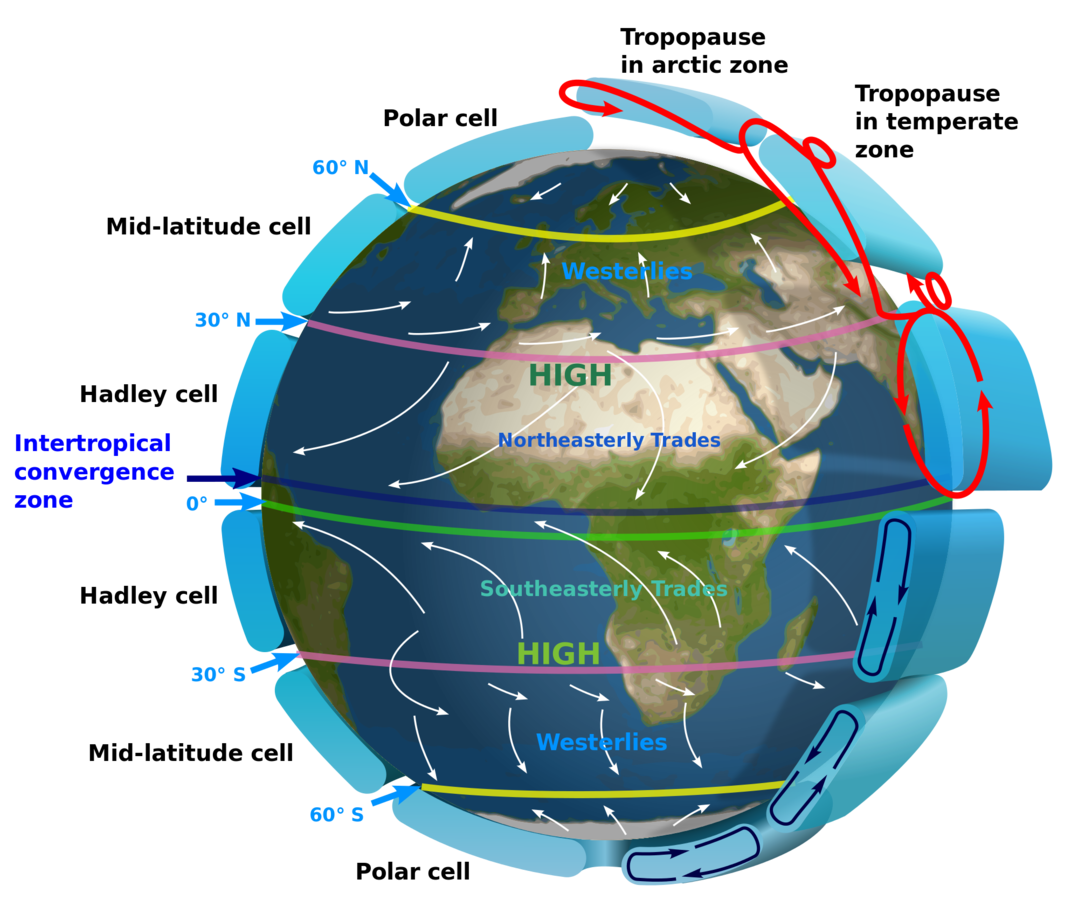
Three Cell Circulation Pattern
As the earth rotates, the single-cell circulation breaks up into three cells. The air still rises at the equator and flows toward the poles aloft, but that branch of the circulation reaches only about 30° latitude where the air sinks
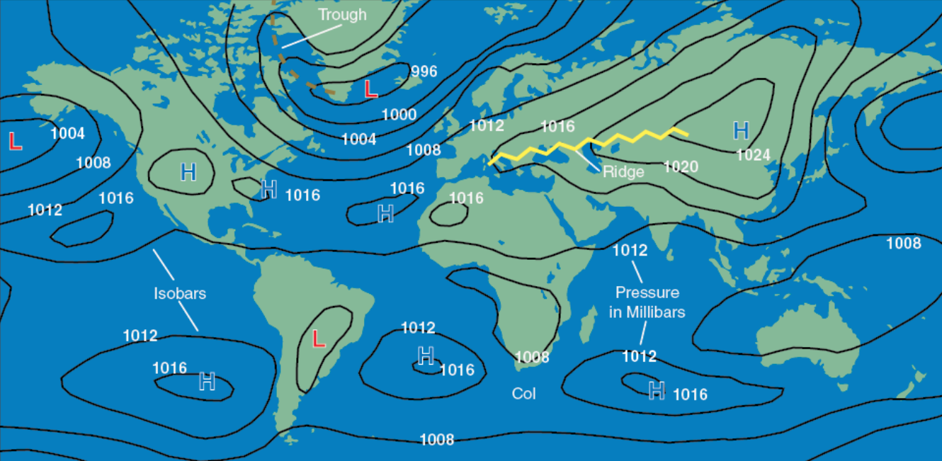
Atmospheric Pressure
-
The unequal heating of the surface not only modifies air density and creates circulation patterns, it also causes changes in pressure.
- This is one of the main reasons for differences in altimeter settings between weather reporting stations
High - center of high pressure surrounded on all sides by lower pressure.
Ridge - elongated area of high pressure
Low - area of low pressure surrounded by higher pressure.
Trough - elongated area of low pressure
Col - Neutral area between two high or low pressure.
Coriolis Force
- The force created by the rotation of the earth is known as the Coriolis force.
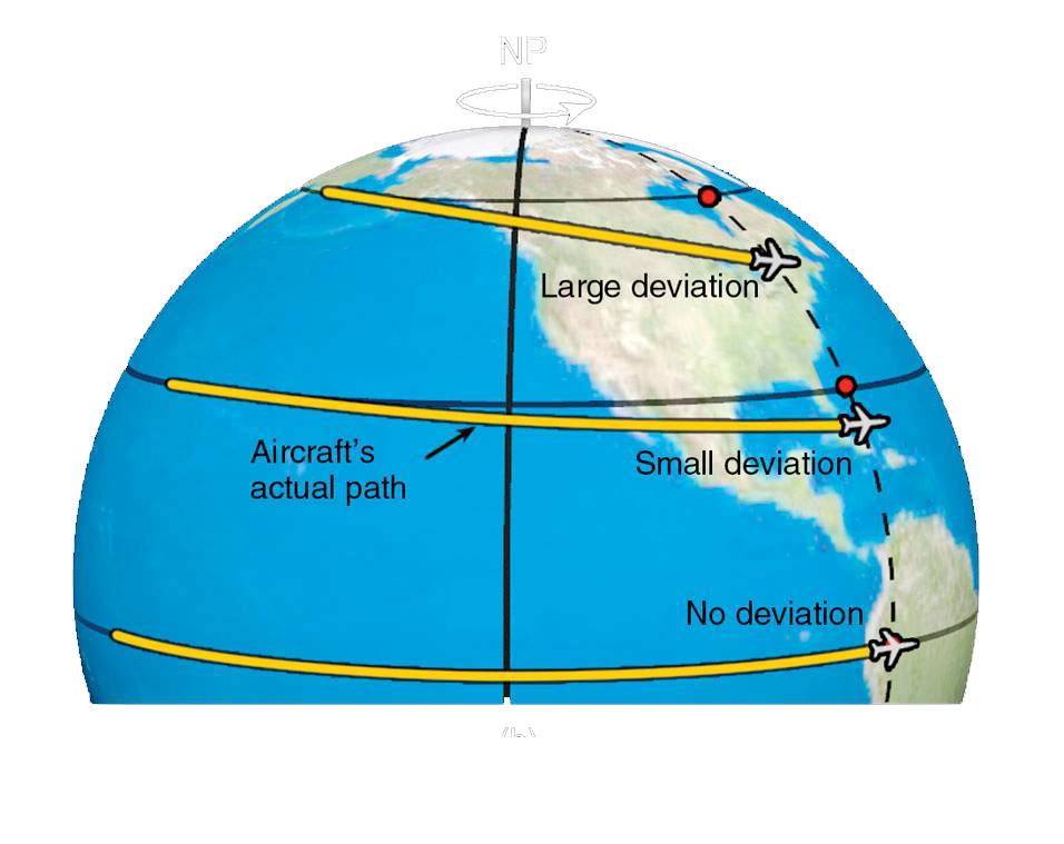
- Not perceptible to humans as they walk around because humans move slowly and travel relatively short distances compared to the size and rotation rate of the Earth. However, it affects the body that moves a greater distance.
- Coriolis force causes all free-moving objects to trace a curved path due to the earth's rotation. In the northern hemisphere, the deviation will be to the right of its intended path while the opposite will occur in the southern hemisphere.
Frictional Force
- Pressure gradient and Coriolis forces work in combination to create wind. Pressure gradient force causes air to move from high-pressure areas to low-pressure areas.
- As the air begins to move, Coriolis force deflects it to the right in the northern hemisphere.
- However, within about 2,000 feet of the ground, friction caused by the earth’s surface slows the moving air.
- Friction causes the wind to shift directions when near the earth’s surface.
Global Wind Patterns
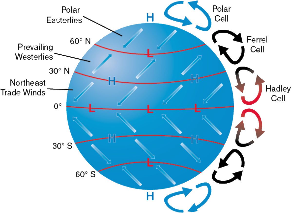
Global winds do not move directly from north to south nor south to north due to Earth's rotation. All winds in the Northern Hemisphere appear to curve to right as they move. In the Southern Hemisphere, winds appear to curve to the left.
Local Wind Patterns
These wind patterns are caused by terrain variations such as mountains, valleys, and water.
Sea Breeze
Since land surfaces warm or cool more rapidly than water surfaces, land is usually warmer than water during the day. This creates the sea breeze, which is a wind that blows from cool water to warmer land.
Land Breeze
At night, land cools faster than water, and a land breeze blows from the cooler land to the warmer water.
Valley Breeze
As mountain slopes are warmed by the sun during the day, the adjacent air also is heated. Since the heated air is less dense than the air at the same altitude over the valley, an upslope flow known as a valley breeze is created.
Mountain Breeze
At night, the high terrain cools off and eventually becomes cooler than the air over the valley. The pressure gradient reverses and a downslope flow, or mountain breeze develops.
Weather Patterns
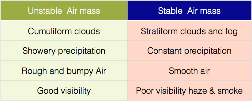
Atmospheric Stability
- Stability is the atmosphere’s resistance to vertical motion. A stable atmosphere does not necessarily prevent air from moving vertically, but it does make that movement more difficult.
- In an unstable atmosphere, convection is the rule. The air rises because it is warmer than its surroundings.
-
Air that moves upward expands due to lower atmospheric pressure. When air moves downward, it is compressed by the increased pressure at lower altitudes.
- As the pressure of air changes, so does its temperature. The temperature change is caused by a process known as adiabatic heating or adiabatic cooling, which is a change in the temperature of dry air during expansion or compression.
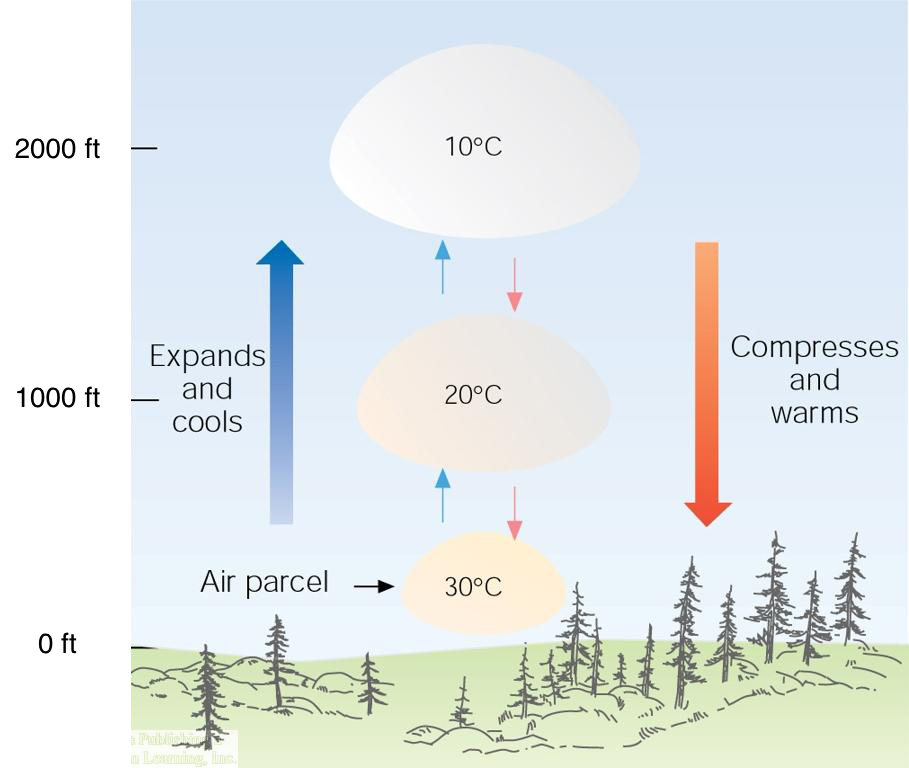
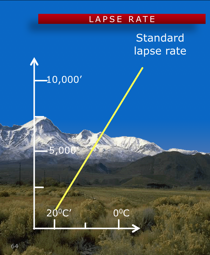
- The rate at which temperature decreases with an increase in altitude is referred to as its lapse rate.
- As you ascend through the atmosphere, the average rate of temperature change is 2°C (3.5°F) per 1,000 feet.
Temperature Inversions
Although temperature usually decreases with an increase in altitude, the reverse is sometimes true. When temperature increases with altitude, a temperature inversion exists.
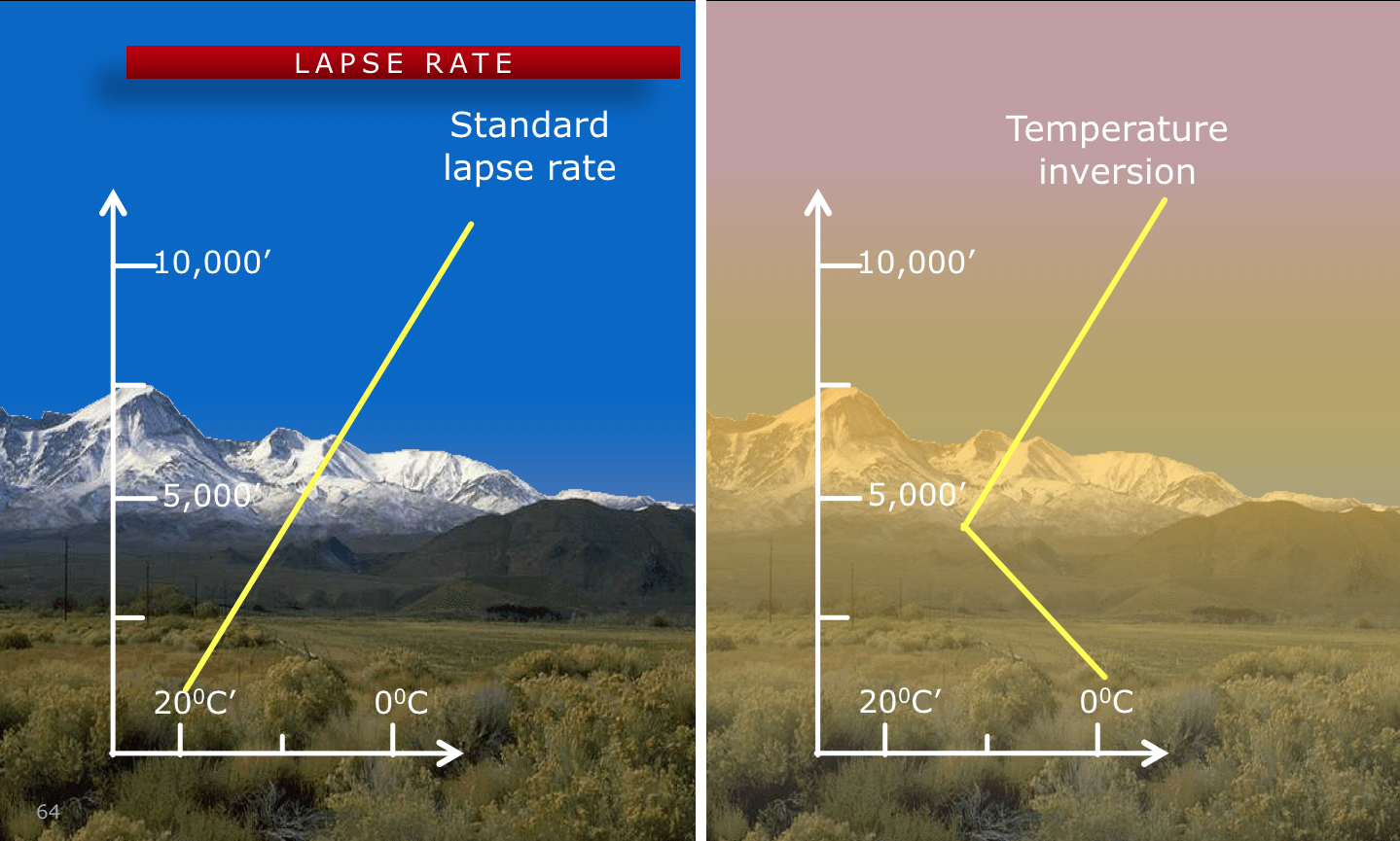
- Below the inversion, visibility is often restricted by fog, haze, smoke, and low clouds.
- Temperature inversions occur in stable air with little or no wind and turbulence.
Moisture
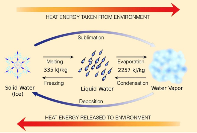
Moisture refers to the presence of a liquid, especially water.
Changes of State
Changes in state occurs through different processes:
- Evaporation
- Condensation
- Sublimation
- Deposition
- Melting
- Freezing
Water is present in the athmosphere in three states: solid, liquid and gas
Humidity
Humidity is the amount of water vapor in the air
Relative humidity
- The actual amount of moisture in the air compared to the total amount that could be at that temperature
Amount of moisture in the air depends on air temperature
Dewpoint
Temperature to which air must be cooled to become saturated and can hold no more water.
- How to calculate cloud bases
Temp ºc – Dewpoint ºc * 1000
2.5 ºc
Dew and Frost
The surface cools to temp below the dewpoint of the surrounding air
- Dew if dewpoint is above freezing – water vapor condenses
- Frost if dewpoint is below freezing – water vapor changes directly to ice
Clouds and Fog
Grouped by families according to altitude
- Low, fog
- Middle
- High
- Clouds with vertical development
Clouds form when the invisible water vapor in the air condenses into visible water droplets or ice crystals. Air must be saturated, so it starts to condense into a liquid or solid form (condensation nuclei).
Low Clouds
- Low clouds extend from near the surface to about 6,500 feet AGL.
- Types of low clouds include stratus, stratocumulus, and nimbostratus.
Stratus
- Layered clouds in stable air near the surface due to cooling from below.
- Covered in a wide area and have a gray appearances
Nimbostratus
-
Clouds with rain appearance
- Can be thick in thousands of feet, and contain a lot of moisture
- The clouds can turn from gray to black
Stratocumulus
- White and puffy clouds because stable air is lifted
- Can expect them as stratus layer breaks up or cumulus clouds spreading out
Fog
- Fog is a low cloud which has its base within 50 feet of the ground.
- Low clouds usually consist almost entirely of water but sometimes may contain supercooled water. If the fog is less than 20 feet deep, it is called ground fog.
- Fog is classified according to the way it forms.
- Radiation fog
- Advection fog
- Upslope fog
- Steam fog
- Precipitation Fog
- Freezing Fog
Radiation fog or ground fog forms on clear, calm, humid nights. Radiation fog usually occurs in stable air associated with a high-pressure system. Temperature inversion is associated with radiation fog.
Advection fog is caused when a low layer of warm, moist air moves over a cooler surface. It can occur over water and land, and can bring turbulence with it.
Upslope fog forms when moist, stable air is forced up a sloping land mass. It causes sinking air to warm and rising air to cool. You will see upslope fog on the mountain's top.
Steam fog, often called sea smoke, occurs as cold, dry air moves over comparatively warmer water, commonly in cold weather months. Low level turbulence may be present in the area.
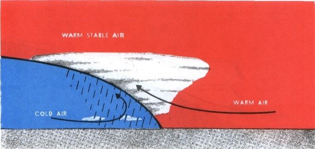
Precipitation fog occurs when warm rain falls through cold air, and it starts to saturate. It is common with warm fronts and slow moving cold fronts.
Freezing fog occurs when the temperature is below freezing, and the tiny droplets of water are supercooled in the air. It will start freezing once the droplets are on contact. Freezing fog is the most dangerous fog.
Middle Clouds
- From about 6,500 to 20,000 feet AGL.
- Composed of water, ice crystals, or supercooled water.
- May contain moderate turbulence and potentially severe icing.
- Altostratus and Altocumulus are classified as middle clouds.
Altostratus
- Flat and dense clouds covered a wide area
- Gray or gray-white in color
- They can contain moderate icing
Altocumulus
-
Gray or white patchy clouds that will appear after altostratus clouds
- Might experience light turbulence and icing enroute
High Clouds
- Beginning above 20,000 feet AGL.
- They are generally white to light gray
- Form in stable air
- Composed mainly of ice crystals and seldom pose a serious turbulence or icing hazard
- The three basic types of high clouds are called cirrus, cirrostratus, and cirrocumulus
Cirrus
These clouds are make up from ice crystals above 30,000 ft
Cirrustratus
- Mostly form in long bands with the blue sky as the background.
- Thin, white clouds
- No icing hazards in these clouds
Cirrocumulus
- White patch clouds that look like cotton
- They are a result of shallow convective currents
- May experience light turbulence

Clouds with Vertical Development
- Vertical cloud development and turbulence result from the lifting of unstable air.
- The three basic types are called cumulus, towering cumulus and cumulonimbus.
Cumulus
Dome-shaped clouds with a flat bottom that look as puffy clouds
Towering
Cumulus
Similar to cumulus clouds except they have more vertical development
Cumulunimbus
- Known as thunderstorms clouds
- Vertically developed clouds that change from gray-white to black in color
- Contain a lot of moisture, turbulence, icing, and lighting
Precipitation
- Water, liquid or solid, that falls from the atmosphere and reaches the ground.
- Whether it reaches the ground or evaporates before it reaches the surface, precipitation contributes to many aviation weather problems.
-
Aviation problems
- Visibility
- Engine performance
- Increased braking distance
- Wind – shift direction, velocity
- Icing
Precipitation Causes
-
There are three ways by which precipitation-size particles can be produced.
- Condensation/Deposition.
- Coalescence
- A more efficient ice-crystal process occurs primarily in the middle to high latitudes where the clouds can extend upward into areas well below freezing.
- For precipitation to occur, water or ice particles must grow in size until they can no longer be supported by the atmosphere.
Types of Precipitation
-
Drizzle and rain
-
Ice pellets and hail
-
Snow
Drizzle and Rain
-
Drizzle is distinguished by tiny droplets (less than 0.02 inches in diameter). It is commonly associated with fog or low stratus clouds. Falling drops of liquid precipitation are considered to be rain when it is 0.02 inches in diameter or greater.
-
Streaks of rain which evaporate before reaching the ground are known as virga.
Ice Pellets and Hail
-
Ice pellets at the surface are an indication of a temperature inversion and freezing rain at a higher altitude.
-
In some cases, water droplets that freeze in clouds, eventually they become too large for air currents to support, and they fall as hail.
Snow
Snow is precipitation composed of ice crystals.
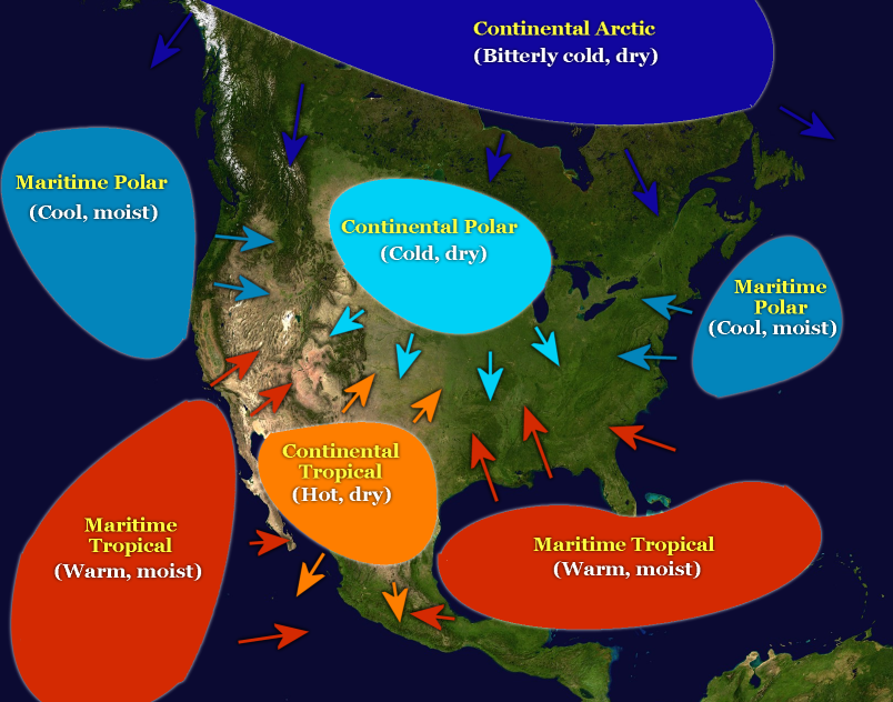
Air Masses
-
An airmass is a large body of air with fairly uniform temperature and moisture content.
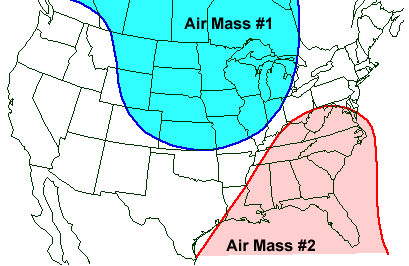
Source region
-
The area where an airmass acquires the properties of temperature and moisture that determine its stability is called its source region.
Classifications
-
Airmasses are classified according to the regions where they originate. They are generally divided into polar or tropical to identify their temperature characteristics, and continental or maritime to identify their moisture content.
Fronts
-
Boundaries between air-masses.
-
Fronts are named according to the temperature of the advancing air relative to the temperature of the air it is replacing.
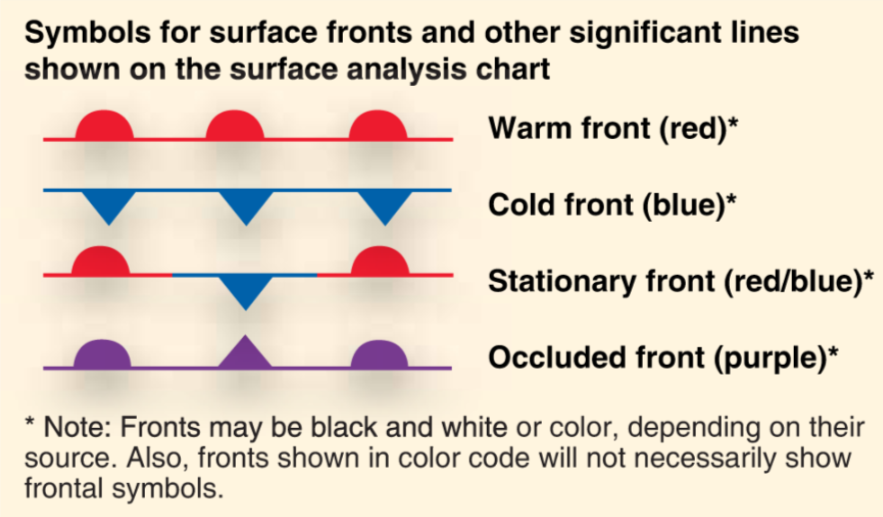
Warm Front
-
A warm front occurs when a warm mass of air advances and replaces a body of colder air. Warm fronts move slowly, typically 10 to 25 miles per hour (mph).
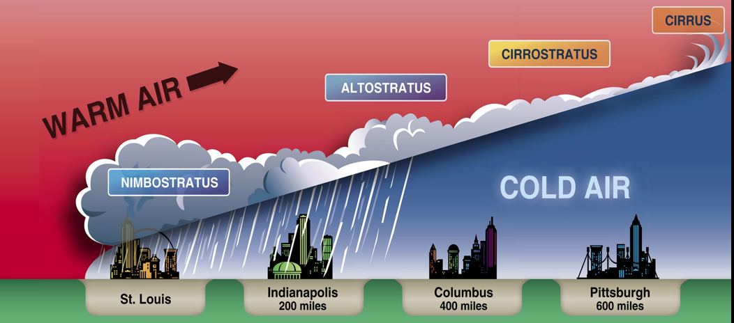
Warm Front

By Jeppesen
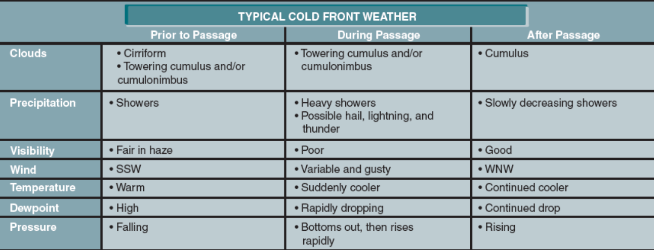
Cold Front
-
A cold front occurs when a mass of cold, dense, and stable air advances and replaces a body of warmer air.
-
Cold fronts move more rapidly than warm fronts, progressing at a rate of 25 to 30 mph
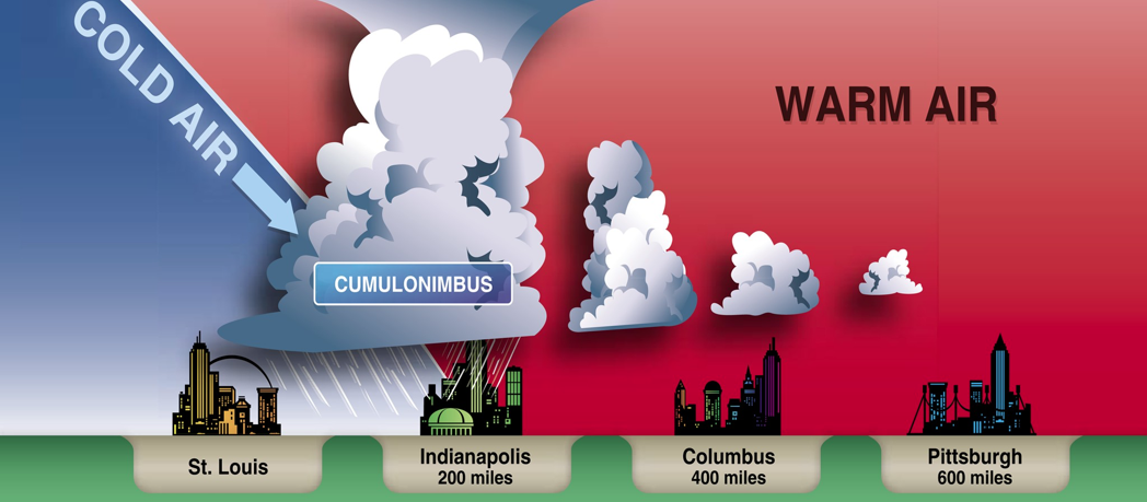
Cold Front
By Jeppesen
Stationary Front
When the forces of two air masses are relatively equal, the boundary or front that separates them remains stationary and influences the local weather for days.
Occluded Front
An occluded front occurs when a fast-moving cold front catches up with a slow-moving warm front. As the occluded front approaches, warm front weather prevails but is immediately followed by cold front weather
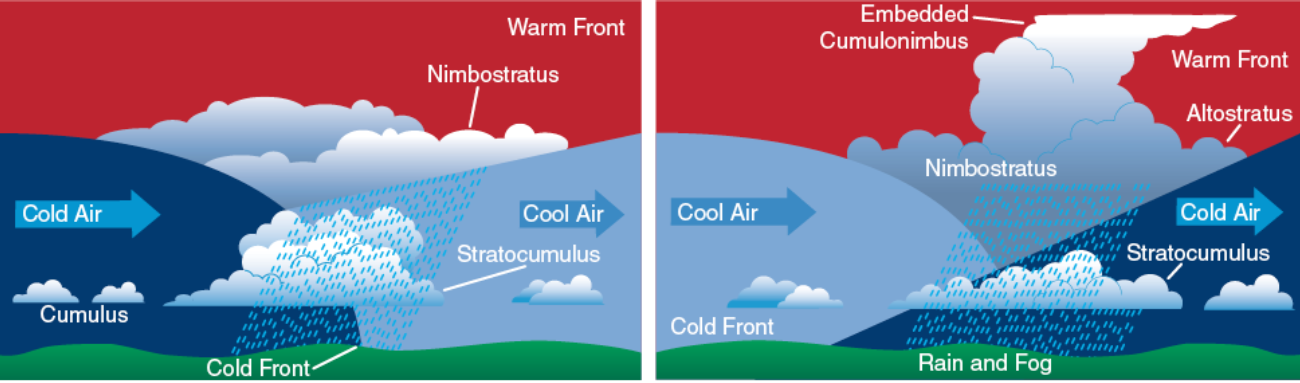
Occluded Front
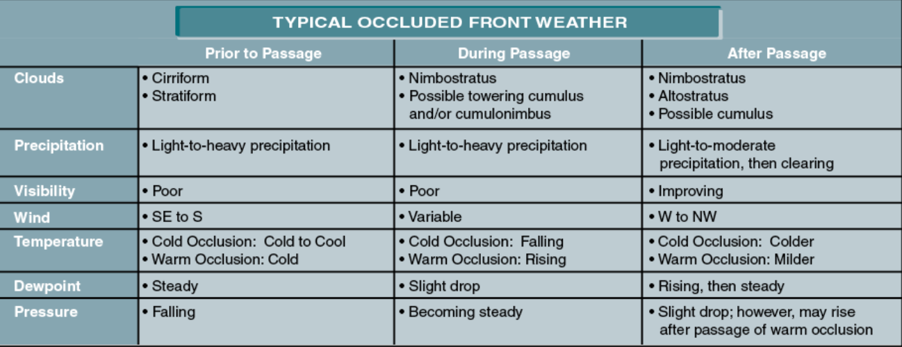
By Jeppesen
Weather Hazards
Thunderstorms
Ingredients of a Thunderstorm:
- Unstable air
- Lifting force
- Visible moisture
Two Types of Thunderstorm
Airmass
- Scattered
- Short-lived
-
Rarely have large hail or strong winds
Severe
- 50 knot winds or more
- Hail ¾ inches diameter
- Tornadoes (funnel clouds)
- Waterspout
May Exist as:
- Single-cell - Less than 1 hour
- Super-cell - May last for 2 hours
- Multi-cell - Cluster of thunderstorm
- Squall Line - is a non-frontal band of thunderstorms
Life Cycle
Thunderstorm Avoidance
- Avoid Thunderstorms by atleast 20 miles.
- ATC cannot keep you out of thunderstorms, but they can advise you of heavy precipitation along your route.
- Don't land or takeoff in the face of an approaching thunderstorm
- Don't attempt to fly under the anvil of a thunderstorm
Turbulence
- Turbulence develops when air currents change direction or velocity rapidly over a short distance. The magnitude of the turbulence depends on the differences between the two air currents.
- In addition to turbulence in and near thunderstorms, three other categories of turbulence affect aviation operations: low-level turbulence, clear air turbulence, and mountain wave turbulence.
Low-level Turbulence
- Defined as turbulence below 15,000 feet MSL
- Originates due to surface heating or friction
- Includes mechanical turbulence, convective turbulence, frontal turbulence, and wake turbulence.
Mechanical Turbulence
-
Obstacles (building, terrain) interfere with normal wind flow
-
Wind forms eddy when it blows around trees, hangars, etc.
-
Produced downwind of obstructions
Convective Turbulence
-
Also referred to as thermal turbulence,
-
Typically a daytime phenomena
-
Occurs over land in fair weather.
-
Caused by currents, or thermals, which develop in air heated by contact with the warm surface below.
-
Towering cumulus clouds indicate presence of convective turbulence.
Frontal Turbulence
-
Occurs in the narrow zone just ahead of a fast-moving cold front where updrafts can reach 1,000 fpm.
-
Generate at least a moderate amount of turbulence.
Clear Air Turbulence
- High altitude phenomenon.
- Usually is encountered above 15,000 feet.
- No visual warning.
- Can be present in non-convective clouds.
- Often develop near to a jetstream.
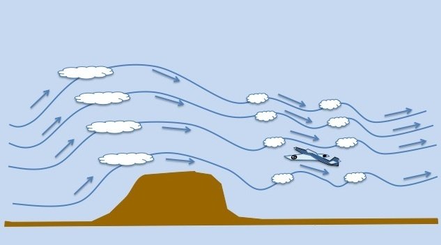
Mountain Wave Turbulence
- Occurs when stable air crosses a mountain barrier.
- Mountain wave turbulence is possible as the stable air moves across a ridge and the wind is 40 knots or greater.
- Create violent turbulence.
- A rotor cloud (sometimes called a roll cloud) may form in the rotors.
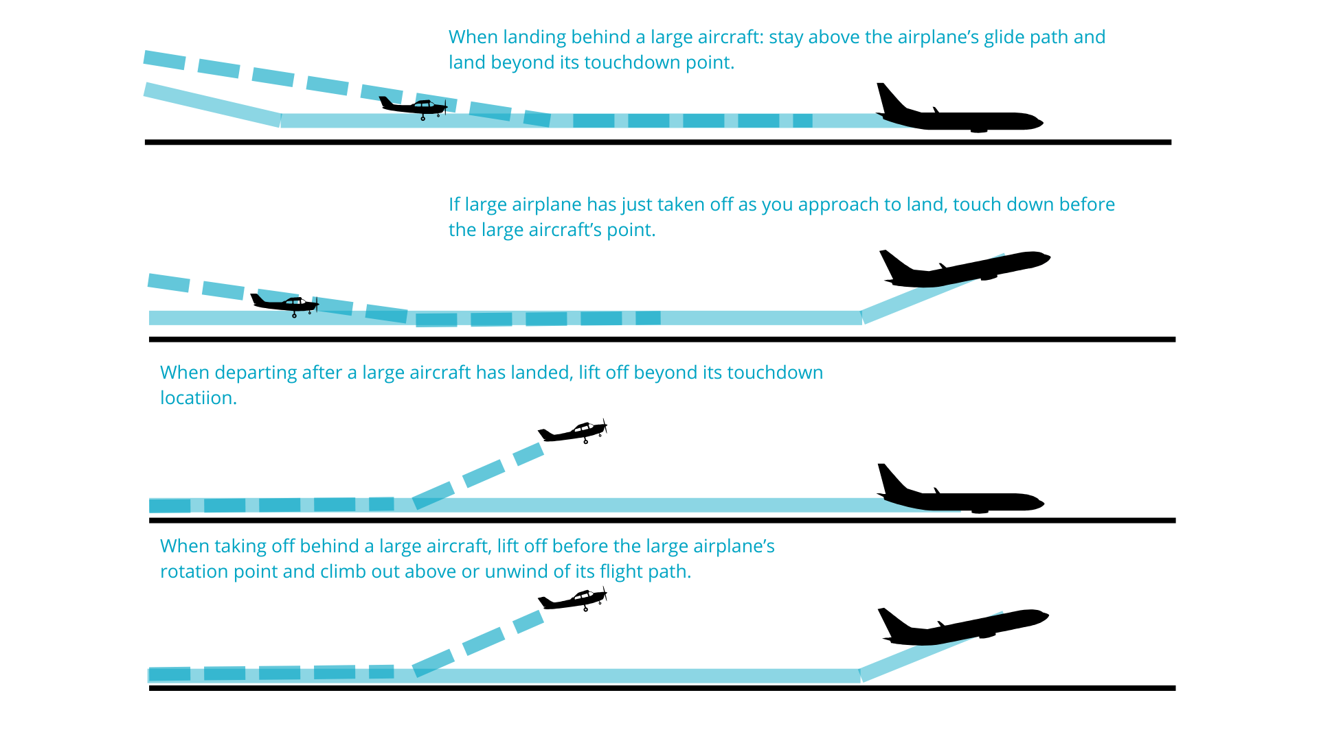
Wake Turbulence
-
Wingtip vortices created when lift is generated
-
Intensity depends on
-
Aircraft weight
-
Speed
- Configuration
-
- Large, heavy aircraft, low speed, high angle of attack = greatest wake turbulence
- Can induce uncontrollable roll rate for small aircrafts.
- Wingtip vortices tend to sink below the flight path of the aircraft which generated them.
Reporting Turbulence
- Light: light changes in altitude and attitude.
- Chop: Rapid bumpiness without an abrupt change in altitude or attitude.
- Moderate: Changes in altitude and attitude but, the aircraft remains in positive control at all times.
- Occasional: Occurs one-third of a given time.
- Intermediate: two-thirds of a given time.
- Continuous: More than two thirds.
Use the following to report turbulence to the respective ATC agency
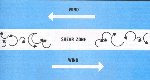
Wind Shear
-
Sudden, drastic shift in speed/direction, in vertical or horizontal plane, any altitude
-
Associated with:
-
Frontal system
-
Thunderstorm
-
Temperature inversion with strong upper-level winds
-
Clear air turbulence
-
Convective precipitation
-
Jet stream
-
-
Some indicator of wind shear:
- Rain shaft
- Virga
- Dust ring on ground
Low-level wind shear alert system (LLWAS)
- LLWAS is a system that is installed at many airports.
- Operate sendings individual anemometer readings every 10 seconds.
- Consult the supplement chart to determine the airports that have LLWAS equipped.
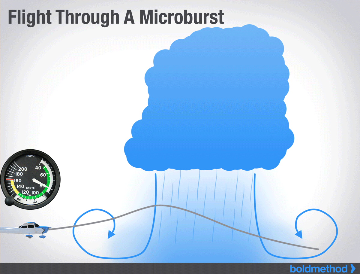
Microburst
-
Strong downdraft, normally occurs horizontal distance 1 NM or less and vertical distance of 1000 ft, Wind greater than 100 knots and downdraft as strong as a 6000 ft/min
-
15 min of life span.
-
Can occur in the mature stage of a thunderstorm
Flying Through a Microburst
-
Increase performance without a change in pitch and power
-
Decrease headwind
-
Downdraft
-
Most Severe Downdraft
-
Strong tailwind Just before contact ground
Icing
We know that there are 3 types of icing
- Structural
- Instrument
- Induction
Structural Icing
-
Ice can build upon any exposed surface of an aircraft during flights in areas of visible moisture when the temperature of the aircraft surface is 0°C or colder.
-
Aircraft are affected by structural ice in a number of ways: thrust is reduced, drag and weight are increased, and the lift is decreased.
-
These effects combine to increase stall speed and reduce overall aircraft performance.
-
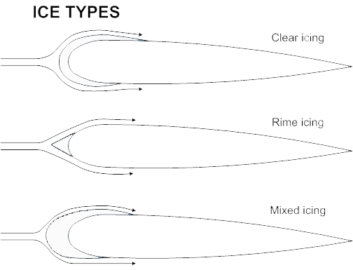
There are 3 type of structural icing: rime, clear, mixed.
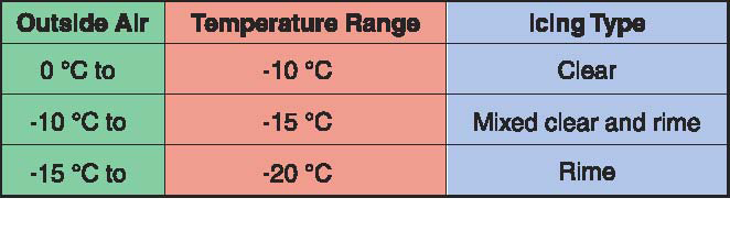
Rime Ice
-
Rime ice normally is encountered in stratus clouds and results from instantaneous freezing of tiny supercooled water droplets striking the aircraft surface. It has an opaque appearance caused by air being trapped in the water droplets as they freeze.
-
Rime ice is particularly hazardous due to its ability to change the shape of an airfoil and destroy its lift
Clear ice
-
Clear ice may develop in areas of large supercooled water droplets which are in cumulus clouds or in freezing rain beneath a warm front inversion. The highest accumulation rate generally occurs in freezing rain. When the droplets flow over the aircraft structure and slowly freeze.
Mixed ice
-
Mixed ice is possible in visible moisture between -10°C and -15°C.
Instrument Icing
Instrument Icing
- The pitot tube and static port heating is also a part of other ice protection systems
- Pitot heat is an anti-ice system on many aircraft uses electricity to heat the pitot tube, and prevent icing formation
Induction Icing
Induction Icing
- The accumulation of ice blocks the venturi, air filter, air intake, and reduces the amount of air available for combustion.
- Most aircraft are equipped with an alternate source of air that brings warm, unfiltered air from to the engine.
- To prevent induction icing, apply carburetor heat.
Lets Review....
Restriction to Visibility
-
Haze – fine dry particles, stable atmosphere, light winds, visibility good above layer
-
Smoke – combustion particles, reddish or orange sky
-
Smog – combo of fog and smoke, stable air and terrain may trap smog and make worse
-
Dust - fine particles of loose soil, strong winds, unstable atmosphere
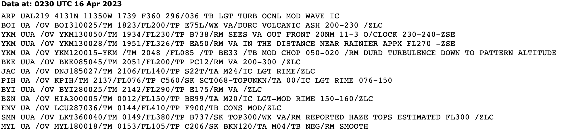
Volcanic Ash
-
Consists of gases, dust, and ash from a volcanic eruption
-
Severe conditions, the ash can clog pitot-static and ventilation systems as well as damage aircraft control surfaces
-
Volcanic ash clouds may be hundreds of miles wide and thousands of feet thick.
Volcanic Ash Avoidance
- Airborne weather radar cannot detect it
- Stay upwind of volcanic ash and dust
- PIREP and/or radar preflight planning