Applied Drone Mapping:
From Collection to GIS Integration
Text
2026 WAGISA Conference, Bellevue, WA
May 19, 2026
Schedule
Part I & II
-
Goal of the workshop
-
Participants
-
Hardware/Software
1
-
Program Development
-
Examples (KC WTD)
-
Example (Lummi Tribe)
2
Introduction
Drone Program
1.1
-
Best Practice
-
Mission Planning
-
Flight Type - 2D/3D
-
Work flow
3
Flight Operation
Text
Sections
Part III
5
1.1
Flight Data Processing
- Imagery Magmt
- Esri Tools
- Data Integration Tools
- Examples (Webmaps, Apps)
6/7
Data Integration
8
Q & A plus
Discussion
Data Processing Software
-
Work flow
-
Software Discussion
Flight Operation (Continue) / Data Processing
-
GCP
-
Photogrammetry
-
Gaussian Splat
-
Lidar
-
Thermal
4
Introduction
-
Name
-
Organization, if there's one
-
Purpose of the workshop
-
Level of understanding & Goal
-
Expectation of the workshop

1.1
RPAS - Remotely Piloted Aircraft System
FAA Definition: Remotely piloted Aircraft system operated by a pilot via ground control or on-board computer.


Background Information
RPAS Categories
Small
- Size: 1 - 2 meters ( 3 ft - 6.5 ft), < 55 lbs.
- Control: Visual line of sight, Radio control
- DJI M3E, M400, ScanEagle
Medium
- Size: Equivalent to a car, ~ 1000 lbs.
Large
- Size: > 30,000 lbs.
Two Spaces for Drone


Outdoor
Indoor
Outdoor
- GPS Signal
- Automated Planning and Flight
- Even, Diffuse lighting
- Open space
Indoor
- No GPS signal
- Limits on speed and motion
- Manual flight control
- Tight spaces
Outdoor
Indoor


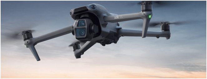
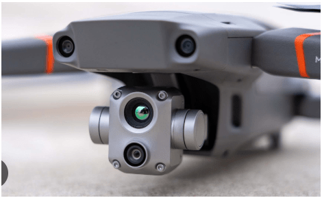
DJI Air & Mavic 2 Pro < $1800
Aertos 120 $25,000 +
Eilos 2 $48,000 +
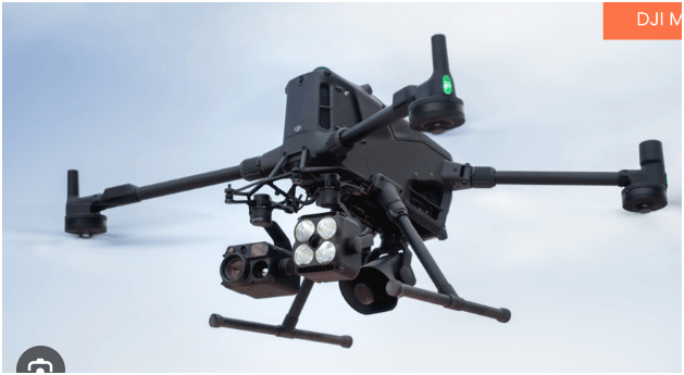
DJI Matrice 300 $12,000 +


RPAS as Platform
Multi-rotors
Fixed-wing & VTOL

- Shorter flight time (< 45 min)
- Cover smaller area
- Highly maneuverable
- Less expensive
- Access to confined spaces
- Long flight time (+ 40min)
- Covers very large area

(vertical take-off & land)

Sensors Payload

Multi-spectral
Thermal Infrared

Lidar Camera

High resolution digital camera (100 MP)

Methane Gas Detector

Sensors Payload
High resolution digital camera


Sensors Payload
LiDAR Sensor - aka Laser Scanning
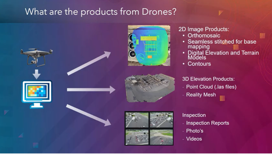
1. Aircraft + Sensor (Data Collection)
2. Data Processing & Analyzing (GIS)
3. Information Products
=
+


1. Platform + Sensor (Data Collection)
2. Data Processing & Analyzing (GIS)
3. Information Products


Standard Drone Workflow


AND

Drone

GIS
Great Combo?
&
Great combo !
GIS & DRONE


Great combo !
GIS & DRONE


FAA Regulations - Where are we now?

Regulations
Commercial/Governmental
FAA Part 107 Rule, July 2016
-
Need FAA Remote Pilot Certification (Pilot license NOT needed)
-
~460,375 - Remote pilots certified (Oct. 2025)
-
433,407 - Commercial Drones Registered (Oct. 2025)
- $175 to take the test
-
Fly under 400 feet above ground level
-
Not to fly < 5 nautical miles around airport
-
Aircraft < 55 lbs.
-
Fly during daytime or night time operation with appropriate lighting
-
Fly visual line of sight ( VLOS)
-
No flight over non-participating people
- ...and many, many more.....
FAA Part 107 Rule
-
Be at least 16 yrs old
-
Pass the initial aeronautical knowledge exam
-
Online recurring training every 24 month
-
Understand recreational flying requirements
-
Take TRUST
-
Online recurring training every 24 month
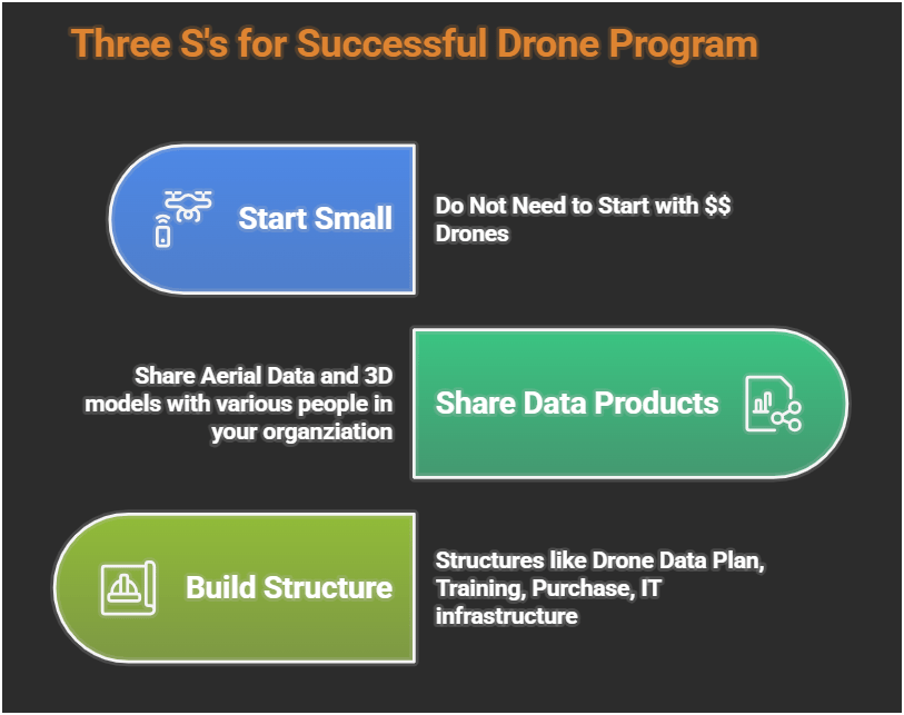
Building Drone Program
E3 S3
-
Small
-
Share
-
Structure
Easy
Efficient
Effective
HOW?
WHY?
Why Use Drones?
1. Easy - Simple with little effort

Automatic
Repeatable
E3
Flight Control App
Automate Flight Planning - Fly Consistently for overlapping images
Can fly manually but it's like mowing with scissors


Why Use Drones?
2. Efficient - Results without waste
Safety of staffs & Save Time & $$

E3
2. Efficient - Results without waste
Safety of staffs & Save Time & $$
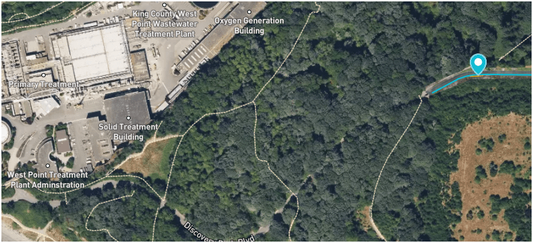
West Point
Treatment
Plant
Discovery Park
Blvd
Dec 2024
E3
Why Use Drones?
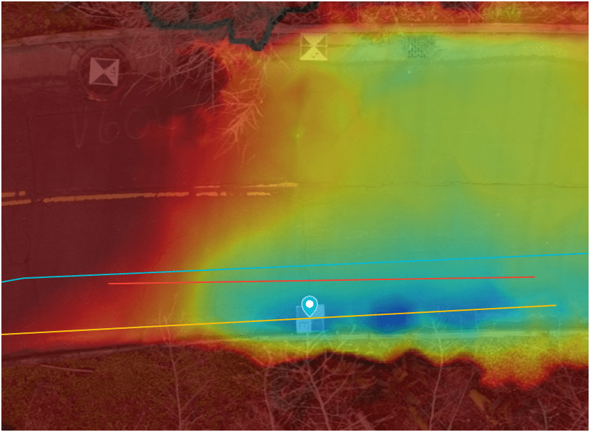
3. Effective - Producing Results


E3
0.50 in/px
June 2025
6x time the resolution
(from KC Aerial Imagery - June 2025)
Construction Site Monitoring
3. Effective - Producing Results
E3
Construction Site Monitoring
3. Effective - Producing Results
E3
Ship Canal Water Quality - TBM
3. Effective - Producing Results
E3
Building Drone Program
E3S3
-
Small
-
Share
-
Structure
WHY
-
Easy
-
Efficient
-
Effective
HOW
WHY?
- Ensure Continous Operation
- Support Capital Delivery & Maintenance
DJI Mavic 2 Pro (1)

Mavic 2 Ent. Adv. (1)

Mavic 3 Ent (2)

2021
2022
2023
Matrice 4 Ent. (1)
2025
Total: < $22,000
-
Small
-
Share
-
Structure
S3: Small
$1,800 (Retired)
$6,500
$3,800
$5,300/
$8,500
Latest Hardware
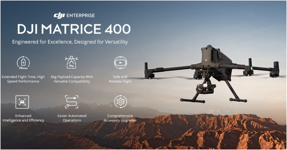
$11,000
All WEather
RGB Camera
~ $10,500
Lidar Sensor
~ $ 17,500
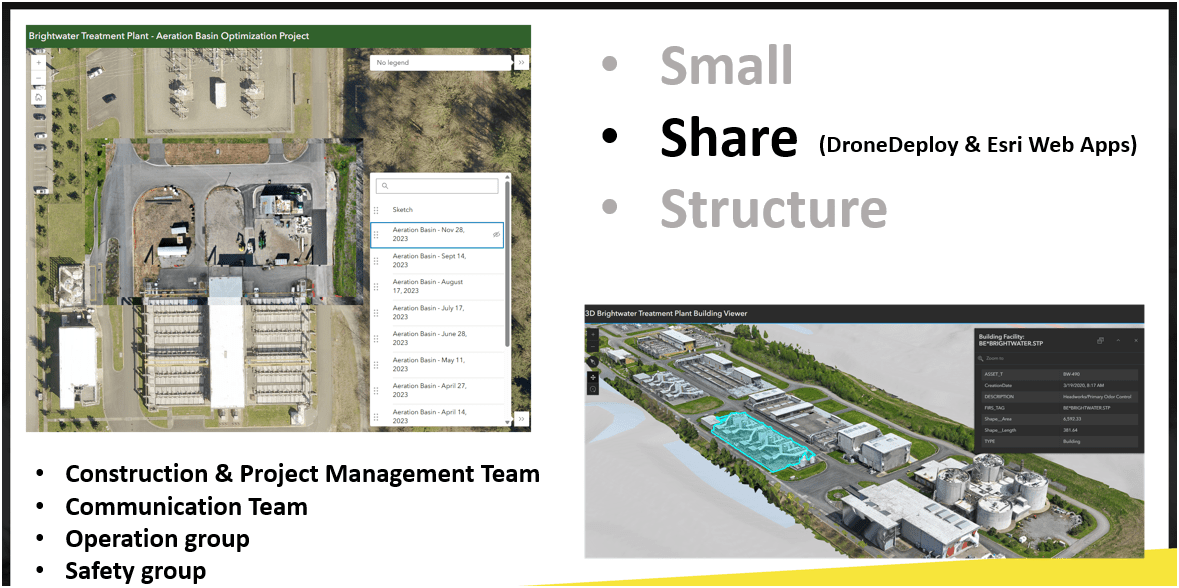
S3: Share
WTD Examples: 2D Aerial
Brightwater Treatment Plant - Construction Aeriation Building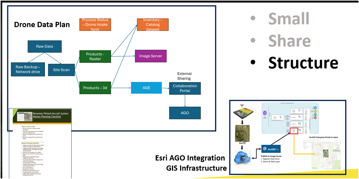
S3: Structure
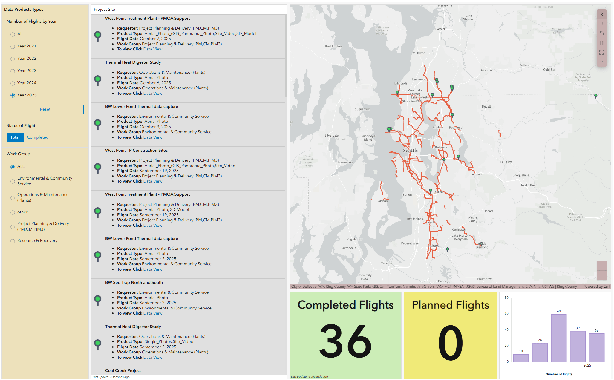
WTD Drone Dashboard
KC Wastewater Treatment Drone Program

People
+
Technology
+
Organization
=
Drone Program

Part I & II
-
Goal of the workshop
-
Participants
-
Hardware/Software
1
Introduction
1.1
-
Best Practice
-
Mission Planning
-
Flight Type - 2D/3D
-
Work flow
3
Flight Operation
-
Program Development
-
Examples (KC WTD)
-
Example (Lummi Tribe)
2
Drone Program
WTD GIS Team
-
10 GIS Specialists
-
4 FAA Certified Pilots
-
3 Studying to be Certified
-
Two Interns
-
Olivia
-
Max
-
Supervisor

WTD GIS Drone Program
May 2026
- Four FAA Part 107 Drone Certified Pilots - WTD GIS Specialists (3 Additional Staff training)


Joe
DJI Mavic 2 Pro (1)
Mavic 2 Ent. Adv. (1)
Mavic 3 Ent (2)
2021
2022
2023
Matrice 4 Ent. (1)
2025
Total: ~ $27,000
Current Hardware
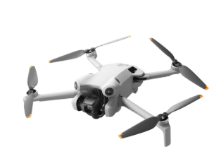
DJI Mavic 2 Pro < $1,800 (Retired)

DJI Mavic 2 Pro Ent. Adv $6,500
DJI Avata $1,300
Mavic 3 Ent (2x)
$3,800
20 MP/ 56x zoom
20 MP
12 MP/ 32x zoom
+ Thermal

Matrice 4 Ent
~ $5,300
Latest Hardware
$11,000
All WEather
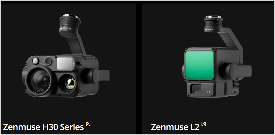
L3 - lidar
~ $ 18,000
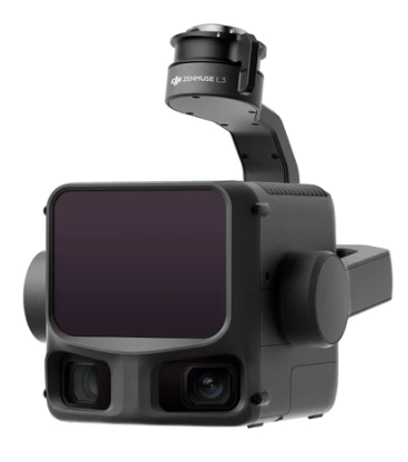
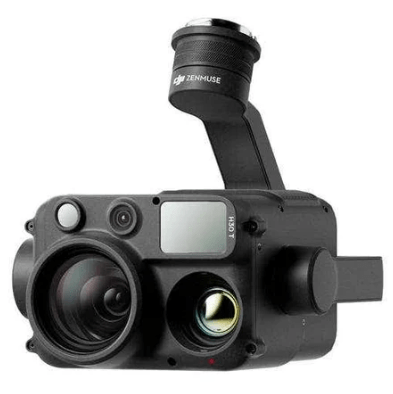
H30T - Thermal
~ $ 12,000
Part I & II
-
Goal of the workshop
-
Participants
-
Hardware/Software
1
Introduction
1.1
-
Best Practice
-
Mission Planning
-
Flight Type - 2D/3D
-
Work flow
3
Flight Operation
-
Program Development
-
Examples (KC WTD)
-
Example (Lummi Tribe)
2
Drone Program


Part III
5
1.1
-
GCP
-
Photogrammetry
-
Gaussian Splat
-
Lidar
-
Thermal
4
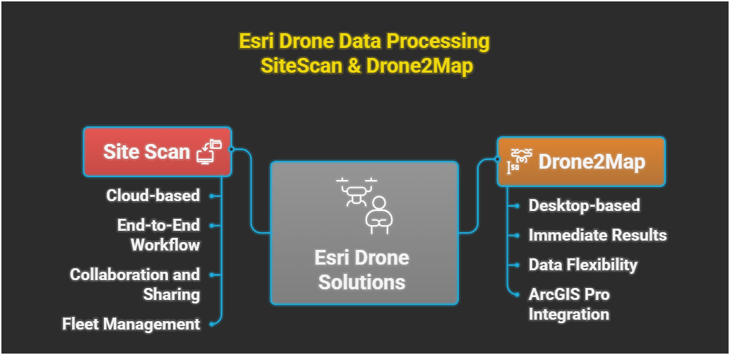
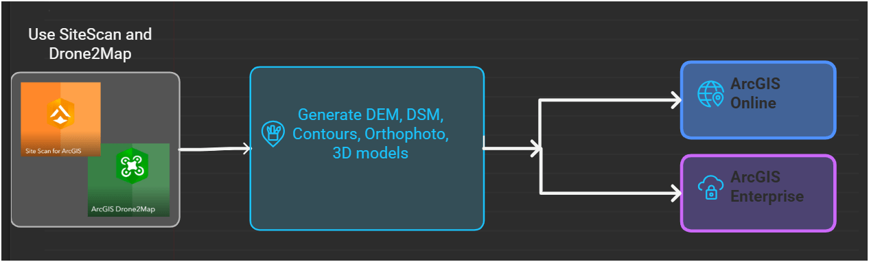
Data Processing Software
-
DroneDeploy
-
SiteScan/D2Map
-
Metashape
-
WebODM/Lightning
-
MapsMadeEasy
Flight Data Processing
- Imagery Magmt
- Esri Tools
- Data Integration Tools
- Examples (Webmaps, Apps)
6/7
Data Integration
8
Q & A plus
Discussion
Flight Operation (Continue)

Structure from Motion (SfM)
Part II: Data Processing

Photogrammetry
Part II: Data Processing

Data Processing

Input Sequences in DD
Ground Control Points


Increase accuracy of drone map

GCP's make your map accurate BUT do not let you know HOW accurate the map is.
Ground Control Points
RTK = Real-Time Kinematic

RTK with Mobile Base Station
RTK with NTRIP


NTRIP - Networked Transport of RTCM (internet protocol).
Require Constant Internet connection (cell) or subscrption
Ground Control Points
GNSS Receivers with RTK +
Esri FieldMap


Importance of Check Points
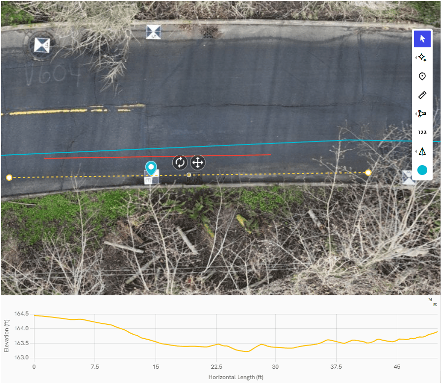
- Check points are physical markers in drone images where the precise GPS location is known
- Check Points give XYZ error in inches/cm with map products
- Single or average error does not guarantee the accuracy for all parts map
-
GCP = map processing
-
Check Points = calculating average errors

Part III
5
1.1
-
GCP
-
Photogrammetry
-
Gaussian Splat
-
Lidar
-
Thermal
4
Data Processing Software
-
DroneDeploy
-
SiteScan/D2Map
-
Metashape
-
WebODM/Lightning
-
MapsMadeEasy
Flight Data Processing
- Imagery Magmt
- Esri Tools
- Data Integration Tools
- Examples (Webmaps, Apps)
6/7
Data Integration
8
Q & A plus
Discussion
Flight Operation (Continue)
Data Products
EPSG Code - European Petroleum Survey Group
EPSG 4326: WGS 84, Longitude & Latitude Coordinate system
EPSG 3857: Web Mercator Projection (Esri = 1984 Web Mercator Auxiliary Sphere)
EPSG 2926: NAD83 Washington North NAD83


Drone Photo Data
- Esri Dashboard with Survey123
GIS Integration
- AGO Web App


- AGO 3D Scene Viewer App
GIS Integration

DD 3D Model


- Email Sign-up
- Resources
- Every 3rd Thursday
- ZOOM Meeting
- 148 Members