Geology of Helgoland

Vikram Unnithan
XX April 2026
Why Unique?
All surrounding islands are low sandy tidal barrier islands
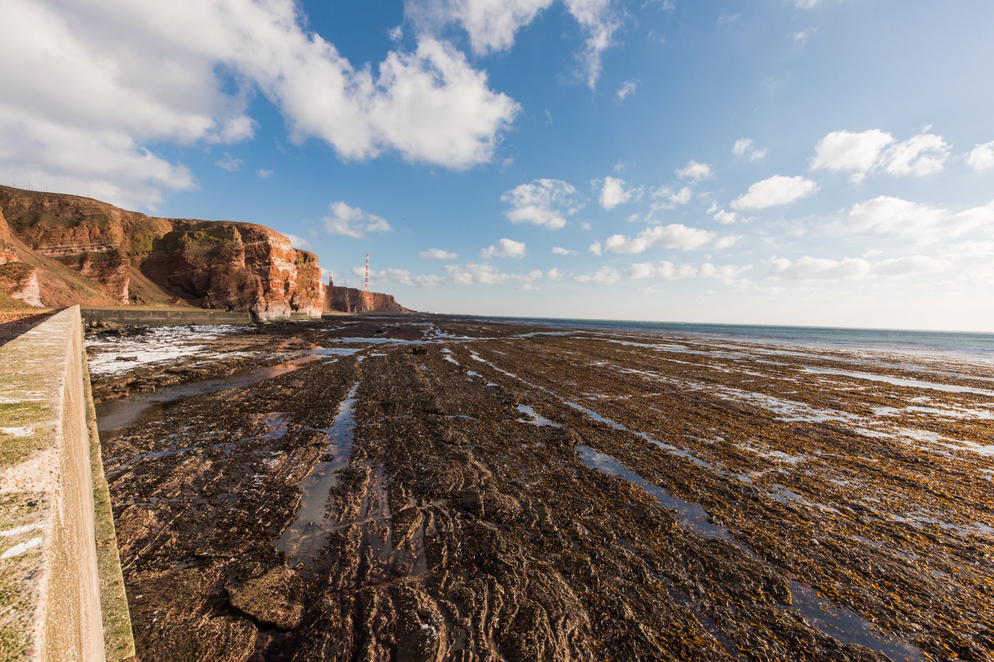
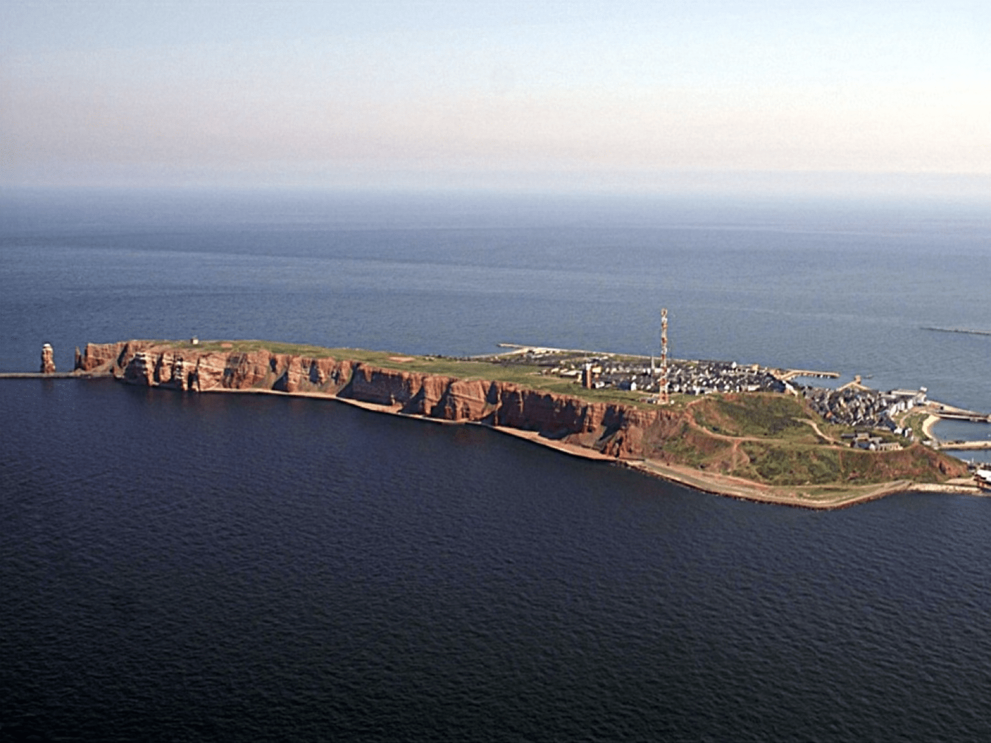
Helgoland is the only rocky island — uplifted Triassic sandstone, a product of salt tectonics
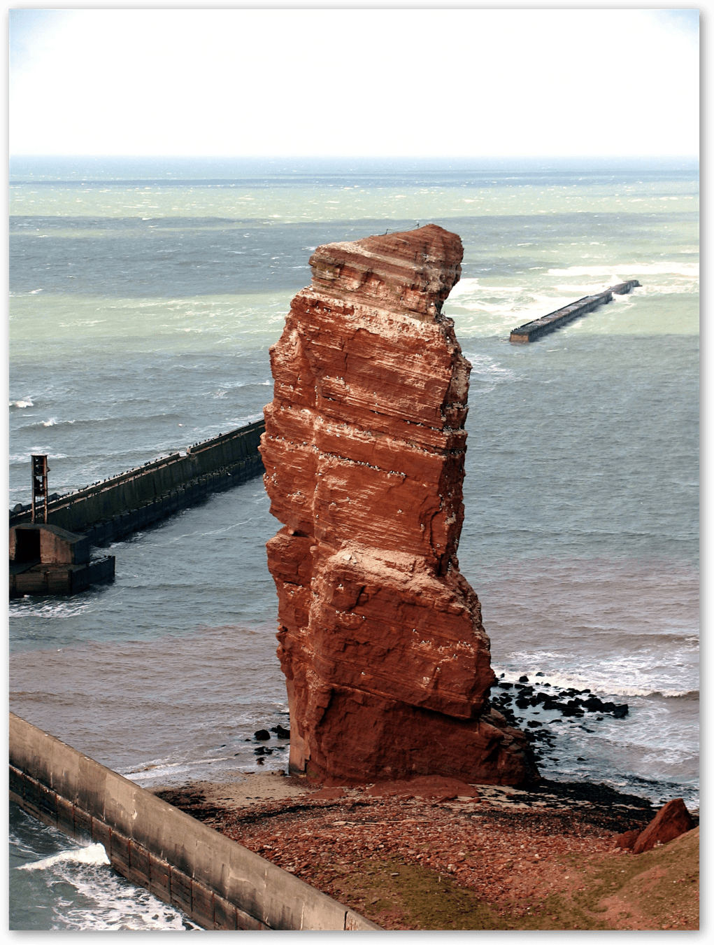
Lange Anna — the iconic 47 m red sandstone sea stack at the NW corner — is a remnant of a collapsed sea arch, now standing free. Classic erosional sequence: wave-cut platform → cave → arch → stack.
source
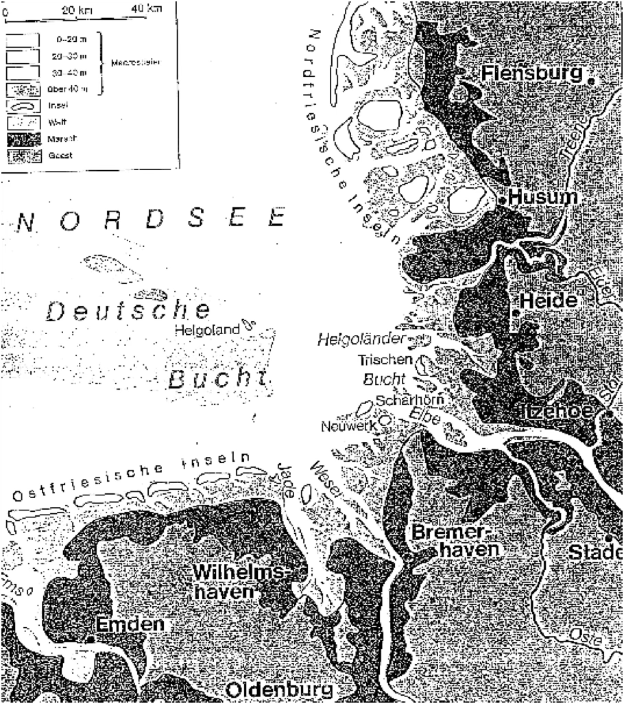
Overview map of the island of Helgoland. All the other islands are tidal barrier islands or related to the larger rivers of the Weser / Elbe, while Helgoland is the only rocky island. Helgoland is approximately 70km away from Cuxhaven or the island of Neuwerk.
Source: Wurm, D. 1991. Aktuogeologie und –palaeontologie rezenter Kuesten- und Flachwassersysteme am Beispielder suedlichen Nordsee. Excursion Aug. 1991. Institut fuer Palaeontologie der Universitaet Erlangen-Nuernberg. p.4
Location
Morphology
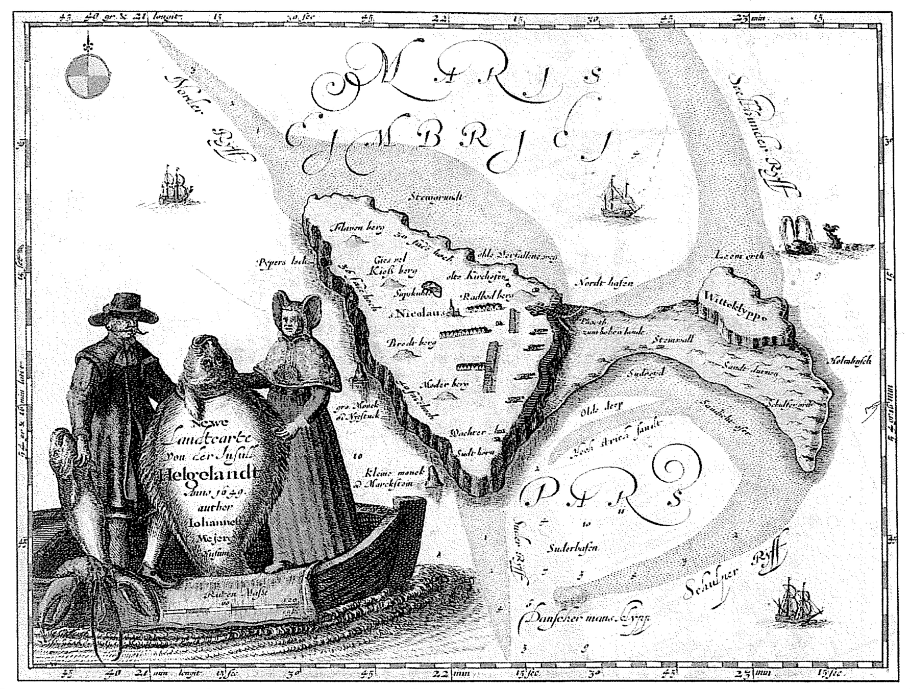
Map of 1650 clearing showing the rather different shape of the main island and Dune along with the sand spits. The later provide a good indication of the possible current patterns during that period.
Source: Ritsema, A., 2007. Heligoland, Past and Present. pg. 57. Lulu, UK)
Morphology
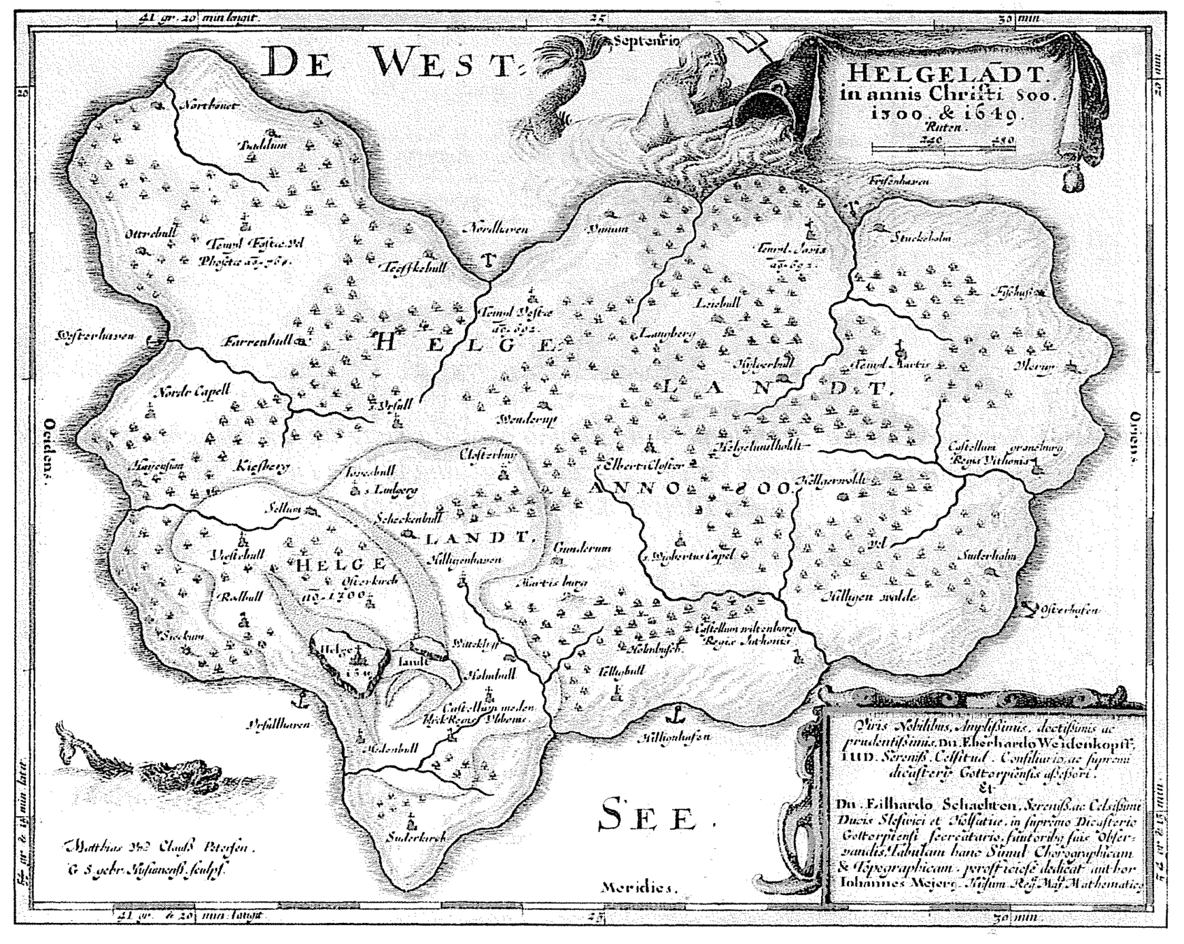
Another historic map from the 1500’s showing both islands and indicating the shallow inter-tidal region to the east and deeper ship anchor sites to the west of Helgoland. This points to relatively lower sea levels during this period.
Source/cited in: Anon., 1998. Helgoland Workshop, June 1998. Graduierten Kolleg “Dynamic Globaler Kreislaeufe im System Erde”. Leitung: T. Haneburth and L. Loewemark. pg. 9
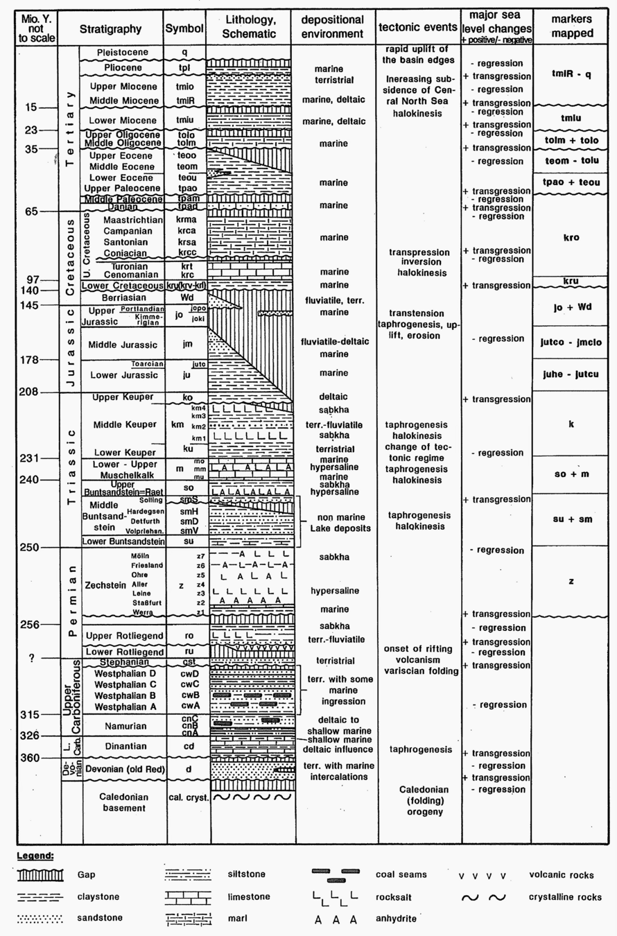
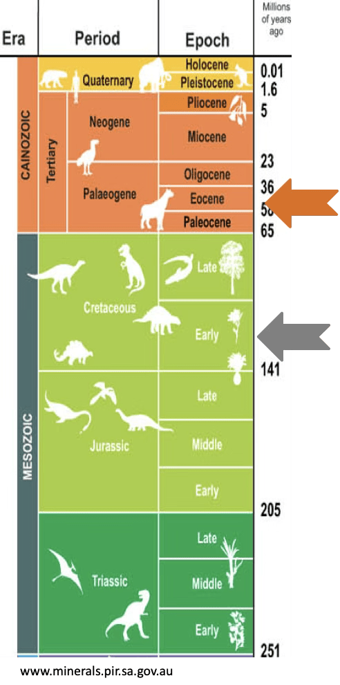
Lithostratigraphic column for the German North Sea. This diagram indicates lithology (sediment type), major tectonic events, changes in sea level and depositional environment through time. Read these diagrams from bottom (oldest) to top (youngest).
Source: Binot et al (eds), 2003. Exkursionsfuehrer zur Hochseeinsel Helgoland Zum Thema : Geologie des tieferen Untergrundes der deustschen Nordsee. Anlaesslish der 12. GGW-Jahrestagung in Husum vom 10-13 September 2003. Zusammengestellt von Franz Binot, Hans-Juergen Brauner und Heins-Gerd Roehling. pg. 31 (but aus: Baldschuhn et al, 1994)
NOTES / Questions:
What do the crenulated (wavy) horizontal lines in the logs indicate ?
What are the main depositional environments in the late Permian, Triassic and Cretaceous ?
What do transgressions and regressions mean ?
What are gamma ray logs useful and why is this important .. ?
Stratigraphy
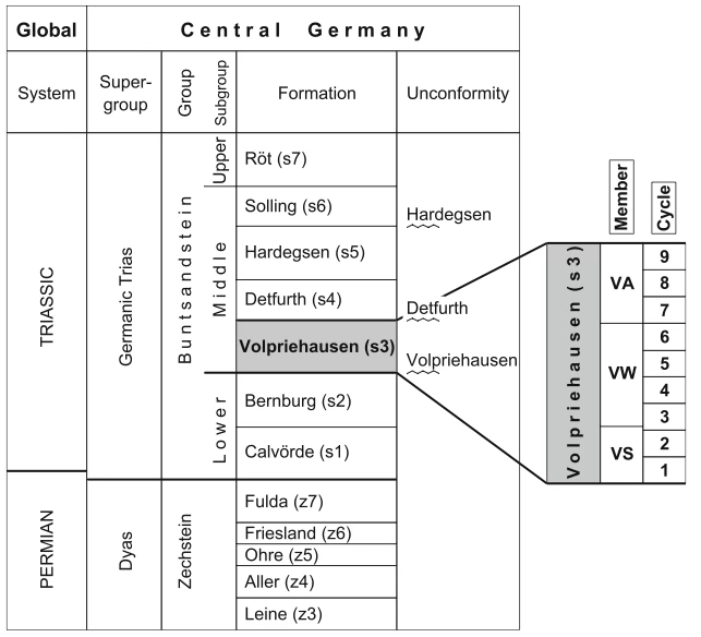
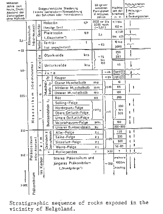
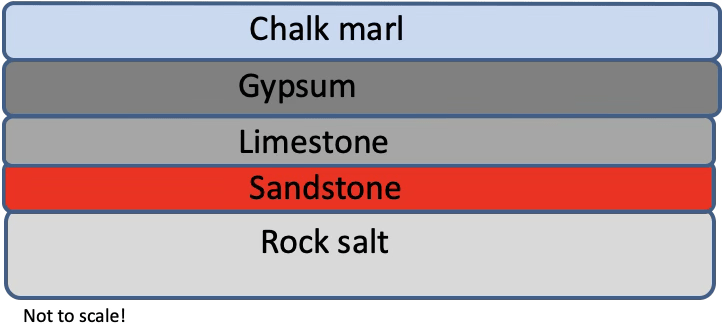
The stratigraphic sequence of rocks exposed on or around Helgoland (right – poor diagram). The most visible and characteristic subgroup of Helgoland is the Middle Buntsandstein. Of the various formations mentioned in the diagram (left), Volpriehausen is the most important.
Source: Schmidt-Thome, P., 1987. Helgoland – Seine Duenen-Insel, die umgebenden Klippen und Meeresgruende. Sammlung Geologscher Fuehrer No. 82. Gebrueder Borntraeger, Berlin.Stuttgart. pg. 22.
NOTES / Questions:
What is an unconformity ?
What is the definition of a formation, member and cycle ?
What might cause cyclicity in rocks ?
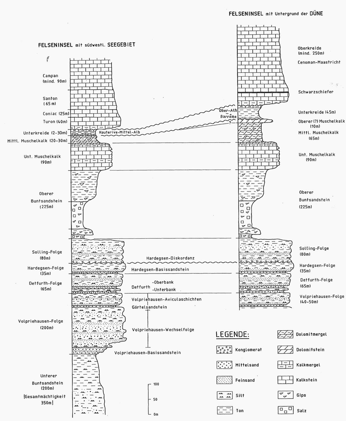
Stratigraphy
Detailed stratigraphic logs and correlations of the Helgoland and Dune. The x-axis is grain size and y-axis is relative time.
Note the thickness and lithology of each of the formations (“floge”). The translation of “Diskordanz” is unconformity or disonformity representing a break or “hiatus” in the depositional history.
Stratigraphy
~ 220 – 210 my years ago: formation of shell lime lime stone
~ 220 – 230 my years ago: sinking of land, deposition of sand and dust
~ 230 my years ago (Zechstein-period): evaporation of Zechstein Ocean, forming “rocksalt”
No depositions from Jurassic:
1. deposits were removed
2. movements of rock salts:
high elevation, no deposition, sinking and rising again.
~ 50 my years ago: Helgoland rose to the surface (salt-tectonic movement)
~ 135 my years ago: deposition of gypsum and chalk marl
Drifting of the „Zechstein-Salt“
Movement of the rock-complex
Buntsandstein · Triassic
Sedimentary Environments
Deposited in a continental playa-lake system at ~20–25°N within Pangea — an arid, semi-arid environment analogous to the modern Sahara. Material transported northward from the Variscan highlands.
🌊 Braided Rivers
Ephemeral streams from Variscan uplands; coarse-grained cross-bedded sandstone and conglomerate; Volpriehausen Basissandstein
☀️ Sheet Floods
Thin, planar-laminated sandstone sheets; rapid flash-flood events producing the white Katersand layers
💧 Playa Lakes
Fine siltstone/claystone with desiccation cracks, wave ripples and evaporite crystals; seasonal flooding and drying
🌬 Aeolian Dunes
Well-sorted fine sandstone with large-scale cross-bedding; frosted grain surfaces; consistent with NE and SE trade winds
🧂 Sabkha / Evaporite
Gypsum and anhydrite layers at sediment surface; supratidal evaporite flats at lake margins during dry phases
⏱ Cyclicity
Alternating coarse/fine driven by Milankovitch forcing (~20–100 ka); 7 first-order sequences in the Buntsandstein
Katersand — distinctive white sandstone layers within red Buntsandstein. Bleached post-deposition by reducing groundwaters dissolving hematite grain coatings.


Desiccation Cracks & Current Ripples
Current Ripples & Cross Bedding (aeolian)

Palaeontology
Fossils of Helgoland
Trace Fossils (Ichnofossils)
Body fossils are rare in oxidising playa deposits. The fossil record is dominated by traces — evidence of organisms rather than the organisms themselves.
Chirotherium ("Hand-Beast")
Five-toed pentadactyl footprints of pseudosuchian archosaurs — relatives of crocodile ancestors. Large carnivores (~2–3 m) crossing mudflat surfaces. First described from German Buntsandstein in 1834.
Other Trace Fossils
Rhynchosauroides — smaller reptile tracks
Planolites, Skolithos — worm burrows in wet sediment
Fuersichnus, Diplichnites — arthropod traces
Body Fossils
Buntsandstein — Very Rare
Plant debris in channel fills; fish scales in lacustrine sediment; freshwater ostracods in fine laminated silt
Muschelkalk (Subsurface)
Ceratite ammonites · Bivalves (Myophoria) · Gastropods · Brachiopods · Crinoid ossicles · Corals
Cretaceous Chalk (Düne)
Echinoids (Micraster, Echinocorys) · Inoceramid bivalves · Belemnites · Foraminifera · Coccolithophores
Desiccation crack networks and Manchuriophycus are sedimentary pseudofossils — not biological — but easily mistaken for trace fossils.
Mineralisation
Copper, Malachite & Hydrothermal Fluids
Historical Significance
Copper ore (including malachite) found in the NE tidal flat (Felswatt). Bronze Age peoples likely exploited copper from Helgoland — important for the early metallurgy of the North Sea region. Last documented occurrence: NE Felswatt, 1983 (Prof. L. Kies, Hamburg).
Copper Minerals
Malachite Cu₂(CO₃)(OH)₂ — bright green coatings, botryoidal masses
Azurite Cu₃(CO₃)₂(OH)₂ — deep blue, with malachite
Chrysocolla — blue-green silicate; botryoidal
Primary sulphides — chalcopyrite, bornite, chalcocite (precursors to green/blue minerals)
Two Origin Models
Model 1 — Red Bed Copper (Syngenetic)
Copper precipitated at redox boundary between oxidising red sediment and reducing organic-rich patches (plant debris in abandoned channels). Widely documented in Triassic red beds globally — analogous to the German Kupferschiefer.
Model 2 — Hydrothermal / Brine Migration
Salt dome rise creates fault conduits for hot metalliferous basinal brines (60–150°C). Brines leach Cu from red beds and basement; precipitate at redox barriers near the diapir margin. Evidence: gypsum veins cutting bedding; copper spatially associated with faults. The two models are not mutually exclusive — syngenetic copper may have been remobilised by later hydrothermal brines migrating along salt dome faults.
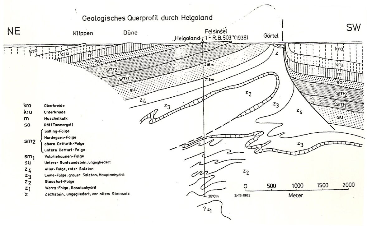
Structural map of Helgoland showing the surface distribution of the various lithologies and main structural elements (faults).
Source: Foerster et al., 2000. Felsinsel Helgoland. Ein geologischer Fuehrer. Enke, im Georg Thieme Verlag. Stuttgart. p. 67
Structure
Geology Picture Book
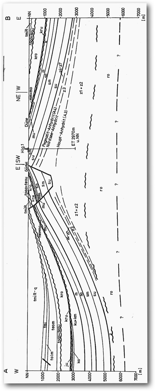
Vertical W-E cross-section through Helgoland highlighting the impact of halokinesis (salt movement) in the geological evolution of Helgoland. See previous figure for the legend.
Source: Binot et al (eds), 2003. Exkursionsfuehrer zur Hochseeinsel Helgoland Zum Thema : Geologie des tieferen Untergrundes der deustschen Nordsee. Anlaesslish der 12. GGW-Jahrestagung in Husum vom 10-13 September 2003. Zusammengestellt von Franz Binot, Hans-Juergen Brauner und Heins-Gerd Roehling. Pg. 56 (but aus: Binot, 1991)
Structure
Structure
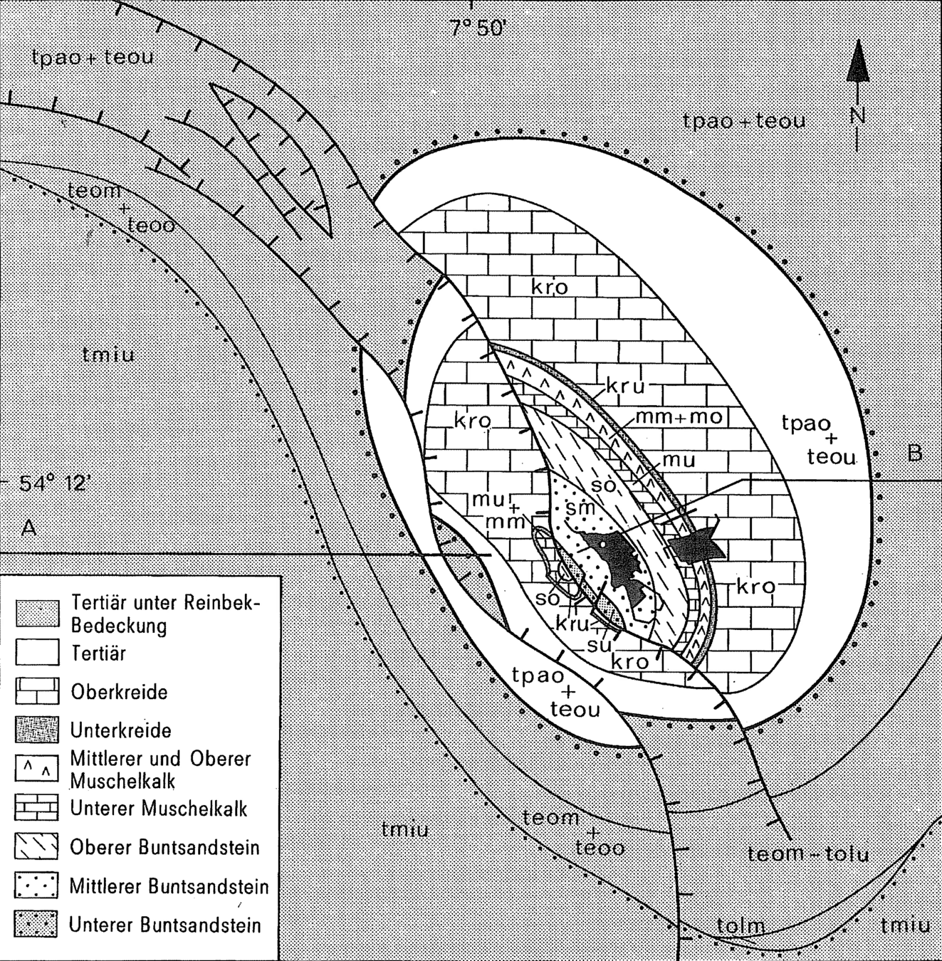
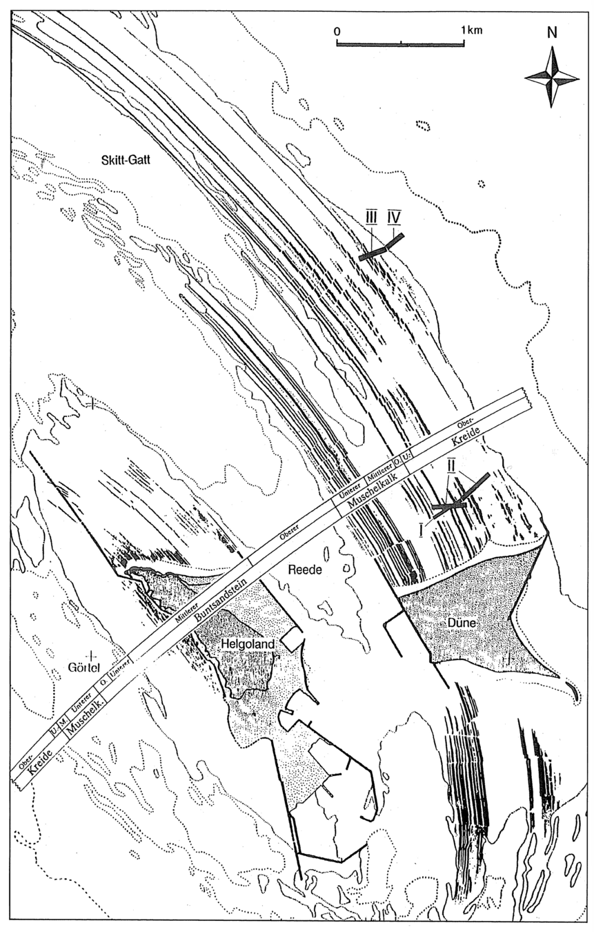
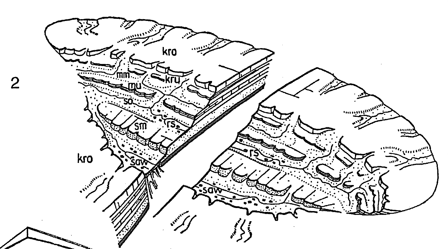
Detailed map of the geology of Helgoland and Dune. Note the location and outcrop of the rocky inter-tidal region north and south of the islands.
Source/cited in: Anon., 1998. Helgoland Workshop, June 1998. Graduierten Kolleg “Dynamic Globaler Kreislaeufe im System Erde”. Leitung: T. Haneburth and L. Loewemark. pg. 2
Structure
Geology Picture Book
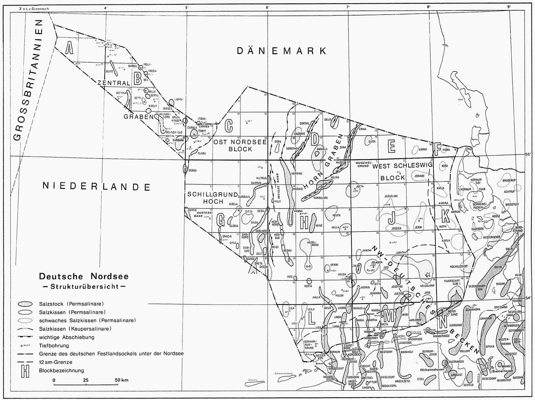
Subsurface structural map of the German North Sea. Geologically, Helgoland forms part of the NW German Basin. This map also shows the location of salt structures in the subsurface.
Source: Binot et al (eds), 2003. Exkursionsfuehrer zur Hochseeinsel Helgoland Zum Thema : Geologie des tieferen Untergrundes der deustschen Nordsee. Anlaesslish der 12. GGW-Jahrestagung in Husum vom 10-13 September 2003. Zusammengestellt von Franz Binot, Hans-Juergen Brauner und Heins-Gerd Roehling. Pg. 30 (but aus: Niedersaechsisches Landesamt fuer Bodenforschung, 1997).
Salt Diapirs
Geology Picture Book
Halokinesis or salt movement mechanisms due to increase in pressure and temperature. This diagram shows the most common forms or morphologies in the North Sea ranging from salt domes (circular) to pillars to cushions.
Source/cited in: Anon., 1998. Helgoland Workshop, June 1998. Graduierten Kolleg “Dynamic Globaler Kreislaeufe im System Erde”. Leitung: T. Haneburth and L. Loewemark. pg. 4
Structure
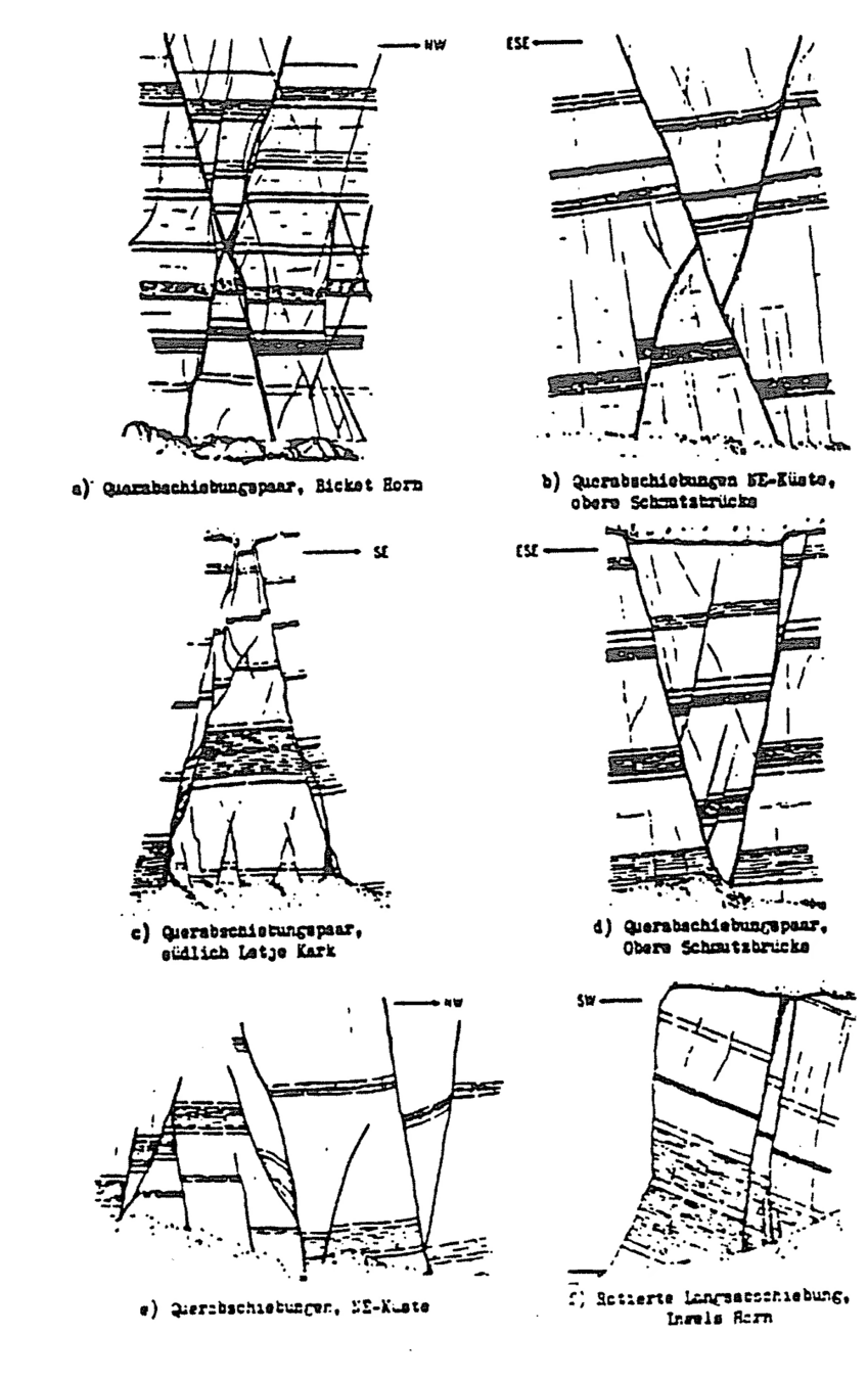
Sketches (vertical sections) of the various outcrop scale tectonics seen in the cliffs of Helgoland. Note most are high angle extensional or compressional faults / fractures.
NOTES / Questions:
What is the significance of high angle (near vertical) fractures and faults ?
Do compressional and extensional structures often go hand in hand ?
Structure
Geology Picture Book
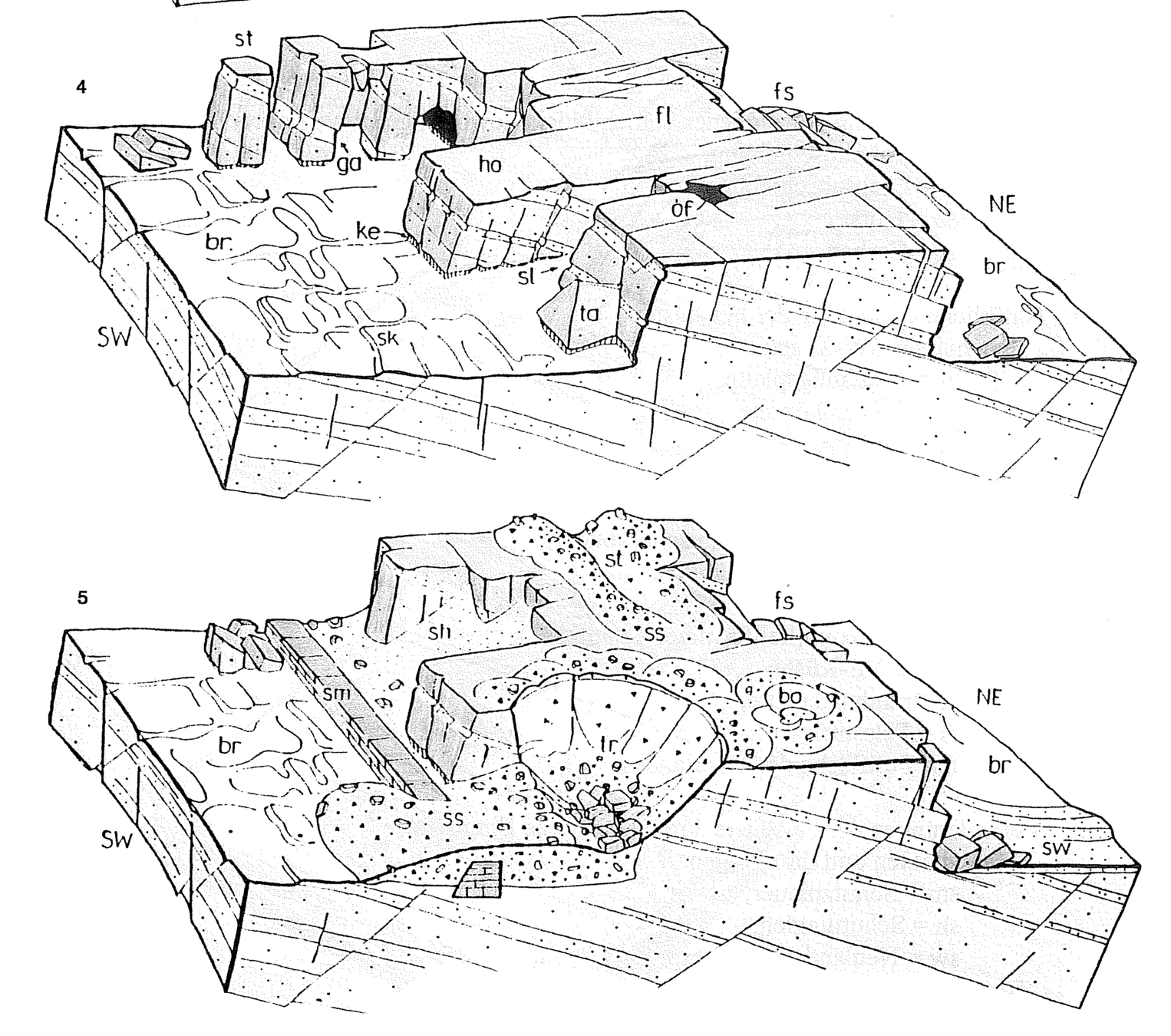
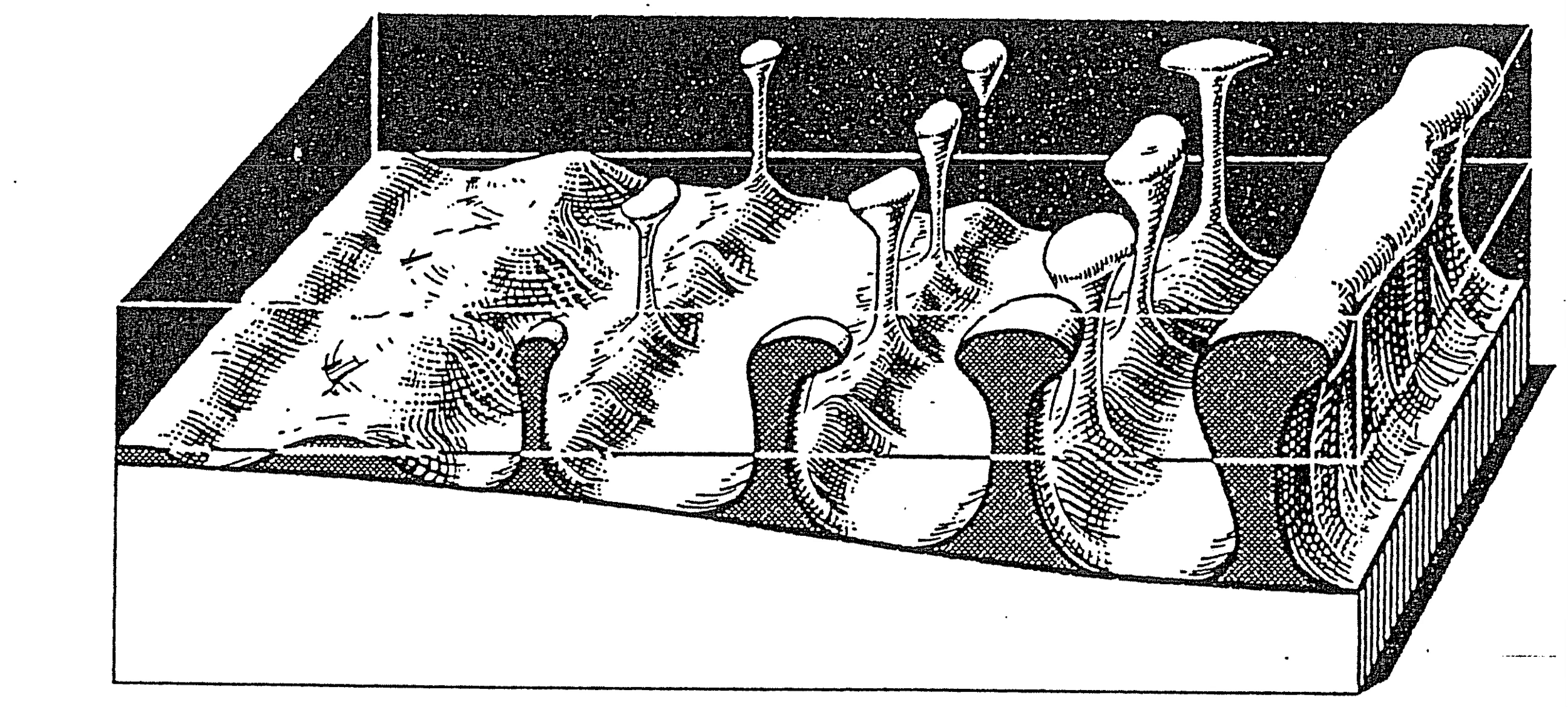
Block diagrams showing the impact of faulting and lithology on the nature and extent of erosion.
Source: Binot et al (eds), 2003. Exkursionsfuehrer zur Hochseeinsel Helgoland Zum Thema : Geologie des tieferen Untergrundes der deustschen Nordsee. Anlaesslish der 12. GGW-Jahrestagung in Husum vom 10-13 September 2003. Zusammengestellt von Franz Binot, Hans-Juergen Brauner und Heins-Gerd Roehling. Pg. 64. (but aus: WURSTER, 1962).
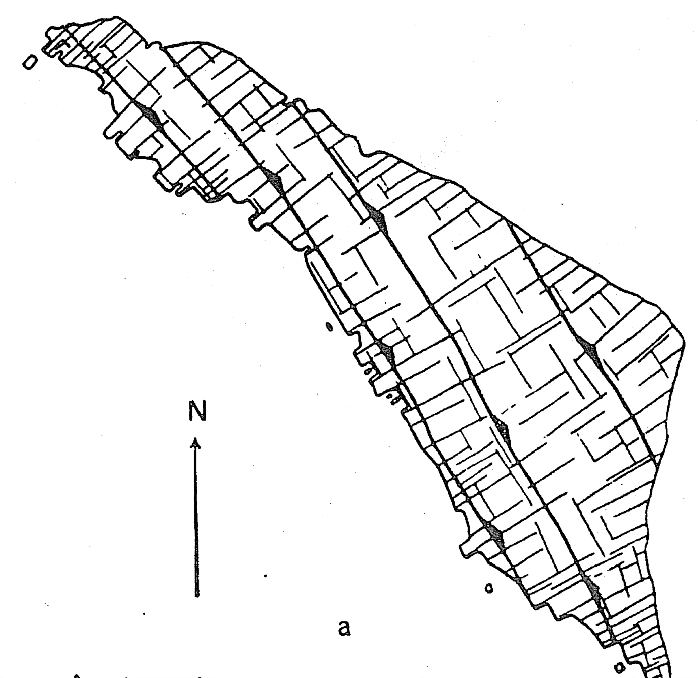
Map of the main structural trends (faults and fractures) on Helgoland. Note the distinct orthogonal pattern.
Structure
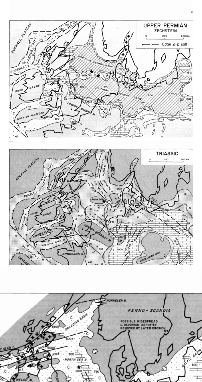
Paleogeographic maps from the Upper Permian and Triassic (Source: Ziegler 1979
NOTES / Questions:
Where is Helgoland on the two maps ?
What was the depositional environment during the Permian and Triassic in northern Germany ?
Towards which direction was material being transported during the Triassic ?
Paleogeographic Maps
~20 ka · Pleistocene
Last Glacial Maximum. Sea level ~120 m lower. Helgoland part of Doggerland — land bridge used by early humans, mammoths, reindeer.
Post-glacial sea level rise (120 m over 10,000 years) progressively flooded Doggerland. Helgoland isolated as an island by **8,000–9,000 years BP**.
~50 Ma · Eocene
Salt dome rises. Helgoland emerges at the sea surface. Differential erosion exposes the red sandstone core while chalk is removed.
~100–65 Ma · Cretaceous
Chalk Sea — warm, shallow, high sea level. White chalk deposited uniformly across northern Europe. Now preserved below the Düne.
~242 Ma · Muschelkalk
Warm Muschelkalk Sea floods the basin from the Tethys. Tropical shallow-marine carbonates. Helgoland near the western margin of the seaway.
~250–240 Ma · Triassic
Arid playa-lake environment. Red Buntsandstein deposited by rivers flowing north from Variscan mountains. Trade winds from NE and SE.
~255 Ma · Permian
Zechstein Sea floods the basin. Evaporation deposits >2,280 m of salt. Located ~20–25°N in interior of Pangea. Subtropical, arid climate.
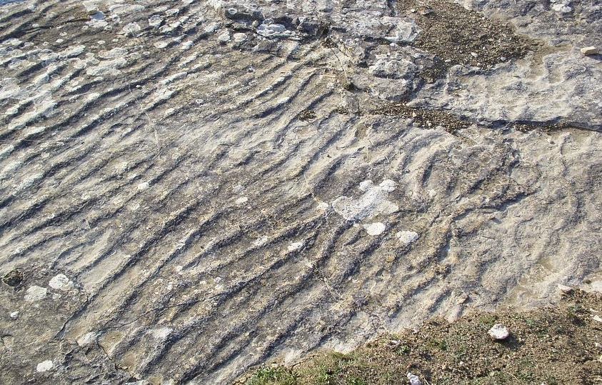
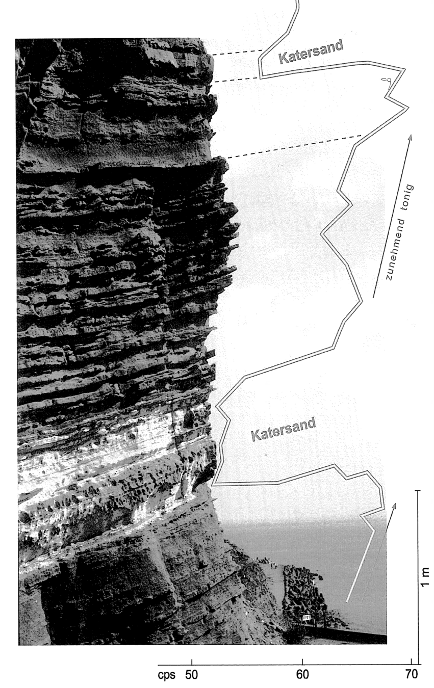
Another photograph from Helgoland showing the typical white “katersand” layers. Source: Binot et al (eds), 2003.
NOTES / Questions:
What does “katersand” mean ? What was this sandstone used for ?
Describe the sandstone in terms of lithology, colour and degree of lithification.
What are the current theories for the formation of the katersand ?
What depositional features can be seen in the katersand ?
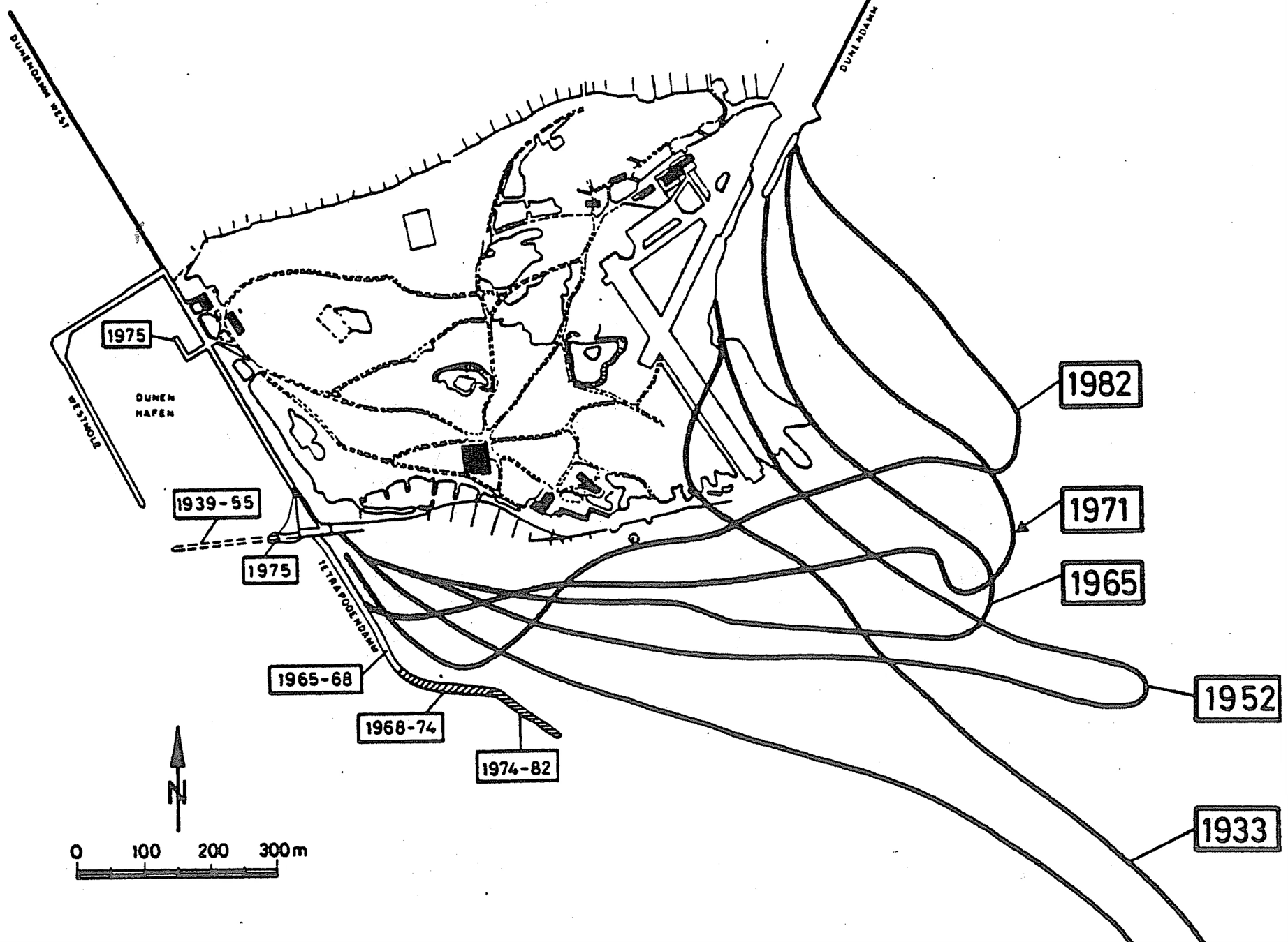
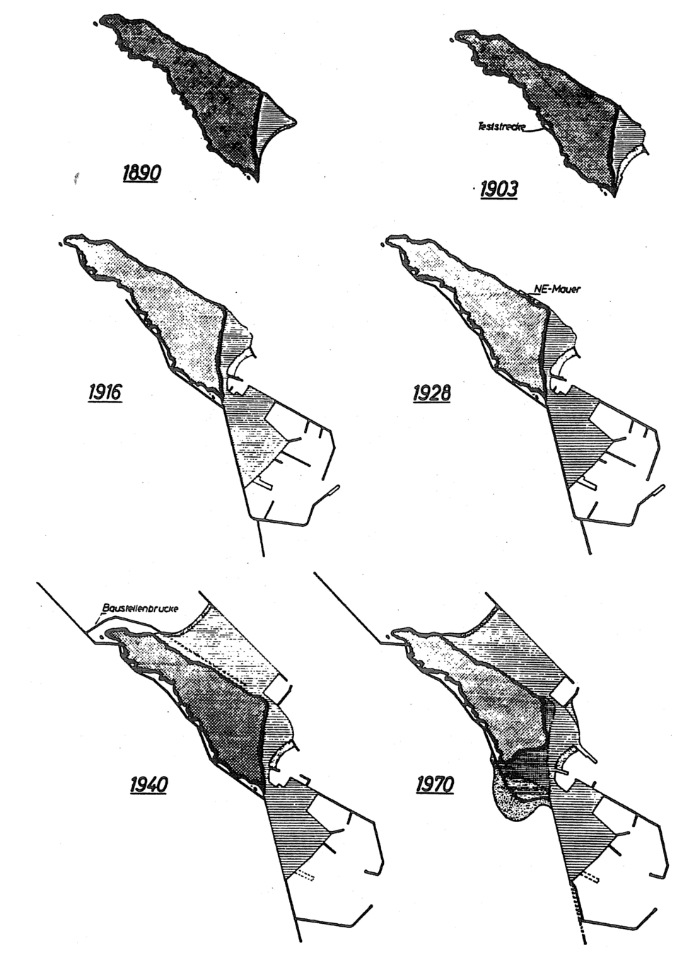
Historical development of Helgoland.
Source: Binot et al (eds), 2003. Exkursionsfuehrer zur Hochseeinsel Helgoland Zum Thema : Geologie des tieferen Untergrundes der deustschen Nordsee. Anlaesslish der 12. GGW-Jahrestagung in Husum vom 10-13 September 2003. Zusammengestellt von Franz Binot, Hans-Juergen Brauner und Heins-Gerd Roehling. Pg. 67 (but aus: KRUMBEIN, 1979).