SURVEYING-I
UNIT-1
PART-2
According to RTU syllabus
Classification of surveying based on purpose-
1.Topographical survey-
It is a survey to locate the natural and artifical features of the earth.
e.g.rivers,woods,hills etc.
2.Engineering survey-
These are surveys used for engineering works like railway,
highway,canal,bridge etc.
3.Cadastral survey-
It is done to establish property boundaries for legal purposes.
4.Hydrographic survey-
These surveys are conducted on or near the water body such as lakes,rivers etc.
5.Astronomical survey-
These surveys are conducted for determination of latitudes,longitudes,local mean time etc.at various places on the earth by observing heavenly bodies.
6.Geological survey-
These surveys are conducted to obtain information about different strata of the Earth's surface.
Classification of survey based on instruments used-
1.Chain surveying-
In this surveying only linear measurements are taken either with a chain or tape.
2.Compass surveying-
In this surveying horizontal angles are measured with a magnetic compass and linear measurements are taken either with a chain or tape.
3.Levelling-
In this survey a levelling instrument is used for determination of elevations of various points
4.Plane table survey-
In this survey plan is produced by determining direction of various points and taking linear measurements with chain or tape.
5.Theodolite survey-
In this survey horizontal and vertical angles are measured with theodolite.
6.Tacheometric survey-
In this surveying horizontal and vertical distances are measured with tacheometer.
7.Photogrammetric survey-
In this survey photographs are taken for an area which are inaccessible or time available is less and area to be survey is large.
8.EDMI(Electronic Distance Measuring Instrument) survey-
In this survey carrier waves are used for linear measurements.
Ex-Total station
Principles of surveying-
There are two basic principles of surveying-
1.Working from whole to part.
2.Locate a point by atleast two measurements.
Working from whole to part
Main objective of working from whole to part is to localise the errors whereas if we work from part to whole the error gets maximised.
20 m
20 m
20 m
20 m
20 m
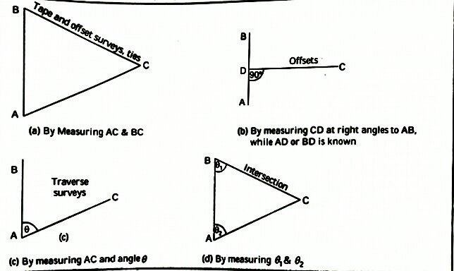
Locate a point by atleast two measurements
If A and B be the two control points whose positions are already known on the plan,then position of C can be plotted by any of the following methods-


Aditi Sharma