
slides.com/geoshape/geoshape
Who are we?
Syrus Mesdaghi
Co-Founder
syrusm@prominentedge.com
Daniel Berry
dberry@boundlessgeo.com
Software Engineer
What will we cover?
- What is GeoSHAPE
- GeoSHAPE Components
- MapLoom
- GeoNode
- GeoServer
- GeoGig
- Installing GeoSHAPE
- Software Components (RPMs)
- Demo
- Roadmap
- Q&A
Developed Under ROGUE-JCTD Project
- Part of a set of capabilities known as GeoSHAPE
- geoshape.org
- github.com/rogue-jctd
- https://groups.google.com/forum/#!forum/geoshape

- Goal: streamline collaboration on geospatial data between distributed partners
- Since 'partners' can include different government agencies, organizations, volunteer groups
- GeoSHAPE had to be free and open source
- Easy to deploy
- Each partner will have their own instance of GeoSHAPE
- Can edit and synchronize with other instances
- Initial funding of GeoGig
- Fully operational in disconnected mode
- Can edit and synchronize with other instances

GeoSHAPE Components
MapLoom
Web-based Viewer/Editor With GeoGIG integration
github.com/rogue-jctd/maploom

MapLoom
- Developed to address our challenges with GeoExplorer
- OpenLayers 3 + Angular + Bootstrap
- We embed it in GeoNode, but can be stand alone
- Bring in layers from local and remote servers
- Supports time dimension
- WGS84 Support (Raster Reprojection)
- MGRS Support
- GeoGIG Integration
GeoNode
Manage Layers, Maps, Users & Groups
github.com/GeoNode/geonode/

GeoNode
- Hides GeoServer's complexity when dealing with layers and users
- Allows you to customize your web application
- Upload / Download Layers
- Save / Load Maps
- Manage Users and profiles
- Manage Groups
- Manage Permissions
- Edit Styles

GeoServer
Serves GIS Vector & Raster data through OGC Standards
github.com/geoserver/geoserver

GeoServer
- Does a lot of the heavy lifting behind the scenes
- Manages data sources
- Supports numerous spatial formats
- Exposes OGC standards for accessing layers

GeoGig
- A data source that focuses on versioning vector data
- De-centralized Version Control System
- Heavily inspired by Git, but it is not Git
- Instead of versioning controlling text files, it versions layers / features
- You can commit, pull, push, branch, merge, revert, clone, shallow clone, sparse clone, and many operation which exist in git
- Should be used instead of PostGIS only when history matters
- GeoGig optimized for history
- PostGIS optimized for performance
- github.com/locationtech/geogig

Arbiter
Mobile application for viewing / collecting data
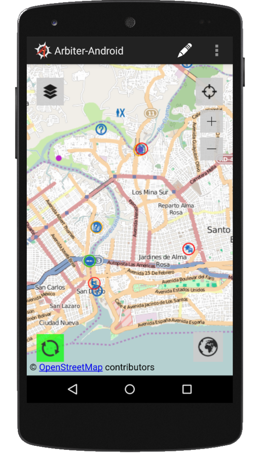
Arbiter
- Mobile application for viewing / collecting data
- Allows you to easily attach photos to features
- Designed to works in disconnected mode
- It downloads the vector data based on your area of interest
- Uses mbtiles for the basemap
- Native Android UI + Open Layers
Installing GeoSHAPE
- See doc on geoshape.org
- Install git, virtual box, and vagrant
- run vagrant up
Software Components (RPMs)


:8000
:80/443
:8009
:9200
:5672
:5432

GeoGig


GeoServer
GeoSHAPE
Demo!
Roadmap
- Geogig support high-availability
- PostgreSQL or SQLite backend storage for GeoGig
- Docker Integration
- osgeo-importer
- Arbiter update
- Powerful discovery of layers in maploom
- Ability to bring in data from more remote sources
- Security Updates
Final Thoughts
- We contribute all changes back to each project
- Use can use GeoSHAPE in whole or individual components
- Several companies/organizations have been contributing back
- Currently accepting pull requests ;)