GIS Web Application for
Faculty of Engineering
تطبيق نظم المعلومات الجغرافية على شبكة
الإنترنت لكلية الهندسة
By : HM² Team
< GIS / What ? >
What is GIS ?
A Geographical Information System (GIS) can be defined as a computerized system which
facilitates the entry of geo-referenced data, analyze that data in different ways and finally present
the analyzed data in different forms like maps.


GIS = Information System + Geographic Position
< GIS / Components >
GIS Components
Organized collection of :
- Hardware
- Network
- Software
- Data
- People
- Procedures
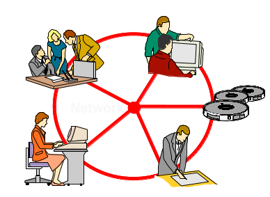
People
Software
Hardware
Data
Procedures
< GIS / Components / Hardware >
Hardware
The hardware is the computer and peripherals on which the GIS operates .
- Computers
- Networks
-
Peripheral devices ( Pointers, Plotters, Digitizers )
< GIS / Components / Software >
Software
Provides the functions and tools users need to store, analyze and display geographical information.
- GIS Software
- Database Software
- OS Software
- Network Software
< GIS / Components / Data >
Data
The most important part, different types :
-
Raw data ( original data material )
- Raster data ( top-down photograph of the earth "Basemap" )
-
Vector data ( Point, Line, Polygon )
- GIS data are called Spatial data which is " Information referenced by its location in space ", and stored in so called, Spatial database, like ( PostgreSQL database with PostGIS extention )
< GIS / Components / Data >
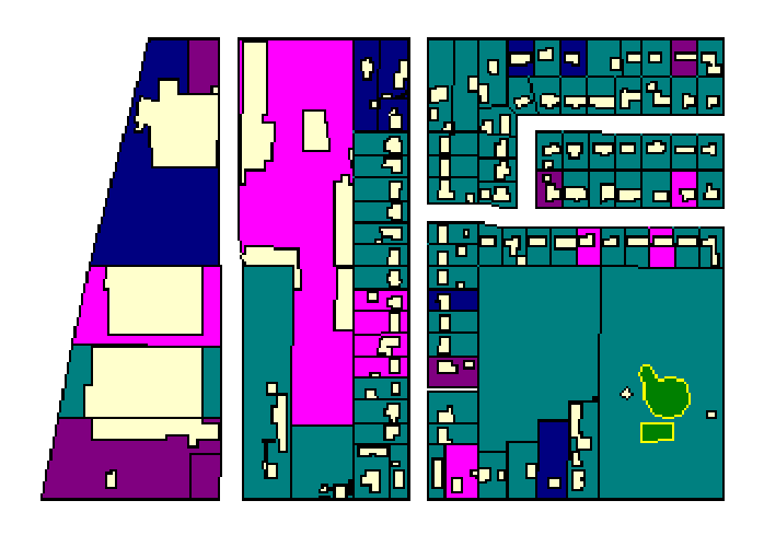
Vector Data
< GIS / Components / Data >
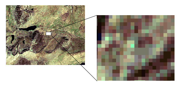
Raster Data
< GIS / Components / People >
People
- Administrators
- Managers
- GIS Technicians
- Application experts
- End Users
- Consumers
< GIS / Why ? >
GIS benefits Illustrated
in its Applications
-
Explore new places
- Driving Routing
- Decision Making
- Statistics
- etc .....
< GIS / End-User >
Final Product
GIS End-User product :
Desktop Application
Mobile Application
Web-Browser Application
Our final project is a Web-Browser Application
< GIS / Confusion ! >
Clarification !
- GIS & GPS
- Our GIS project & Google Maps
< GIS / Project >
Our Project
Our main goal is to build a GIS web-based application based on Data of college of Engineering, the only data we have are images of maps containing information about buildings, rooms and data about rooms
These are the Raw Materials
< GIS / Project / Steps >
What next ?
Now, we need to :
- Convert Raw data to Spatial Data
- Prepare data
- Store data
- Manage data
- Retrieve data
< GIS / Project / Convert Data >
Google Earth
We used Google Earth desktop application to convert raw material to spatial ones
< GIS / Project / Convert Data >
Google Earth
- Set location to building I'm working on
- Import Each floor's image as " Image Overlay "
- Adjust image to be fit on top of building
- Draw each Room one by one
- Repeat for all floors & for all buildings
- Export result as " .kml " files
< GIS / Project / Prepare Data >
Quantum GIS
A cross-platform free and open source desktop geographic information systems (GIS) application that provides data viewing, editing, and analysis capabilities
< GIS / Project / Prepare & Store Data >
Quantum GIS
-
Import .kml files made by Google Earth
- Check data
- Fix data ( Snipping data )
- Fill in features' attributes
- Export to .shp files or to PostGIS Database
< GIS / Project / Manage & Retrieve >
OpenGeo Suite
The OpenGeo Suite is a fully open geospatial software stack for publishing your data on the
web. The Suite includes the following software:
PostGIS - PostGIS is a robust spatial database system.
GeoServer - GeoServer is a map and geospatial data server.
GeoExplorer - GeoExplorer is browser-based tool commonly used to view, navigate, and
manage data from Suite components (locally and remote).
GeoWebCache - GeoWebCache is a tool that speeds up your Suite maps by pre-drawing and caching map images.
< OpenSuite / PostGIS >
PostGIS
- What is PostGIS ?
- What is a Spatial Database ?
< OpenSuite / GeoServer >
GeoServer
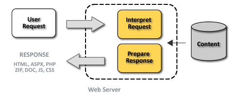
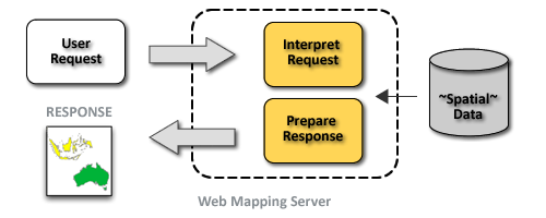
GeoServer is an open source software server written in Java that allows users to share and edit geospatial data.
GeoServer publishes data from any major spatial data source using open standards.
< OpenSuite / GeoServer >
Web Server vs. Web Map Server
< OpenSuite / GeoWebCache >
What is GeoWebCache ?
GeoWebCache is a tool that boosts the performance of a WMS by pre-drawing and saving map images for faster responses to client requests.
< OpenSuite / Web-Client >
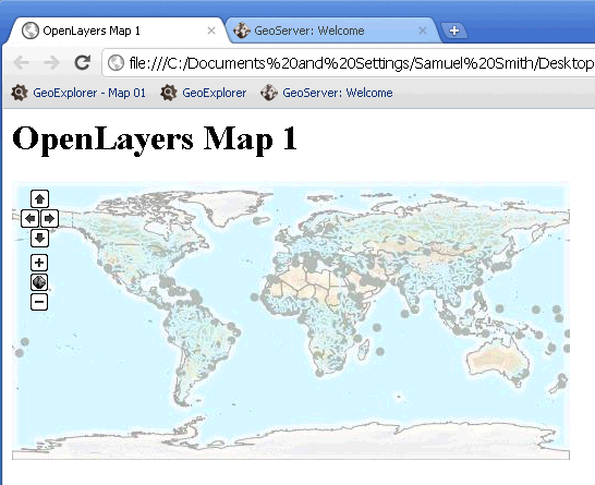
What is OpenLayers ?
OpenLayers is a JavaScript library for building mapping applications in a browser. Mapping applications consist of map layers (raster- or vector-based, integrated from a variety of sources), and controls for operating on those layers.
Map code
  var map = new OpenLayers.Map("map-id");
  var world = new OpenLayers.Layer.WMS(
    "Earth",
    "http://localhost:8080/geoserver/wms",
    {layers: "earthgroup"}
  );
  map.addLayer(world);
  map.zoomToMaxExtent();
Result
Steps
- Drawing ( Google Earth )
- Collecting, filling data, drawing and finishing
( Quantum GIS Desktop)
-
Store in database ( PostgreSQL )
- Visualizing Data ( GeoServer )
- Final product " web view "
( HTML, CSS, OpenLayers JavaScript library )
Troubles
- Expensive software solutions, solved by using
free OpenSource alternatives
- Long processing time, solved by using GeoWebCache
- Big data to be entered, we used only a sample of real data
to achieve minimum value product
How to develop in future ?
Thanks
Project website
