Title Text
Jessica Sena - @jsenag

#LasCallesDeGirona

Visibilizar la escasa representación de mujeres en espacios públicos y digitales
Para conseguirlo:



Acción 1:
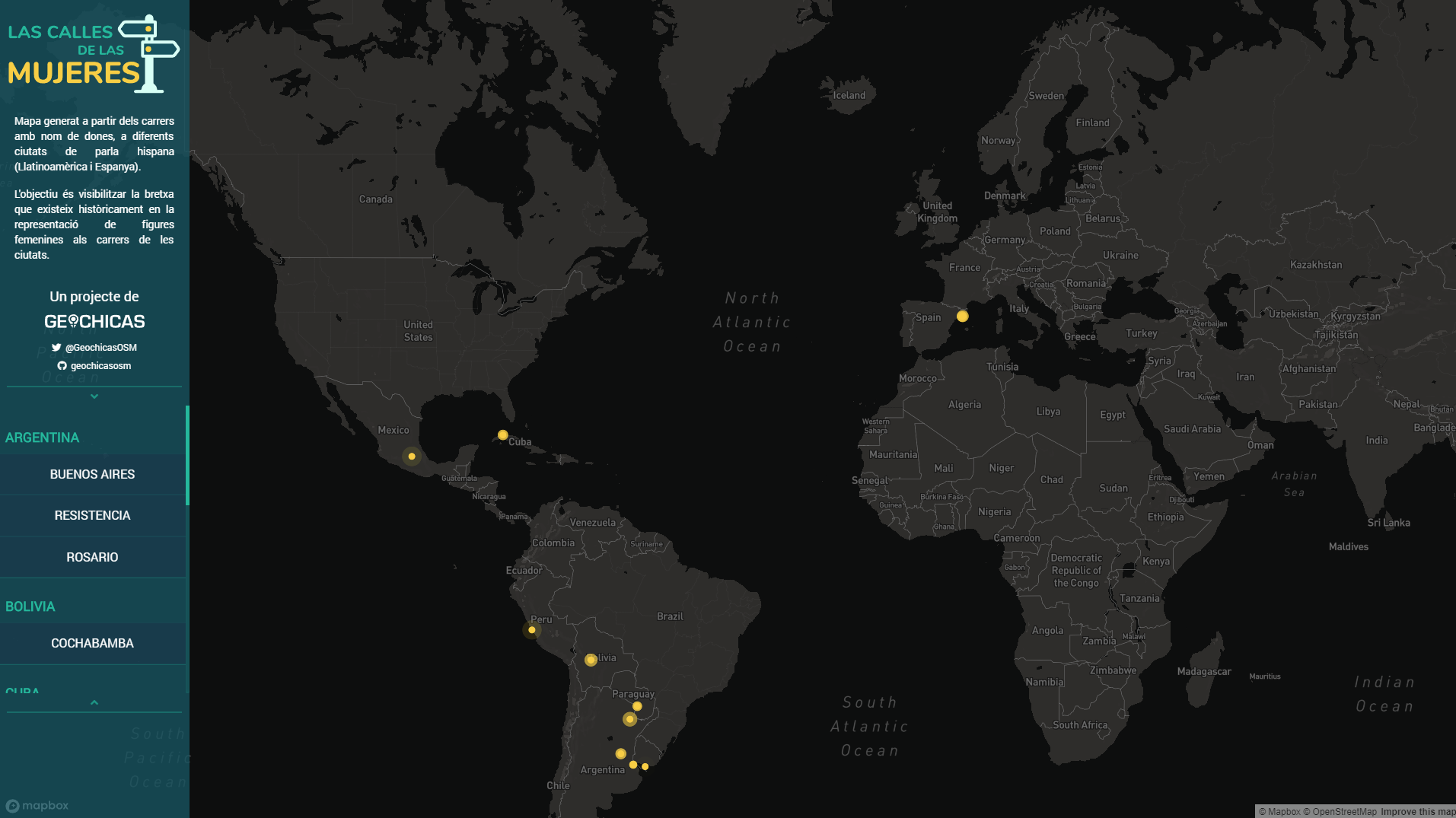
Crear un mapa mundial.
Representar las calles con nombres de mujer y de hombre.
Acción 2:
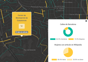
Enlazar cada calle de mujer con su artículo en Wikipedia
Identificar cuáles no tiene entrada

Proceso técnico
2. Tratamiento de datos
3. Generar el visor
1. Extracción de datos
1. Extracción de datos
OBJETIVO:
Obtener fichero con SÓLO las CALLES de una ciudad
Herramientas:
Tile Calculator - OSM QA Tiles - TileReduce

1. Extracción de datos
1. Extracción de datos

Implementa MapReduce
Análisis geoespacial distribuido
JavaScript + Mbtiles
1. Extracción de datos


Gestión de Tiles
Gestión resultados parciales y final
1. Extracción de datos
"MapReduce" versión "GEO"

reduce.js
Ejecución de operaciones/Análisis

map.js
Tile
resultado
Definir BBOX y path a MBTILES
1. Extracción de datos
reduce.js
const opts = {
    bbox: [-84.12, 9.9, -84.02, 9.96],
    log: true,
    zoom: 12,
    sources: [
      {
        name: 'osm',
        mbtiles: path.join(__dirname, 'data/latest.planet.mbtiles')
      }
    ],
    maxWorkers: 4,
    map: __dirname+'/map.js'
};
.on('reduce', function(result, tile){
num++;
finalGeojson.features = finalGeojson.features.concat(result.features) ;
})
.on('end', function(error){
(...)
});Generar Geojson final solo con calles
module.exports = function(tileLayers, tile, writeData, done){

  var osmRoads = cleanLines(normalize(flatten(clip(tileLayers.osm.osm, tile))));
  done(null, osmRoads);

};
PASO 1: Clip + flatten + normalize
Turf.js
+
@mapbox/Tilebelt
1. Extracción de datos
map.js
geojson-flatten
+
geojson-normalize
module.exports = function(tileLayers, tile, writeData, done){

  var osmRoads = cleanLines(normalize(flatten(clip(tileLayers.osm.osm, tile))));
  done(null, osmRoads);

};
PASO 2: CleanLines
1. Extracción de datos
map.js
LineString
Polygon
?

module.exports = function(tileLayers, tile, writeData, done){

  var osmRoads = cleanLines(normalize(flatten(clip(tileLayers.osm.osm, tile))));
  done(null, osmRoads);

};
PASO 2: CleanLines
1. Extracción de datos
map.js
module.exports = function(tileLayers, tile, writeData, done){

  var osmRoads = cleanLines(normalize(flatten(clip(tileLayers.osm.osm, tile))));
  done(null, osmRoads);

};
PASO 2: CleanLines
1. Extracción de datos
map.js
    line.properties = {
      name: line.properties.name,
      id: line.properties['@id'],
      wikipedia_link: '',
      gender: 'unknown'
    };
1. Extracción de datos

Nombre "limpio" para clasificación
¿Cómo?
1. Extracción de datos

var filterList = ['Paseo','Río', 'Avenida', 'Hacienda', 'Puerto', 'Callejón', 'Calle', 'Calzada', 'Camino', 'Av.','Paso', 'Cañada', 'Minas', 'Cerrada',
    'Puebla', 'Principal', 'Central','Primera', 'Segunda', 'Portón', 'Lateral', 'Calz.', 'Corrido', 'Casa', 'Villa', 'Mejía',
    'Vía', 'Via', 'Real', 'Isla', 'Avendida', 'Marisma', 'Rada', 'Raudal', 'Ribera', 'Embocadura', 'Cataratas', 'Médanos',
    'Mirador', 'Av', 'Jardín',  'A.', 'Circuito','Gral.', 'Rincón', 'Calz', 'Rinconada', 'Periférico', 'Cda', 'Jardin',
    'C.', 'Callejon', 'Colegio', 'Valle', 'avenida', 'camino', 'calle', 'Calle', 'Rotonda', 'Parqueo', 'Parque', 'entrada',
    'Entrada', 'sendero', 'Sendero', 'Pasaje', 'pasaje', 'Puerto', 'Ciudad', 'Puente', 'Boulevard', 'Agrosuperior', 'Bodegas',
    'Autobanco', 'SkyTrace', 'Plaza', 'Motel', 'C/', 'Rotonda', 'Drive', 'Residencial', 'Automac',
    'Auto', 'Transcersal', 'Inter', 'Pasillo', 'Centro', 'Caminito', 'Arandas', 'Proveedores', 'Cajero', 'Zona', 'Primer', 'Res.'
  ];
Diccionario
prefijos de tipos calles

1. Extracción de datos


1. Extracción de datos
RESULTADO FINAL:
- nombreciudad_streets.geojson
- list.csv

2. Tratar los datos
OBJETIVOS:
- Clasificación de calles HOMBRE/MUJER
- Asociar enlaces de Wikipedia
- Revisión manual

SOLUCIÓN 1:
2. Tratar los datos
2.1. Clasificación F/M
Limitaciones de uso
Lento (petición/nombre)
Parseo "Nombre + Apellido"
API
SOLUCIÓN 2:
2. Tratar los datos
2.1. Clasificación F/M
Listado CSV (fuente INE)
+25.000 nombres clasificados
Diccionario
local

github.com/marcboquet/spanish-names
2. Tratar los datos
Cargar en memoria diccionarios
Coger nombre "limpio de CSV"
Jacint (Verdaguer)
Aparece en diccionario nombres mujer?
Aparece en diccionario nombres hombre?
NO
SI
es MUJER
SI
es HOMBRE
NO
Descartamos calle
new Set();
SOLUCIÓN 1:
2. Tratar los datos
2.2. Enlaces Wikipedia
Lenta (petición/calle)
Parseo resultado complejo
API de MediaWiki
SOLUCIÓN 2:
2. Tratar los datos
2.2. Enlaces Wikipedia
Wikidata
Wikiquote
Wikinoticas
Wikisource
68.000 entradas

SOLUCIÓN 2:
2. Tratar los datos
2.2. Enlaces Wikipedia
68.000 entradas

https://fusejs.io/

2. Tratar los datos
2.3. Revisión Manual

Las calles son de persona
Clasificación F/M
Enlaces a Wikipedia
2. Tratar los datos


nombreciudad_streets.geojson
¿Cómo?
Generar
GEOSJON FINAL
Generar
GEOSJON FINAL
2. Tratar los datos

const streeMap = new Map();

(...)

streeMap.set(splitLine[0], {
    url: url,
    gender: splitLine[4],
    scale: ""
});
var finalGeojson = {
"type": "FeatureCollection",
"features": []
};
for (var key in geojson.features) {
if(streeMap.has(geojson.features[key].properties.name)){
(...)
finalGeojson.features.push(geojson.features[key]);
}
}2. Tratar los datos
Generar
ESTADÍSTICAS
if(!tratadosList.has(geojson.features[key].properties.name)){

    tratadosList.add(geojson.features[key].properties.name);

    if (objValues.url !== ('' && null && undefined) && objValues.gender.toLowerCase() === 'female'){
        stats.numLink++;
        stats.numFemale++;
     }else if (objValues.gender.toLowerCase() === 'female'){
        stats.numFemale++;
        stats.numNoLink++;
        noLinkList += `\n${geojson.features[key].properties.name}`;
     }else{
        stats.numMale++;
     }
}
2. Tratar los datos
GEOSJON FINAL Generado!
2. Tratar los datos
Problemas/errores conocidos.

- Filtro por tipo HIGHWAY
- Filtro por tipo LINESTRING (plazas)
- BD de nombres incompleta
- Criterios clasificación
3. Visor de datos


2. Visor de datos
map.addLayer({
    "id": `${sourcename}`,
    "type": "line",
    "source": {
        "type": "geojson",
        "data": geojson
    },
    "layout": {
        "line-join": "round",
        "line-cap": "round"
    },
    "paint": {
        "line-blur": ['case', ['==', ['get', 'wikipedia_link'], ''], 4, 1],
        'line-color': ['case', ['==', ['get', 'gender'], 'Female'], '#ffca3a', '#00B99E'],
        "line-width": ['case', ['==', ['get', 'gender'], 'Female'], widthFemale, widthMale],
    }
});
GeoJSON
VectorTiles?
Proyecto colaborativo
github.com/geochicasosm/


Intrucciones en README.md
Datos hasta ahora

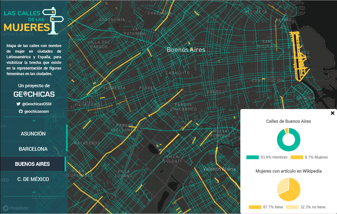
En la mayoría de ciudades, la proporción mujer-hombre está sobre el 15-85%
Y Girona?

Girona
84% H / 16% M
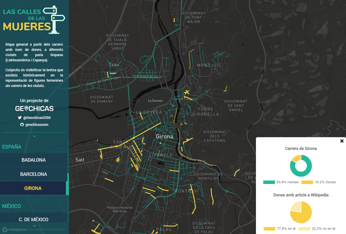
Girona
84% H / 16% M

https://geochicasosm.github.io/lascallesdelasmujeres/
https://github.com/geochicasosm


@geochicasosm
www.geochicas.org
Jessica Sena - @jsenag


