DI Philipp Mitterschiffthaler


Die Erde
Die Erde aus der Sicht des Geodäten...
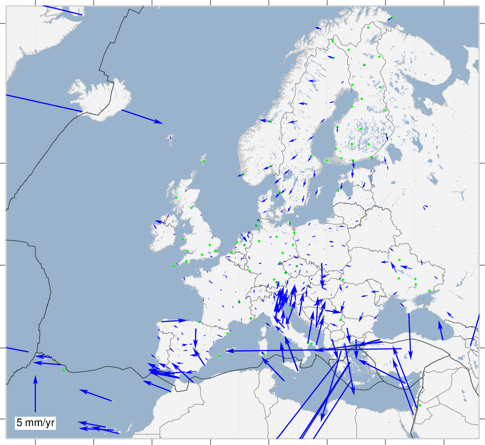
EPN stations horizontal velocities in ITRF2014

EPN stations horizontal velocities in ETRF2014

ETRS in Österreich - horizontal velocities


Definition einer Koordinate

Definition einer Koordinate

Definition einer Koordinate
{
  "features": {
    "type": "FeatureCollection",
    "name": "MyCoordinates_1",
    "features": [
        {},
        {},
        {},
    ],
    "crs": {
        "type": "BEV",
        "name": "MyCRS",
        "properties": {
            "frame": 301,
            "ellipsoid": "EPSG::7004",
            "prime_meridian": "EPSG::8901",
            "projection": "",
            "height_system": "",
            "epoch": 2002.56,
        }
    }
}
Definition einer Koordinate - GeoJSON im BEV Transformator
Beispiel Koordinatentransformation - GRAZ00AUT

Beispiel Koordinatentransformation - GRAZ00AUT

Beispiel Koordinatentransformation - GRAZ00AUT

Beispiel Koordinatentransformation - GRAZ00AUT

Beispiel Koordinatentransformation - GRAZ00AUT

Beispiel Koordinatentransformation - GRAZ00AUT

Beispiel Koordinatentransformation - GRAZ00AUT

Beispiel Koordinatentransformation - GRAZ00AUT

Beispiel Koordinatentransformation - GRAZ00AUT

Beispiel Koordinatentransformation - GRAZ00AUT

MGI

Josefstadt
(Maßstab)
Hundsheimer Berg (Orientierung)
Hermannskogel (Lagerung)

ETRS <-> MGI
ETRS
MGI
7-Parameter-Transformation
{
  dX: -577.326,
  dY: -90.129,
  dZ: -463.919,
  a(x): 5.137'',
  a(y): 1.474'',
  a(z): 5.297'',
  dm: -0.0000024232
}
Genauigkeit < 1.5m
ETRS <-> MGI
ETRS
MGI
GIS Grid

Genauigkeit < 0.15m
GIS Grid
- flächenbasierter Ansatz
- Datumsübergang zwischen ETRS und MGI
- Rasterung 30'' Länge und 45'' Breite (~ 1000m)
- Eingangsdaten 10% der Festpunkte (ohne 6. Ordnung)
- zu ungenau für Katasteranwendungen! Genauigkeit <15cm
- Gitterpunkte in MGI/Bessel!
-
Gridwert (dphi, dlam) in ETRF2000/GRS80!


ETRS <-> MGI
ETRS
MGI
Bestimmung über Passpunkte

Genauigkeit < 0.05m
Höhentransformation

Transformation über Näherungen und Grid-Produkte des BEVs.
Mittlerweile sind sämtliche Grids kostenlos verfügbar!
BEV Transformator
https://transformator.bev.gv.at/at.gv.bev.transformator/austrian
Höhentransformation


Geoid


- flächenbasierter Ansatz
- Datumsübergang von ellipsoidischen Höhen auf orthometrische Höhen
- Rasterung 1.5' Länge und 2.5' Breite (~ 5000m)
- Gridpunkt in MGI/Bessel bzw. ETRF2000/GRS80!
ETRS <-> MGI - lokale Transformation über Passpunkte
ETRS
MGI
1. Schritt:
7-Parameter Transformation und Verebnung in spannungsfreie MGI Koordinaten (x',y',h')
2. Schritt:
Bestimmung von lokalen 4 TransformationsParameter
MGI' (spannungsfrei)
7-Parameter-Transformation
4-Parameter-Bestimmung
Höhengrid

- flächenbasierter Ansatz
- Datumsübergang von orthometrische Höhen auf Gebrauchshöhen
- Rasterung 15'' Länge und 22.5'' Breite (~ 500m)
- Gridpunkt in MGI/Bessel
- Entlang von Nivellementlinien: <0.5 cm
- Mittelgebirge: <2cm
- + Geoidungenauigkeit <3cm
Höhengrid + Geoid

- flächenbasierter Ansatz
- Datumsübergang von ellipsoidischen Höhen auf Gebrauchshöhen
- Rasterung 15'' Länge und 22.5'' Breite (~ 500m)
- Gitterpunkt in MGI/Bessel
- Gridwert in ETRS2000/GRS80
- Entlang von Nivellementlinien: <0.5 cm
- Mittelgebirge: <2cm
Transformationsmöglichkeiten zwischen Frames
