
Who are we?
Syrus Mesdaghi
Technical Lead
syrusm@prominentedge.com
Daniel Berry
dberry@boundlessgeo.com
What will we cover?
- revise
- Goal of Rogue / GeoSHAPE
- GeoSHAPE Components
- GeoGit Integration
- Scalability
- Roadmap
- Q&A
Developed Under ROGUE Project
- Part of a set of capabilities known as GeoSHAPE
- geoshape.org
- github.com/rogue-jctd

- Goal: streamline collaboration on geospatial data between distributed partners
- Since 'partners' can include different government agencies, organizations, volunteer groups
- GeoSHAPE has to be free and open source
- Easy to deploy
- Each partner will have their own instance of GeoSHAPE
- Can edit and synchronize with other instances
- Funded/developed GeoGit (GeoGig)
- Fully operational in disconnected mode
- Can edit and synchronize with other instances
- Includes a mobile app (Arbiter) for data collection

GeoSHAPE Components
MapLoom
Web Editor With GeoGIG integration
github.com/rogue-jctd/maploom

MapLoom
- OpenLayers 3 + Angular + Bootstrap
- Embedded in GeoNode, but can be stand alone
- Bring in layers from local and remote servers
- Supports time dimension
- GeoGIG Integration
- View history of a feature and layer
- View changes in each commit in 2 way diff manner
- Sync with remote GeoGIG repositories
- Conflict resolution in a 3 way diff manner
- Rever commits
- Blame / view authors
- Contribute back!
GeoNode
Manage Layers, Maps, Users & Groups
github.com/GeoNode/geonode/

GeoNode
- Made for users as opposed to GeoServer admins
- Upload / Download Layers
- Save / Open Maps in MapLoom
- Manage Users and profiles
- Manage Groups
- Manage Permissions
- Edit Styles

GeoServer
Serves GIS Vector & Raster data through OGC Standards
github.com/geoserver/geoserver

GeoServer
- It's what does a lot of the heavy lifting
- Supports GIS Data from numerous sources: PostGIS, GeoGIG, SQLite, Shapefile, etc
- Meant more for GIS Administrators

GeoGIG
- De-centralized / Distributed Version Control System
- Does not have to be connected to Server
- Heavily inspired by Git, but had to be rewrite
- Instead of version controlling lines of text, it version geospatial features
- You can commit, pull, push, branch, merge, revert, clone, shallow clone, sparse clone, and many operation which exist in git
- Coming release will rely on Postgres as opposed to the File System
- Only use instead of PostGIS when history of features / layers matter
- github.com/locationtech/geogig

Arbiter
Mobile application for viewing / collecting data
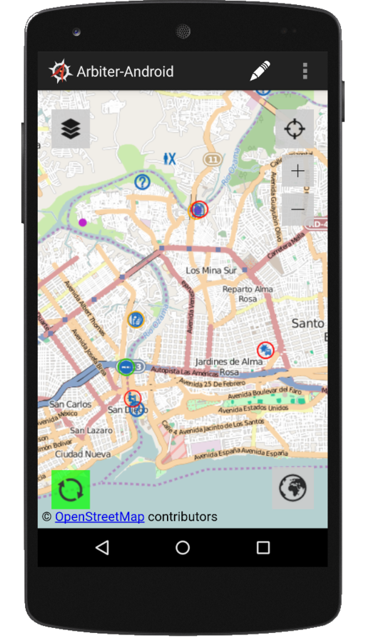
Arbiter
- Mobile application for viewing / collecting Data
- Allows you to easily attach photos to features
- Designed to works in disconnected mode
- It downloads the vector data based on your Area of Interest
- Uses mbtiles for the basemap
- Native Android UI + Open Layers 2
- ...
Demo!
Scalability
- Bullet One
- Bullet Two
- Bullet Three
Roadmap
- Bullet One
- Bullet Two
- Bullet Three