Spatial indexes for OSM in PostGIS
Felix Kunde

https://slides.com/fxku/sotm19
CREATE INDEX pts_spx
ON point_table
USING GIST (geom)
BRIN
SPGIST
< v2.3
< v2.5
GiST
It's a framework
PostGIS > R-Tree
2-nD and kNN support
Leaves
Nodes
Nodes
Root


Level 1
Level 2
Produced with Gevel
ST_Intersects in ms
| tests | 100 k | 1 Mio | 10 Mio | 100 Mio | 1 Bn |
|---|---|---|---|---|---|
| no index | 18.00 | 87.00 | 670 | 6473 | 135529 |
| bulk | 0.21 | 14.00 | 19 | 146 | 1568 |
| online | 0.18 | 15.00 | 29 | 163 | 1672 |
| vacuum | 0.16 | 0.87 | 18 | 145 | 1551 |
| cluster | 0.13 | 0.64 | 16 | 32 | 214 |
BRIN
Block ranges. That's all.
Data should be sorted!
PostGIS > BBox per block
2-4D, no kNN
| ... | time | geom |
|---|---|---|
| ... | 2019-03-13 | POINT(13.8 50) |
| ... | 2019-03-13 | POINT(13.8 50) |
| ... | ... | |
| 2019-03-14 | POINT(13.8 51) | |
| 2019-03-16 | POINT(13.7 51) | |
| ... | ... | |
| ... | 2019-03-16 | POINT(13.7 51) |
| ... | 2019-03-16 | POINT(13.7 51) |
Block Range Index examples
(2019-03-13 09:00:00 , 2019-03-14 11:00:00)
(A-Weg , Grunaer Str.)
BBOX
(2019-03-14 11:15:00 , 2019-03-15 18:00:00)
(Grunaer Weg, Nürnberger Str.)
BBOX
(2019-03-16 09:00:00 , 2019-03-16 17:30:00)
(Oberauer Str. , Zwinglistr.)
BBOX


ORDER BY geom
(PostGIS v3.0 uses Hilbert Curve)
ORDER BY ST_GeoHash(geom)
SET enable_seqscan = false;
(discourage Postgres' query planner to use seq scans)
BRIN vs. GiST
| tests | 100 k | 1 Mio | 10 Mio | 100 Mio | 1 Bn |
|---|---|---|---|---|---|
| create gist | 700 ms | 8 sec | 2 min | 23 min | 6 hrs |
| create brin | 24 ms | 0.2 sec | 2 sec | 18 sec | 90 sec |
| size gist | 5 MB | 50 MB | 500 MB | 5 GB | 50 GB |
| size brin | 24 KB | 24 KB | 48 KB | 376 KB | 3,6 MB |
| duration | x25 | x23 | x1,4 | x1.6 | x1.1 |
sp-GiST
Framework like GIST
Unbalanced tree
No overlaps & prefixes
2-nD, no kNN, yet
https://www.researchgate.net/figure/Adaptive-k-d-tree_fig9_2334587

kd-Tree, Quadtree
Momjian 2019: Flexible Indexing with Postgres [PDF]

Split values between index and leaf nodes

Trick: No Overlap via more dimensions
Each point you see on the map are in fact 4 bounding boxes which are the prefixes of the sp-GiST tree defining the bounds of child quadrants
sp-GiST vs. GiST
| tests | 100 k | 1 Mio | 10 Mio | 100 Mio | 1 Bn |
|---|---|---|---|---|---|
| create gist | 700 ms | 8 sec | 2 min | 23 min | 6 hrs |
| create spgist | 344 ms | 3,7 sec | 50 sec | 11 min | 8 hrs |
| size gist | 5 MB | 50 MB | 500 MB | 5 GB | 50 GB |
| size spgist | 4,5 MB | 44 MB | 440 MB | 4.3 GB | 43 GB |
| duration | x0.85 | x1 | x1 | x1 | x1.1 |
Thematic filters
Multi-column index
Requires btree_gist extension
Spatial column first as it is more selective
Less read from heap
Index will be bigger, combine with ...
CREATE INDEX idx ON planet_osm_point
USING GIST (way, power);
Partial index
CREATE INDEX idx ON planet_osm_point
USING GIST (way)
WHERE power = 'pole';
Covering index
"Payload" only in the leaves (not sorted)
No big speed difference to multi-column index
GiST support in Postgres 12
CREATE INDEX idx ON planet_osm_point
USING GIST (way)
INCLUDE (power);Btw: Index-only scans?
Not possible due to compression
Requires new index tuple format with SRID
For small geoms (Points, BBox, ..?)
Breaking all GiSTs out there?
GeoHash index
BTREE benefits (parallel build, index-only-scan)
Spatial filtering tricky (GeoHash grid)
Slower, so only useful for table clustering
CREATE INDEX idx ON planet_osm_point
USING BTREE (
  ST_GeoHash(ST_Transform(way,4326)), power
)
WHERE power IS NOT NULL;
Radix tree
GeoHash and SPGIST seem like a great fit
LIKE not supported, but can use ranges
Slow (only two prefixes on small dataset)
CREATE INDEX idx ON planet_osm_point
USING SPGIST (
  ST_GeoHash(ST_Transform(way,4326)) text_ops
)
WHERE power IS NOT NULL;
Postgres geometry
Queries need casting but it works
And performance is good (smaller tuple layout)
CREATE INDEX idx ON planet_osm_point
USING SPGIST (
  CAST (way AS point) quad_point_ops
)
WHERE power IS NOT NULL;
SELECT 1 FROM planet_osm_[point|line|polygon]
WHERE CAST(way AS point) <@ [filter-box]
AND _ST_Intersects(way, [filter-buffer]);


SELECT 1 FROM planet_osm_[point|line|polygon]
 WHERE CAST(way AS point) <@ [filter-box];


OSM Experiments


|
|
|||
|---|---|---|---|
| Points | 0.5 Mio, 128 MB, 12% 132, 53, 0.2 MB |
1.7 Mio, 0.4 GB, 13% 96, 92, 0.5 MB |
11.7 Mio, 3 GB, 11% 630, 600, 0.1 MB |
| Lines | 0.5 Mio, 250 MB, 43% 132, 53, 0.2 MB |
2 Mio, 1 GB, 44% 230, 93, 0.6 MB |
14.37 Mio, 7 GB, 42% 1500, 600, 0.2 MB |
| Polygons | 1.2 Mio, 533 MB, 38% 132, 53, 0.2 MB |
5 Mio, 2.3 GB, 39% 560, 220, 0.2 MB |
35.6 Mio, 16 GB, 39% 3800, 1500, 0,5 MB |
Rowcount, Tablesize, Geom. size to table size
sizes of GiST, sp-GiST and BRIN

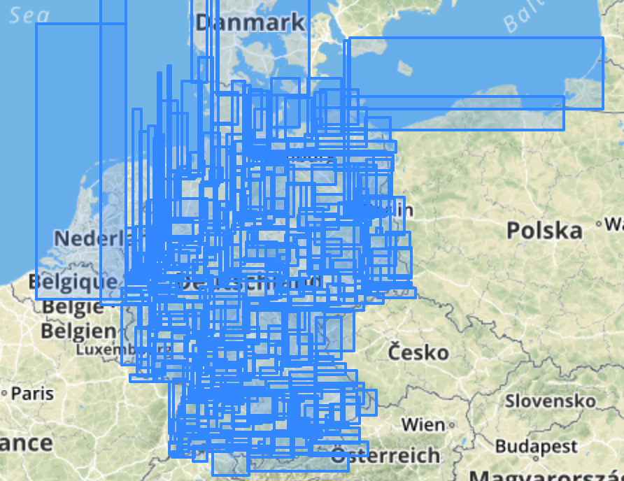
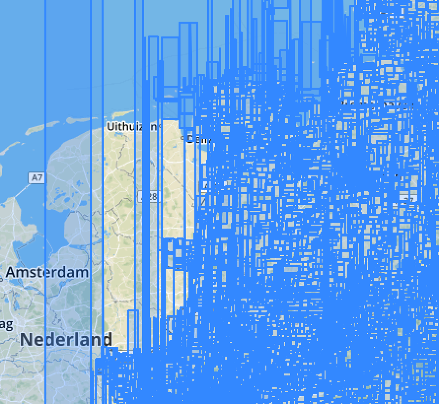

GiST Index on planet_osm_point
Kudos to DBeaver
GiST Index on planet_osm_line


ST_Subdivide me!
GiST Index on planet_osm_polygon


The more data, the closer the gap to BRIN
GiST and sp-GiST comparable on Polygons
sp-GiST slightly faster for points and poylgons
Higher hit-rate of shared buffers (when is this bad?)
highway: emergency_access_point
~ 25.000
highway: motorway
~ 65.000
natural: bare_rock
~ 25.000


CREATE INDEX highway_eap_gist ON planet_osm_point USING GIST (way) WHERE highway = 'emergency_access_point';
CREATE INDEX highway_eap_spgist ON planet_osm_point USING SPGIST (way) WHERE highway = 'emergency_access_point';

EXPLAIN (ANALYZE, Buffers)
SELECT 1 FROM planet_osm_point, random_points
 WHERE ST_Intersects(way,ST_Buffer(geom,1000))
   AND highway = 'emergency_access_point';

GIST

Nested Loop  (cost=0.28..29261.90 rows=83000 width=4) (actual time=0.685..452.657 rows=817 loops=1)
  Buffers: shared hit=21756
  ->  Seq Scan on random_points  (cost=0.00..94.00 rows=10000 width=32) (actual time=0.011..1.977 rows=10000 loops=1)
        Buffers: shared hit=84
  ->  Index Scan using highway_eap_gist on planet_osm_point  (cost=0.28..2.92 rows=1 width=32) (actual time=0.018..0.019 rows=0 loops=10000)
        Index Cond: (way && st_buffer(random_points.geom, '1000'::double precision))
        Filter: _st_intersects(way, st_buffer(random_points.geom, '1000'::double precision))
        Rows Removed by Filter: 0
        Buffers: shared hit=21672
Planning Time: 0.201 ms
Execution Time: 452.791 ms

sp-GIST

Nested Loop  (cost=0.28..29274.00 rows=83000 width=4) (actual time=1.267..362.863 rows=817 loops=1)
  Buffers: shared hit=39917
  ->  Seq Scan on random_points  (cost=0.00..94.00 rows=10000 width=32) (actual time=0.019..1.690 rows=10000 loops=1)
        Buffers: shared hit=84
  ->  Index Scan using highway_eap_spgist on planet_osm_point  (cost=0.28..2.92 rows=1 width=32) (actual time=0.011..0.012 rows=0 loops=10000)
        Index Cond: (way && st_buffer(random_points.geom, '1000'::double precision))
        Filter: _st_intersects(way, st_buffer(random_points.geom, '1000'::double precision))
        Rows Removed by Filter: 0
        Buffers: shared hit=39833
Planning Time: 0.347 ms
Execution Time: 363.027 ms
CREATE INDEX motorway_gist ON planet_osm_line USING GIST (way) WHERE highway = 'motorway';
CREATE INDEX motorway_spgist ON planet_osm_line USING SPGIST (way) WHERE highway = 'motorway';
EXPLAIN (ANALYZE, Buffers)
SELECT 1 FROM planet_osm_line, random_points
WHERE ST_Intersects(way,ST_Buffer(geom,1000))
AND highway = 'motorway';
GIST
Nested Loop (cost=0.28..93512.50 rows=229587 width=4) (actual time=3.490..457.310 rows=3023 loops=1)
Buffers: shared hit=28119
-> Seq Scan on random_points (cost=0.00..94.00 rows=10000 width=32) (actual time=0.007..1.564 rows=10000 loops=1)
Buffers: shared hit=84
-> Index Scan using motorway_gist on planet_osm_line (cost=0.28..9.34 rows=2 width=218) (actual time=0.016..0.024 rows=0 loops=10000)
Index Cond: (way && st_buffer(random_points.geom, '1000'::double precision))
Filter: _st_intersects(way, st_buffer(random_points.geom, '1000'::double precision))
Rows Removed by Filter: 0
Buffers: shared hit=28035
Planning Time: 0.278 ms
Execution Time: 457.651 ms
sp-GIST
Nested Loop (cost=0.28..93497.10 rows=229587 width=4) (actual time=8.248..653.375 rows=3023 loops=1)
Buffers: shared hit=294815
-> Seq Scan on random_points (cost=0.00..94.00 rows=10000 width=32) (actual time=0.010..1.836 rows=10000 loops=1)
Buffers: shared hit=84
-> Index Scan using motorway_spgist on planet_osm_line (cost=0.28..9.34 rows=2 width=218) (actual time=0.032..0.041 rows=0 loops=10000)
Index Cond: (way && st_buffer(random_points.geom, '1000'::double precision))
Filter: _st_intersects(way, st_buffer(random_points.geom, '1000'::double precision))
Rows Removed by Filter: 0
Buffers: shared hit=294731
Planning Time: 0.345 ms
Execution Time: 653.781 msConclusion
& Outlook
Stick with GiST
But give BRIN a try
Use partial indexes
sp-GiST for unbalanced themes
Keep your table stats up-to-date
Questions?
https://slides.com/fxku/sotm19
Used hardware
Tuxedo Infinity Book 13
Intel i7-8550U CPU 1.80GHz
Quadcore, 8 CPUs
32 GB RAM
500GB SSD disk
PostgreSQL config
PostgreSQL 11 & PostGIS 2.5
shared_buffers = 16 GB
work_mem = 128 MB
maintenance_work_mem = 4 GB
min/max_wal_level = 16/4 GB
checpoint_timeout = 30 min
checkpoint_completion_target = 0.9
random_page_cost = 1.1
cpu_tuple_cost = 0.001
cpu_index_tuple_cost = 0.001
effective_cache_size = 24 GB
default_statistics_target = 500
Repo
github.com/FxKu/postgis_indexing
More links
Spatial Indexing for OSM in PostGIS
By fxku
Spatial Indexing for OSM in PostGIS
State of the Map 2019 presentation


