Aerial Mapping Adventures: Drone Workshop
Acme Design is a full service design agency.
— Greg Lang, GISP, Pierce County, WA
WA GIS Association Conference, Tacoma, WA June 13, 2023
— Peter Keum, GISP, King County, WA
Schedule
Part I
Hardware Level
- DJI Mini2
- DJI Mavic 2 Pro
- DJI Mavic 3 Enterprise
1
Automate Flight Apps
- Dronelink
- DroneDeploy
- DJI Pilot2 App
- Pix4D Capture
- MapsMadeEasy - MapPilot
2
Hardware
Mission Planning Software
1.1
Mission Plan & Flight Demo with Mini2 and/or Mavic2 Pro
- Dronelink
- DroneDeploy
3
Demo
Part II
Software App
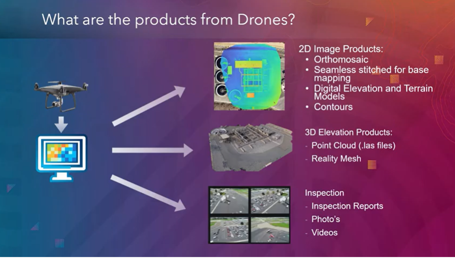
- EPSG./Projection
- 2D aerial map
- 3D Modlel
- Point Cloud
- DEM/Contours
- MapsMadeEasy
5
- AGO Integration
- Repeat Flight Comparison
- Measurements
Data Products
Analysis Topic Examples
1.1
Data Processing Softwares
-
SfM
-
Input Steps
-
GCP
-
Check Points
4
Data Processing
RPAS as Platform
Multi-rotors
Fixed-wing & VTOL

- Shorter flight time (< 45 min)
- Cover smaller area
- Highly maneuverable
- Less expensive
- Access to confined spaces
- Long flight time (+ 40min)
- Covers very large area

(vertical take-off & land)

Remotely Piloted Aircraft System
Sensors Payload

Multi-spectral ~ $10 K
Thermal Infrared ~$8K


High resolution digital camera (100 MP) ~$40K

Lidar Camera
~ $15K
Methane Gas Detector ~$67K


1. Aircraft + Sensor (Data Collection)
2. Data Processing & Analyzing (GIS)
3. Information Products
=
+


Two Spaces for Drone


Outdoor
Indoor
Outdoor
- GPS Signal
- Automated Planning and Flight
- Even, Diffuse lighting
- Open space
Indoor
- No GPS signal
- Limits on speed and motion
- Manual flight control
- Tight spaces
Drone

GIS
Great Combo?
&
Great combo !
GIS & DRONE


Part I
Hardware Level
- DJI Mini2
- DJI Mavic 2 Pro
- DJI Mavic 3 Enterprise
1
Automate Flight Apps
- Dronelink
- DroneDeploy
- DJI Pilot2 App
- Pix4D Capture
- MapsMadeEasy - MapPilot
2
Hardware
Mission Planning Software
1.1
Mission Plan & Flight Demo with Mini2 and/or Mavic2 Pro
- Dronelink
- DroneDeploy
3
Demo
- Low Cost $ ~ $340
- Small form factor <249g
- Fly over people
DJI Mini 2
- Small Sensor 12MP
- Small - Hard to see
- Windy Condition
- Low Flight Height
- Low Flight Time < 20 min
DJI Mini 2

1.2
Part 1.1: Hardware
- Low Cost < $1500
- Good Sensor - 20 MP
- Flight Time ~ 31 min.
- Compatible Mission Planning Software
DJI Mavic 2 Pro
- No Remote ID
- No Firmware Update
- Force into obsolescence
DJI Mavic 2 Pro

1.3
Part 1.1: Hardware

- Good Sensor - 20 MP
- Mechanical Shutter
- Flight Time ~ 46 min.
- Built in Smart Controller
- Small Form Factor
DJI M3 Enterprise
- High Cost $4200
DJI M3 Enterprise


1.4
Part 1.1: Hardware


Flight Control App
- Fly Consistently for overlapping images
- Can fly manually but it's like mowing with scissors


Part 1.2: Mission Planning


Part I
Hardware Level
- DJI Mini2
- DJI Mavic 2 Pro
- DJI Mavic 3 Enterprise
1
Automate Flight Apps
- Dronelink
- DroneDeploy
- DJI Pilot2 App
- Pix4D Capture
- MapsMadeEasy - MapPilot
2
Hardware
Mission Planning Software
1.1
Mission Plan & Flight Demo with Mini2 and/or Mavic2 Pro
- Dronelink
- DroneDeploy
3
Demo
Part II
Software App
- EPSG./Projection
- 2D aerial map
- 3D Modlel
- Point Cloud
- DEM/Contours
- MapsMadeEasy
5
- AGO Integration
- Repeat Flight Comparison
- Measurements
Data Products
Analysis Topic Examples
1.1
Data Processing Softwares
-
SfM/Photogrammetry
-
Input Steps
-
GCP
-
Check Points
4
Data Processing

Structure from Motion (SfM)
Part II: Data Processing

Photogrammetry
Part II: Data Processing

Data Processing

Input Sequences in DD
Ground Control Points


Increase accuracy of drone map

GCP's make your map accurate BUT do not let you know HOW accurate the map is.
Ground Control Points
RTK = Real-Time Kinematic

RTK with Mobile Base Station
RTK with NTRIP


NTRIP - Networked Transport of RTCM (internet protocol).
Require Constant Internet connection (cell) or subscrption
Ground Control Points
GNSS Receivers with RTK +
Esri FieldMap


Importance of Check Points
- Check points are physical markers in drone images where the precise GPS location is known
- Check Points give XYZ error in inches/cm with map products
- Single or average error does not guarantee the accuracy for all parts map
-
GCP = map processing
-
Check Points = calculating average errors

Part II
Software App
- EPSG./Projection
- 2D aerial map
- 3D Modlel
- Point Cloud
- DEM/Contours
5
- AGO Integration
- Repeat Flight Comparison
- Measurements
Data Products
Analysis Topic Examples
1.1
Data Processing Softwares
-
SfM
-
Input Steps
-
GCP
-
Check Points
4
Data Processing
Data Products
EPSG Code - European Petroleum Survey Group
EPSG 4326: WGS 84, Longitude & Latitude Coordinate system
EPSG 3857: Web Mercator Projection (Esri = 1984 Web Mercator Auxiliary Sphere)
EPSG 2926: NAD83 Washington North NAD83


Drone Photo Data
Part II
Software App
- EPSG./Projection
- 2D aerial map
- 3D Modlel
- Point Cloud
- DEM/Contours
5
- AGO Integration
- Repeat Flight Comparison
- Measurements
Data Products
Analysis Topic Examples
1.1
Data Processing Softwares
-
SfM
-
Input Steps
-
GCP
-
Check Points
4
Data Processing
- Esri Dashboard with Survey123
GIS Integration
- AGO Web App


- AGO 3D Scene Viewer App
GIS Integration

DD 3D Model


gdal2tiles.py --profile=mercator -z 1-22 yourmap.tif outputfolder
GIS Integration
- Create web-map using GitHub's gh-page
git checkout gh-pages
git add outputfolder
git commit -m "Yes... TILE DATA"
git push
GIS Integration
DD GeoTiff -> gdal2tile.py -> tile folder


- Email Sign-up
- Resources
- Every 3rd Thursday
- ZOOM Meeting
- 148 Members
Thank You!
Text

WAGISA 2023 Drone Workshop - 6/13/23
By Peter Keum
WAGISA 2023 Drone Workshop - 6/13/23
Presentation slide outline for WA GISA 2023 all day Drone Workshop with Greg L. and Peter K.


