OpenStreetMap
Pavel Tyslacki
pavel.tyslyatksy@gmail.com
@tbicr
Open Data Belarus and OpenStreetMap contributer
About
- Infrastructure
- Plain data
- How mostly it used?
- How we used it?
- How it can be useful?
- How to get involved?
- Why OSM important?
- Why not Google/Yandex?
- Why not Wilimapia?
- OSM community
- OSM Belarus
Infrastructure
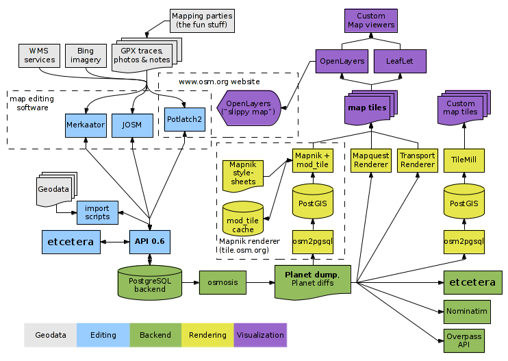
Cycle
Simplify infrastructure scheme
Data -> Editor -> OSM API -> OSM DB -> Data
Types of Data
http://planet.openstreetmap.org/
- data
- dumps
- changes
- gpx
- notes
- tile logs
Plain Data
- point
- latitude, longitude
- tags
- way
- points
- tags
- relation
- members with roles (any)
- tags
- user
- history


Tags
- name=*
- boundary=*
- place=*
- natural=*
- landuse=*
- highway=*
- building=*
- addr:*=*
- shop=*
- amenity=*
- leasure=*
- tourism=*
- sport=*
- more than 55000 tags ...

How mostly it used
- Slippy map (osm.org)
- Offline map (osmand, maps.me, galileo)
- Geocoding
- Search address (osm.org, nominatum, osmand, ...)
- Search name (osm.org, nominatum)
- Navigation/direction (osm.org, project-osrm.org, osmand, maps.me, ...)
How we used it
for opendata.by
- Geocoding
- Create public service division (after geocoding)
- Fix administrative borders
- Get administrative borders (after fixing)
- Search different data (banks, police, ...)
How it can be used
- As in previous examples
- Get geo data (dump, diff, api, services)
- Check theory and dependencies
- Anything with data ...
Tag Info
Average
- Open http://taginfo.openstreetmap.org/
- Select key or tag
- See statistic
- Also exist for countries *.ru, *.fr, *.uk, *.us
Simple
- Open google
- Enter `osm cafe`
- Go to osm wiki (first link)
- Click taginfo
Overpass Turbo
Advanced
- Open http://overpass-turbo.eu/
- Write query (details in help)
- Get map or json or xml
Simple
- Open google
- Enter `osm cafe`
- Go to osm wiki (first link)
- Click overpass-turbo
- Click run
OSM Dump
- Open http://gis-lab.info/projects/osm_dump/
- Download daily updated dump of Belarus
- Process with script or upload to PostGIS
Tools
Examples
How to get involved
You can
- Map with
- Aero or satelete images
- GPS tracks (GPX) (smartphone) -> osm.org
- Photo and video (smartphone) -> mapillary.com
- Other sources ...
- Fix routing
- Fix validators issues
- Improve wiki
Start mapping
- Surroundings
- Grandmother vilage
JOSM
- Watch the video: http://josm.ru/
- Use wiki (popular tags)
- Found your grandmother vilage
- Draw roads
- Draw houses
- Add addresses
Who Did It
- Go http://zverik.osm.rambler.ru/whodidit/
- Zoom
- Click "Get RSS"
- Select place what you want watch
- Click "RSS Link"
- On RSS you can find diff in achavi
OSM issues
-
Threshold of entry
- Newbies
- Editor
- How to
- Community
- Continuous validation
- Imagery
Why OSM important
- It open for usage and editing
- It mostly the best map (especially outside cities)
- bicycle roads
-
It already help
- ambulance (and fire?) cars on call
- on rescue operation after flood or earthquake
Why not Google/Yandex
- Terms of usage
- Thousands requests + limits can be slow
- Can't get or work with pure data (API only)
- Can't fix (or limited?) mistakes or improve
- Mostly worse coverage
Why not Wikimapia
- Unclear data license (used Google Maps)
- Pure editors and other tools
- Category and text description
- 3D mapping?
- Speed limits?
- Turn restrictions?
- Mostly worse coverage
OSM community
- Wiki http://wiki.openstreetmap.org
- BY forum: http://forum.openstreetmap.org/viewforum.php?id=35
- RU forum: http://forum.openstreetmap.org/viewforum.php?id=21
- Email lists
- @openstreetmap
- @shtosm
OSM Belarus
- Mapping
- Belarusian names
- name, name:be, name:ru
- about 25000 unique belarusian names missed
- check http://mlm.jochentopf.com
- Government organisations mapping
- pure contact with community
- bad changes
- POI is pure
- top 3 mobile apps develope guys from Minsk
- http://map.by/
- http://map.nca.by/
Questions
Data around: your home,
your way to work, ...
http://slides.com/paveltyslacki/openstreetmap
Pavel Tyslacki
pavel.tyslyatsky@gmail.com
@tbicr

OpenStreetMap
By Pavel Tyslacki


