Brian Capouch
Quick bio
- Grew up on the Gehring muck farm in Jasper County
- Degrees in Spanish and Agricultural Engineering Technology, fully bilingual English/Spanish
- Have worked as a soils/crop consultant off and on
- Soil will be a focus today
- 34 years teaching Computer Science at Saint Joseph's
- Since retirement, local history and historic restoration
- Currently restoring Sunny Crest, a farm estate in Benton County, and "small farming"
Until I moved onto the edge of the Great Prairie in November 2020, I lived and worked my entire life within the direct confines of the Grand Kankakee Marsh
I also spent many days over many years meandering back and forth near the point where the Second Principal Meridian meets the Kankakee very near here
Plan
- Geological formation and soils
- Removing the Native American population
- Some Potato Creek specialness
- The Huggart Settlement
- "Indian Potatoes"
Timelines are of the essence
I. Geological History
i.e., What caused such a special and unique place?
What do I mean "Kankakee?"
- The Kankakee Valley proper
- Iroquois and Yellow Rivers are tributaries
- Iroquois/Pinkamink "sort of" the same
- Big Monon Creek (tributary of the Tippecanoe)
- Not technically a part, but identical ecologically, and proximate/tangent
Soil-forming forces in nature
- Glacial movement
- Fluvial (Flowing water)
- Lacustrine (Lakebeds)
- Aeolian (Wind)

A plug: The Web Soil Survey

Soils map of area north of Worster Lake
Let's look at some recent history . . .
The Wisconsin glaciation began about 75,000 years ago
Reaching its maximum extent about 22,000 years ago

Each "lobe" of the glacier got a name
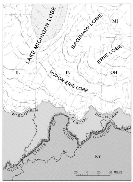
Glaciers advanced and retreated as the climate cooled and warmed
When glaciers stop, they leave end moraines

By this time the glacier's long gone
Materials in inconceivable quantities are moved as till, also creating ground moraines
Ground moraines, also known as till plains, refers to the material under the glacier
It is called "till" because the glaciers act like mammoth bulldozers
Huge amounts of meltwater were discharged below the end moraines
The meltwater carried with it materials swept up by the advance of the glacier
The material moved by glacial drainage is called outwash, and creates outwash plains

A glacier gone as far as it's going to go
N.B. The sandy outwash in the Kankakee Valley is notable for its massive extent
The meltwater also created many glacial lakes
The "lower" banks of glacial lakes were often formed by older end moraines
The Kankakee Torrent was a catastrophic flood ca 19,000 years ago
It was caused by a sudden breach in glacial Lake Chicago, precursor to Lake Michigan
It formed the basins for the later channels of the Kankakee and Illinois rivers
The canyons in Starved Rock State Park were formed by the Torrent

Meltwater then created Lake Kankakee about 14,000 years ago
Its bounds were (roughly) the Valparaiso Moraine to the north, and Iroquois Moraine to the south
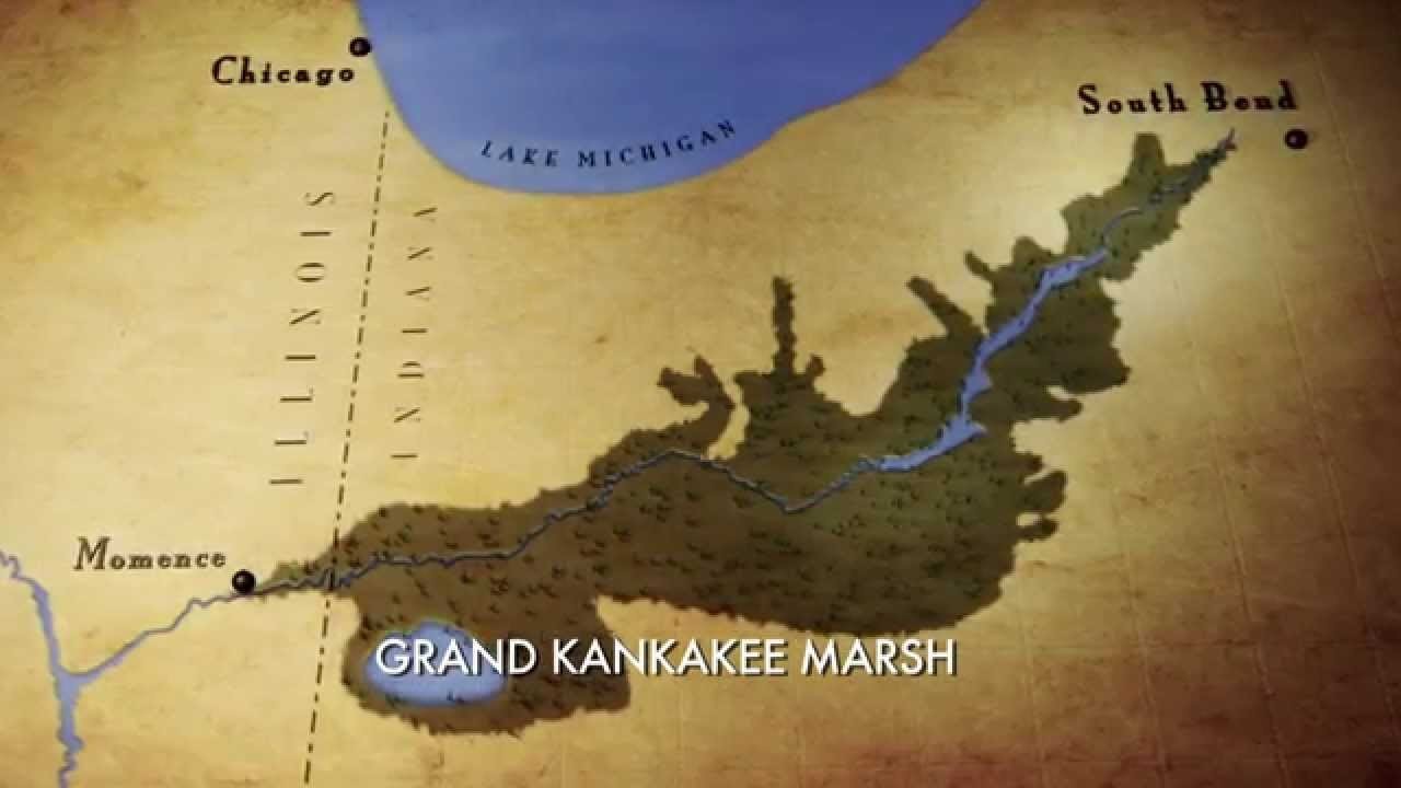
The flat Kankakee's discharge was "dammed" by a limestone ridge near Momence, Illinois
Lake Kankakee drained about 13,000 years ago, after the further retreat of the glaciers


Till plains and outwash plains were both initially scoured of all vegetation
Lack of vegetation left the soil subject to erosion--just like it does now--but far worse
Finer soil particles washed into the lake and "graded" themselves as they settled
Sand dunes formed along the south-ish and east-ish banks of the lake
Summary of specialness
- Geologically recent
- The torrent was responsible for basic shape of basin
-
All four soil-forming processes played a part
- And I found 3 of the 4 for sure here at Potato Creek
- The vast amount of sandy outwash was highly permeable
- The glacial lakebeds were almost flat
- The rock ledge held back the water to create the marsh
Some relevant maps
(This is where the web version shines)
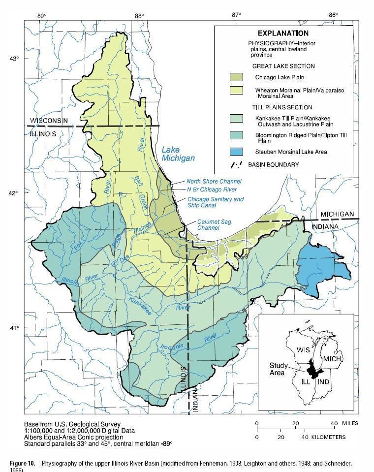
Kankakee and neighboring watersheds
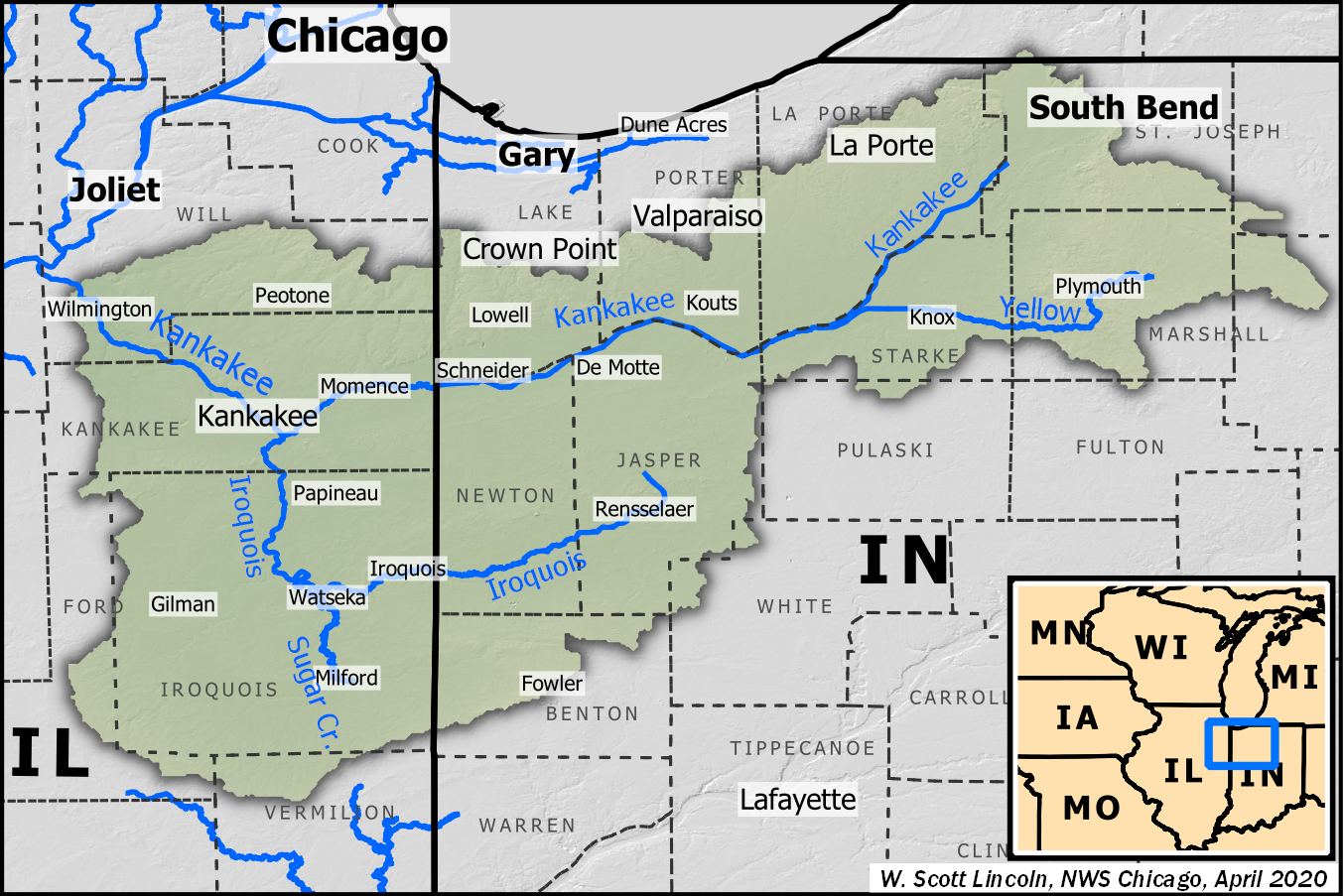
The Kankakee Watershed


Watersheds of the Kankakee and its Tributaries
Kankakee River/Marsh Stats
- Original fall approx 6" per mile
- Over 2000 bends, oxbows, and meanders, etc.
- Approx. 85 miles as the crow flies
- ~250 miles counting all the bends
- Marsh extent 400,000 acres (or more)
- 3-5 miles wide
II. Anthropological History
(Abbreviated Version)

After glacial retreat, a series of native peoples populated the Kankakee Valley
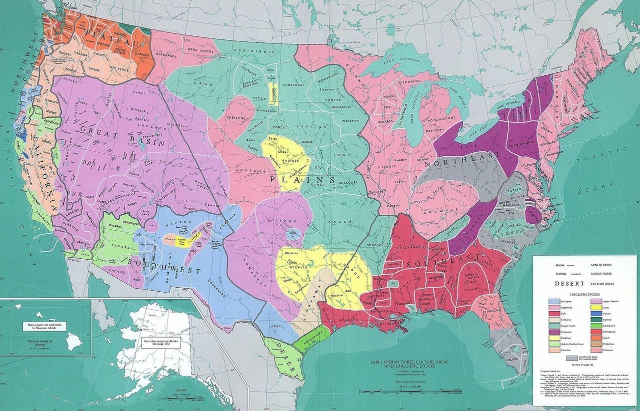
The dominant native people in the Valley were Potawatomi and Miami*
*Dominant during the settlement period
As colonization proceeded, this area was claimed by the French

After the American Revolution the people of the United States looked west to expand
In 1816, Indiana, the then-westernmost state, was admitted, primarily consisting of lands then still belonging to native tribes

Treaties in quick sequence transferred land rights to the new settlers
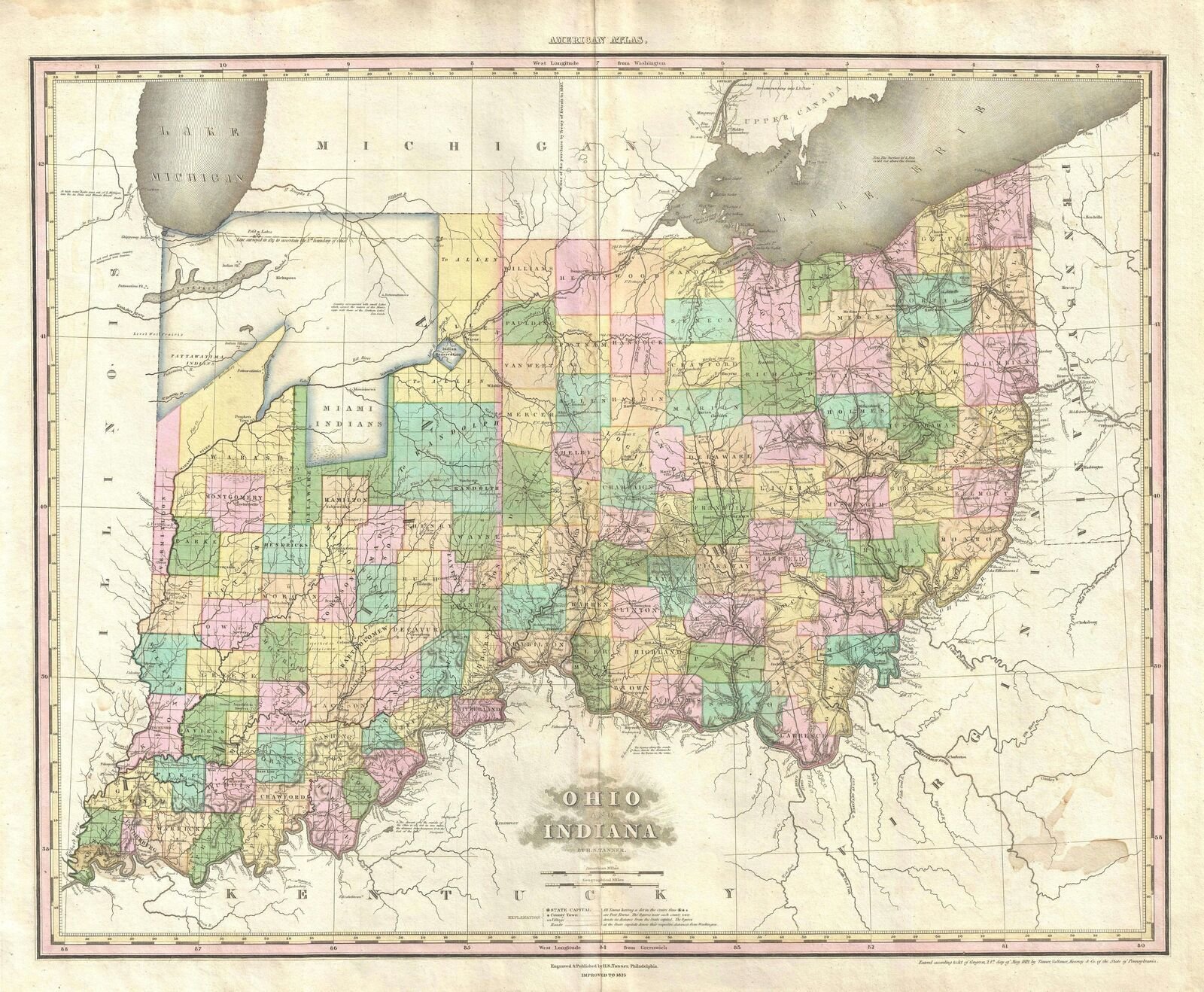
The maps to follow cover 1816-1840

Tanner's maps chronicle the changes


Potato Creek Unique
Porter-Rea Cemetery is a sigificant historical site
The Huggart Settlement
Huggart History
- Samuel applied for land patent in 1834
- No evidence they arrived until ca. 1849
- Born and raised in Virginia
- Samuel was a shoemaker by trade
- Evidence he plied that trade part-time here
- Oldest children born in VA; youngest two in IN
More facts
- Samuel was a charter member of Porter Rea
- Settlement eventually consisted of ~28 people
- Period of residence ca. 1860-1880
- Proof of acceptance by their white community
- Reportedly light-skinned; census recorded them as "mulattos"
- Andrew was the first Black to run for office in St. Joseph County
"It could be said their lives were typical of both Black and white pioneer farmers in the settlement period."
Origin of the name Potato Creek
I have some questions about the accepted explanation
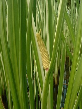
". . . . ingested calamus may be toxic – leading to its commercial ban in the United States."

This plant produces edible tubers that have traditionally been extensively used by Native Americans.

Questions for you to figure out:
Did Native Americans here eat sweet flag?
Are there any signs of either species in any historical record, or present reality?
I hope local folks here will follow up, and document their results based on the scientific method, using accepted research protocols
Potato Creek and the Kankakee: A Historical Perspective
By capouch
Potato Creek and the Kankakee: A Historical Perspective
Slides for a presentation to be given to the Friends of Potato Creek, July 16, 2022


