iiif maps community showcase:
Best practices for associating geographic information with IIIF materials.
stacemaples@stanford.edu
Assistant Director of Geospatial Collections & Services, Stanford Libraries
Founding Co-Chair, iiif+maps Community
Harrison, Richard Edes. U.S. Navy Ships - Bases - Men As of January 1938.
https://www.davidrumsey.com/luna/servlet/iiif/m/RUMSEY~8~1~271937~90045786/manifest

Everything is somewhere, and where matters.
Harrison, Richard Edes. Five Japans : I- Japan is coal and Iron. II- Japan is the Japanese. III- Japan is the land to till. IV- Japan is six cities. V- Japan is Rock and metal.
https://www.davidrumsey.com/luna/servlet/iiif/m/RUMSEY~8~1~316466~90085006/manifest
Map collections are spatial databases, locked in obsolete storage formats (paper)
Harrison, Richard Edes. Gulf Oil.
https://www.davidrumsey.com/luna/servlet/iiif/m/RUMSEY~8~1~290271~90061923/manifest
Historic maps tell us about how the world was made legible at the time
Harrison, Richard Edes. Eight Views Of The World
https://www.davidrumsey.com/luna/servlet/iiif/m/RUMSEY~8~1~266340~5504896/manifest
A bit of history...
(we all like history, right?)
Harrison, Richard Edes. This is Ann ... she drinks blood. Her full name is Anopheles Mosquito
https://www.davidrumsey.com/luna/servlet/iiif/m/RUMSEY~8~1~288913~90060542/manifest
Maps on the internet
1996

1999
Deep Zoom
Mashups
2005
Map Warper
2010
iiif-c
(disclaimer: not the real napkin)
ChatGPT 4o. Prompt: create a xfcd style drawing of the legendary napkin that the idea of iiif the international image interoperability framework was conceived on
2015
iiif + maps
(frustration as motivation)
12 Sunsets: Exploring Ed Ruscha's Archive
2015
Problems to solve:
- Native support in iiif for associated spatial data
- Propagation of derivatives along the continuum from paper to spatial data
- Connecting iiif resources to a rich ecosystem of existing spatial data platforms, APIs and libraries
- Converting paper-based cartographic information into computationally accessible data
Harrison, Richard Edes. Floor of the World Ocean.
https://www.davidrumsey.com/luna/servlet/iiif/m/RUMSEY~8~1~238704~5511617/manifest
iiif+maps mission
- Make spatial data "iiif native"
- Make iiif cartographic resources "spatial data" resources
Harrison, Richard Edes. The Land of P.G. & E. Topography based on model by H.A. Sedelmeyer.
https://www.davidrumsey.com/luna/servlet/iiif/m/RUMSEY~8~1~339625~90107762/manifest
Where iiif+maps is in 2024
Harrison, Richard Edes. The world according to Standard (N.J.) : How a great oil company works in time of peace and how the war is affecting it. Richard Edes Harrison March 1940.
https://www.davidrumsey.com/luna/servlet/iiif/m/RUMSEY~8~1~278301~90051691/manifest
navPlace extension
navPlace addresses the need to associate geography with iiif resources,
whether they are maps, or not!
navPlace makes iiif spatial metadata accessible to broadly accepted mapping platforms, APIs & libraries...
(like leaflet.js, openlayers.js, etc...)
Play with navPlace here!
navPlace makes iiif spatial metadata accessible to broadly accepted mapping libraries
(like leaflet.js, openlayers.js, etc...)
Play with navPlace here!
navPlace accommodates complex geometries
ImagineRio.org uses navPlace for complex visualizations of spatial context!
navPlace is GeoJSON-LD
for the spatial context of your iiif objects
obligatory scary code slide
{
  "@context": [
    "http://www.w3.org/ns/anno.jsonld",
    "http://iiif.io/api/presentation/3/context.json",
    "http://iiif.io/api/extension/navplace/context.json"
  ],
  "id": "https://purl.stanford.edu/mk032vx9771/iiif3/manifest",
  "label": {
    "en": [
      "... Attack on Amstelveen Oct. 1787"
    ]
  },
  "requiredStatement": {
    "label": {
      "en": [
        "Attribution"
      ]
    },
    "value": {
      "en": [
        "Provided by the Stanford University Libraries"
      ]
    }
  },
  "logo": [
    {
      "id": "https://stacks.stanford.edu/image/iiif/wy534zh7137/SULAIR_rosette/full/400,/0/default.jpg",
      "type": "Image",
      "service": [
        {
          "id": "https://stacks.stanford.edu/image/iiif/wy534zh7137/SULAIR_rosette",
          "type": "ImageService2",
          "profile": "http://iiif.io/api/image/2/level2.json"
        }
      ]
    }
  ],
  "seeAlso": [
    {
      "id": "https://purl.stanford.edu/mk032vx9771.mods",
      "type": "Metadata",
      "format": "application/mods+xml"
    }
  ],
  "navPlace": {
    "id": "/feature-collection/1",
    "type": "FeatureCollection",
    "features": [
      {
        "id": "/iiif/feature/1",
        "type": "Feature",
        "properties": {
        },
        "geometry": {
          "type": "Polygon",
          "coordinates": [
            [
              [
                "4.794444",
                "52.330555"
              ],
              [
                "4.908888",
                "52.330555"
              ],
              [
                "4.908888",
                "52.241666"
              ],
              [
                "4.794444",
                "52.241666"
              ],
              [
                "4.794444",
                "52.330555"
              ]
            ]
          ]
        }
      }
    ]
  },
  "type": "Manifest",
  "metadata": [
    {
      "label": {
        "en": [
          "Available Online"
        ]
      },
      "value": {
        "en": [
          "<a href='https://purl.stanford.edu/mk032vx9771'>https://purl.stanford.edu/mk032vx9771</a>"
        ]
      }
    },
    {
      "label": {
        "en": [
          "Title"
        ]
      },
      "value": {
        "en": [
          "... Attack on Amstelveen Oct. 1787"
        ]
      }
    },
    {
      "label": {
        "en": [
          "Type"
        ]
      },
      "value": {
        "en": [
          "map",
          "government publication",
          "cartographic image",
          "Maps",
          "Early maps"
        ]
      }
    },
    {
      "label": {
        "en": [
          "Format"
        ]
      },
      "value": {
        "en": [
          "1 map (MS) : color touches ; map 42 x 24 cm; Overall size 48 x 64 cm",
          "unmediated"
        ]
      }
    },
    {
      "label": {
        "en": [
          "Language"
        ]
      },
      "value": {
        "en": [
          "und"
        ]
      }
    },
    {
      "label": {
        "en": [
          "Description"
        ]
      },
      "value": {
        "en": [
          "Shows Amstelveen.",
          "Period: 18th century.",
          "Collector's note: Extensive text in Dutch."
        ]
      }
    },
    {
      "label": {
        "en": [
          "Subject"
        ]
      },
      "value": {
        "en": [
          "Military maps",
          "Mil 3561"
        ]
      }
    },
    {
      "label": {
        "en": [
          "Coverage"
        ]
      },
      "value": {
        "en": [
          "Netherlands",
          "Amstelveen (Netherlands)",
          "E 4°47'40\"--E 4°54'32\"/N 52°19'50\"--N 52°14'30\""
        ]
      }
    },
    {
      "label": {
        "en": [
          "Date"
        ]
      },
      "value": {
        "en": [
          "17uu-||||",
          "between 1700 and 1799"
        ]
      }
    },
    {
      "label": {
        "en": [
          "Publisher"
        ]
      },
      "value": {
        "en": [
          "[publisher not identified]"
        ]
      }
    },
    {
      "label": {
        "en": [
          "Identifier"
        ]
      },
      "value": {
        "en": [
          "https://purl.stanford.edu/mk032vx9771"
        ]
      }
    },
    {
      "label": {
        "en": [
          "Relation"
        ]
      },
      "value": {
        "en": [
          "Koeman: Vol. III, p. 180 , Map numbers 138, 139, 140",
          "Antiquarian Maps Collection"
        ]
      }
    },
    {
      "label": {
        "en": [
          "PublishDate"
        ]
      },
      "value": {
        "en": [
          "2024-05-08T11:35:28Z"
        ]
      }
    }
  ],
  "summary": {
    "en": [
      "Shows Amstelveen."
    ]
  },
  "viewingDirection": "left-to-right",
  "thumbnail": [
    {
      "type": "Image",
      "id": "https://stacks.stanford.edu/image/iiif/mk032vx9771/mk032vx9771_00_0001/full/!400,400/0/default.jpg",
      "format": "image/jpeg",
      "service": [
        {
          "id": "https://stacks.stanford.edu/image/iiif/mk032vx9771/mk032vx9771_00_0001",
          "type": "ImageService2",
          "profile": "http://iiif.io/api/image/2/level2.json"
        }
      ],
      "width": 400,
      "height": 305
    }
  ],
  "items": [
    {
      "type": "Canvas",
      "id": "https://purl.stanford.edu/mk032vx9771/iiif3/canvas/cocina-fileSet-mk032vx9771-713b97dc-4f02-4f35-8856-739deacee6a7",
      "label": {
        "en": [
          "Image 1"
        ]
      },
      "height": 12313,
      "width": 16166,
      "items": [
        {
          "type": "AnnotationPage",
          "id": "https://purl.stanford.edu/mk032vx9771/iiif3/annotation_page/cocina-fileSet-mk032vx9771-713b97dc-4f02-4f35-8856-739deacee6a7",
          "items": [
            {
              "type": "Annotation",
              "motivation": "painting",
              "id": "https://purl.stanford.edu/mk032vx9771/iiif3/annotation/cocina-fileSet-mk032vx9771-713b97dc-4f02-4f35-8856-739deacee6a7",
              "target": "https://purl.stanford.edu/mk032vx9771/iiif3/canvas/cocina-fileSet-mk032vx9771-713b97dc-4f02-4f35-8856-739deacee6a7",
              "body": {
                "type": "Image",
                "id": "https://stacks.stanford.edu/image/iiif/mk032vx9771/mk032vx9771_00_0001/full/full/0/default.jpg",
                "format": "image/jpeg",
                "height": 12313,
                "width": 16166,
                "service": [
                  {
                    "id": "https://stacks.stanford.edu/image/iiif/mk032vx9771/mk032vx9771_00_0001",
                    "type": "ImageService2",
                    "profile": "http://iiif.io/api/image/2/level2.json"
                  }
                ]
              }
            }
          ]
        }
      ]
    }
  ]
}
navPlace can be inline
(for simple bounding boxes, and point locations)
obligatory less scary code slide
  "navPlace": {
    "id": "/feature-collection/1",
    "type": "FeatureCollection",
    "features": [
      {
        "id": "/iiif/feature/1",
        "type": "Feature",
        "properties": {
        },
        "geometry": {
          "type": "Polygon",
          "coordinates": [
            [
              [
                "4.794444",
                "52.330555"
              ],
              [
                "4.908888",
                "52.330555"
              ],
              [
                "4.908888",
                "52.241666"
              ],
              [
                "4.794444",
                "52.241666"
              ],
              [
                "4.794444",
                "52.330555"
              ]
            ]
          ]
        }
      }
    ]
  }
navPlace can be referenced
(for complex geographies)
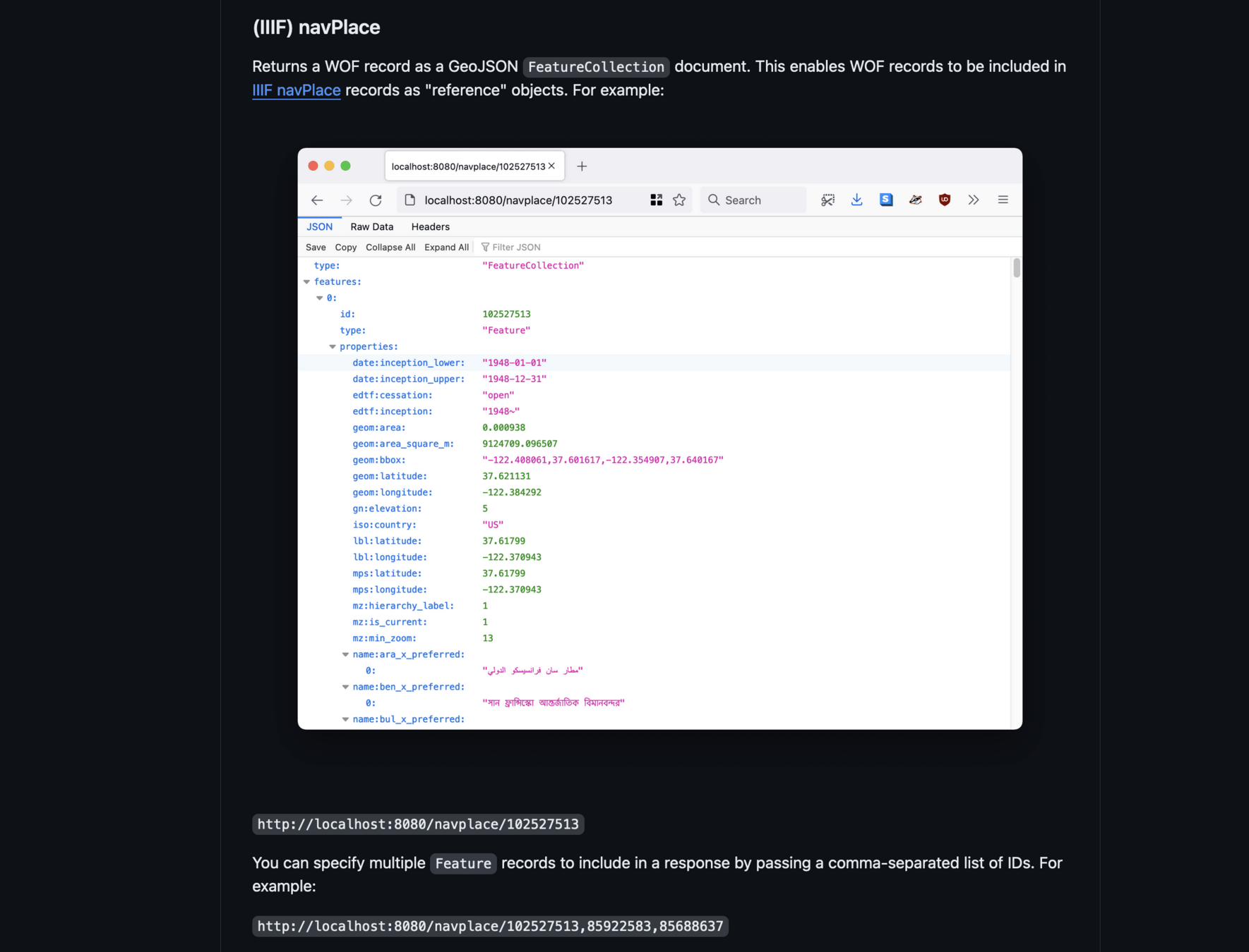
Who's on First supports navPlace!!!
https://spelunker.whosonfirst.org/navplace/85925383
https://github.com/whosonfirst/go-whosonfirst-browser#iiif-navplace
Aeronautical view of the Panama Canal:
Blacklight: AllMaps Plugin
https://github.com/bplmaps/blacklight-allmaps
Geo4LibCamp24 AllMaps Plugin Presentation and Implementation Workshop
AllMaps XYZ Tile Server
(use georeferenced iiif maps virtually any spatial platform, API or library!)
Play Allmaps Arcade!
Test your ability to put historic maps where they belong in the world!
Get involved!
navPlace addresses the need to associate geography with iiif resources,
whether they are maps, or not!
Harrison, Richard Edes. The Big Network. How the World Communications System reaches into the U.S.
https://www.davidrumsey.com/luna/servlet/iiif/m/RUMSEY~8~1~337543~90105616/manifest
Georeference any map at a iiif endpoint, with AllMaps.org!
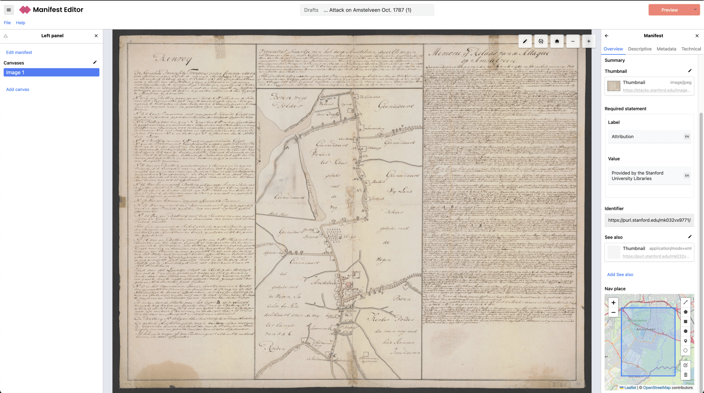
Add navPlace to your iiif manifests with Manifest Editor
Join us on iiif.slack.com
in the #maps channel!
Harrison, Richard Edes. Africa in maps. Richard Edes Harrison, Sept. 1941. (on verso text) Africa. Photographs from Richard U. Light and Mary Light, "Focus on Africa" American Geographical Society of New York, 1941. (inset).
https://www.davidrumsey.com/luna/servlet/iiif/m/RUMSEY~8~1~274101~90047832/manifest
iiif+maps Community Meetings are on the iiif Calendar!
(the next one is Wednesday, June 26th, at 8am Pacific!)
Harrison, Richard Edes. China (Seen from the direction of Guam)
https://www.davidrumsey.com/luna/servlet/iiif/m/RUMSEY~8~1~289485~90061017/manifest
Thank You!
Harrison, Richard Edes. The world divided. Richard Edes Harrison, July 1941. The world centrifuged : North - Polar Azmuthal Equidistant Projection.
https://www.davidrumsey.com/luna/servlet/iiif/m/RUMSEY~8~1~274103~90047834/manifest
Want to know more about Richard Edes Harrison? Check out:
Susan Schulten, University of Denver: How Richard Edes Harrison Mapped Information

Take these slides home!
iiif Maps Showcase 2024
By Stace Maples


