Using open source tools to create vector tile and webmap
November 1, 2017
Peter Keum
King County WTD GIS Specialist
SeattleMaptime


CUGOS
Using open source tools to create vector tile basemaps
Using open source tools to create web map
Creating web maps with vector tiles
Vector tiles and the future of web maps

Another new new thing???

Doing is Learning, but...

Doing it badly?

It's still learning!
Raster
- Image format
- Styled before loading
- Specific zoom levels
Vector
- Protobuf format, includes geo data
- Syled after loading
- Unlimited zoom level
Map Tiles
Raster Tiles
- Don't Scale
- Hard to change
- Just Pictures, not data


Power of Vector Tiles
Five County Parcels Polygons
- King, Pierce, Snohomish, Island, Kitsap
- 1.2 million polygons
- shp 730 MB -> 90 MB vector tiles
WA Building Footprints - 1 million buildings
- Source: 9.8 million building by Microsoft hand digitized footprint with heights
Quick Demo

WHOA!
Vector Tiles
language-neutral, platform-neutral extensible mechanism for encoding structred data"

Similar to xml except smaller, faster and simpler
.pbf or .mvt
Vector Tiles
Similar to raster tile except it returns vector representation of feature in the tile.

- Scales
- Easy to change
- Smart data

Easy to Change!
Smart Data!
Raster & Vector Tiles

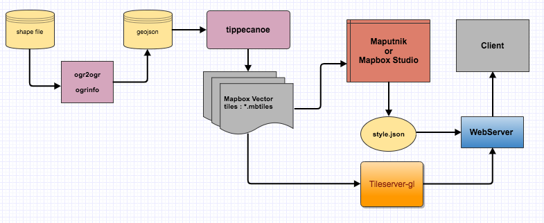
Preparing
Data
Creating
Vector Tiles
Styling/Rendering
Vector Tiles
Preparing Data
Geospatial Data Abstraction Library
Command line utilies for data processing and data translation
How to convert shp to geojson
Creating Vector Tiles
Command-line Utility tool to convert custom data to vector tiles
GeoJSON --> *.mbtiles
Styling Vector Tiles
Free visual style editor for designer and developers
Commercial visual style editor for designer and developers + so much more...
Rendering Vector Tiles
Open Source Vector Tile server with options
Preparing
Data
Creating
Vector Tiles
Styling Vector Tiles
Rendering Vector Tiles

"First do it, then do it right, then do it better."

THANK YOU!
peter.keum@kingcounty.gov
@pkeum
github.com/keum
MaptimeSeattle - Vector tiles and web map
By Peter Keum
MaptimeSeattle - Vector tiles and web map
Modified version of original WA URISA Tacoma, WA - May 17, 2017 for UW Tacoma's MS Geospatial Class. Presentation on creating vector tiled basemap using open source tools. using local data to generate vector tiles and create webmap. Using gdal/ogr, tippecanoe and tileserver-gl server to create and serve vector data and web map.


