INTRO O
PROBLEM SOLVING AND
PROGRAMMING IN PYTHON
(use the Space key to navigate through all slides)
|
Prof. Andrea Gallegati |
Prof. Dario Abbondanza |

CIS 1051 - GeoJSON
Overpass turbo
Query example
[out:json];
(
  // Get all buildings (nodes, ways,
  // and relations)

  relation["building"]( {{bbox}} );

  // Get all highways (streets, including
  // pedestrian paths)

  relation["highway"]( {{bbox}} );
);
out geom;
Just the Nodes
[out:json];
(
  // Get all buildings (nodes, ways,
  // and relations)

  relation["building"]( {{bbox}} );

  // Get all highways (streets, including
  // pedestrian paths)

  relation["highway"]( {{bbox}} );
);
out geom;
{
"type": "FeatureCollection",
"generator": "overpass-turbo",
"copyright": "The data included in this document is from www.openstreetmap.org. The data is made available under ODbL.",
"timestamp": "2025-02-09T16:22:30Z",
"features": [
{
"type": "Feature",
"properties": {
"@id": "node/25388116",
"crossing": "traffic_signals",
"highway": "crossing"
},
"geometry": {
"type": "Point",
"coordinates": [
12.4629478,
41.9023645
]
},
"id": "node/25388116"
},
{
"type": "Feature",
"properties": {
"@id": "node/25388119",
"highway": "traffic_signals",
"source": "mapillary",
"traffic_signals": "signal"
},
"geometry": {
"type": "Point",
"coordinates": [
12.4665261,
41.899504
]
},
"id": "node/25388119"
},
{
"type": "Feature",
"properties": {
"@id": "node/25388203",
"crossing": "uncontrolled",
"crossing:markings": "zebra",
"highway": "crossing"
},
"geometry": {
"type": "Point",
"coordinates": [
12.4722851,
41.9009026
]
},
"id": "node/25388203"
},
{
"type": "Feature",
"properties": {
"@id": "node/25388392",
"crossing": "zebra",
"crossing:island": "yes",
"crossing:markings": "zebra",
"highway": "crossing",
"tactile_paving": "no"
},
"geometry": {
"type": "Point",
"coordinates": [
12.4763873,
41.8945513
]
},
"id": "node/25388392"
},
{
"type": "Feature",
"properties": {
"@id": "node/25418915",
"highway": "traffic_signals",
"traffic_signals": "signal",
"traffic_signals:direction": "forward"
},
"geometry": {
"type": "Point",
"coordinates": [
12.4998175,
41.9008288
]
},
"id": "node/25418915"
},
{
"type": "Feature",
"properties": {
"@id": "node/25418916",
"direction": "both",
"highway": "traffic_signals",
"railway": "tram_level_crossing"
},
"geometry": {
"type": "Point",
"coordinates": [
12.4992668,
41.9003165
]
},
"id": "node/25418916"
},
{
"type": "Feature",
"properties": {
"@id": "node/25418918",
"highway": "traffic_signals",
"traffic_signals": "signal",
"traffic_signals:direction": "both"
},
"geometry": {
"type": "Point",
"coordinates": [
12.4980573,
41.8992075
]
},
"id": "node/25418918"
},
{
"type": "Feature",
"properties": {
"@id": "node/25418925",
"crossing": "uncontrolled",
"crossing:island": "no",
"crossing:markings": "zebra",
"crossing_ref": "zebra",
"highway": "crossing",
"tactile_paving": "yes"
},
"geometry": {
"type": "Point",
"coordinates": [
12.4936304,
41.8950574
]
},
"id": "node/25418925"
},
{
"type": "Feature",
"properties": {
"@id": "node/25418931",
"crossing": "uncontrolled",
"crossing:island": "no",
"crossing:markings": "zebra",
"crossing_ref": "zebra",
"highway": "crossing",
"tactile_paving": "no"
},
"geometry": {
"type": "Point",
"coordinates": [
12.4921625,
41.8943885
]
},
"id": "node/25418931"
},
{
"type": "Feature",
"properties": {
"@id": "node/25643620",
"highway": "traffic_signals",
"traffic_signals:direction": "both"
},
"geometry": {
"type": "Point",
"coordinates": [
12.5070116,
41.9027733
]
},
"id": "node/25643620"
},
{
"type": "Feature",
"properties": {
"@id": "node/25643630",
"crossing": "marked",
"crossing:markings": "zebra",
"crossing_ref": "zebra",
"highway": "crossing"
},
"geometry": {
"type": "Point",
"coordinates": [
12.5068648,
41.9034276
]
},
"id": "node/25643630"
},
{
"type": "Feature",
"properties": {
"@id": "node/25643643",
"highway": "traffic_signals"
},
"geometry": {
"type": "Point",
"coordinates": [
12.5054854,
41.9062237
]
},
"id": "node/25643643"
},
{
"type": "Feature",
"properties": {
"@id": "node/25643645",
"button_operated": "yes",
"crossing": "traffic_signals",
"highway": "crossing",
"tactile_paving": "yes",
"traffic_signals:sound": "yes",
"traffic_signals:vibration": "yes"
},
"geometry": {
"type": "Point",
"coordinates": [
12.5046647,
41.908063
]
},
"id": "node/25643645"
},
{
"type": "Feature",
"properties": {
"@id": "node/26618751",
"button_operated": "no",
"crossing": "traffic_signals",
"crossing_ref": "zebra",
"highway": "traffic_signals",
"tactile_paving": "no",
"traffic_signals:sound": "no",
"traffic_signals:vibration": "no"
},
"geometry": {
"type": "Point",
"coordinates": [
12.5159689,
41.891428
]
},
"id": "node/26618751"
},
{
"type": "Feature",
"properties": {
"@id": "node/26619087",
"highway": "traffic_signals"
},
"geometry": {
"type": "Point",
"coordinates": [
12.5095474,
41.8950438
]
},
"id": "node/26619087"
},
{
"type": "Feature",
"properties": {
"@id": "node/32630064",
"crossing": "traffic_signals",
"crossing:markings": "zebra",
"crossing:signals": "yes",
"crossing_ref": "zebra",
"highway": "crossing",
"tactile_paving": "no"
},
"geometry": {
"type": "Point",
"coordinates": [
12.4843817,
41.8808332
]
},
"id": "node/32630064"
},
{
"type": "Feature",
"properties": {
"@id": "node/32630958",
"crossing": "uncontrolled",
"crossing:island": "no",
"crossing:markings": "zebra",
"crossing_ref": "zebra",
"highway": "crossing",
"tactile_paving": "yes"
},
"geometry": {
"type": "Point",
"coordinates": [
12.4810904,
41.8945737
]
},
"id": "node/32630958"
},
{
"type": "Feature",
"properties": {
"@id": "node/32641633",
"highway": "traffic_signals",
"traffic_signals": "signal"
},
"geometry": {
"type": "Point",
"coordinates": [
12.4909766,
41.9058649
]
},
"id": "node/32641633"
},
{
"type": "Feature",
"properties": {
"@id": "node/32641661",
"crossing": "uncontrolled",
"highway": "crossing"
},
"geometry": {
"type": "Point",
"coordinates": [
12.4831333,
41.9131897
]
},
"id": "node/32641661"
},
{
"type": "Feature",
"properties": {
"@id": "node/32649911",
"button_operated": "no",
"crossing": "traffic_signals",
"crossing_ref": "zebra",
"highway": "crossing",
"tactile_paving": "no",
"traffic_signals:sound": "no",
"traffic_signals:vibration": "no"
},
"geometry": {
"type": "Point",
"coordinates": [
12.4742106,
41.8894649
]
},
"id": "node/32649911"
},
{
"type": "Feature",
"properties": {
"@id": "node/32650381",
"highway": "traffic_signals"
},
"geometry": {
"type": "Point",
"coordinates": [
12.4805457,
41.8908966
]
},
"id": "node/32650381"
},
{
"type": "Feature",
"properties": {
"@id": "node/32651022",
"crossing": "uncontrolled",
"crossing:island": "no",
"crossing:markings": "zebra",
"crossing_ref": "zebra",
"highway": "crossing",
"tactile_paving": "no"
},
"geometry": {
"type": "Point",
"coordinates": [
12.4994487,
41.8972971
]
},
"id": "node/32651022"
},
{
"type": "Feature",
"properties": {
"@id": "node/38226069",
"highway": "traffic_signals"
},
"geometry": {
"type": "Point",
"coordinates": [
12.496524,
41.8670832
]
},
"id": "node/38226069"
},
{
"type": "Feature",
"properties": {
"@id": "node/83506907",
"crossing": "zebra",
"crossing:island": "yes",
"crossing:markings": "yes",
"crossing_ref": "zebra",
"highway": "crossing",
"was:highway": "crossing"
},
"geometry": {
"type": "Point",
"coordinates": [
12.4818504,
41.8937489
]
},
"id": "node/83506907"
},
{
"type": "Feature",
"properties": {
"@id": "node/83650214",
"highway": "traffic_signals",
"traffic_signals": "signal",
"traffic_signals:direction": "forward"
},
"geometry": {
"type": "Point",
"coordinates": [
12.4751324,
41.8928542
]
},
"id": "node/83650214"
},
{
"type": "Feature",
"properties": {
"@id": "node/83651419",
"crossing": "zebra",
"crossing:island": "no",
"crossing:markings": "zebra",
"highway": "crossing",
"tactile_paving": "no"
},
"geometry": {
"type": "Point",
"coordinates": [
12.4804935,
41.8923572
]
},
"id": "node/83651419"
},
{
"type": "Feature",
"properties": {
"@id": "node/93810168",
"highway": "traffic_signals"
},
"geometry": {
"type": "Point",
"coordinates": [
12.5180619,
41.8879387
]
},
"id": "node/93810168"
},
{
"type": "Feature",
"properties": {
"@id": "node/93810173",
"highway": "traffic_signals",
"traffic_signals": "signal"
},
"geometry": {
"type": "Point",
"coordinates": [
12.5220926,
41.8849954
]
},
"id": "node/93810173"
},
{
"type": "Feature",
"properties": {
"@id": "node/93810175",
"highway": "traffic_signals",
"traffic_signals": "signal"
},
"geometry": {
"type": "Point",
"coordinates": [
12.5228824,
41.8836908
]
},
"id": "node/93810175"
},
{
"type": "Feature",
"properties": {
"@id": "node/93810184",
"highway": "traffic_signals",
"traffic_signals": "signal"
},
"geometry": {
"type": "Point",
"coordinates": [
12.5218125,
41.8794863
]
},
"id": "node/93810184"
},
{
"type": "Feature",
"properties": {
"@id": "node/101042174",
"crossing": "traffic_signals",
"highway": "crossing"
},
"geometry": {
"type": "Point",
"coordinates": [
12.493101,
41.8814018
]
},
"id": "node/101042174"
},
{
"type": "Feature",
"properties": {
"@id": "node/101142277",
"crossing": "zebra",
"crossing:markings": "zebra",
"highway": "crossing"
},
"geometry": {
"type": "Point",
"coordinates": [
12.4903114,
41.882188
]
},
"id": "node/101142277"
},
{
"type": "Feature",
"properties": {
"@id": "node/101172809",
"crossing": "zebra",
"highway": "crossing",
"tactile_paving": "incorrect"
},
"geometry": {
"type": "Point",
"coordinates": [
12.5030693,
41.8873863
]
},
"id": "node/101172809"
},
{
"type": "Feature",
"properties": {
"@id": "node/101172817",
"crossing": "zebra",
"highway": "crossing"
},
"geometry": {
"type": "Point",
"coordinates": [
12.495295,
41.8861661
]
},
"id": "node/101172817"
},
{
"type": "Feature",
"properties": {
"@id": "node/101172839",
"crossing": "zebra",
"highway": "crossing"
},
"geometry": {
"type": "Point",
"coordinates": [
12.4947507,
41.8869866
]
},
"id": "node/101172839"
},
{
"type": "Feature",
"properties": {
"@id": "node/101181731",
"highway": "motorway_junction",
"name": "A24"
},
"geometry": {
"type": "Point",
"coordinates": [
12.5305427,
41.901548
]
},
"id": "node/101181731"
},
{
"type": "Feature",
"properties": {
"@id": "node/101181735",
"highway": "motorway_junction",
"name": "A24"
},
"geometry": {
"type": "Point",
"coordinates": [
12.5290468,
41.9000474
]
},
"id": "node/101181735"
},
{
"type": "Feature",
"properties": {
"@id": "node/122546577",
"highway": "traffic_signals"
},
"geometry": {
"type": "Point",
"coordinates": [
12.4565926,
41.90025
]
},
"id": "node/122546577"
},
{
"type": "Feature",
"properties": {
"@id": "node/122548652",
"crossing": "zebra",
"highway": "crossing"
},
"geometry": {
"type": "Point",
"coordinates": [
12.4521263,
41.8989278
]
},
"id": "node/122548652"
},
{
"type": "Feature",
"properties": {
"@id": "node/122552836",
"crossing": "zebra",
"crossing:island": "no",
"crossing:markings": "zebra",
"highway": "crossing"
},
"geometry": {
"type": "Point",
"coordinates": [
12.4505747,
41.9004584
]
},
"id": "node/122552836"
},
{
"type": "Feature",
"properties": {
"@id": "node/122559866",
"crossing": "uncontrolled",
"crossing:island": "no",
"highway": "crossing",
"tactile_paving": "no"
},
"geometry": {
"type": "Point",
"coordinates": [
12.4605772,
41.8947862
]
},
"id": "node/122559866"
},
{
"type": "Feature",
"properties": {
"@id": "node/122561842",
"highway": "traffic_signals"
},
"geometry": {
"type": "Point",
"coordinates": [
12.4622985,
41.8996206
]
},
"id": "node/122561842"
},
{
"type": "Feature",
"properties": {
"@id": "node/122561924",
"crossing": "uncontrolled",
"crossing:island": "no",
"crossing:markings": "zebra",
"crossing_ref": "zebra",
"highway": "crossing",
"tactile_paving": "no",
"wheelchair": "limited"
},
"geometry": {
"type": "Point",
"coordinates": [
12.4620144,
41.9023366
]
},
"id": "node/122561924"
},
{
"type": "Feature",
"properties": {
"@id": "node/122568740",
"direction": "both",
"highway": "traffic_signals"
},
"geometry": {
"type": "Point",
"coordinates": [
12.4992168,
41.9078749
]
},
"id": "node/122568740"
},
{
"type": "Feature",
"properties": {
"@id": "node/122571137",
"highway": "traffic_signals",
"traffic_signals": "signal"
},
"geometry": {
"type": "Point",
"coordinates": [
12.5063171,
41.8943652
]
},
"id": "node/122571137"
},
{
"type": "Feature",
"properties": {
"@id": "node/130221077",
"crossing": "uncontrolled",
"highway": "crossing"
},
"geometry": {
"type": "Point",
"coordinates": [
12.488831,
41.8702999
]
},
"id": "node/130221077"
},
{
"type": "Feature",
"properties": {
"@id": "node/130221093",
"crossing": "traffic_signals",
"highway": "traffic_signals"
},
"geometry": {
"type": "Point",
"coordinates": [
12.4890205,
41.8688924
]
},
"id": "node/130221093"
},
{
"type": "Feature",
"properties": {
"@id": "node/130670833",
"crossing": "uncontrolled",
"crossing:markings": "zebra",
"crossing:signals": "no",
"highway": "crossing",
"tactile_paving": "no"
},
"geometry": {
"type": "Point",
"coordinates": [
12.4641962,
41.9092434
]
},
"id": "node/130670833"
},
{
"type": "Feature",
"properties": {
"@id": "node/130695995",
"button_operated": "no",
"crossing": "traffic_signals",
"highway": "traffic_signals",
"tactile_paving": "no",
"traffic_signals:sound": "no",
"traffic_signals:vibration": "no"
},
"geometry": {
"type": "Point",
"coordinates": [
12.455303,
41.9087149
]
},
"id": "node/130695995"
},
{
"type": "Feature",
"properties": {
"@id": "node/130733900",
"crossing": "zebra",
"highway": "crossing",
"tactile_paving": "no"
},
"geometry": {
"type": "Point",
"coordinates": [
12.4561036,
41.9156235
]
},
"id": "node/130733900"
},
{
"type": "Feature",
"properties": {
"@id": "node/139109274",
"highway": "traffic_signals"
},
"geometry": {
"type": "Point",
"coordinates": [
12.4717092,
41.9145727
]
},
"id": "node/139109274"
},
{
"type": "Feature",
"properties": {
"@id": "node/153452466",
"crossing": "uncontrolled",
"crossing:island": "no",
"crossing:markings": "zebra",
"crossing_ref": "zebra",
"highway": "crossing",
"tactile_paving": "no"
},
"geometry": {
"type": "Point",
"coordinates": [
12.453172,
41.906924
]
},
"id": "node/153452466"
},
{
"type": "Feature",
"properties": {
"@id": "node/153473920",
"highway": "traffic_signals"
},
"geometry": {
"type": "Point",
"coordinates": [
12.4555857,
41.9075488
]
},
"id": "node/153473920"
},
{
"type": "Feature",
"properties": {
"@id": "node/153531493",
"highway": "traffic_signals"
},
"geometry": {
"type": "Point",
"coordinates": [
12.4544785,
41.9121428
]
},
"id": "node/153531493"
},
{
"type": "Feature",
"properties": {
"@id": "node/153531502",
"highway": "traffic_signals"
},
"geometry": {
"type": "Point",
"coordinates": [
12.4531641,
41.9118235
]
},
"id": "node/153531502"
},
{
"type": "Feature",
"properties": {
"@id": "node/153531513",
"highway": "traffic_signals"
},
"geometry": {
"type": "Point",
"coordinates": [
12.4494506,
41.9108978
]
},
"id": "node/153531513"
},
{
"type": "Feature",
"properties": {
"@id": "node/153548382",
"highway": "traffic_signals"
},
"geometry": {
"type": "Point",
"coordinates": [
12.4546921,
41.9113072
]
},
"id": "node/153548382"
},
{
"type": "Feature",
"properties": {
"@id": "node/153548394",
"highway": "traffic_signals"
},
"geometry": {
"type": "Point",
"coordinates": [
12.4581553,
41.9121728
]
},
"id": "node/153548394"
},
{
"type": "Feature",
"properties": {
"@id": "node/195379564",
"highway": "crossing"
},
"geometry": {
"type": "Point",
"coordinates": [
12.4719672,
41.9122118
]
},
"id": "node/195379564"
},
{
"type": "Feature",
"properties": {
"@id": "node/195386423",
"highway": "crossing"
},
"geometry": {
"type": "Point",
"coordinates": [
12.4726491,
41.9118391
]
},
"id": "node/195386423"
},
{
"type": "Feature",
"properties": {
"@id": "node/205187560",
"button_operated": "yes",
"crossing": "traffic_signals",
"highway": "crossing",
"kerb": "lowered",
"tactile_paving": "no",
"traffic_signals:sound": "no",
"traffic_signals:vibration": "no"
},
"geometry": {
"type": "Point",
"coordinates": [
12.4751054,
41.9050116
]
},
"id": "node/205187560"
},
{
"type": "Feature",
"properties": {
"@id": "node/208733152",
"highway": "traffic_signals"
},
"geometry": {
"type": "Point",
"coordinates": [
12.5376724,
41.89911
]
},
"id": "node/208733152"
},
{
"type": "Feature",
"properties": {
"@id": "node/208740804",
"highway": "crossing"
},
"geometry": {
"type": "Point",
"coordinates": [
12.5313021,
41.8964792
]
},
"id": "node/208740804"
},
{
"type": "Feature",
"properties": {
"@id": "node/224166720",
"highway": "traffic_signals"
},
"geometry": {
"type": "Point",
"coordinates": [
12.4488382,
41.9093944
]
},
"id": "node/224166720"
},
{
"type": "Feature",
"properties": {
"@id": "node/224166730",
"highway": "traffic_signals",
"supervised": "yes"
},
"geometry": {
"type": "Point",
"coordinates": [
12.4489994,
41.9093094
]
},
"id": "node/224166730"
},
{
"type": "Feature",
"properties": {
"@id": "node/224166756",
"highway": "traffic_signals"
},
"geometry": {
"type": "Point",
"coordinates": [
12.4512352,
41.9137706
]
},
"id": "node/224166756"
},
{
"type": "Feature",
"properties": {
"@id": "node/224166819",
"highway": "traffic_signals"
},
"geometry": {
"type": "Point",
"coordinates": [
12.4511672,
41.9138423
]
},
"id": "node/224166819"
},
{
"type": "Feature",
"properties": {
"@id": "node/224335371",
"crossing": "zebra",
"highway": "crossing",
"supervised": "no"
},
"geometry": {
"type": "Point",
"coordinates": [
12.4573591,
41.9155038
]
},
"id": "node/224335371"
},
{
"type": "Feature",
"properties": {
"@id": "node/224335512",
"crossing": "zebra",
"highway": "crossing"
},
"geometry": {
"type": "Point",
"coordinates": [
12.461353,
41.9150806
]
},
"id": "node/224335512"
},
{
"type": "Feature",
"properties": {
"@id": "node/224423587",
"crossing": "zebra;uncontrolled",
"highway": "crossing"
},
"geometry": {
"type": "Point",
"coordinates": [
12.4591002,
41.9148844
]
},
"id": "node/224423587"
},
{
"type": "Feature",
"properties": {
"@id": "node/224423782",
"highway": "traffic_signals",
"traffic_signals": "signal"
},
"geometry": {
"type": "Point",
"coordinates": [
12.4626462,
41.9135375
]
},
"id": "node/224423782"
},
{
"type": "Feature",
"properties": {
"@id": "node/224559544",
"highway": "traffic_signals"
},
"geometry": {
"type": "Point",
"coordinates": [
12.4687482,
41.9120265
]
},
"id": "node/224559544"
},
{
"type": "Feature",
"properties": {
"@id": "node/224632801",
"highway": "traffic_signals"
},
"geometry": {
"type": "Point",
"coordinates": [
12.4645161,
41.9141495
]
},
"id": "node/224632801"
},
{
"type": "Feature",
"properties": {
"@id": "node/224849982",
"highway": "traffic_signals"
},
"geometry": {
"type": "Point",
"coordinates": [
12.4473968,
41.9100955
]
},
"id": "node/224849982"
},
{
"type": "Feature",
"properties": {
"@id": "node/245550406",
"highway": "crossing"
},
"geometry": {
"type": "Point",
"coordinates": [
12.5275941,
41.8882647
]
},
"id": "node/245550406"
},
{
"type": "Feature",
"properties": {
"@id": "node/245551361",
"crossing": "traffic_signals",
"highway": "crossing"
},
"geometry": {
"type": "Point",
"coordinates": [
12.5276614,
41.8887437
]
},
"id": "node/245551361"
},
{
"type": "Feature",
"properties": {
"@id": "node/245551396",
"highway": "traffic_signals"
},
"geometry": {
"type": "Point",
"coordinates": [
12.5236097,
41.8897799
]
},
"id": "node/245551396"
},
{
"type": "Feature",
"properties": {
"@id": "node/246063924",
"crossing": "uncontrolled",
"highway": "crossing"
},
"geometry": {
"type": "Point",
"coordinates": [
12.5234588,
41.8813832
]
},
"id": "node/246063924"
},
{
"type": "Feature",
"properties": {
"@id": "node/246065477",
"crossing": "zebra",
"highway": "crossing"
},
"geometry": {
"type": "Point",
"coordinates": [
12.5137061,
41.8812732
]
},
"id": "node/246065477"
},
{
"type": "Feature",
"properties": {
"@id": "node/246066904",
"highway": "traffic_signals"
},
"geometry": {
"type": "Point",
"coordinates": [
12.5217052,
41.875815
]
},
"id": "node/246066904"
},
{
"type": "Feature",
"properties": {
"@id": "node/246067530",
"highway": "traffic_signals"
},
"geometry": {
"type": "Point",
"coordinates": [
12.5149884,
41.8844978
]
},
"id": "node/246067530"
},
{
"type": "Feature",
"properties": {
"@id": "node/246067951",
"crossing": "uncontrolled",
"crossing:markings": "zebra",
"highway": "crossing"
},
"geometry": {
"type": "Point",
"coordinates": [
12.5103809,
41.8813224
]
},
"id": "node/246067951"
},
{
"type": "Feature",
"properties": {
"@id": "node/246068404",
"crossing": "uncontrolled",
"crossing:markings": "zebra",
"highway": "crossing",
"tactile_paving": "yes"
},
"geometry": {
"type": "Point",
"coordinates": [
12.5157319,
41.8818676
]
},
"id": "node/246068404"
},
{
"type": "Feature",
"properties": {
"@id": "node/246069116",
"crossing": "marked",
"crossing:island": "no",
"highway": "crossing"
},
"geometry": {
"type": "Point",
"coordinates": [
12.5177402,
41.8817338
]
},
"id": "node/246069116"
},
{
"type": "Feature",
"properties": {
"@id": "node/246073276",
"crossing": "uncontrolled",
"crossing:island": "no",
"highway": "crossing",
"tactile_paving": "no"
},
"geometry": {
"type": "Point",
"coordinates": [
12.5208994,
41.8830826
]
},
"id": "node/246073276"
},
{
"type": "Feature",
"properties": {
"@id": "node/246074077",
"crossing:markings": "zebra",
"highway": "crossing"
},
"geometry": {
"type": "Point",
"coordinates": [
12.513684,
41.8847818
]
},
"id": "node/246074077"
},
{
"type": "Feature",
"properties": {
"@id": "node/246114500",
"highway": "traffic_signals"
},
"geometry": {
"type": "Point",
"coordinates": [
12.5075147,
41.875486
]
},
"id": "node/246114500"
},
{
"type": "Feature",
"properties": {
"@id": "node/246114502",
"button_operated": "no",
"crossing": "traffic_signals",
"highway": "traffic_signals",
"tactile_paving": "no",
"traffic_signals:sound": "no",
"traffic_signals:vibration": "no"
},
"geometry": {
"type": "Point",
"coordinates": [
12.5081413,
41.8768007
]
},
"id": "node/246114502"
},
{
"type": "Feature",
"properties": {
"@id": "node/246116132",
"highway": "traffic_signals"
},
"geometry": {
"type": "Point",
"coordinates": [
12.5067996,
41.8745805
]
},
"id": "node/246116132"
},
{
"type": "Feature",
"properties": {
"@id": "node/246121547",
"crossing": "traffic_signals",
"crossing_ref": "zebra",
"highway": "traffic_signals"
},
"geometry": {
"type": "Point",
"coordinates": [
12.5149723,
41.8888399
]
},
"id": "node/246121547"
}
]
}Try it out!
... let's have a look at the GeoJSON
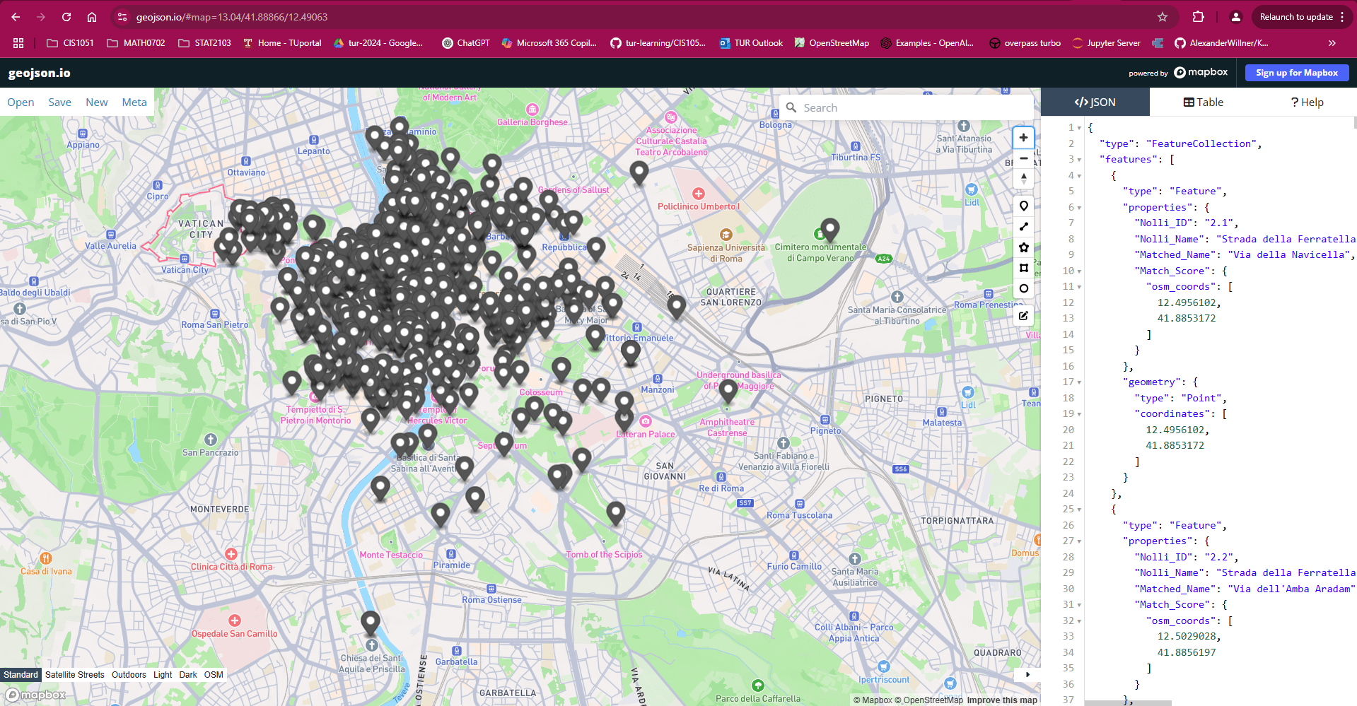
Hands-on
Let's now find together the nearest drinking water to a given monument
Now it's your turn
Explore the Nolli map of Rome (1748)
This was crafted with
![]()
A Framework created by Hakim El Hattab and contributors
to make stunning HTML presentations
geo-json
By Andrea Gallegati

