


Introduction
In October, 2020, The Town of Dedham, City of Boston, the Boston Planning and Development Agency, The Metropolitan Area Planning Council, and the Central Transportation Planning Staff undertook this Corridor Action Plan to reimagine the future of the VFW Parkway - Providence Highway Corridor.
The Corridor Action Plan consisted of two main goals:
- Develop an Action Plan to transform the car-centric corridor into a route for everyone and meet the needs of local residents, local businesses, bicyclists, pedestrians, and transit riders, as well as motorists.
- Craft short- and long-term recommendations for safe access to shops, schools, neighborhoods, transit, and recreational areas—including the Charles River and Mother Brook.
Explore the project website on the right or click here to visit the website in a new tab
Project Area
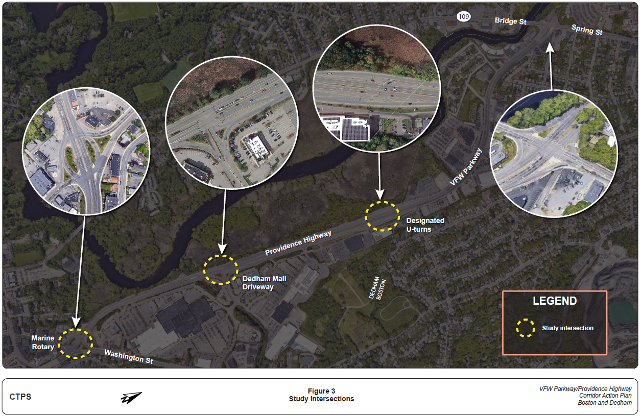
Below, you can view an interactive map of the project area that splits the area into three segments. The map also marks three separate locations that CTPS considered for specific analysis: Marine Rotary, Dedham Mall Driveway, and the currently designated U-turn area.
Check out the project timeline to the left. Recommendation drafting has been ongoing since July 2021
Project Area
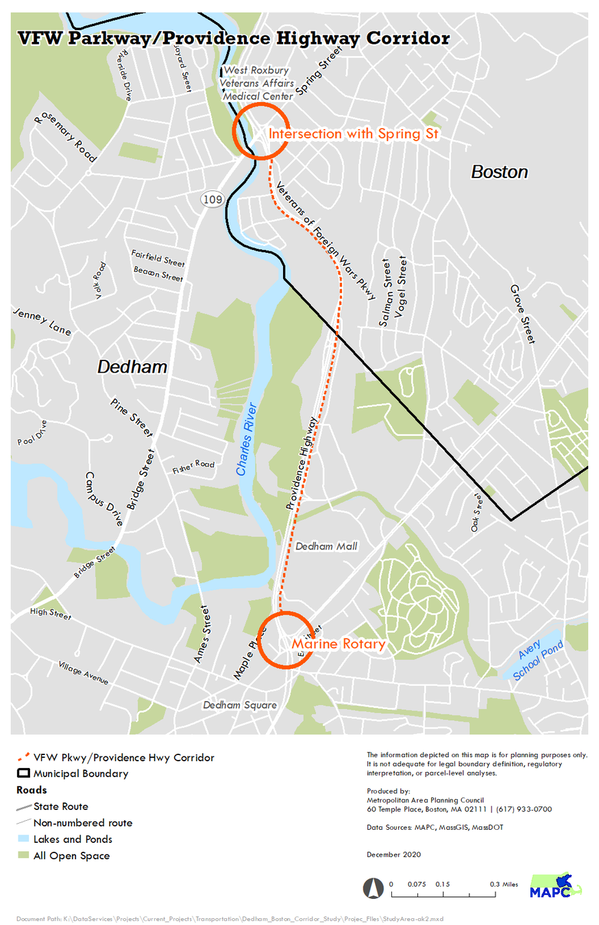
The below map spotlights the three intersections analyzed in this Action Plan with the addition of the Spring Street intersection. The Spring Street intersection was not considered in this project because MassDOT and the City of Boston are developing a plan to improve this intersection separate from this planning process. Click the image to enlarge.
What have we done so far?
CTPS and MAPC completed a detailed needs assessment and technical analysis of the corridor combining community feedback with data ranging from average weekday traffic counts, to management and circulation data across modes, to ADA compliance issues. A full list of data sources, as well as identified needs, can be found on the project website.
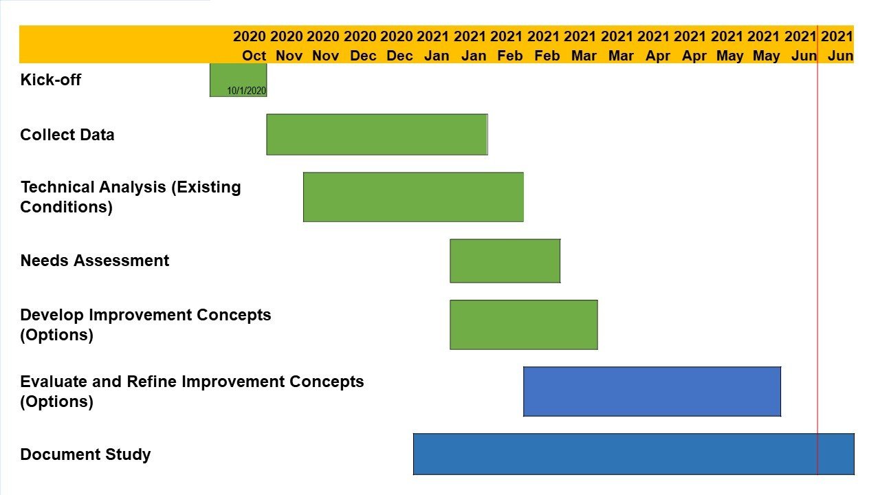
Check out the project timeline to the right. Recommendation drafting has been ongoing since July 2021
Existing Conditions
The Providence Highway in Dedham and West Roxbury has almost no accommodations for pedestrians, bicyclists, or transit riders, making it unsafe and unfriendly for people walking, biking, taking public transit, or using assistive mobility devices. Traffic is regularly congested during peak travel times. The map below compares traffic volume in the corridor (left) and corridor spot speeds (right). In the speed map, the blue number is the average speed, red the 85th percentile speed, and green the existing speed limit (45 mph).
-
Peak periods are from 1:00 PM to 6:00 PM in both northbound and southbound directions.
-
The PM peak period traffic has much higher volumes because trips such as shopping also coincide with work-related rush hour trips.
Existing Conditions: Crash Data
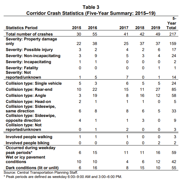
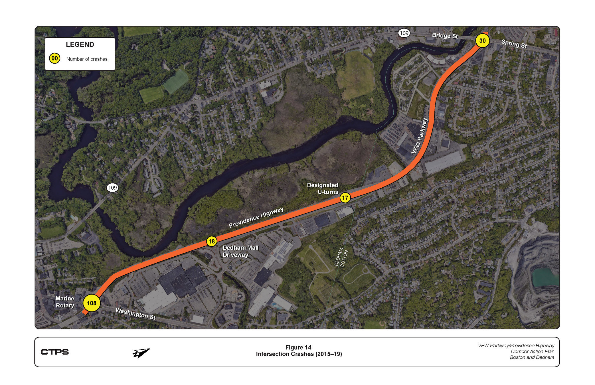
During the five-year analysis period (2015–19), 217 crashes were recorded in the corridor. Some characteristics of the crashes include: approximately 50% of the crashes occurred at Marine Rotary, 30 percent of crashes resulted in injury to at least one of the involved parties, 27% of crashes took place during peak periods (defined as 6:00-9:00 AM and 3:00-6:00 PM), and five crashes involved people walking or biking. The table on the next slide summarizes crashes across the study area. The map on the next page shows the location of crashes.
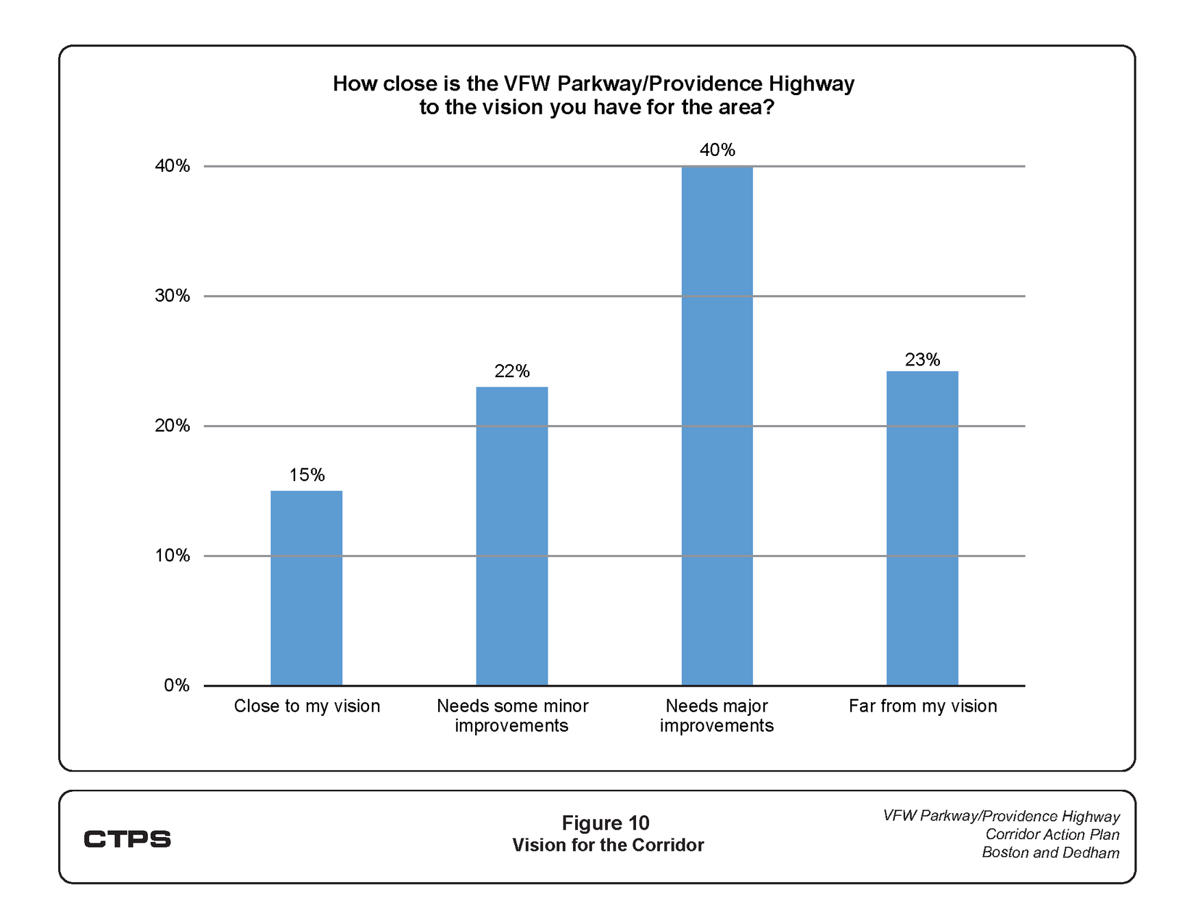
Community Perceptions
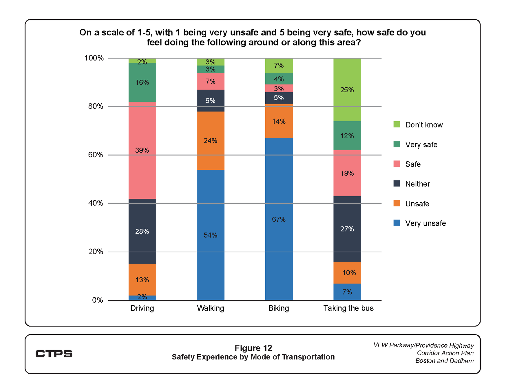
The consensus of community participants was that the corridor needed significant improvements. The first chart indicates that eighty-five percent of the respondents to the community survey believe the existing conditions are not close to their vision for the corridor. The second chart indicates that while around half of identified drivers felt safe, the overwhelming majority of other mode users felt very unsafe navigating the corridor.
Community Perceptions
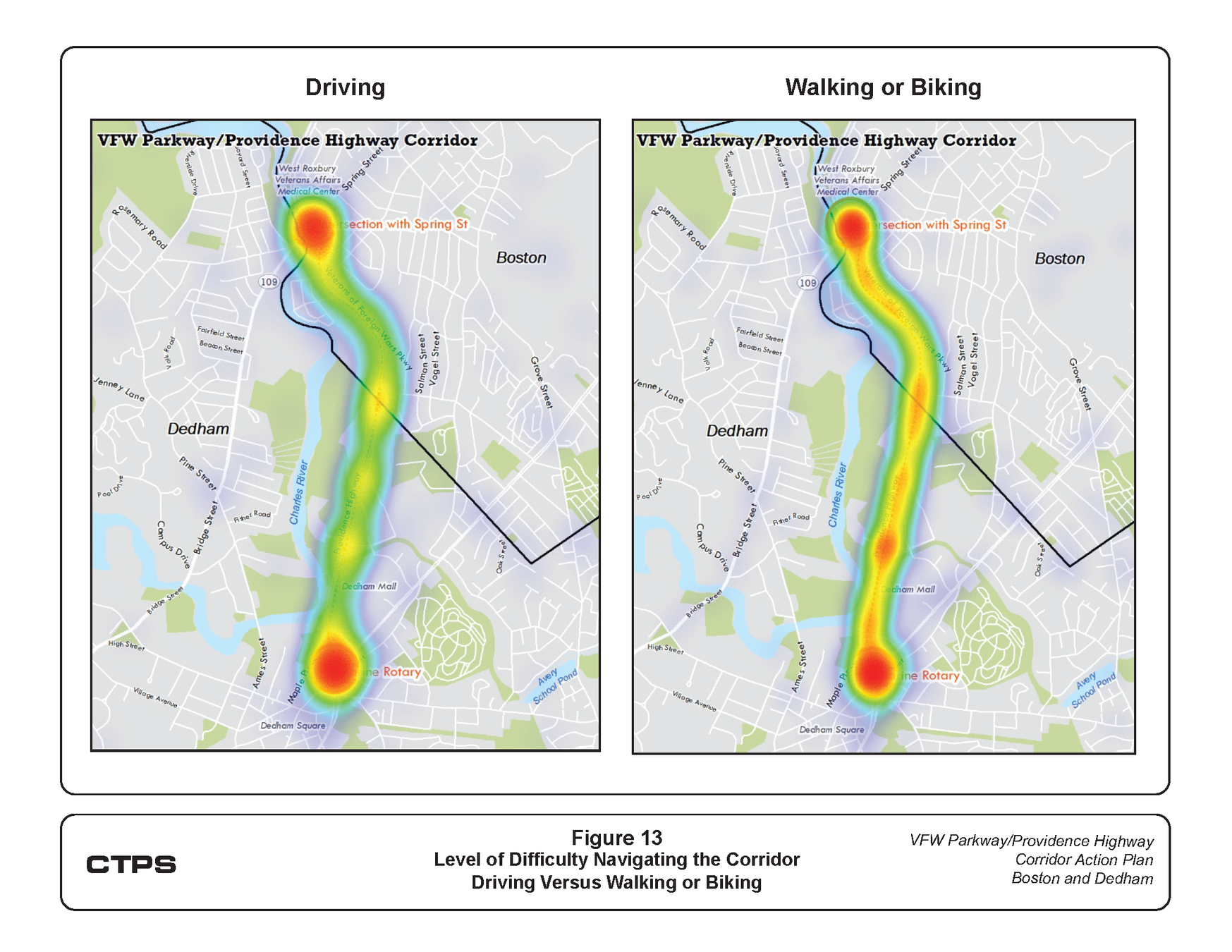
Community members identified Marine Rotary, and the VFW Parkway and Spring Street intersections as choke points and difficult to navigate. The maps below, taken from the survey, illustrate areas of concern for driving and for walking or biking as identified by participants.
Long-Term Improvements
Long-term improvements typically require design and engineering efforts and larger funding resources and can take between five and 15 years to implement.
These improvements will modernize the automobile-centric corridor into a roadway that connects people to places and provides safe access to schools, recreational areas, neighborhoods, and transit; increase safety for people who walk, bicycle, or ride the bus; and support livable communities and economic vitality.
Note: these concepts are proposals. they are not guaranteed to be implemented
Marine Rotary
CTPS envisions two potential long-term solutions for the Marine Rotary area in Dedham: a modern roundabout (Concept 1, left) and a signalized intersection (Concept 2, right). Each concept has accommodations for pedestrians and cyclists but performs slightly differently in peak hours, with the signalized intersection performing slightly better.
Providence Highway Segment 1
CTPS envisions two potential long-term concepts for the first segment of Providence Highway, which stretches from the Marine Rotary to the Dedham Mall Driveway. The left image highlights the area of Segment 1. Use the Google Streetview on the right to explore the area as it looks currently.
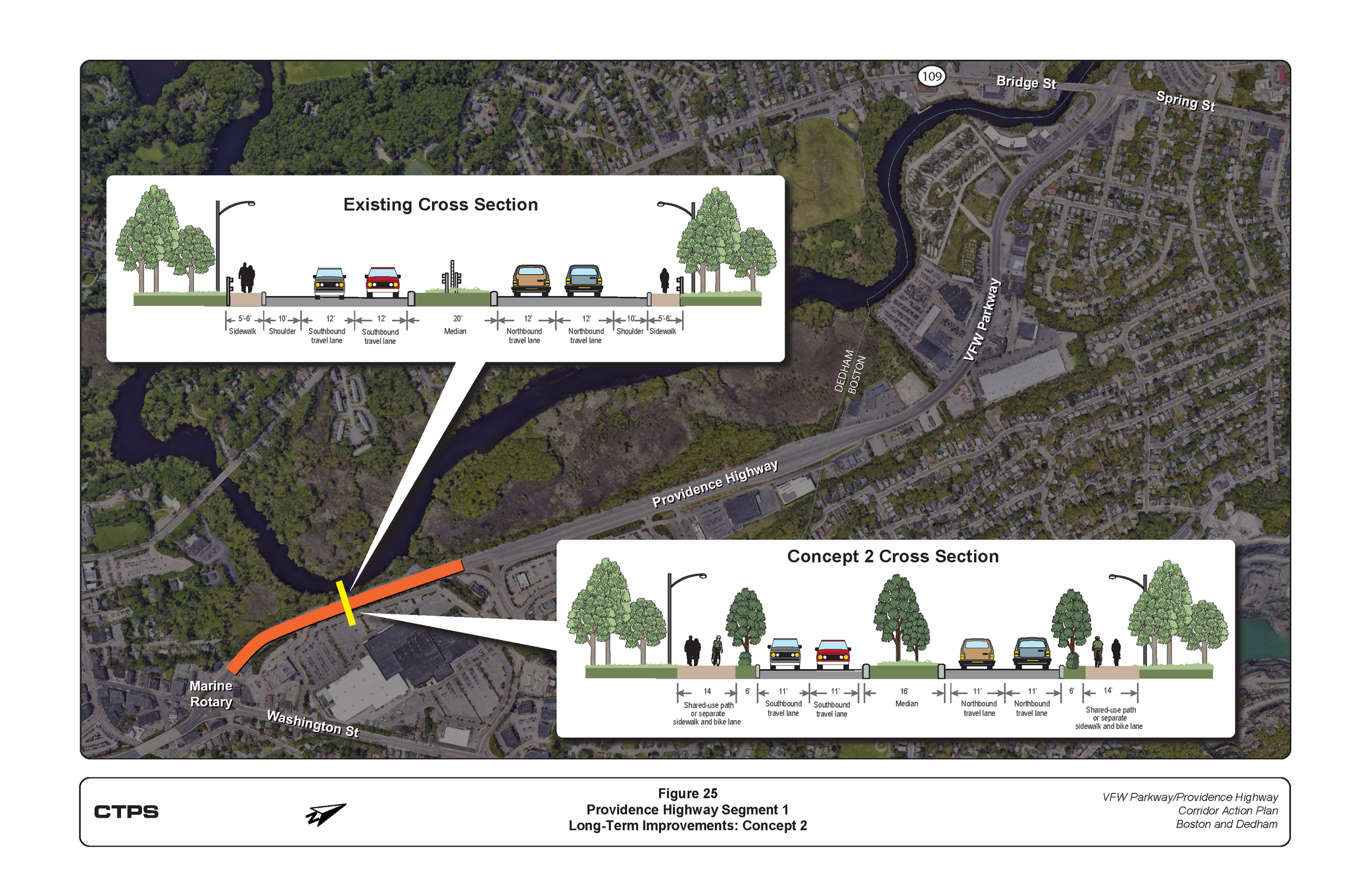
Providence Highway Segment 1
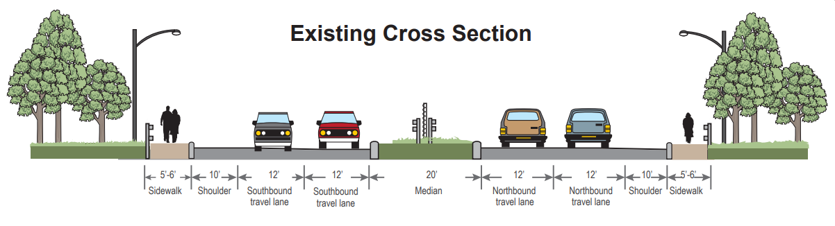
CTPS envisions two potential long-term concepts for the first segment of Providence Highway, which stretches from the Marine Rotary to the Dedham Mall Driveway. Below, you can see cross sections of the roadway for both concepts. Both concepts are similar, however Concept 2 (on the right) includes a tree buffer in place of a shoulder that further narrows the roadway to calm traffic. Use the slider below to compare the the cross sections of these concepts to each other and to the existing cross section above.
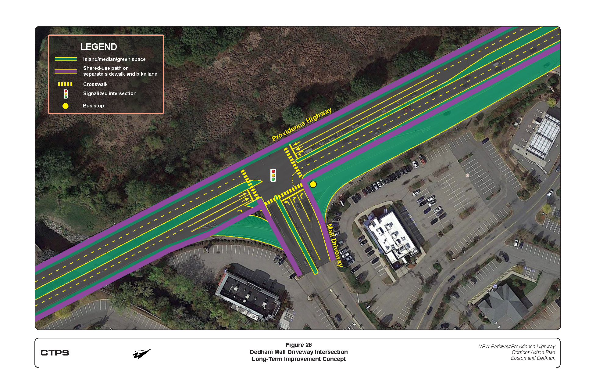
Dedham Mall Driveway Intersection
CTPS developed the below concept for the Dedham Mall Driveway intersection. In this concept, the mall access and U-turn road are eliminated as they make it difficult and unsafe for people walking or biking to cross Providence Highway. Access to the Mall would occur directly from Providence Highway. The concept simplifies traffic movements, adds crosswalks, wheelchair ramps, and space to accommodate people walking, biking, or using mobility devices. Click the image below to enlarge.
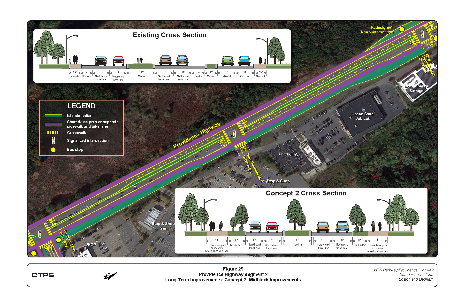
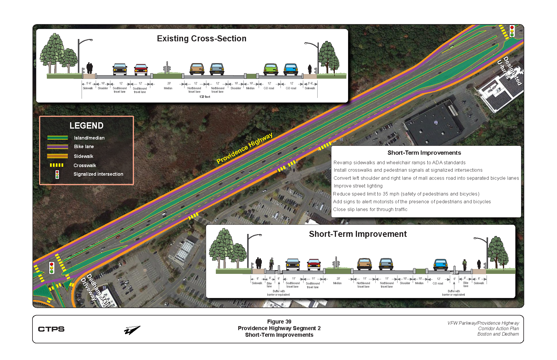
Providence Highway Segment 2
CTPS envisions two potential long-term concepts for the second segment of Providence Highway, which stretches from the Dedham Mall Driveway to the Boston/Dedham border (where VFW Parkway begins). The left image highlights the area of Segment 2. Use the Google Streetview on the right to explore the area as it looks currently.
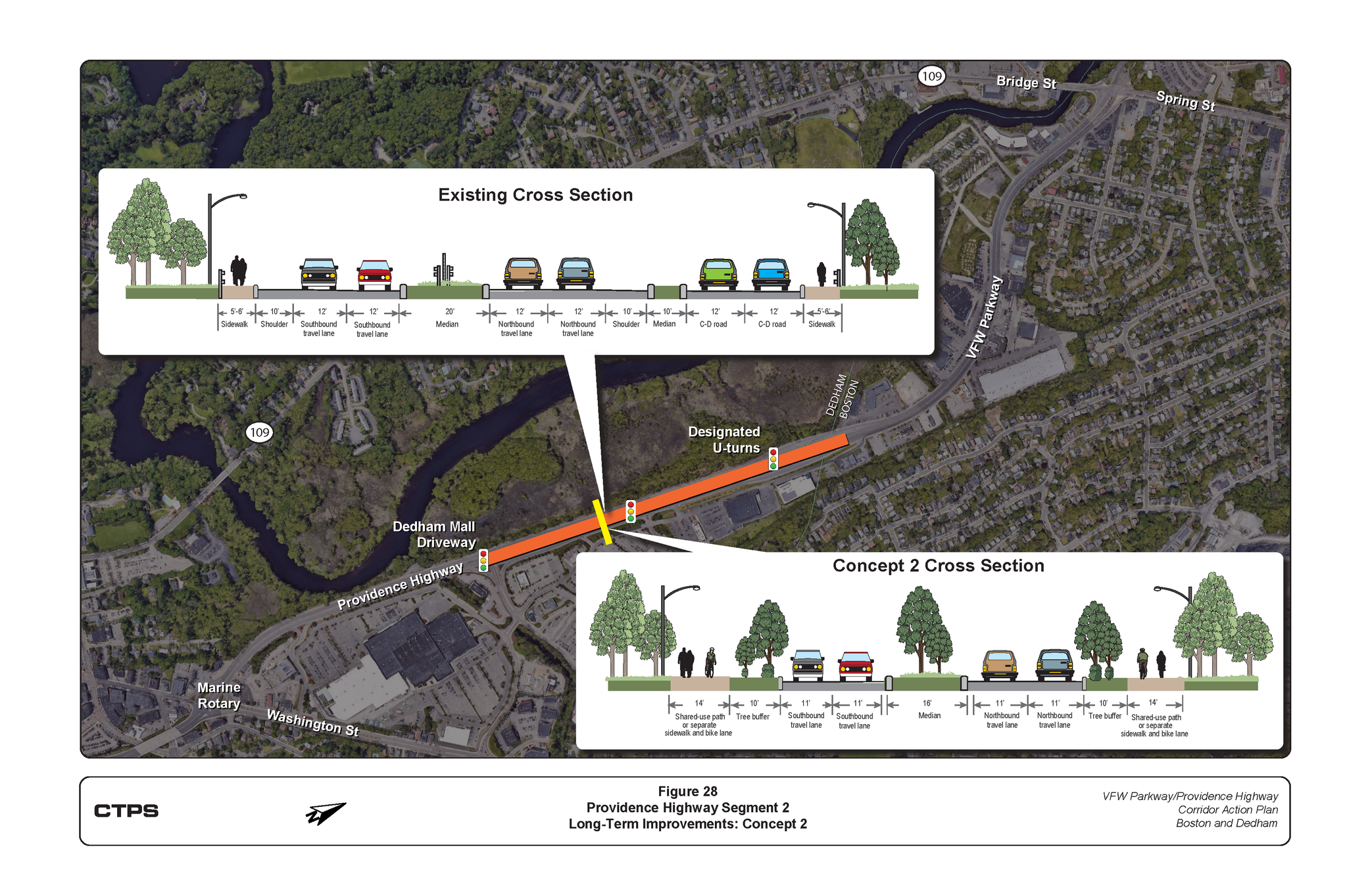
Providence Highway Segment 2
CTPS envisions two potential long-term concepts for the second segment of Providence Highway, which stretches from the Dedham Mall Driveway to the Boston/Dedham border (where VFW Parkway begins). Both concepts are similar, however Concept 2 replaces the shoulder with a tree buffer to calm traffic.
Additional Improvements for Mall Access
Because the mall access and U-turn road are proposed to be eliminated in Concepts 1 and 2, a new signalized intersection midway between the Dedham Mall Driveway and the U-turn intersection is proposed to further enhance access to and from the Dedham Mall, provide more crossing opportunities for people walking or biking, calm traffic, and reduce speeds. Click on the image below to enlarge.
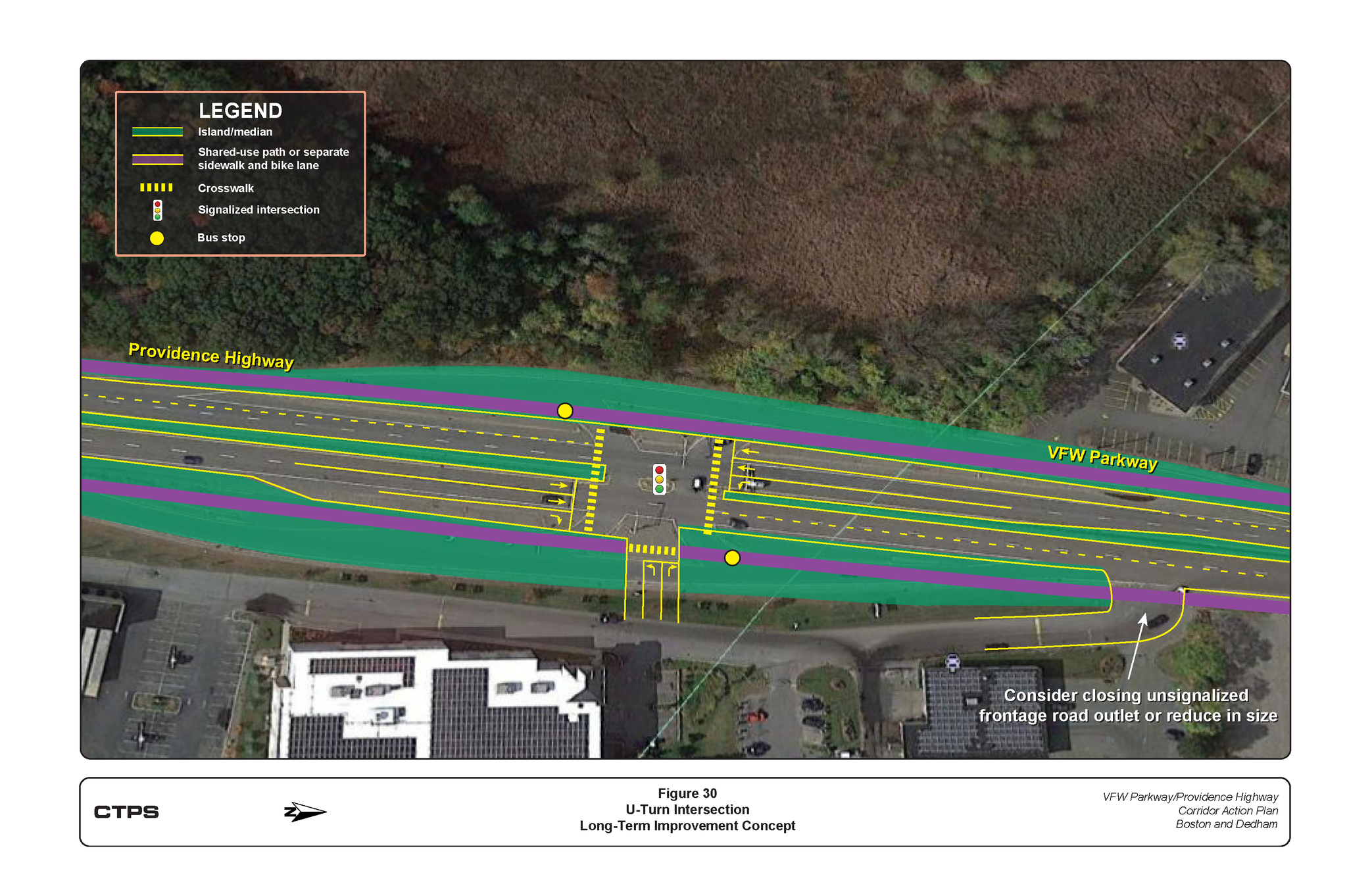
U-Turn Intersection
CTPS proposes a a signalized T-intersection where the existing U-Turn area is. The new layout simplifies traffic movements at the intersection, adds crosswalks, wheelchair ramps, space to accommodate people walking or biking. It includes other upgrades like accessible pedestrian signals, detection for bicycles, and bus stops for Route 52 bus service. Lastly, it provides a connection to the Mall’s internal road system. Click on the image to enlarge.
VFW Parkway
CTPS proposes a concept for the VFW Parkway that consists of two travel lanes, walking and biking facilities, and a tree buffer in each direction. Openings at two locations, A Street and near the McDonald’s restaurant, are proposed to be controlled by traffic signals. This would allow turn maneuvers at the new A Street intersection and a new midblock crossing, providing additional opportunities for people walking or biking to cross VFW Parkway. The concept also proposes adding three bus stop locations for the Route 52 bus.
Short-Term Improvements
Short-term improvements, which typically require less complex design and engineering efforts and often less funding resources, were developed to transform the corridor to address current needs. The time frame categorized as short-term is typically less than five years.
The goals of implementing these short-term improvements are to modify the existing roadway features to improve safety for people walking, biking, riding the bus, or using assistive mobile devices; connect people to places; provide safe access to schools, recreational areas, neighborhoods, and transit stops; and
to support economic vitality.
Note: these concepts are proposals. they are not guaranteed to be implemented
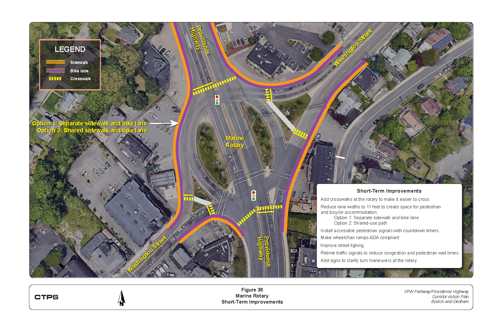
Marine Rotary
Short term improvements for Marine Rotary include adding more crosswalks, shortening crosswalk distances, reducing lane widths and adding spaces for walking and biking, installing accessible pedestrian signals and countdown timers, adding bike infrastructure (detection, boxes, signals, and signage), retiming traffic signals, improving signage in the area. Click the image to enlarge.
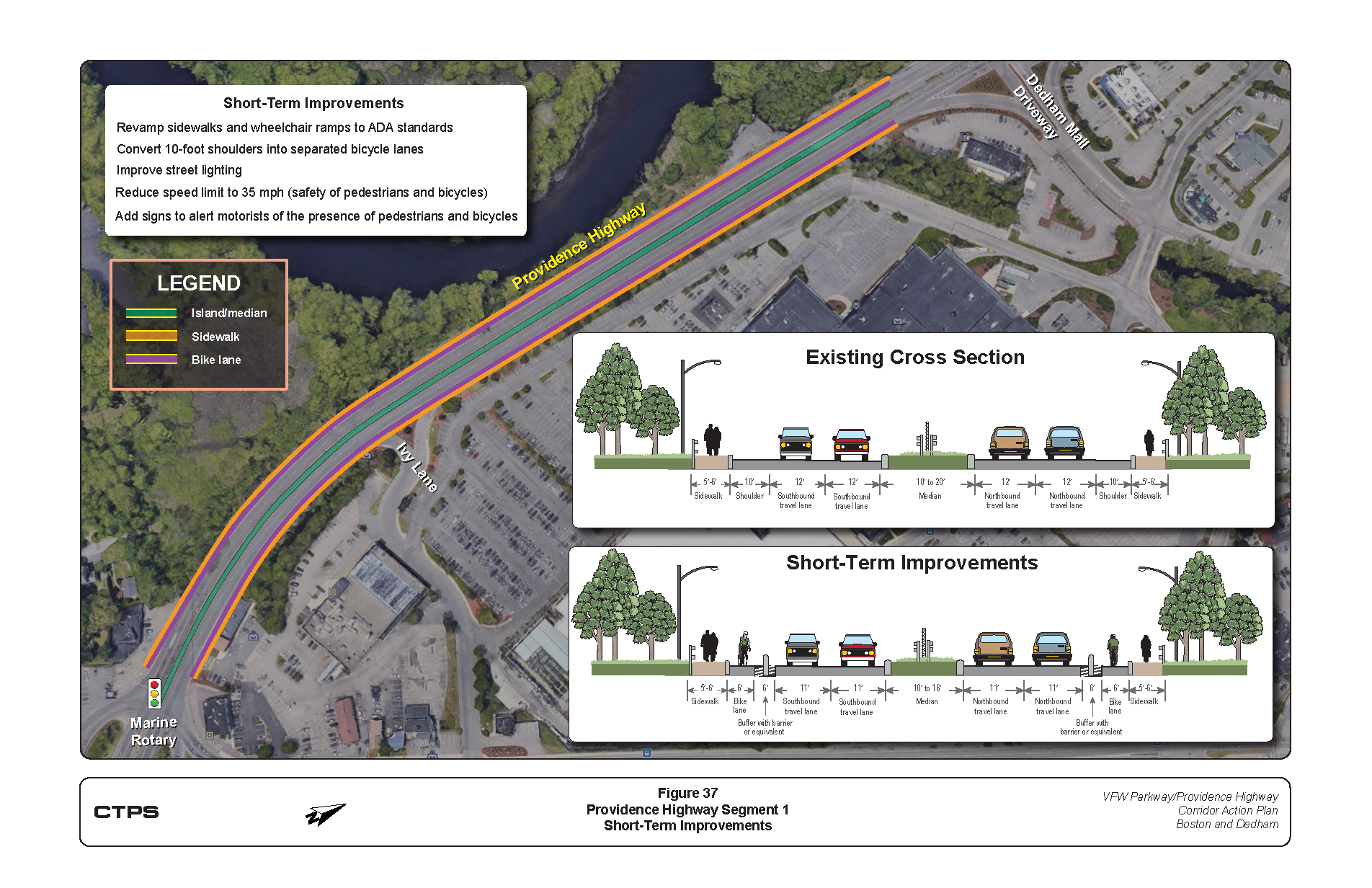
Providence Highway Segment 1
Short term improvements to the first segment of Providence Highway include upgrading sidewalks and curb ramps, narrowing travel lane width, converting shoulders in either direction to separated bike lanes, adding new signage, and improving street lighting at intersections and other crossings. Click on the image to enlarge.
Providence Highway Segment 2
Short term improvements to the second segment of Providence Highway include upgrading sidewalks and curb ramps, narrowing travel lane widths, converting the shoulder on the west side of the road way and the right lane of the mall access road in to separated bike lanes, and adding crosswalks at the signalized intersections. Click on the image to enlarge.
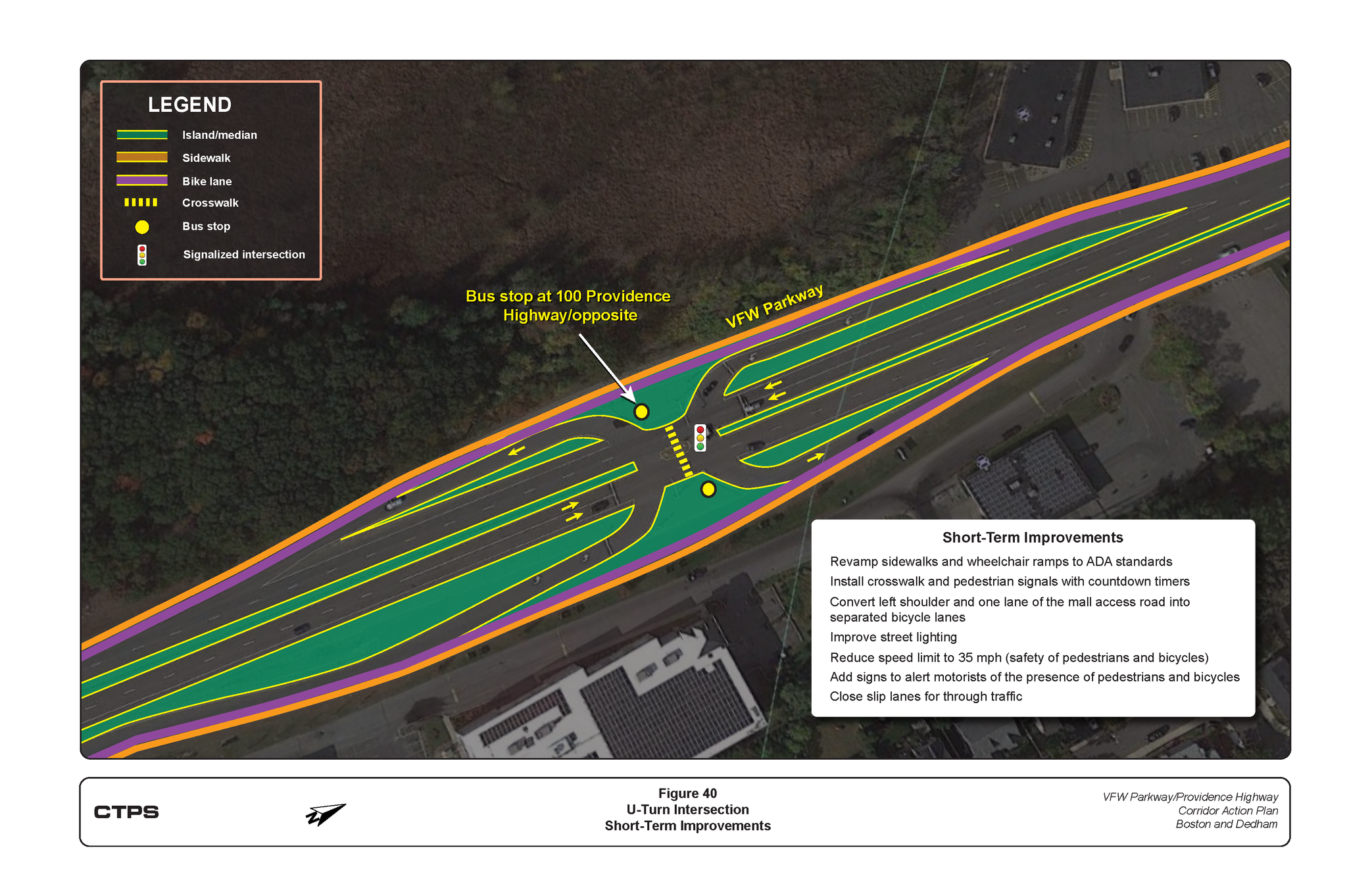
U-Turn Intersection
Short term improvements to the existing U-turn intersection include upgrading sidewalks, narrowing travel lane widths, adding crosswalk with pedestrian signals, extending bike lanes through the intersection, installing bike infrastructure (detection, boxes, signals, and signs), closing the slip lanes for through traffic, and adding new signage. Click on the image to enlarge.
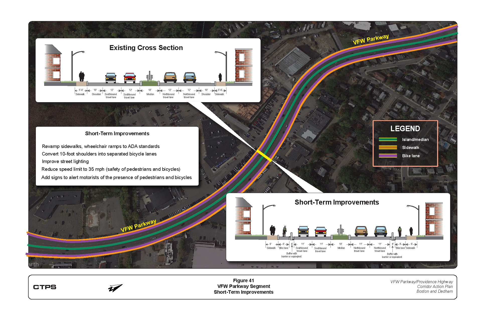
VFW Parkway
Short term improvements to the VFW Parkway segment are similar to those proposed for the Providence Highway segments. They include updating sidewalks and curb ramps, reducing travel lane widths, converting shoulders into separated bike lanes with physical barriers, improving street lighting, adding bus stops, and adding more/new signage. Click on the image to enlarge.
What's Next?
The Corridor Action Plan is the first step in the process of making the VFW Parkway - Providence Highway Corridor safe for people to walk and bike to shops, schools, transit stations, and recreational areas, while supporting existing and future development. Implementing these improvements and developing projects will require cooperation between numerous entities, including MassDOT, MBTA, Town of Dedham, and the City of Boston.
Funding opportunities for this work include:
- Federal-Aid Highway Program, including the FAST Act
- Chapter 90
- MassWorks Infrastructure Program
- Public-Private Partnerships
Additionally, these improvements may be able to be funded using American Rescue Plan Act funding and/or funding distributed as a result of the recently passed federal infrastructure bill.
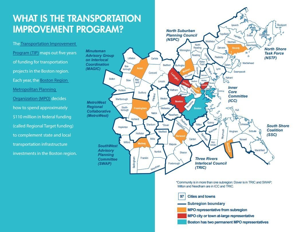
The project will need to be included in the MPO's Transportation Improvement Program (TIP). Read more by clicking the image to the right.
Thank You!
We are excited to share this plan with you and thankful for the time and effort you contributed to its development. If you have any questions, please contact any of the staff listed below.
Jeremy Rosenberger, jrosenberger@dedham-ma.gov
Dedham Planning Director
(781) 751-9241
Travis Pollack, tpollack@mapc.org
Senior Transportation Planner, MAPC
(617) 933-0793
Mark S. Abbott, PE, mabbot@ctps.org
Manager, Traffic Analysis and Design Group, CTPS
(857) 702-3641
VFW Parkway - Providence Highway Corridor Action Plan
By brandtchw