Volunteered Geographic Information
for Citizen Science
![](https://s3.amazonaws.com/media-p.slid.es/uploads/278564/images/2228199/Screenshot_2016-02-11_22.19.03.png)
![](https://s3.amazonaws.com/media-p.slid.es/uploads/278564/images/4313973/globe.png)
Outline
- Geospatial Technology
- Citizen Science
- Disaster and Data Needs
- Demystifying UAV Workflow
- Social Implications
- Conclusions and future work
![](https://s3.amazonaws.com/media-p.slid.es/uploads/278564/images/2073852/DJI.png)
Maps = Power
![](https://upload.wikimedia.org/wikipedia/commons/thumb/c/c0/Waldseemuller_map_2.jpg/1200px-Waldseemuller_map_2.jpg)
Waldseemüller map 1507
Dashboards = Power
Geospatial Technology
Global Positioning System (GPS)
SURVEYING
Remote SEnsing
Geographic Information SYSTEMs (GIS)
Title Text
![](https://s3.amazonaws.com/media-p.slid.es/uploads/278564/images/4263395/GIS.jpg)
GIS and spatial media
(Ricker, 2017)
![](https://s3.amazonaws.com/media-p.slid.es/uploads/278564/images/2226506/tradGIS.png)
Knowledge Politics
Political Power
"...knowledge politics to be shaped by deeply institutionalized tendencies in planning and policy making to grant greater weight to knowledge expressed as quantitative data or represented in cartographic forms."
Data Driven Decision Making
(Elwood & Leszczynski, 2012: 545)
Geoweb
-
interconnected tools and spatial data available on the web spanning multiple geographic regions (Lake and Farley, 2007)
-
Revolutionized spatial data (Sui, 2008)
-
but not democratizing it (Haklay, 2013)
-
Provides access to satellite and aerial imagery! (Goodchild, 2007; Harvey, 2014; Kingsbury & Jones, 2009)
-
Opportunity to contribute Volunteered Geographic Information (Goodchild, 2007)
Maps --> Media
![](https://s3.amazonaws.com/media-p.slid.es/uploads/278564/images/2226878/arrow.png)
Applied
Quantitative
Theory
Qualitative
![](https://s3.amazonaws.com/media-p.slid.es/uploads/278564/images/2226889/selfie.png)
![](https://s3.amazonaws.com/media-p.slid.es/uploads/278564/images/2226896/cart.png)
Spatial Media
Elwood & Leszczynski (2012) New spatial media, new knowledge politics. Transactions of the Institute of British Geographers (38): 544-559.
"Mediums or channels that extend our ability to interact with and create geographic information online" p 544
"From expert to everyday"
(Elwood & Leszczynski, 2012)
![](https://s3.amazonaws.com/media-p.slid.es/uploads/278564/images/3983155/pasted-from-clipboard.png)
![](https://s3.amazonaws.com/media-p.slid.es/uploads/278564/images/3983156/pasted-from-clipboard.png)
Public Participatory Geographic Information Systems (PPGIS)
![](https://s3.amazonaws.com/media-p.slid.es/uploads/278564/images/1832337/mapping2.jpg)
![](https://s3.amazonaws.com/media-p.slid.es/uploads/278564/images/1832513/mapping.jpg)
![](https://s3.amazonaws.com/media-p.slid.es/uploads/278564/images/1832289/vpuu.jpg)
![](https://s3.amazonaws.com/media-p.slid.es/uploads/278564/images/2226630/dataentry.jpg)
![](https://s3.amazonaws.com/media-p.slid.es/uploads/278564/images/1832531/toilet1.jpg)
![](https://s3.amazonaws.com/media-p.slid.es/uploads/278564/images/2228306/landTenure_CapeTown.jpg)
![](https://s3.amazonaws.com/media-p.slid.es/uploads/278564/images/2226506/tradGIS.png)
Geoweb
Spatial Media
Maintain a keen awareness as to not reproduce inequalities. Active engagement in effort to use these technologies to combat inequalities (Elwood, 2015)
{
}
Participatory Mapping
means to illuminate social and environmental injustices
co-construction of knowledge= Better understanding of HAZARDS?
promotion of self and critical awareness that leads to individual, collective social change
Participatory Action Research
"moment of translation
transforming experiential, testimonial and qualitative forms of knowledge into quantitative aggregated or abstracted forms" (Elwood & Leszczynski , 2012: 548)
Photovoice
Purpose
Method by which participants identify, represent, and enhance their community through a specific photographic technique
- Identify community assets and deficits
- Use photography to draw attention to a social issue
- Induce change by informing policy makers
![](https://s3.amazonaws.com/media-p.slid.es/uploads/278564/images/2226408/bornIntoBroth.jpg)
![](https://s3.amazonaws.com/media-p.slid.es/uploads/278564/images/2226409/bornInto2.jpg)
Tell me, I forget.
Show me, I remember.
Involve me, I understand.
-Chinese Proverb (Paulos et al., 2009)
![](https://s3.amazonaws.com/media-p.slid.es/uploads/278564/images/4398374/citizenScience.png)
Citizen Science “scientific work undertaken by members of the general public, often in collaboration with or under the direction of professional scientists and scientific institutions.” (Haklay, 2015)
Examples of Student Work: Capstone Project
![](https://s3.amazonaws.com/media-p.slid.es/uploads/278564/images/3047839/pasted-from-clipboard.png)
![](https://s3.amazonaws.com/media-p.slid.es/uploads/278564/images/4398385/pasted-from-clipboard.png)
Scientists: Julie Masura and Cheryl Greengrove
Students: Chris Vandenburg, Dana Scott
•UW, NOAA, Center for Urban Waters, Sound Experience
MICROPLASTICS
Quantifying microplastics
![](http://media2.intoday.in/indiatoday/images/stories//2017May/greenpeace-microbeads_060817065344.jpg)
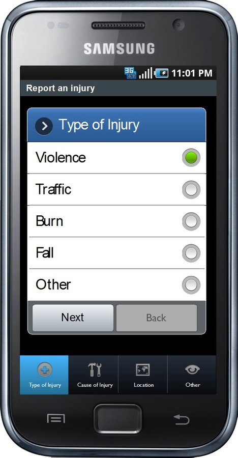
Data Entry For Citizen Science?
Who is the end user?
Who is entering the data?
What is going to be done with data?
Cost?
Technical knowhow of the developer?
Microplastics
![](https://s3.amazonaws.com/media-p.slid.es/uploads/278564/images/4398370/UWBOAT.jpg)
![](https://s3.amazonaws.com/media-p.slid.es/uploads/278564/images/4398386/pasted-from-clipboard.png)
![](https://s3.amazonaws.com/media-p.slid.es/uploads/278564/images/4398387/pasted-from-clipboard.png)
![](https://s3.amazonaws.com/media-p.slid.es/uploads/278564/images/4399475/pasted-from-clipboard.png)
Julie's website http://depts.washington.edu/uwtocelb/wordpress/
![](https://s3.amazonaws.com/media-p.slid.es/uploads/278564/images/4399468/pasted-from-clipboard.png)
ShowerHead Microbiome
Many Voices
Many forms
![](https://s3.amazonaws.com/media-p.slid.es/uploads/278564/images/2226457/PM.png)
Medium influences who will participate
(Chambers 2006)
Disaster Cycle
![](https://s3.amazonaws.com/media-p.slid.es/uploads/278564/images/3983121/pasted-from-clipboard.png)
DIFFERENT Data NeEDS AT EACH PHASE
![](https://s3.amazonaws.com/media-p.slid.es/uploads/278564/images/3983139/pasted-from-clipboard.png)
![](https://s3.amazonaws.com/media-p.slid.es/uploads/278564/images/3983126/pasted-from-clipboard.png)
DATA PREPAREDNESS
AS
DISASTER PREPAREDNESS
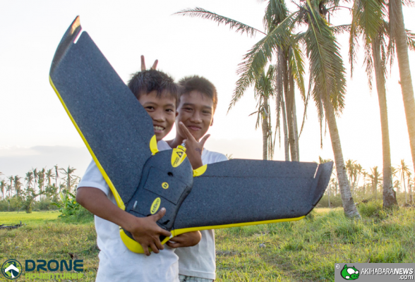
Unmanned Aerial Vehicle (UAV)
![](https://s3.amazonaws.com/media-p.slid.es/uploads/278564/images/2073852/DJI.png)
![](https://s3.amazonaws.com/media-p.slid.es/uploads/278564/images/2227458/Picture1.jpg)
Aerial Photography
![](https://s3.amazonaws.com/media-p.slid.es/uploads/278564/images/2227599/ruston.png)
![](https://s3.amazonaws.com/media-p.slid.es/uploads/278564/images/2227190/tacoma2.jpg)
![](https://s3.amazonaws.com/media-p.slid.es/uploads/278564/images/2074320/nadar.jpg)
Negative connotation
Militarization
Surveillance
(Sandvik & Lohne, 2014)
![](https://s3.amazonaws.com/media-p.slid.es/uploads/278564/images/2073852/DJI.png)
![](https://s3.amazonaws.com/media-p.slid.es/uploads/278564/images/2227117/dronebroken.png)
Drones for good
- Archaeology
- Forestry
- Emergency response
- Search and Rescue
- Natural resource management
- (Precision)Agriculture
- Construction
- Remote Sensing
- (Colomina & Molina, 2014; Everaerts, 2008, Forance et al., 2014; Upton et al., 2015; Zhang & Kovacs, 2012; Rokhmana, 2015).
![](https://s3.amazonaws.com/media-p.slid.es/uploads/278564/images/2227130/pix4d.png)
Organized #DronesforGood
- Digital Humanitarianism
- OpenAerialMap
- UAViators
- DIYDrones
- OpenDroneMap
- DroneAdventures
- Conservation Drones
- Drone Code
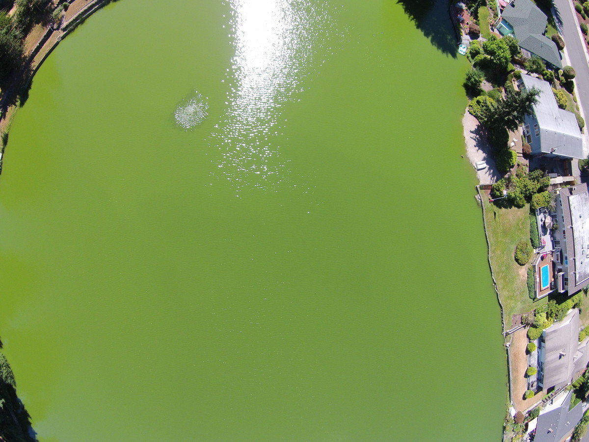
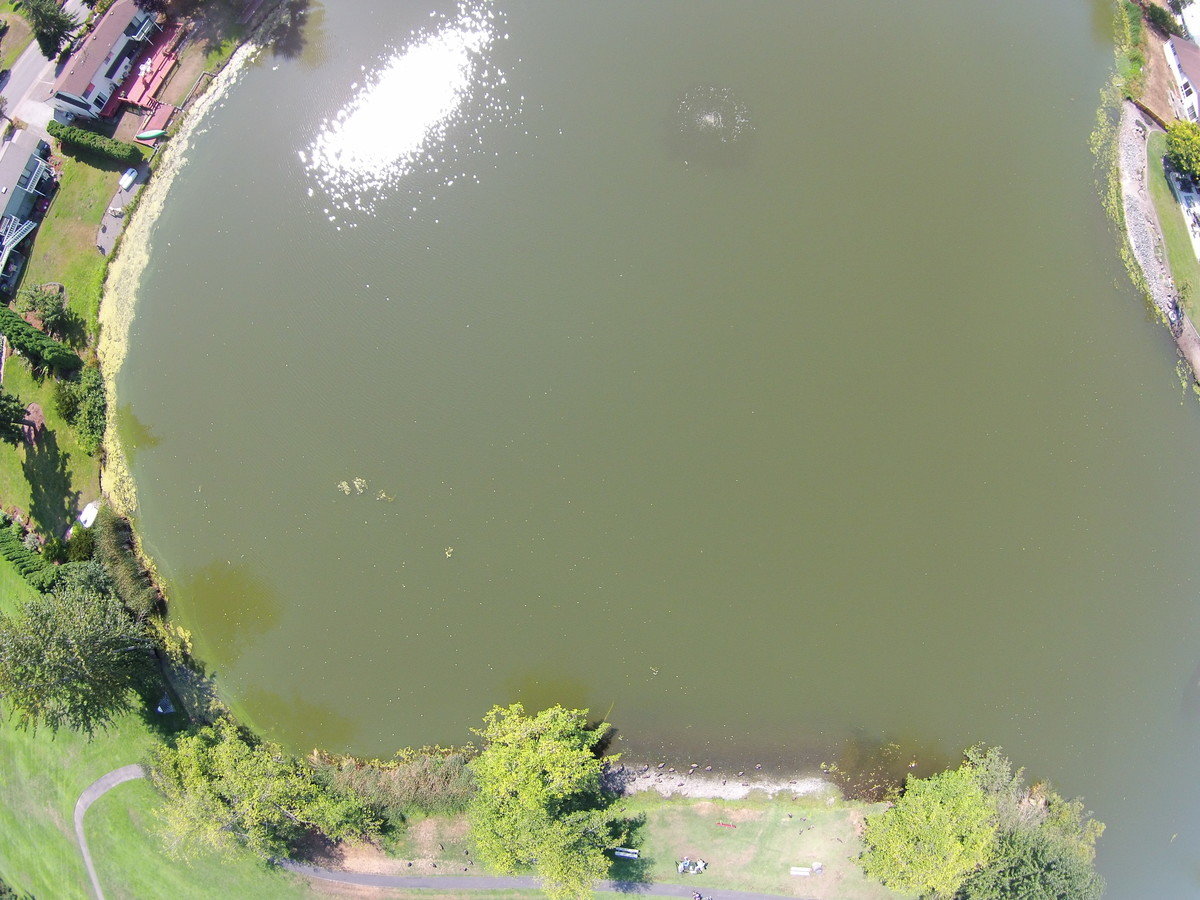
Taiwan’s National Cheng Kung University created this 3D model from aerial imagery captured by UAV.
The Appalachian Mountaintop Patrol (AMP)
Laura grace chipley
Aerial Photovoice
- evokes emotion
- representations of place
- What if we used it for something more important?
Digital Maps! Digital Globes offer basemaps for participatory mapping. But they also control temporal and spatial resolution of those basemaps
![](https://s3.amazonaws.com/media-p.slid.es/uploads/278564/images/1832264/Picture3.jpg)
![](https://s3.amazonaws.com/media-p.slid.es/uploads/278564/images/2226630/dataentry.jpg)
Putting a UAV in the hands of a community, could they monitor...
- Community changes through the course of a day, season, year...
- Acute changes - landslide event, urban encroachment
- Gradual changes - land use change, urban growth
- Ecosystem services
- Access to water resources, refugee camp movement
- Habitat loss...
- ?????
Particulate flow
![](https://s3.amazonaws.com/media-p.slid.es/uploads/278564/images/4398353/Woodmont_Creek_Current_v1.jpg)
![](https://s3.amazonaws.com/media-p.slid.es/uploads/278564/images/3983161/pasted-from-clipboard.png)
Demystify the Workflow
Steps
- Drone Selection Process
- Flight Practice and Planning
- Flying
- Data Processing
![](https://s3.amazonaws.com/media-p.slid.es/uploads/278564/images/2227212/faa.png)
Drone Selection
(Eisenbeiss, 2011: 34)
![](https://s3.amazonaws.com/media-p.slid.es/uploads/278564/images/2227591/selectionguide.png)
Classified by takeoff and landing methods
![](https://s3.amazonaws.com/media-p.slid.es/uploads/278564/images/2229526/ebee.jpg)
![](https://s3.amazonaws.com/media-p.slid.es/uploads/278564/images/2229532/rotor2.jpg)
DJI Phantom 2 Vision Plus
- 25 minute flight time
- Return home when battery is low
- Compass and GPS
- 14 mega pixel camera and Gimble
- ~$1200
![](https://s3.amazonaws.com/media-p.slid.es/uploads/278564/images/2073852/DJI.png)
![](https://s3.amazonaws.com/media-p.slid.es/uploads/278564/images/2227482/processPix4d.png)
Process
Flight Practice and Planning
![](https://s3.amazonaws.com/media-p.slid.es/uploads/278564/images/2227597/oops.png)
Flying
Auto Pilot
Free Flight
![](https://s3.amazonaws.com/media-p.slid.es/uploads/278564/images/2227180/chris.jpg)
![](https://s3.amazonaws.com/media-p.slid.es/uploads/278564/images/2227543/dronedeployAutoPilot.jpeg)
Image Processing
Photography and Cinematography
Mapping
![](https://s3.amazonaws.com/media-p.slid.es/uploads/278564/images/2227228/photovideoedit.png)
![](https://s3.amazonaws.com/media-p.slid.es/uploads/278564/images/2227491/rustonagi.png)
Structure from Motion (SfM) software
![](https://s3.amazonaws.com/media-p.slid.es/uploads/278564/images/2227243/pix4dray.png)
Generate an Othophoto
![](https://s3.amazonaws.com/media-p.slid.es/uploads/278564/images/2227485/desmoine.jpg)
2012
2015
Title Text
- Bullet One
- Bullet Two
- Bullet Three
![](https://s3.amazonaws.com/media-p.slid.es/uploads/278564/images/2227249/ray.png)
77 photos to make an orthophoto, 3D model + more in
> one hour total
![](https://s3.amazonaws.com/media-p.slid.es/uploads/278564/images/3983437/Screenshot_2017-07-13_10.09.24.png)
![](https://s3.amazonaws.com/media-p.slid.es/uploads/278564/images/2227856/20150730_144950.jpg)
![](https://s3.amazonaws.com/media-p.slid.es/uploads/278564/images/2073852/DJI.png)
Share your data
![](https://s3.amazonaws.com/media-p.slid.es/uploads/278564/images/3983127/pasted-from-clipboard.png)
![](https://s3.amazonaws.com/media-p.slid.es/uploads/278564/images/3983128/pasted-from-clipboard.png)
![](https://s3.amazonaws.com/media-p.slid.es/uploads/278564/images/3983165/pasted-from-clipboard.png)
Social
Implications
![](https://s3.amazonaws.com/media-p.slid.es/uploads/278564/images/2227599/ruston.png)
Similar critiques of GIS
and mobile spatial media (Elwood, 2008; Thatcher, 2016)
Privacy (Curry, 1997)
- Geoweb transformation of the social contract around privacy – societal agreement (Elwood, 2015)
Access to technology (Obermeyer, 1995)
Risk of Re-enforcing inequality
Legality
- Decline of the public sector - private sector leading
- "Enthusiasts" can fly, not governments
- International regulations vary dramatically
![](https://s3.amazonaws.com/media-p.slid.es/uploads/278564/images/2229577/dutchHawkDrone.jpg)
![](https://s3.amazonaws.com/media-p.slid.es/uploads/278564/images/2229586/phillip.png)
Medium influences who will participate
(Chambers, 2006)
![](https://s3.amazonaws.com/media-p.slid.es/uploads/278564/images/2073852/DJI.png)
Tacoma Professional
Tacoma Amateur
Only scratching the surface
MapTime
OSM for disaster PREPAREDNESS
![](https://s3.amazonaws.com/media-p.slid.es/uploads/278564/images/4313453/firechiefMapTime.jpg)
Student Project: Pull from OSM
Streets:
•*Cobblestone streets
•*Roundabouts at intersections
•*One-way streets
•Narrow two-way streets (because of street parking, only one vehicle at a time can pass through in either direction.)
•Speed bumps on streets
Residences:
•*Single-family home; Duplex, Triplex, or Apartment Building
•Year built
•*Number of floors
• *how many apartments
•*Location of Gas Meter(s)
•*Location of Electric Meter(s)
•*Location of Stationary Propane Tank(s)
•*Location of Stationary Heating Fuel Tank (Heating Oil)
•Solar Panels of Roof? (Y or N)
•*Presence of a detached garage
Mobile application
for disaster preparedness
![](https://s3.amazonaws.com/media-p.slid.es/uploads/278564/images/4313454/Screenshot_2017-11-09_13.12.14.png)
Communities of Practice
![](https://s3.amazonaws.com/media-p.slid.es/uploads/278564/images/4313465/station1.png)
![](https://s3.amazonaws.com/media-p.slid.es/uploads/278564/images/4313466/poster.png)
Esri App Studio
![](https://s3.amazonaws.com/media-p.slid.es/uploads/278564/images/4313464/appDev.png)
Communities of interest
![](https://s3.amazonaws.com/media-p.slid.es/uploads/278564/images/4313470/home.png)
Data
Ambiently collected?
Actively collected?
More research questions!
What knowledge is transferred
through the data entry/collection process?
Through the map interaction process?
Conclusion & Future
Maps are political
INVITE PARTICIPATION
Work with communities
Opportunity to establish ethical standards for UAV usage
![](https://s3.amazonaws.com/media-p.slid.es/uploads/278564/images/2226718/Picture1.jpg)
DATA PREPAREDNESS AS DISASTER PREPAREDNESS
- Illuminate social and environmental injustice
- Relevant Temporal Resolution
- Enhanced Spatial Resolution
- Increased coverage
- Complement existing research methods
- Opportunity to establish good practice with community engagement
![](https://s3.amazonaws.com/media-p.slid.es/uploads/278564/images/3983461/pasted-from-clipboard.png)
![](https://s3.amazonaws.com/media-p.slid.es/uploads/278564/images/2226503/Fig1_Ready.png)
Participation sparks critical thinking during each step of the process
![](https://s3.amazonaws.com/media-p.slid.es/uploads/278564/images/3983169/pasted-from-clipboard.png)
![](https://s3.amazonaws.com/media-p.slid.es/uploads/278564/images/3983170/pasted-from-clipboard.png)
Data Day Dreams
![](https://s3.amazonaws.com/media-p.slid.es/uploads/278564/images/3983175/pasted-from-clipboard.png)
Challenge
Participate in Citizen Science!
Knowledge Discovery!
![](https://s3.amazonaws.com/media-p.slid.es/uploads/278564/images/2074377/capetown.png)
![](https://s3.amazonaws.com/media-p.slid.es/uploads/278564/images/2226630/dataentry.jpg)
![](https://s3.amazonaws.com/media-p.slid.es/uploads/278564/images/2073852/DJI.png)
![](https://s3.amazonaws.com/media-p.slid.es/uploads/278564/images/3983169/pasted-from-clipboard.png)
Thank You.
Acknowledgments: Muki Haklay, Agnieszka Leszczynski,
Julie Masura, Andrew James, Sarah Elwood, Highline College Mast Center
University of Washington Office of Global Affairs Strategic International Partnership Travel Award
![](https://s3.amazonaws.com/media-p.slid.es/uploads/278564/images/3983166/pasted-from-clipboard.png)
![](https://s3.amazonaws.com/media-p.slid.es/uploads/278564/images/4313460/TFD.png)
![](https://s3.amazonaws.com/media-p.slid.es/uploads/278564/images/4313524/UCL.png)
![](https://s3.amazonaws.com/media-p.slid.es/uploads/278564/images/4313957/cyberGIS.png)
MasTCenter
By Britta Ricker
MasTCenter
- 1,297