Maps in JavaScript

js.arcgis.com
esri/Map Class
contains properties and methods for storing, managing, and overlaying layers common to both 2D and 3D viewing.
A single map may be referenced by multiple views
Views
A MapView displays a 2D view of a Map instance. An instance of MapView must be created to render a Map in 2D.
A SceneView displays a 3D view of a Map instance.
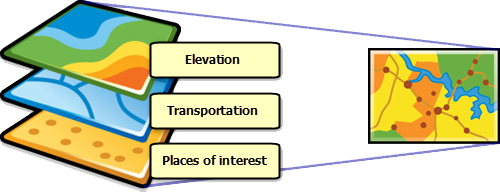
Layers
- the most fundamental component of a Map
- a collection of spatial data in the form of vector graphics or raster images that represent real-world phenomena.
- may contain discrete features that store vector data or continuous cells/pixels that store raster data.
- Multiple layers may be added to the same map and overlaid on top of one another for visualization and analytical purposes
Which to Use?
-
GraphicsLayer (client-side layer)
- Dynamic data from other part (JS or back-end) of application.
- Examples:
- Place a point on the map where the user's registered location is
- Allow the user to click on the map and you want to place a pin at that location
- Demo (associated guide)
Which to Use?
-
FeatureLayer
- Similar in representation to the GraphicsLayer, but data displayed comes from an ArcGIS REST API (FeatureService URL)
- Examples:
- Show building footprints (polygons) of a campus
- Show voting districts and allow visitor to highlight which districts voted in a specific way
- You have a dataset you want to host in ArcGIS Online and then display it (Guide)
- Demo
- Query Demo
- Create a Hosted FeatureService from scratch demo
Which to Use?
-
MapImageLayer
- allows you to display and analyze data from sublayers defined in a map service, exporting images instead of features
- MapImageLayer processing is handled by the server, not the client.
- Examples:
- Displaying reference layers on your map, like crime data from ArcGIS Living Atlas.
- If you find any ArcGIS REST Endpoint online that ends with "/mapserver/" in general you can add that to your map using this layer type.
- Displaying reference layers on your map, like crime data from ArcGIS Living Atlas.
- Demo - Modify rendering of MapImageLayer on the Fly
Can't Choose?
- Build your map in ArcGIS Online, then create that map by ID.
- Demo


Slack: #esri
Bonus: Geolocation
Maps in JavaScript Workshop
By Gavin R
Maps in JavaScript Workshop
A quick workshop to get audience up to speed with creating maps with the ArcGIS API for JavaScript
