Seattle Maptime
Making Maps with Drone (Part 1 ?)
March 6 , 2025
Peter Keum, GISP
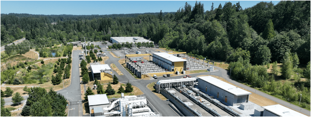
King County Wastewater Treatment
Drone Program Lead/ GIS Analyst
Learning Objectives
- Drone hardware & regulations
- Imagery processing software & workflows.
- Affordable aerial imagery generation.
Understand & Learn
Part 1
- Introduction
- Regulation
- Hardware
- Software
Part 2
- Work flow
- Products
- More....

Text
Text

Text


CUGOS


King County Wastewater Treatment by Numbers
-
2 million residents
-
424 square miles
-
383 miles sewer pipeline (2.5 inch to 14 ft)
-
74 facilities (PS & RS)
-
5 Treatment Plants: 180 MGD ~ Max. 900 MGD

Seattle, WA --> Medford, OR
WTD GIS
Maintain Sewer GIS Data
- FIRS (Facility Information Retrieval System) Data
- Maintenance Hole
- Pipes
- Pump Stations
- Regulator Stations
- Treatment Plants
- Outfalls
- Flow Monitors
- CP Stations
- Connection Points
- Site Plan Data
- 3D Models
- Drone Collected Data
- .... many many more

WTD
GIS
DATA
WTD GIS

WTD
King County
GIS
Data Library
There are 17 county agencies support King County GIS Data Library System
WLRD
Assessor
Road
Many More
+
So Let's Dive In!
Short Back Story

CUGOS April 2014
"Google Guys"

It's just a toy...past examples of what used to be


It's just a toy...


It's just a toy...
It's just a toy...

2016


- Price /Performance
- Easy to use
- Quality data collection
- Adopting Rule by FAA

Why Now?
Cell Phone Technology + Lower $$
- Electronic Control System (ECS)
- Accelerometer & Gyroscope Chip
- GPS Chip
- Lithium Polymer (LiPo) Battery
- Motors


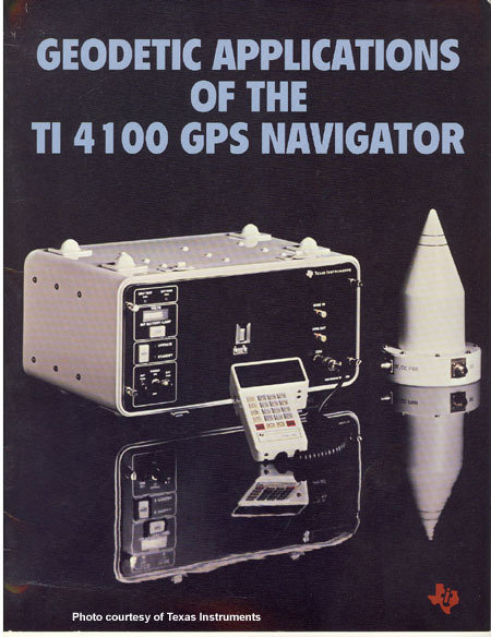
Integrated gyroscopic/GPS Chip in 2000's = $10,000
In 2017 = $3

1981 $120,000
2013
$5 - $15
In 2025 = $3 (??) less than $1
UAV - Unmanned Aerial Vehicle
FAA Definition: Unmanned Aircraft (UA) system that is operated by a pilot via ground control or on-board computer.


What's in the name?
UAV = Unmanned Aerial Vehicle
UAS = Unmanned Aerial System
DRONE = Dynamic Remotely Operated Navigation Equipment
RPAS = Remotely Piloted Aircraft System
UAV Categories

Small - $
- Size: 1 - 2 meters ( 3 ft - 6.5 ft), < 55 lbs.
- Control: Radio control
Medium
- Size: Equivalent to a car, ~ 1000 lbs.
- Control: Visual Line Of Sight (VLOS) & Beyond LOS, RC & Satellite ~ $$$
Large
- Size: > 30,000 lbs.
- Control: Visual Line Of Sight (VLOS) & Beyond LOS, RC & Satellite ~ $$$$


Sensors Payload


Multi-spectral
Thermal Infrared

Lidar Camera

High resolution digital camera (100 MP)

Lidar Camera
Lidar Camera
Methane Gas Dector
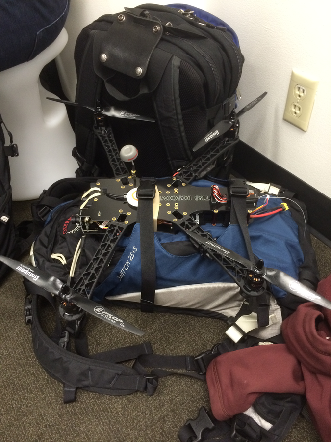
RPAS as Platform
Multi-rotors
Fixed-wing & VTOL

- Shorter flight time (< 45 min)
- Cover smaller area
- Highly maneuverable
- Less expensive
- Access to confined spaces
- Long flight time (+ 40min)
- Covers very large area

(vertical take-off & land)


1. Aircraft + Sensor (Data Collection)
2. Data Processing & Analyzing (GIS)
3. Information Products
||
+

Information Products
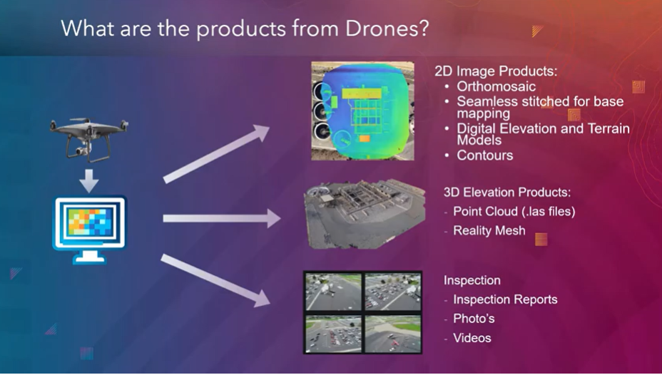
credit: Esri

Drone

GIS
Great Combo?
&
Great combo !
GIS & DRONE


FAA Regulations - Where are we now?

Regulations
-
Fly under 400 feet above ground level
-
Not to fly < 5 nautical miles around airport
-
Aircraft < 55 lbs.
-
Fly during daytime
-
Fly visual line of sight ( VLOS)
-
No flight over non-participating people
FAA Part 107 Rule
Hobby/Recreation
-
Self register (over 13 yrs old)
-
Fly under 400 feet above ground level
-
Not to fly < 5 nautical miles around airport
-
Aircraft < 55 lbs.
-
Fly during daytime
-
Fly visual line of sight ( VLOS)
- Less than 250 grams (0.55 lbs) - No need to register with FAA
- More than 250 grams register with FAA $5.00
-
Be at least 16 yrs old
-
Pass the initial aeronautical knowledge exam
-
Online recurring training every 24 month
-
Understand recreational flying requirements
-
Take TRUST
-
Online recurring training every 24 month
Part 1
- Introduction
- Hardware
- Software
- Regulation
Part 2
- Work flow
- Products
- More....


1. Platform + Sensor (Data Collection)
2. Data Processing & Analyzing (GIS)
3. Information Products


Part 2: Work Flow


1. Platform + Sensor (Data Collection)
2. Data Processing & Analyzing (GIS)
3. Information Products
Part 2: Work Flow

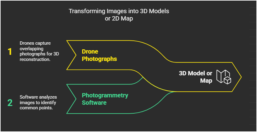
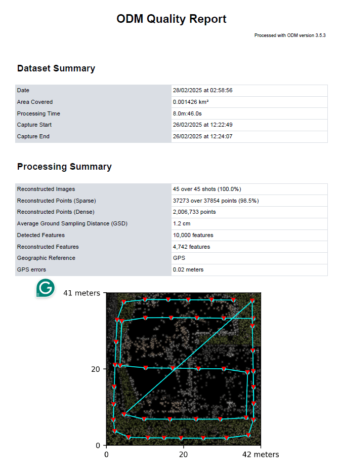
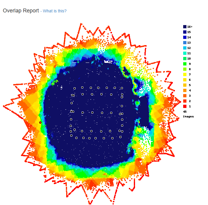
Structure from Motion (SfM)
Part 2: Data Processing
SfM uses overlapping drone photos to reconstruct a 3D model by identifying common points and calculating their position
Photogrammetry = taking measurement from photos
Part 2: Data Processing
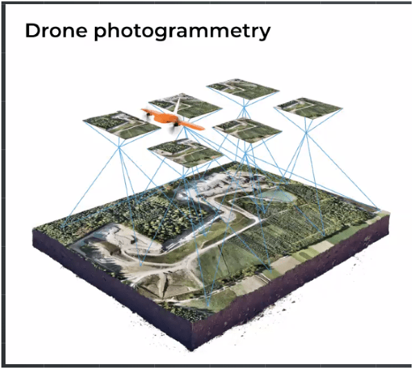
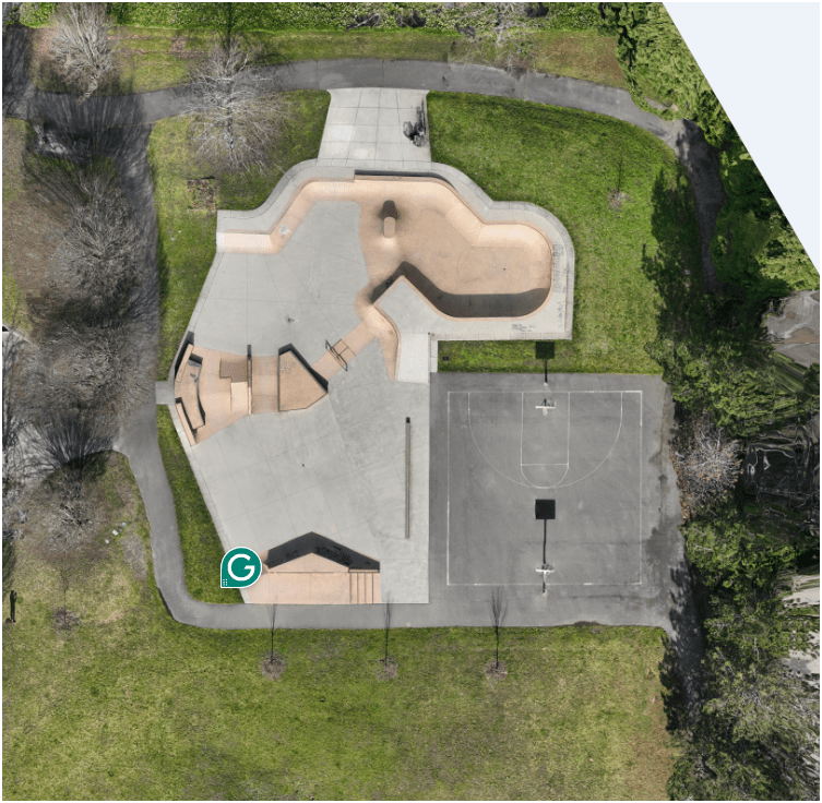
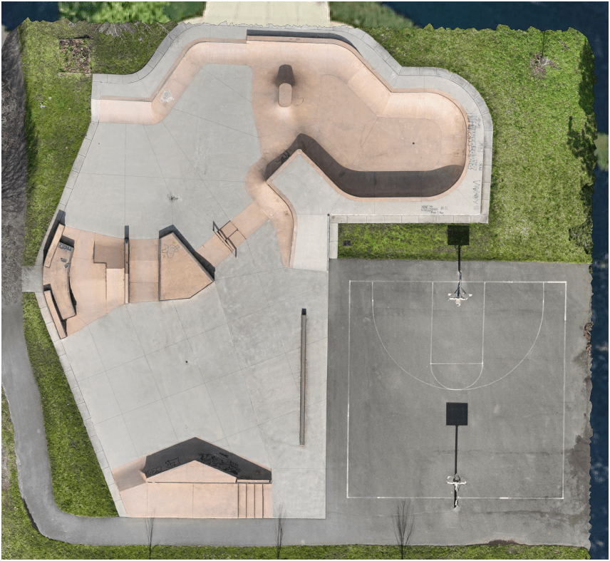
Drone Photogrammetry is the process of using drone-captured images to create accurate 3D models or/and maps of the real world
Drone Photogrammetry

Data Processing

Input Sequences in DD
Ground Control Points


Increase accuracy of drone map

GCP's make your map accurate BUT do not let you know HOW accurate the map is.
Ground Control Points
RTK = Real-Time Kinematic

Workflow Example
Whidbey Island, Langley Downtown example


Step 1. Flight with Data Collection
- Collected 200 Images
- Using Agisoft PhotoScan to stich images
- Alt. Tool - Microsoft Image Composite Editor (ICE)

Step 2. Data Processing
- QGIS to georeference aerial imagery export to tiff file
- Using GDAL
- Or use mbutili to export into tiles
gdal2tiles.py --profile=mercator -z 1-22 yourmap.tif outputfolder
Step 3. Information Product 1
- Create web-map using GitHub's gh-page
git checkout gh-pages
git add outputfolder
git commit -m "Yes... TILE DATA"
git push
Step 3A. Information Product 2
- Using imagery to digitize street, add features to OSM
- Add below url into OpenStreetMap iD Editor
http://langleywa.github.io/gisdata/tiles/langley-2nd-street-2014-tms/{z}/{x}/{y}.png1. Mission Planning
2. Data Processing
3. Information Products
Part 3: Work Flow Guide
- MapsMadeEasy - MapPilot
- Dronelink
- Waypointmap.com
- Copterus.app
- Pix4D
- DroneDeploy
- DJI Fly/Pilot
- Pix4D
- DroneDeploy
- Metashape
- SiteScan
2. Data Processing
Part 3: Work Step Guide
- Pix4D
- DroneDeploy
- Metashape
- SiteScan
WebODM
2. Data Processing
Part 3: Work Step Guide
- Pix4D
- DroneDeploy
- Metashape
- SiteScan
MapsMadeEasy
2. Data Processing
Part 3: Work Step Guide
- Pix4D
- DroneDeploy
- Metashape
- SiteScan
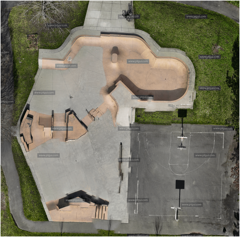
PTGui
MapsMadeEasy
2. Data Processing
Part 3: Work Step Guide
- SiteScan
- DroneDeploy
Demo example
"First do it, then do it right, then do it better."

Credit: Addy Osmani
Saw it from Lyzi Diamond (one of the founder of Maptime)
Doing is Learning, but...

Doing with mistakes?

It's still learning!
A
B
L

C
Tobin Bradley, Mecklenburg County, NC
Tools

(Future Talk)
- Monthly Meeting - Every 3rd Thursday over Zoom
- Share resources online
- Help educate and introduce new users to the field of drone mapping and GIS
CUGOS
Cascadia
Users
of
Geospatial
Open
Source


END
for now
peter.keum@kingcounty.gov
March 6 2025 - Seattle Maptime Presentation - Drone to Map
By Peter Keum
March 6 2025 - Seattle Maptime Presentation - Drone to Map
Seattle Maptime to share how to use low cost drone to generate aerial maps for the hobbyist.


