GIS : Geographic Information System
Part 1: What is it? & Why Use it?
Part 2: How is it being used in WTD?
September 9, 2024
Peter Keum - WTD Senior GIS Specialist

King Street Center, Pioneer Square
WTD GIS Team
- 7 GIS Specialists

Supervisor
Part 1: What is it? & Why Use it?
Part 2: How is it being used in WTD?
GIS : Geographic Information System

GIS : Geographic Information Systems
A System designed to
- Capture
- Store
- Manipulate
- Analyze
- Manage
- Present
GIS : Geographic Information Systems

- People
- Methods (Analysis) - Layer
- Data - Vector & Raster
- Software
- Hardware
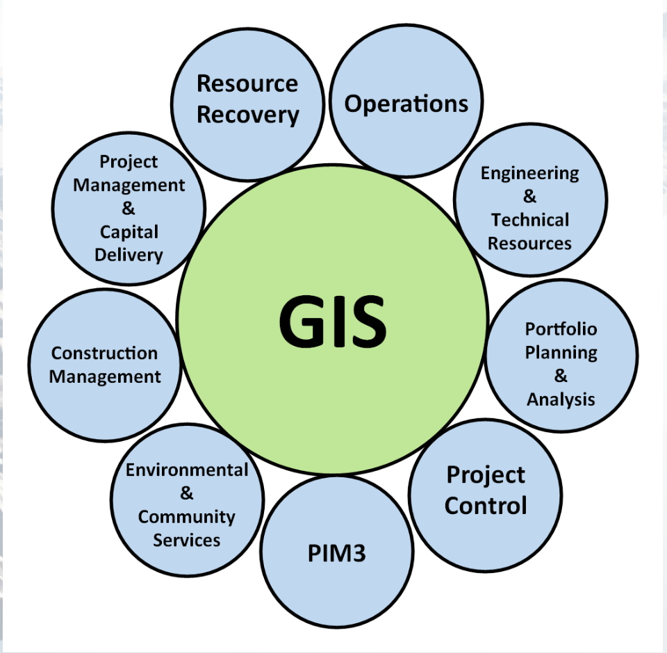
What makes up a GIS?
Geospatial Data
- Where?
- What?
- How?
- When?

Spatial Data = Location Information
"Data Sandwich"


GIS
"Data Sandwich"

Vector Data & Raster Data
Vector Data - discrete entities: point, lines and plygons
Vector Data & Raster Data


Raster Data - images consisting or regularly sized and spaced cells where every cell has a value


- Treatment Plants - Points
- Conveyance Line - Lines
- Sewer Service Area - Polygon
Vector Data

- Digital Elevation Model (DEM)
- One elevation value per cell
Raster Data


-
What is it? & Why Use it? -
How is it being used in WTD?
GIS : Geographic Information System
What Makes Up a GIS?
- People
- Methods (Analysis) - Layer
- Data - Vector & Raster
- Software
- Hardware

GIS : Geographic Information System
Part 1: What is it? & Why Use it?
Part 2: How is it being used in WTD?
Maps


Maps Are Useful!

Maps Are Cool!

Maps Are Beautiful!


Source: Scott Reinhard
Ancient Map - Saint Belec,
Brittany France


And Maps Have Been Around for Awhile
4000 Years Old!
Maps Tell a Story


John Snow 1854 Cholera Map


Broad Street - City of Westminister, London, England
Why Use GIS?


- Where?
- What?
- How?
- When?
(One Map)
Display GIS Data
Overlay
Why Use GIS?

Why Use GIS?

GIS
Decision Makers
GIS : Geographic Information System
Part 1: What is it? & Why Use it?
Part 2: How is it being used in WTD?
GIS in KC WTD

Capital Improvement Program Support
Phases and Gates in Project Management
Text
GIS
Feb 2005
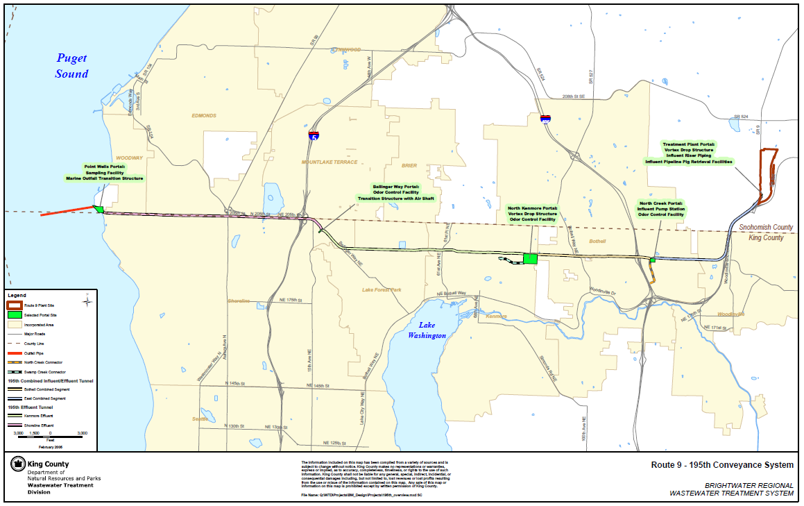
Rt 9 - 195th (Brightwater) Conveyance System

Impacted Parcel Analysis

Lake Hills / NW Lake Sammamish


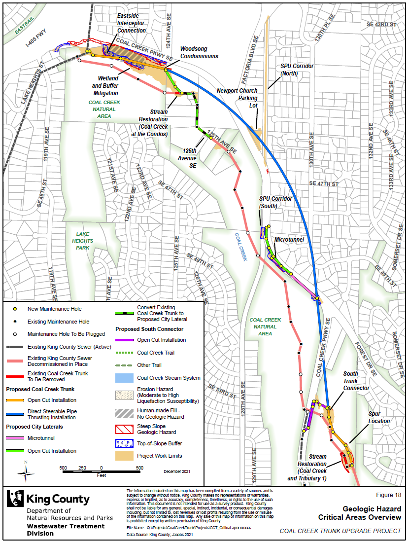
Coal Creek Trunk Upgrade


Georgetown Wet Weather Station


North Mercer Interceptor & Enatai Interceptor Upgrade

Multi-Discipline Data Integration
North Creek Interceptor Sewer Improvement Project

WTD GIS

WTD GIS
Maintain Sewer GIS Data
- FIRS (Facility Information Retrieval System) Data
- Maintenance Hole
- Pipes
- Pump Stations
- Regulator Stations
- Treatment Plants
- Outfalls
- Flow Monitors
- CP Stations
- Connection Points
- Site Plan Data
- 3D Models
- Drone Collected Data
- .... many many more

WTD
GIS
DATA
WTD GIS

WTD
King County
GIS
Data Library
There are 17 county agencies support King County GIS Data Library System
WLRD
Assessor
Road
Program Support
- CSO (Combined Sewer Overflow) Control Program
- Modeling Group
- CIFM (Conveyance, Inspection, and Flow Monitoring) Group
- Asset Management Program
- Capacity Charge
- ....many other sections


Program Support
- CSO (Combined Sewer Overflow) Control Program
WTD GIS


KC & SPU
CSO Real-Time Status Viewer
RainWise
Basin Address Look-Up App
CSO Report
Program Support
- CSO (Combined Sewer Overflow) Control Program
- GSI (Green Storm Infrastructure) --> RainWise Program
WTD GIS


Program Support
- CSO (Combined Sewer Overflow) Control Program
- GSI (Green Storm Infrastructure) --> RainWise Program
WTD GIS


Program Support
- Modeling Group & CIFM Group


Site Investigation Tool
Program Support
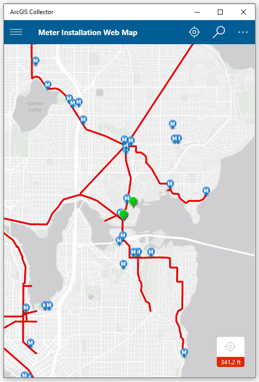
- Modeling Group & CIFM Group
Meter Installation Tool

Program Support
- 3D Modeling Rendering

Program Support
- CIFM (Conveyance, Inspection, and Flow Monitoring) Group

ESJ Support


SVI for Chelan CSO Basin
Program Support


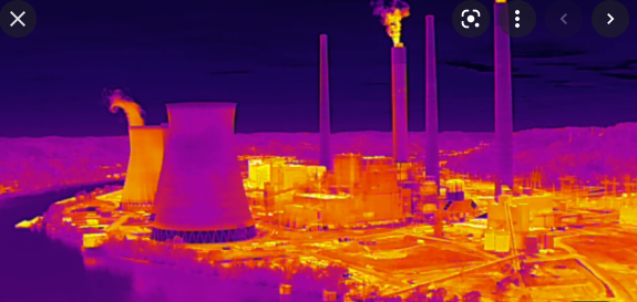
Inspector Gadget
1. Aircraft + Sensor (Data Collection)
2. Data Processing & Analyzing (GIS)
3. Information Products
=
+


Drone Program for WTD

1. Platform + Sensor (Data Collection)
2. Data Processing & Analyzing (GIS)
3. Information Products


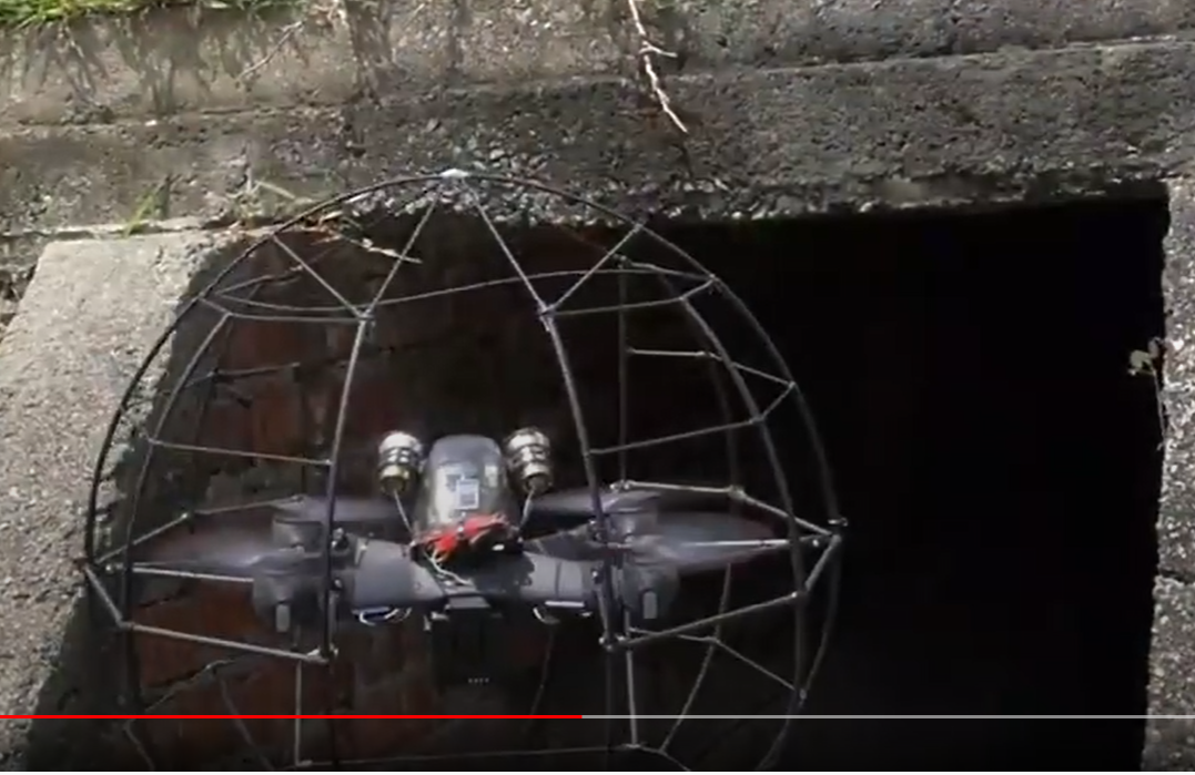
Outdoor
Indoor


King County WTD
August, 2016 - Approved of using 3rd party drone operator (ORM & PA)
April, 2021 - "permissible to operate drones indoor or in confined spaces for specialized uses, like inspections." - Offie Of Risk Management (ORM)
June, 2021 - Approved to Started RPAS Pilot Program in WTD
September 2024
- Four FAA Part 107 Drone Certified Pilots - WTD GIS Specialists (Jim, Patrick, Joe, and Peter)
- Helping other departments to stand up their own RPAS programs


Joe
Outdoor
Indoor
DJI Mavic 2 Pro < $1,800
DJI Mavic 2 Pro Ent. Adv ~ $6,500
DJI FPV w/ Modification ~ $1,300


Mavic 3 Ent
~ $3,800

20 MP/ 56x zoom
20 MP
12 MP/ 32x zoom
+ Thermal

WTD RPAS Dashboard


2021
June - Dec.
2023
Jan. - Nov.
Number of Flights
2022
Jan. - Dec.


+ 480 %
Drone Program
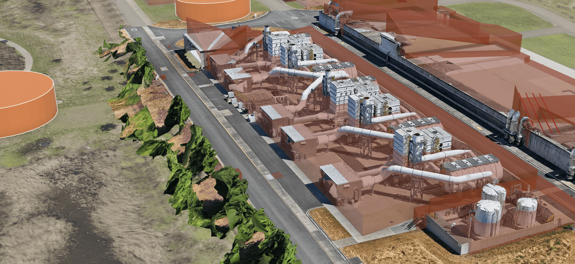
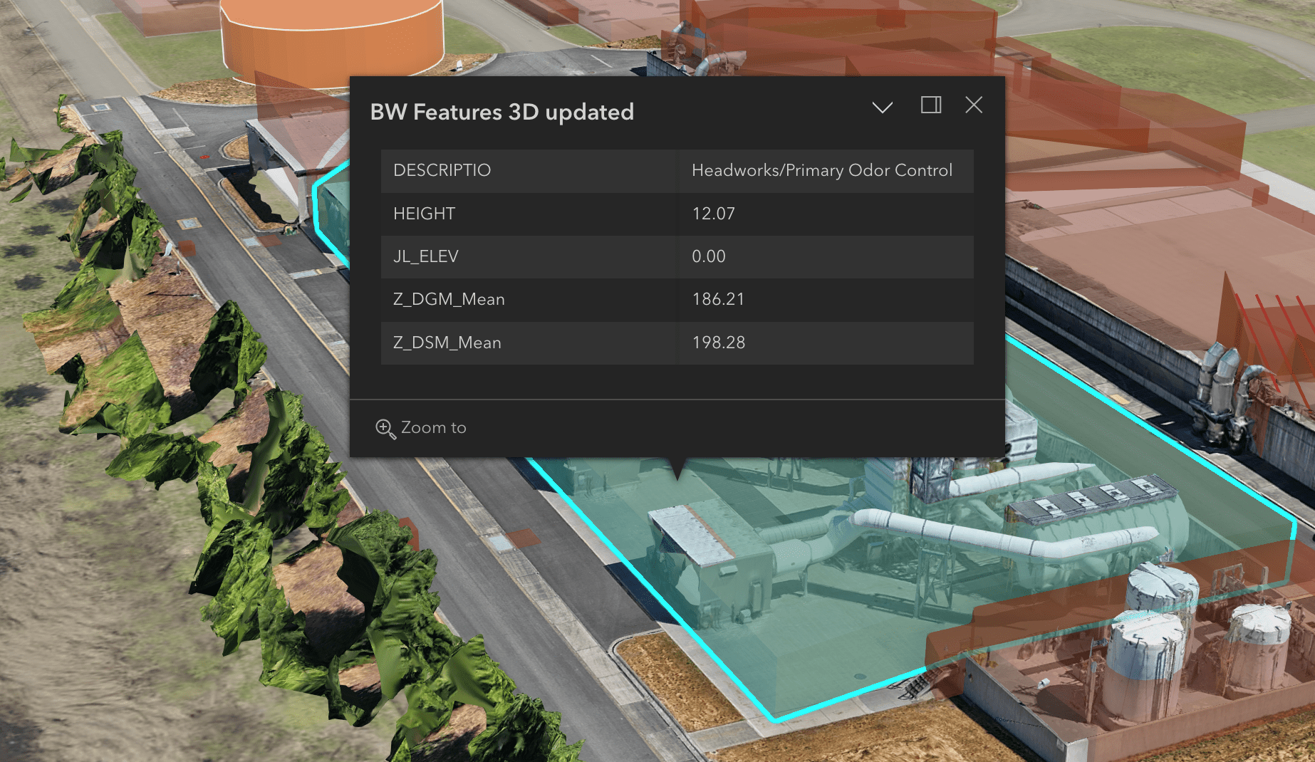
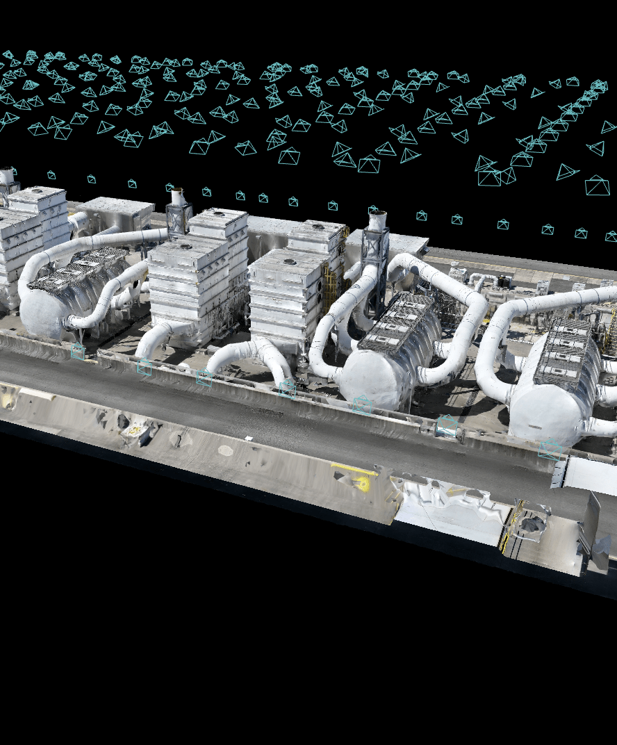
- 3D Modeling Rendering created from Drone imagery then incorporated into GIS system
Drone Program
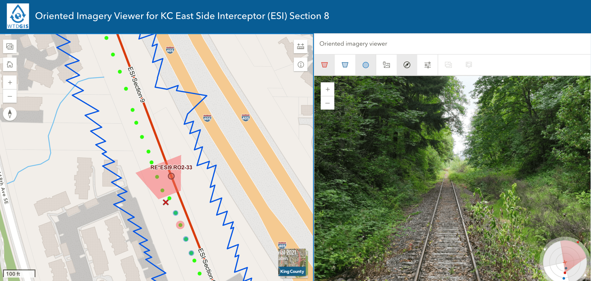
- Oriented Imagery Viewer - ESI Section 8 Segment
Drone Data + GIS
- Make a request, if you know what you need - In-Take Request Form
- Make a request, even if you don't know what you need
- We will help you find the right answer!
How Should You Use GIS?
Part 1: What is it? & Why Use it?
Part 2: How is it being used in WTD?
GIS : Geographic Information System
Is GIS(services)Useful for My Work Here at WTD?

Let's Go Use GIS
&
Find Solutions
Questions?

peter.keum@kingcounty.gov
WTD ETR New Employees Orientation - GIS/Drone Presenation
By Peter Keum
WTD ETR New Employees Orientation - GIS/Drone Presenation
This is part copy of Capital Boot-camp series. Goal is to educate new capital employees in (WTD project, Project, Planning, & Delivery (PPD)) section. This talk is focus on GIS technology by going over what is GIS and how WTD uses to support WTD business. This presentation is made for 2022 Western Washington Short School on June 8, 2022


