Land Conservation Planning
November 5th, 2015
Overview
*Conservation & Trends
*Florida Strategies
*Land Conservation Tools
Land Conservation and Preservation
Permanent protection of land areas by withdrawing them from development.
- Farmlands, fisheries, ecotourism, and working landscapes
- Preserve open space and natural character
- Outdoor recreation, trails, and hunting
- Ecological functions and wildlife habitat
- Mitigation of natural hazards and water quality protection

Source: http://www.nrcs.usda.gov/Internet/FSE_DOCUMENTS/nrcseprd396218.pdf
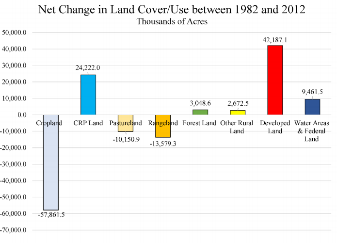
Source: http://www.nrcs.usda.gov/Internet/FSE_DOCUMENTS/nrcseprd396218.pdf
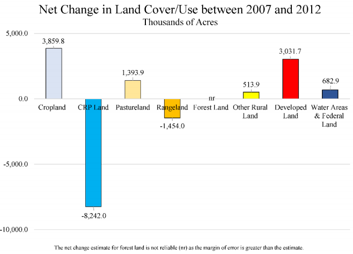
Source: http://www.nrcs.usda.gov/Internet/FSE_DOCUMENTS/nrcseprd396218.pdf
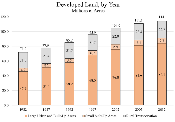
Source: http://www.nrcs.usda.gov/Internet/FSE_DOCUMENTS/nrcseprd396218.pdf
37% of developed land developed in last 30 years
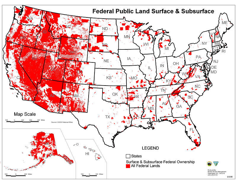
Federally Owned Land
- Federal gov owns and manages roughly 340 million acres
- Four agencies alone manage 610 million
- Under Department of Interior
- National Park Service - 80 million
- Bureau of Land Management - 248 million
- Fish and Wildlife - 89 million
- Under Department of Agriculture
- US Forest Service - 193 million
- Department of Defense - Approx 19 million
- Under Department of Interior
Federally Owned Land Cont.
- 28% of total US land base
- Amount ranges from 0.3% of land in Connecticut to 81% of land in Nevada - And often cause of controversy
- In Florida: 13.1%, or 4.5 million of 34.7 million total acres
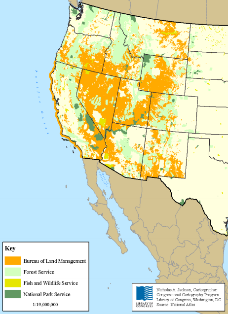
Source: https://fas.org/sgp/crs/misc/R42346.pdf
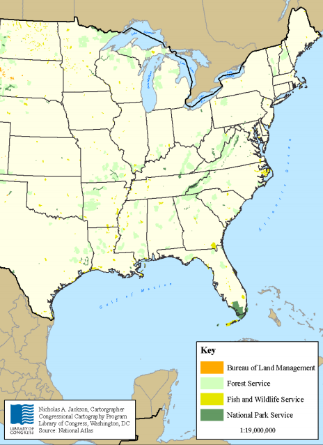
Gaining ground in conservation has moved from federal to state government.
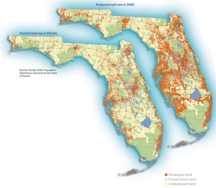
Source: http://flshorebirdalliance.org/media/2093/2060_Pop_Maps.jpg
Florida by 2060
- ~2x population growth, from 19.89 million to 35 million
- 7 million acres projected for conversion to urbanized use by 2060--land area the size of state of Vermont
- Conversion of rural land to urban within 1 mile buffer of protected conservation land-- 2 million acres of that 7 million falls within buffer
- Threat of fragmentation, loss of biodiversity, and significant water management issues
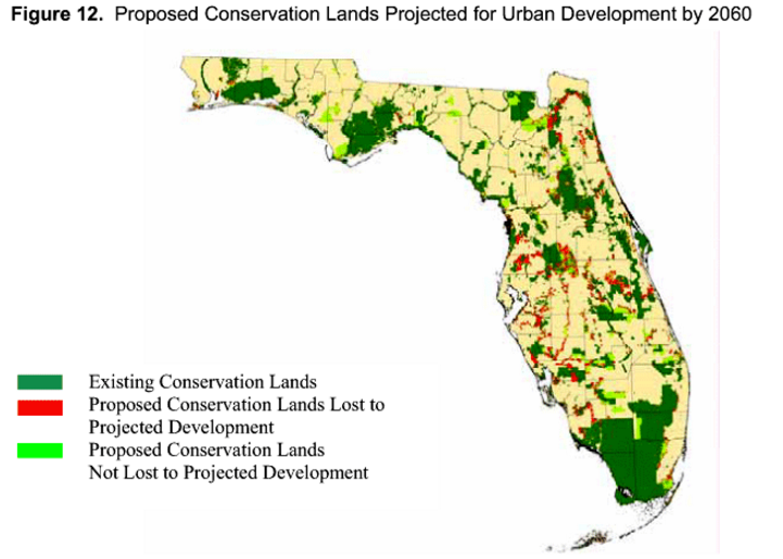
Source: http://www.1000friendsofflorida.org/wp-content/themes/1000freinds/formpop/form-pop.php?q=florida-2060-a-pop
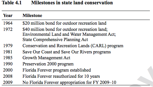
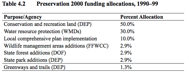
- 1990-2000: Preservation 2000 protected 1.8 million acres
- Substantially increased state's funding for land acquisition to mitigate priorities valued at ~$5 billion
- $3 billion land fund bonded over 10 years, $300 million to spend per year
- Funded via $.17 document stamp increase in compromise with real estate interests
- Late 1990s, Preservation Florida allotment waning. Groups rally to create Amendment 5, constitutional amendment to authorize funding permanently
- 1988: Amendment 5 passes with 72% support. New Governor Bush and bipartisan legislature easily pass Florida Forever Act for another 10 years of funding
- Funds largely for DEP and Water Management Districts
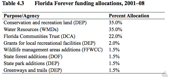
But then: Economic Crash
- Document stamp tax revenues plummet
- Legislature meets in 2009 to cut spending to meet nearly $2 billion statewide deficit. ZERO Florida Forever funding authorized
- Recent years have seen modest gains, from $15 million to $50 million in funding, but partly from sale of state lands and still only 1/6 of previous years
Land Trusts: An Increasingly Popular Tool
- Private, nonprofit organization that, as all or part of its mission, actively works to conserve land by undertaking or assisting in land or conservation easement acquisition, or by its stewardship of such land or easements; or
- an agreement whereby one party agrees to hold ownership of a piece of real property for the benefit of another party
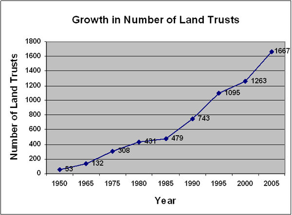
Source: http://www.nationalcenter.org/NPA569.html
Source: http://www.nationalcenter.org/NPA569.html
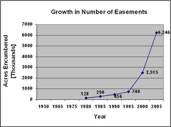
Private Land Trusts
- The Nature Conservancy - 12.3 million acres
- The Conservation Fund - 3 million acres
- Trust for Public Land - 1.3 million acres


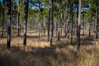
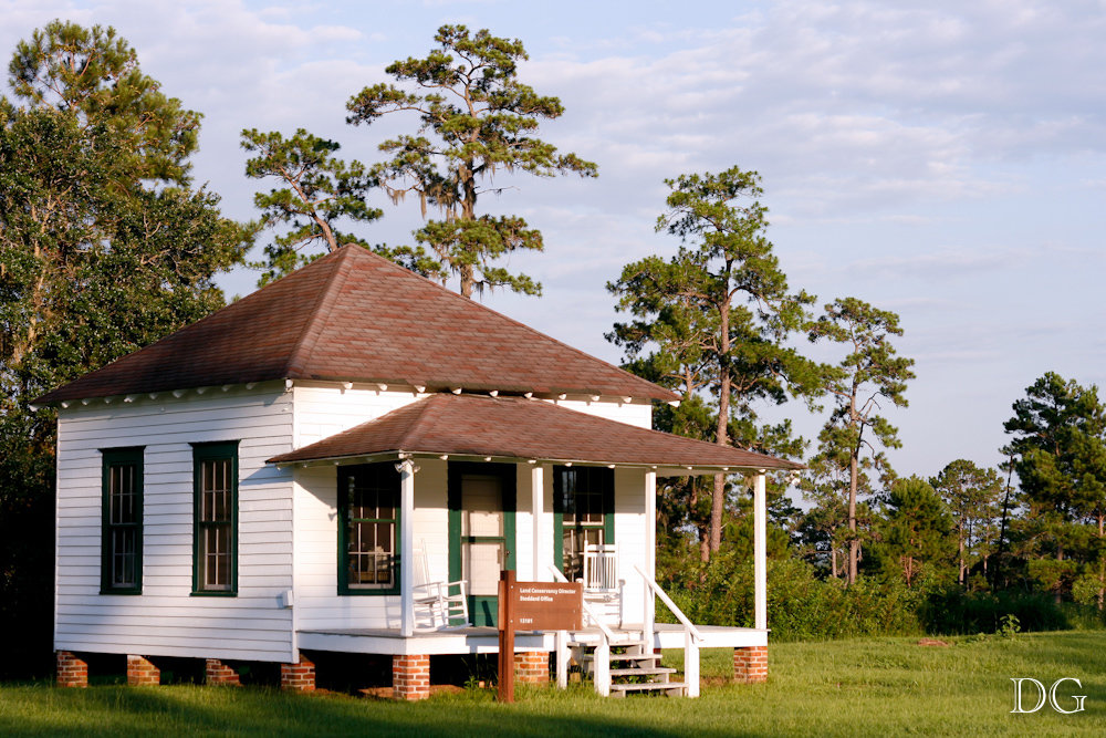
Tall Timber Land Conservacny
- Since the inception of the TTLC in 1990, more than 127,000 acres have been conserved
- Considered one of the premier land trusts in the nation, conserving working forests, farms, and recreational lands in southwest Georgia and north FL
Innovative Arguments for Conservation
-
http://talltimbers.org/red-hills-economic-impact-analysis/
- http://talltimbers.org/red-hills-value-of-ecosystem-services-study/
Tools for Land Conservation
- Acquisition of land and development rights - conservation easements + fee simple purchase
- Open space and greenway planning, green infrastructure, and urban/regional parks
- Agriculture and working landscapes protections
- Education and private land stewardship
Acquiring Land and Development Rights
Fee Simple Purchase
- All rights and title to the property purchased by agency
- Occasionally done below market value via "bargain sale" where some portion of value is donated by seller
- Usually facilitated by a non-profit organization, such as a land trust, because these organizations often have access to funding for land purchases.
Acquiring Land and Development Rights
Purchase with Leaseback, leasing, or undivided interest
- Purchase of land but agency or trust agrees to lease land back to the seller for period of time
- Can provide time for previous owner to transition or simply ensure property is maintained in a certain use
Acquiring Land and Development Rights
Donation or Bequest
- Giving of property to agency or trust, bequest occurring upon death of landowner
- Provides tax and estate planning relief to large landowners, ensures their vision is maintained
Acquiring Land and Development Rights
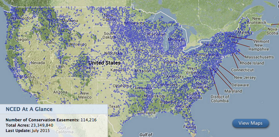
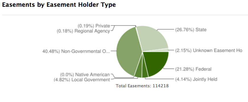
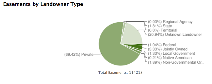
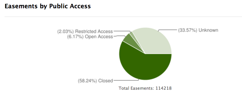
Conservation Easements
- Purchase of development rights from owner (or donation), prevents specific development uses
- Land ownership retained, but easement "runs with the land," meaning it is applicable even after future sale of property to new owners
Source: http://conservationeasement.us/reports/easements
Source: http://conservationeasement.us/reports/easements
Source: http://conservationeasement.us/reports/easements
Source: http://conservationeasement.us/reports/easements
Acquiring Land and Development Rights
Eminent Domain
- Government takes private property for public use with just compensation
- Allows for strategic planning and use, but highly controversial to invoke
Acquiring Land and Development Rights
Transfer of Development Rights
- Release of rights from high-priority conservation area, called sending area, to high-priority development area, called receiving area. Often held in interim by land bank
- Market realities must exist that drive real demand for TDR programs, otherwise they languish
Acquiring Land and Development Rights
Land Exchanges
- Exchange of developable land for conservation land
- Example: AeroJet Land Exchange, 1988. US Fish and Wildlife facilitated exchange of 28,000 acres of BLM land in Nevada for 4,650 acres Florida wetlands owned by the company AeroJet. Land then sold to the South Florida Water Management District
Acquiring Land and Development Rights
Working Landscapes: Exclusive Agricultural Zones
- Must maintain use consistent with agricultural use
- Rarely used, however. It is more vulnerable to legal challenge than non-exclusive agricultural zoning, and, when challenged, more likely to be struck down.
Acquiring Land and Development Rights
Working Landscapes: Non-exclusive Agricultural Zones
- Allows non-farm (residential) dwellings, but strictly limits the number of such dwellings. In addition, non-exclusive zoning often allows the construction of conditional uses if these uses are located on land of low quality for farming.
Acquiring Land and Development Rights
Differential Taxation
- Gives preferential property tax rates to lands held in desired use categories, such as conservation
- Incentivizes conservation - Also available in form of income tax deductions to those that donate via systems like conservation easements
Those are some tools to make it happen.
But what about the planning process?
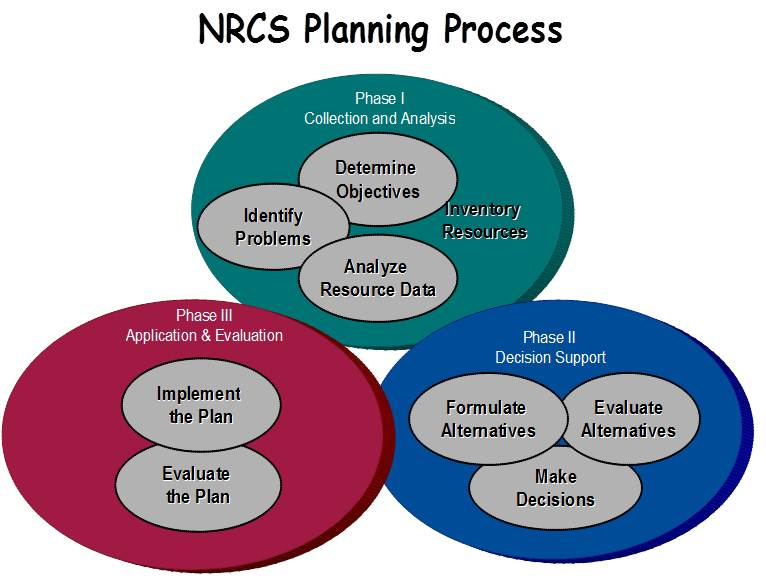
Source: http://www.nrcs.usda.gov/wps/portal/nrcs/detail/national/programs/technical/cta/?cid=stelprdb1049425
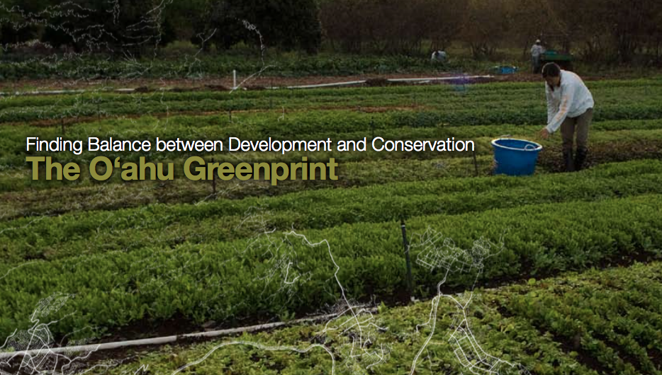
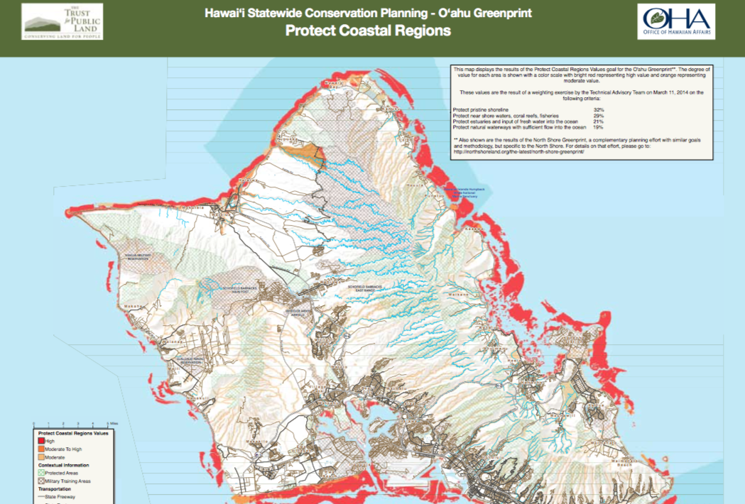
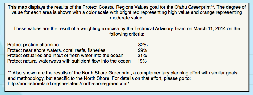
An example in practice: Greenprinting
The best planning is participatory.
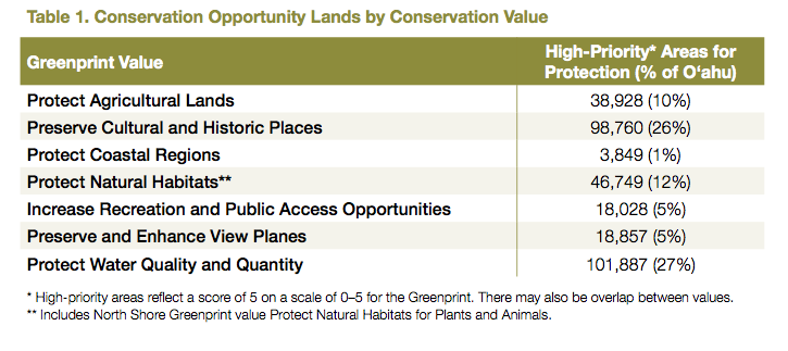
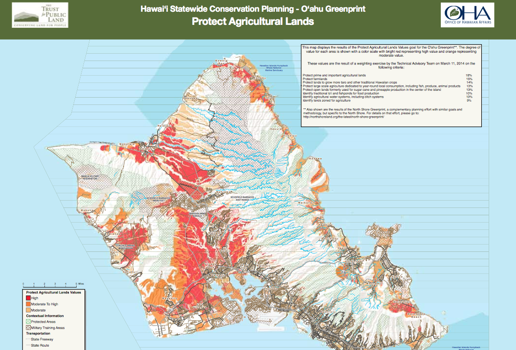
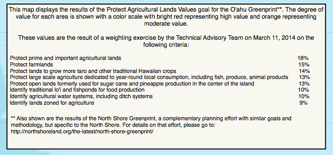
A Greenprint delivers both a long-term vision for conservation and a concrete plan to protect the places most important to a community.
Stakeholder Vision + Quantified Priorities + Implementation = Planning
http://video.esri.com/watch/51/geodesign-in-conservation-planning-stakeholder-driven-geoprocessing-through-greenprinting
Source: https://www.tpl.org/greenprinting
Source: https://www.tpl.org/greenprinting
Source: https://www.tpl.org/greenprinting
Source: https://www.tpl.org/greenprinting
Source: https://www.tpl.org/greenprinting
Source: https://www.tpl.org/greenprinting
Land Conservation
By Lucas Lindsey
Land Conservation
- 1,181


