MAPC PRO
Metropolitan Area Planning Council is a regional planning agency promoting smart growth and regional collaboration for the Metro Boston area.
The Town of Franklin, with the assistance of MAPC (Metropolitan Area Planning Council) and the Town's consultant BETA, Inc., are pleased to welcome you to a virtual slide show of the Dellea Agricultural Property. This tour includes an interactive Google Earth Tour, images, videos, and other information about the property as well as some highlights of potential uses.
To view the slide show, click on the arrow in the bottom right corner of your screen or click the right arrow key on your keyboard.
Since the adoption of Franklin's Master Plan in 2013 the Town has made significant progress implementing projects and improving open space and recreation resources. The Town has developed a community garden and implemented an Agricultural Commission. Acquiring the Dellea Property offers Franklin an opportunity to continue that progress. This tour showcases some of the existing and potential agricultural and recreational uses of the area.
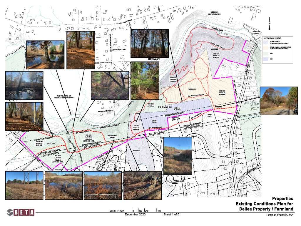
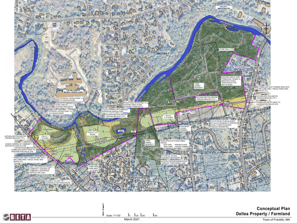
The area encompassed by this project includes two privately owned agricultural parcels (the Dellea Property) which are adjacent to four Town-owned parcels. As you can see on the map, these parcels are located in the north of Franklin and border the Charles River. Most of these parcels are currently woodland or cleared for power lines or agricultural uses. Combined, the six parcels total over 98 acres and border one mile of the Charles River
Click on the image below to see a larger version.
The Dellea Property is currently privately owned. The current owner uses the unwooded portions of these parcels primarily for generating hay and other agricultural uses and has a forest management plan in place for the wooded areas of the property. An Agricultural Restriction means a perpetual restriction to retain land or water areas predominately in their agricultural, farming, or forest use, and forbids or limits certain property development rights and uses. In addition, the property is currently under an agricultural restriction under Massachusetts General Laws Chapter 61A. The next slide contains an interactive map of the project area and the Dellea Property, which are highlighted in purple.
MGL 61A
According to the Massachusetts Department of Revenue, the "Massachusetts General Laws Chapter 61A is designed to encourage the preservation of the Commonwealth’s valuable farmland and promote active agricultural and horticultural land use. It offers significant local tax benefits to property owners willing to make a long-term commitment to farming. In exchange for these benefits, the city or town in which the land is located is given the right to recover some of the tax benefits afforded the owner and an option to purchase the property should the land be sold or used for any purpose other than to continue raising farm products."
Use the + and - buttons in the lower left to zoom in and out.
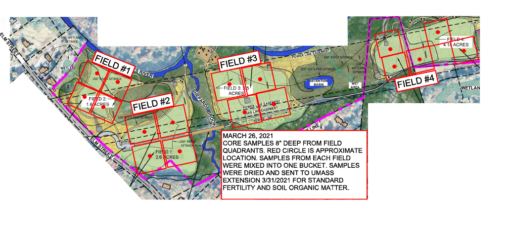
The Dellea Property contains four fields that are utilized for agricultural purposes (shown in Green)
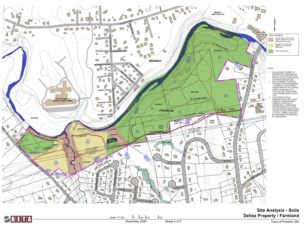
According to an initial analysis completed by the Town, much of the soil on the property is considered prime farming soil (the green). The yellow-colored parts of the property are considered moderately suited for framing while the red portions are considered poorly suited for farming. On the next slide you can view an image of where the soil samples were taken on the property.
Click on the images below to see larger versions.
The below image indicates where on the property soil samples for testing.
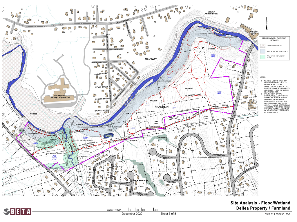
Because of the property’s location in proximity to both the Charles River and several wetland resources, a substantial amount of the area falls in resource area buffer zones. In areas abutting a river or perennial stream there is a 200 foot outer riparian zone and in other areas there is a 100 foot buffer zone bordering isolated vegetated wetlands. What this means is that any activity within these zones could impact these water sources and thus would require Franklin to obtain a permit from the Town’s Conservation Commission. To view the consultant’s Flood/Wetland site analysis of the area, which includes the specific butter zones, click the image to see a larger version.
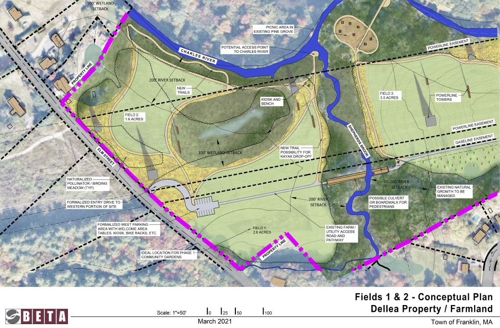
This field, near the west end of the Dellea property (in green), is currently (2021) being leased by a local farmer. Previously the field was used to grow pumpkins and other gourds and to generate hay.
This field, on the west end of the property, marked in green on the map, is currently being used to generate hay.
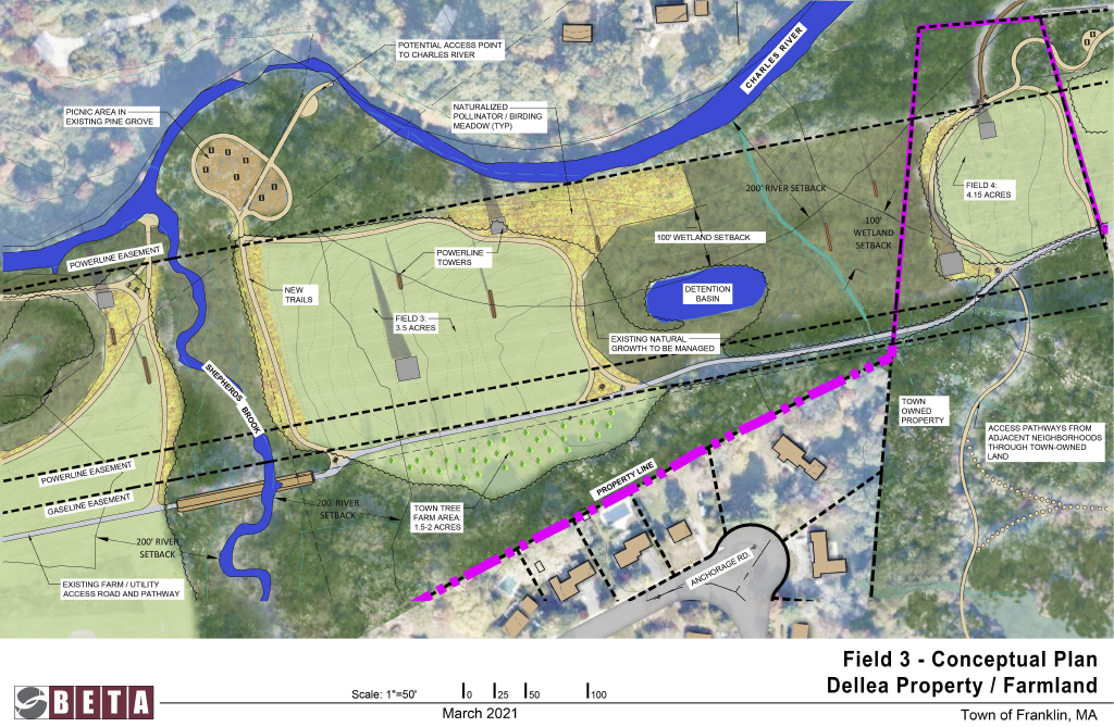
This field, located near the center of the Dellea Property and marked in green on the map, is currently used for hay.
This field, marked in green on the map, is located on the Dellea Property and is currently being used for leased farming.
The four parcels owned by the Town, marked on the interactive map below with the light blue line, are used for passive recreation and natural resource protection and could be combined with the Dellea Property to form one contiguous publicly accessible area.
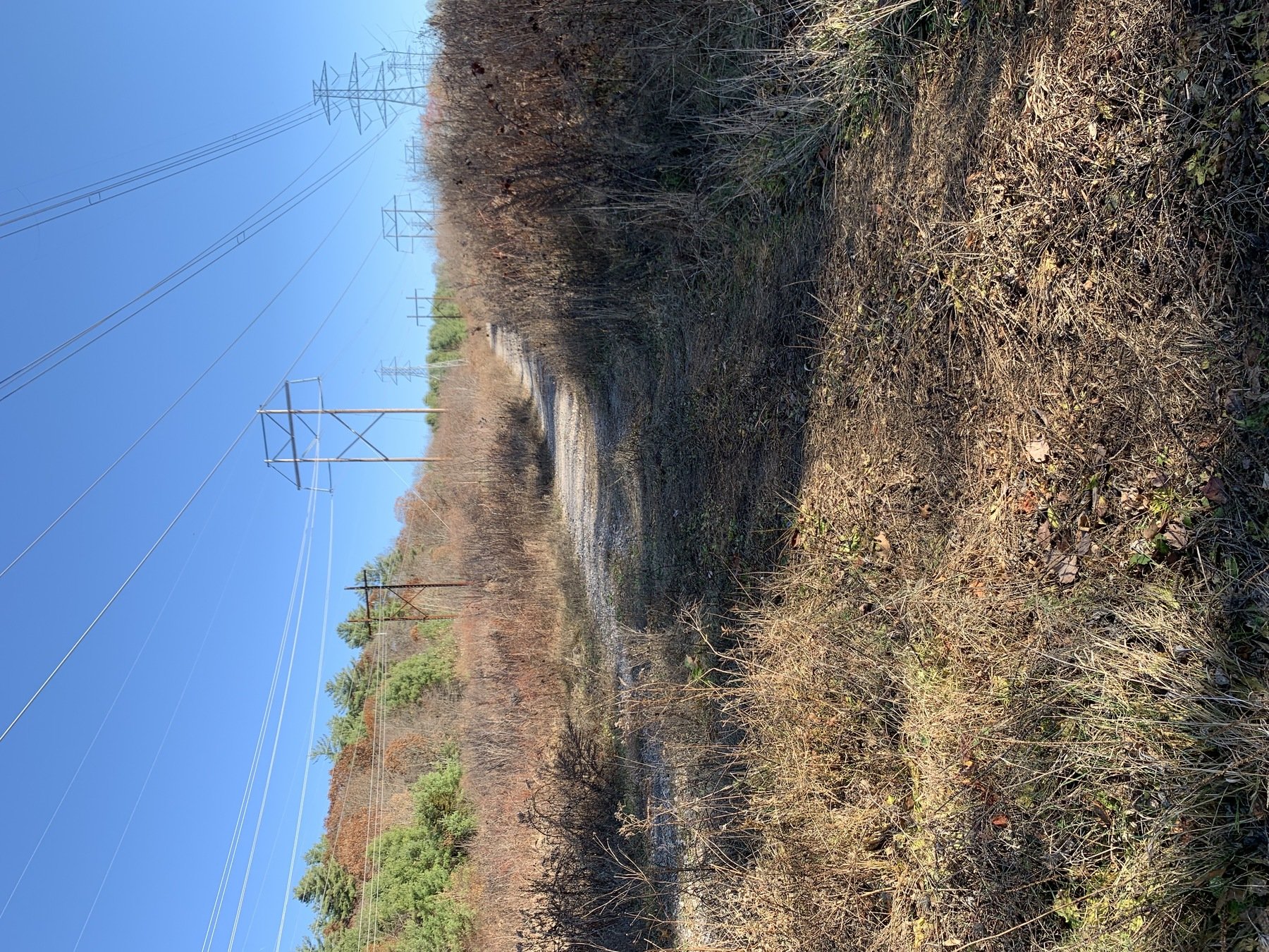
The Town constructed a parking area on its Riverbend property off of Lincoln street along a powerline access road. This parking area will continue to serve as the eastern access point to the property. Below you can see an interactive map with the parking area in gray and a Google Streetview of the existing access road.
This existing gravel road starts at the parking lot off of Lincoln street, passes over four adjacent residential properties, and continues to the middle of the Dellea property where it links with existing cart paths. The access road and connected cart paths provide access to fields 3 and 4.
Click the below video to view aerial footage looking at the Dellea Property from Lincoln Street to the west over the existing Town Parking area.
The Dellea Property's western end is bordered by Elm Street. Play the below video to view aerial footage looking at the Dellea Property from Elm Street going towards Shepards Brook and the surrounding wetlands.
The Town has drafted a conceptual plan for the area which describes a slew of different uses for the Dellea Property and the adjacent Town-owned parcels. This portion of the virtual tour begins with an overview of the potential agricultural uses in the plan and then showcases the potential recreational amenities across the property.
The Town’s conceptual plan for the site is based on the existing conditions, existing easements and restrictions, and the area’s soil suitability. The plan also details possible locations for additional community agricultural spaces, trails, and other amenities. This conceptual plan also identifies several opportunities to connect the area to adjacent neighborhoods.
As discussed earlier, the Dellea Property is currently under an agriculture restriction that would continue to exist should it be purchased by the Town. The Town expects agricultural activities will include the following:
Proposed Pollinator and Birding Meadows (yellow) and location of four existing fields (green)
Across the property there are existing meadows that can provide environments for pollinators and birds to thrive while enhancing the existing area without requiring invasive development or significant changes to the existing landscape.
These areas can provide important habitat for pollinators such as hummingbirds, bees, butterflies etc. The plants can provide food for them such as nectar, pollen, seeds and fruit. The meadows also provide shelter for resting, nesting, and raising young. In addition, mammals such as mice and rabbits can also find a lovely home in this meadow and help to spread pollen. With all this wildlife attracted, new growth of flowering plants will follow, enhancing the quality of the space for visitors. Lastly, transforming these meadows into areas for birds and pollinators can help to manage existing invasive or undesirable plant species in the area.
A Town-owned parcel near the center of the Dellea Property (in orange) contains a field to the west of Field 4 that is an ideal location for uses like a dog park, a tree farm, leased farming, birdwatching, or community agriculture. If the Town purchased the Dellea Property these two fields could be combined to form one larger area for leased farming or community supported agriculture.
The conceptual plan identifies this area (in orange) as a potential location for a tree farm on the property. The area, which is adjacent to field 3, can be utilized for other agricultural uses if a tree farm is not desired.
This portion of Field 1 (in orange) provides an ideal location for a community farm or garden plot. Because of its location near a proposed parking area, this plot would be easily accessed by visitors and gardeners alike.
This parking area (in gray on the map) will provide direct access to the western part of the property. The below interactive streetview is what the area looks like currently.
This area, which is owned by the Dellea family, is currently being leased to grow vegetables and grow and sell hay. Both of the fields on this property (Field 1 and Field 2) could be used for community supported agriculture or for continued leased farming. The lower field, Field 1, is ideally suited for community gardens or community agriculture and includes the potential community garden area.
Like the other fields, these fields are surrounded by potential pollinator/birding meadows (marked in yellow).
Click on the image below to see a larger version.
This area includes portions of both the Dellea Property and the Town owned property. The large field in the center of the area, Field 3, is currently being used to make hay and is on the Dellea Property. The field could be used for leased farming or for community supported agriculture.
The areas on either side of the field could be used for pollinator/birding meadows (marked in yellow). Directly south of the large field is a potential location for a Town tree farm (marked with small trees).
Click on the image below to see a larger version.
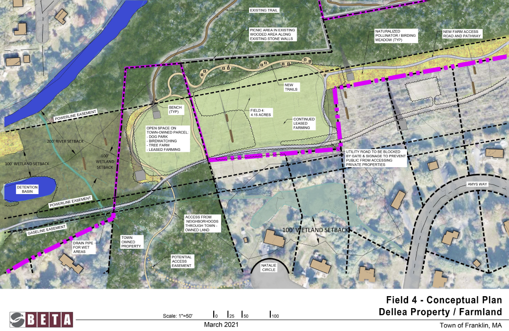
This area includes portions of both the Dellea Property and the Town-owned property. The Dellea Property, which includes Field 4, is currently being used for haying. The size of the field could be increased to include a portion of the adjacent Town-owned property. The Town's property could accommodate a dog park, tree farm, birdwatching areas, and/or leased Farming. This area could also accommodate a pollinator/birding meadow (marked in yellow).
This area also includes the west end of the existing Riverbend Trails network which could be connected to the proposed trails on the Dellea Property.
Click on the image below to see a larger version.
In addition to the agricultural uses, the conceptual plan identifies potential recreational opportunities for the area should the Town purchase the Dellea Property. The proposed recreational resources include:
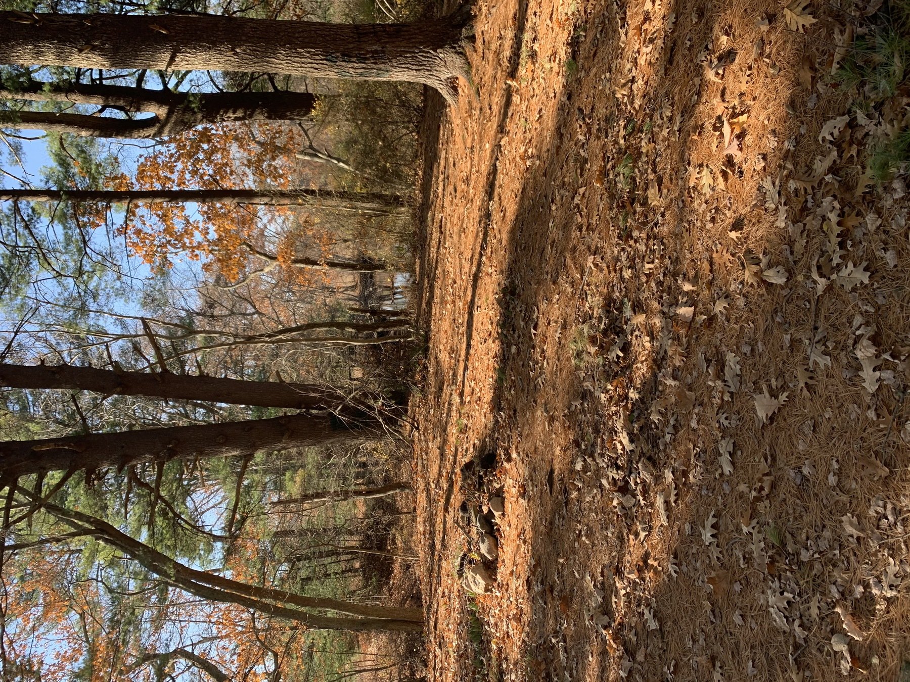
The Conceptual Plan proposes an extensive new trail network that runs the length of the area, connecting the various existing proposed agricultural and recreational amenities to the pollinator meadows, the riverfront, and the surrounding community. Click through the below photos to see some of the existing areas where the trails and other passive recreational assets would be located. The first images are of the conceptual plan itself, where you can see trails in more detail (the tan lines).
The existing pine grove near Shepards Brook and the Charles River provides an area ideal for a picnic area and other passive recreational resources.
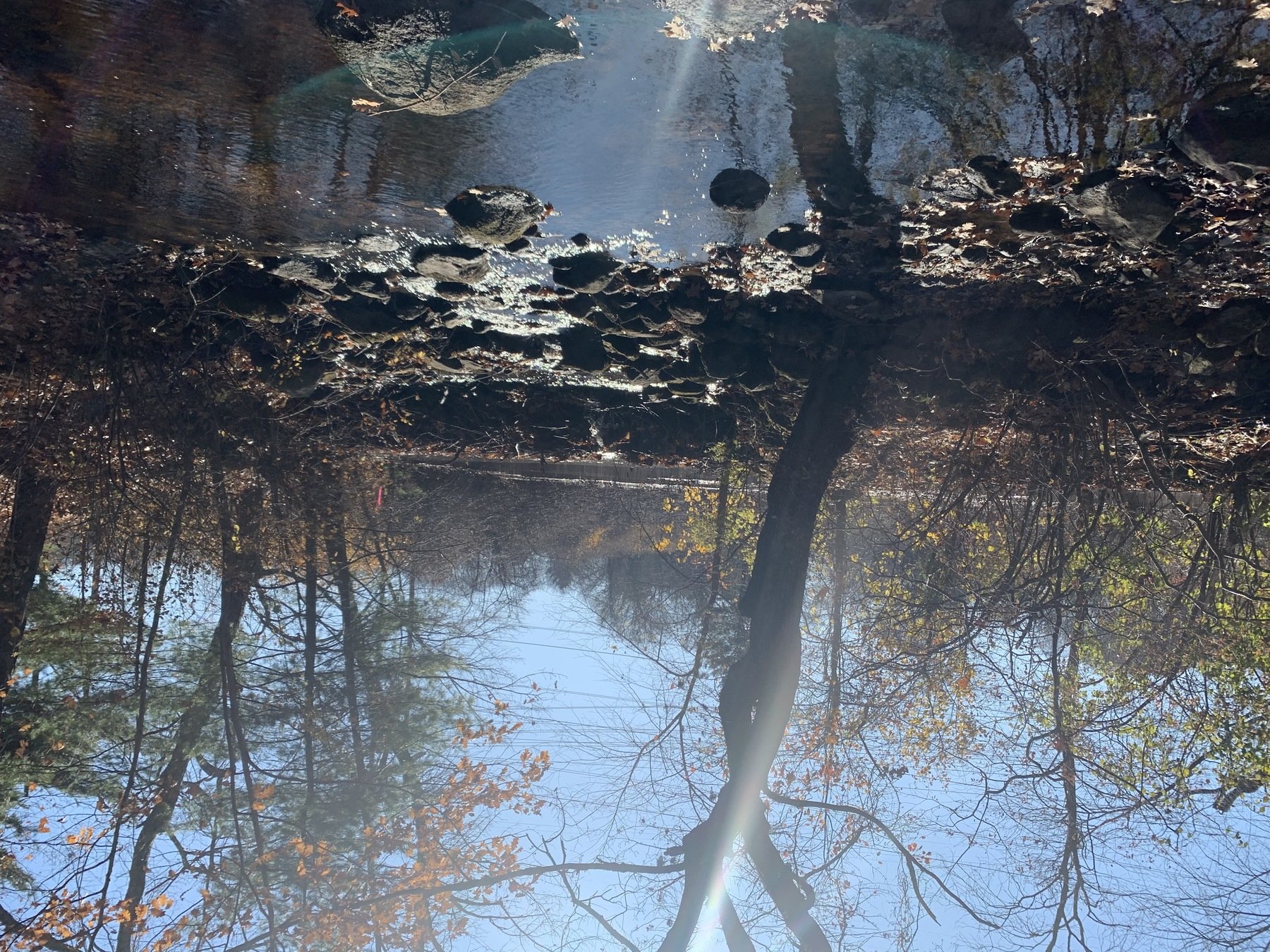
Potential River Access Point #1,Entrance to Shepard's Brook
The mouth of Shepard's Brook provides a possible access point to the Charles River and could serve as a kayak/canoe launch. The above photo shows what the area currently looks like.
There are several different existing amenities, either adjacent to or near by the Dellea Property, which complement the potential uses already mentioned. A few are mentioned on the following pages.
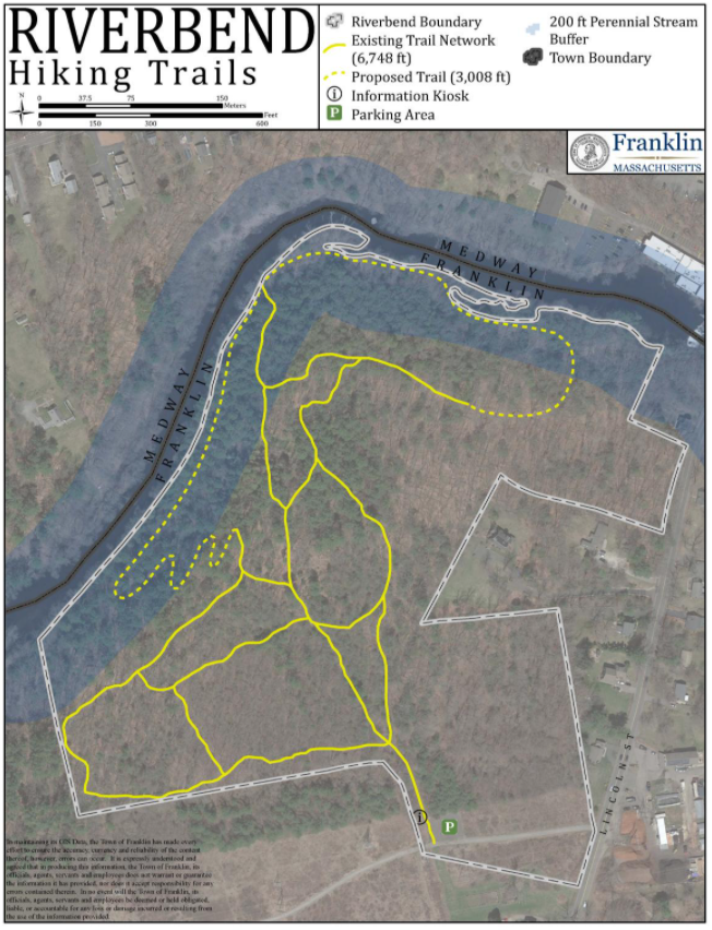
The Riverbend Hiking Trails (in brown), are on three Town-owned properties with access from Lincoln Street. There is parking and an information kiosk available.
These trails could be expanded on to the Dellea Property, adding to the already existing trail network in Franklin. Click on the trailmap image on the right to view a video of the entrance.
The Charles River Farm, located on Elm Street, is a nearby local farm owned and operated by the same owners as the Dellea Property. Charles River Farm is home to a high-quality brand of micro-greens known as Charlie Rivers which supplies restaurants with fresh, local produce.
The Fairmount Fruit Farm is a local farm on Lincoln Street. Fairmount Fruit Farm has been providing the community with the finest quality goods since 1920. The farm provides fresh vegetables, fruits, and eggs. they also have a store that provides meats, homemade pies, cheese, and dairy products. There are an abundance of fresh annuals and perennial flowers for sale as well.
In addition to the Riverbend Hiking Trails, the Town-owned property near the center of the Dellea Property could provide a trail connection to Berkley Drive, creating an access point for neighboring residents to the south.
Thank you for your time and interest in the future of the Dellea Agricultural Property! We hope this tour was informative. If you have any questions, please reach out to Bryan Taberner, Director of Planning and Community Development at btaberner@franklinma.gov
Fairmount Fruit Farm is a local farm on Elm Street neighboring the Dellea Property. The google streetview below shows the Fairmount Fruit Farm entrance.
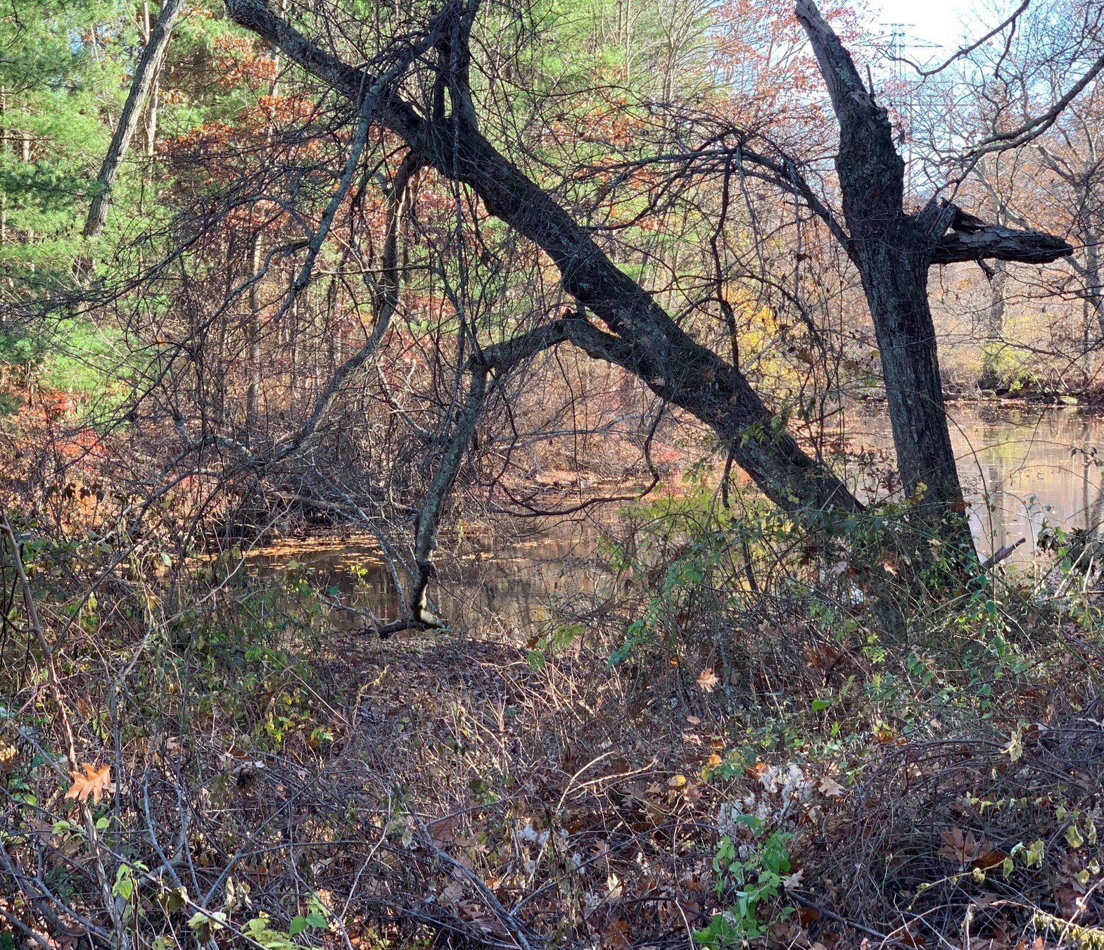
The bend in the river offers a possible location for an additional access point. Photo above shows what the area currently looks like.
The bend in the river offers a possible location for an additional access point. Photo above shows what the area currently looks like.
The Town owned property could provide a connection (the light teal line) to Berkley drive and can create an access point to the neighboring community and for the public. This connection would also connect to the existing and proposed trail networks. Currently, to get to the trails, residents must walk to and then along Lincoln Street, which does not have sidewalks.
By MAPC


