Small Unmanned Aerial System (sUAS)
Drones, What are they Good for?
Innovation Day - July 31, 2018
Peter Keum - WTD GIS Specialist, GISP
peter.keum@kingcounty.gov
Just another tool in the toolbox

@pkeum
Innovation Day
Innovate = To do something in new way
Improve = To do something better
Invent = To create something from nothing
New way not necessarily Better
-
Introduction of sUAV & Use Cases
-
FAA & King County (WTD)- Regulations & Guideline
-
KC WTD Use Cases

small Unmanned Aerial Vehicle (sUAV) System
UAV - Unmanned Aerial Vehicle
FAA Definition: Unmanned Aircraft (UA) system that is operated by a pilot via ground control or on-board computer.


1. Introduction of UAV
sUAV as Platform

Multi-rotors
Fixed wings

- Short flight time (< 20min)
- Cover small area
- Highly maneuverable
- Less expensive
- Access to confined spaces
- Long flight time (+ 30min)
- Covers large area
- Larger selection of sensors

Sensors


Multi-spectral
Thermal Infrared

Lidar Camera

High resolution digital camera


Workflow
1. Drone + Sensor (Data Collection)
2. Data Processing & Analyzing (GIS)
3. Information Products

||
+
Benefits
-
Temporal Resolution
- Can fly often
Offer decision makers with appropriate analytic information products
-
Spatial Resolution
- Monitor continuous changes
- High Spatial resolution than Satellite, Plane
- More Data > More Knowledge > Better Decision Making


Regulations - Where are we now?

2. Regulations
King County WTD
"Subject: WTD Policies on Use of Small Unmanned Aircraft Systems (Drones)
Managers/Supervisors: August, 2016
I’d like you to share the following policy guidance regarding the use of drones for work purposes with your staff as appropriate. The guidance specifically addresses the use of drones classified as small unmanned aircraft systems (UAS), which weigh less than 55 lbs."
-
No owning or operating drones by WTD
-
Manager/Supervisor review and require Division Director approval
-
3rd Party to meet KC Risk Management requirements
Commercial/Governmental
FAA Part 107 Rule, July 2016
-
Need FAA Remote Pilot Certification (Pilot license NOT needed)
-
As of September 2017 -60,000 active remote pilot certificates
-
Fly under 400 feet above ground level
-
Not to fly < 5 nautical miles around airport
-
Aircraft < 55 lbs.
-
Fly during daytime
-
Fly visual line of sight ( VLOS)
-
No flight over non-participating people
FAA Part 107 Rule

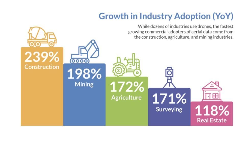
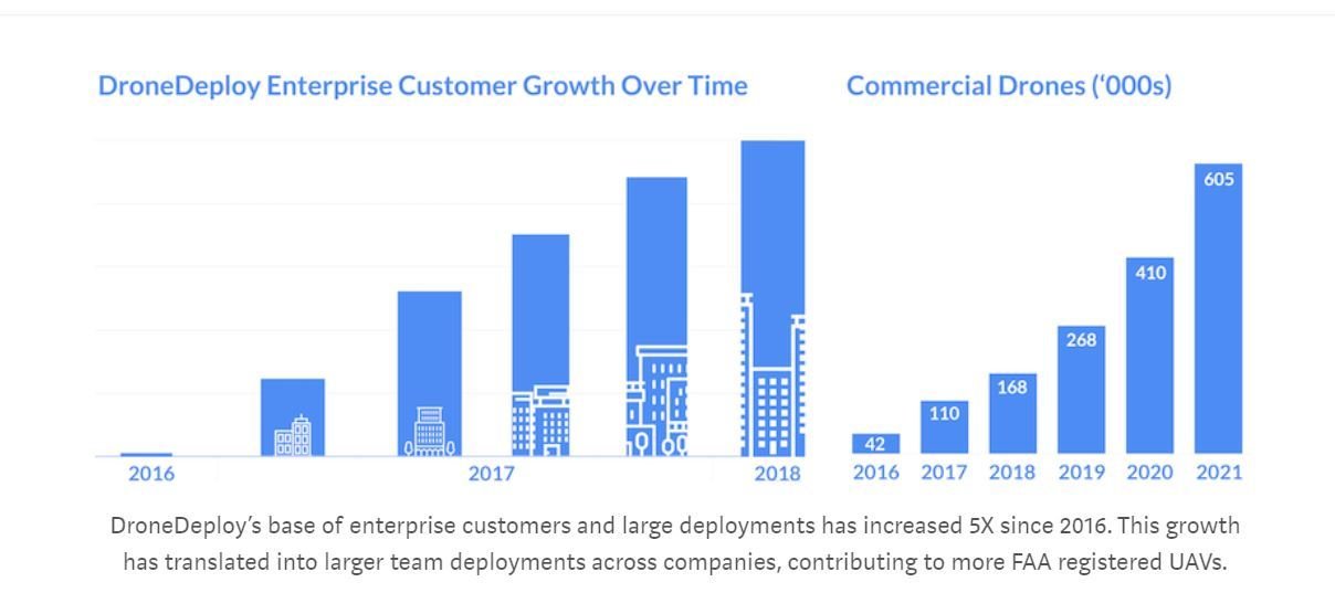
2018 Commercial Drone Industry Trends
3. WTD Projects
-
West Point Treatment Plant Event
-
Floating Willow Raft (Brightwater TP)
-
West Point Treatment Aerial Photography
-
Environmental Monitoring for Regulatory Reporting (3 Project sites)


WTD Projects
-
West Point Treatment Plant Incident Feb, 2017
Drone Flights = Clarification


Photo from Seattle Times
KC WTD Drone Flight
March, 2017
WTD Projects
-
Floating Willow Raft Shade Study

- 4 Flights 2017
- Consultant flys and generate shade analysis & report
- KC staff as an observer and in-house expert to develop work order & product review
WTD Projects
-
West Point Treatment Plant Orthophoto

- October 2, 2017
- Over 600 images collected
- High Resolution 0.75 inch/piexel


WTD Projects
-
Environmental Monitoring for Regulatory Reporting (3 Project sites)
- Brightwater Treatment Plant
- Kenmore Portal
- North Creek Interceptor
- Providing Very High Resolution Vegetation Photos
- Saving Staff time during detail site inspection

END
for now
Thank You
peter.keum@kingcounty.gov
KCIT - "Day of Innovation" Drone Presentation
By Peter Keum
KCIT - "Day of Innovation" Drone Presentation
Innovation Day Presentation for KCIT on Drone - August 1, 2018


