


Marc Compte
GIS lover. Web developer. Working at the GIS Service in the University of Girona (http://udg.edu/sigtehttp://udg.edu/sigte and freelance.
UNIGIS is a worldwide network of universities cooperating since 1990 in the design and delivery of distance learning in Geographical Information Systems and Science.
UNIGIS is a university.
Each year we enrol more than 400 students world-wide.
We have over 4.000 UNIGIS alumni in more than 40 countries.
Area: 39.1 km2
Elevation: 76 m
Population: 101,852 (2019)
The spanish node
Hosted by the GIS service (SIGTE) of the University of Girona since 1999
~80 enroled annually
>1500 alumni
Spanish
Programmes
MSc
GIS
Programming
Analysis
+
Thesis
+
Programming
Python
Webmap
Network & Interoper.
GeoDB
~2 months per module
100% remote
Courses start and end at specific dates
Content updated annually
Assignment oriented learning
Case studies, webinars, exercises,...
Online materials & tutoring
Resources oriented to assignments
Course features
Student profile
Geo backgrounds
Mostly non-programmers or beginers
Basic JavaScript knowledge
~15 enroled yearly
25% dropouts
High gender bias (75%-25%)
26 < most common age < 45
Abilities learned
Using external APIs in the code
Experience with core data types
Read & write files & databases
Use a standard style (PEP8)
Modules, classes & functions
Create an interactive QGIS plugin
Basic usage of spatial libraries
1. Read a CSV & report
2. Find closest amenities
3. Create a QGIS plugin
Assignments
1. Introduction
2. The language
3. Spatial operations
4. Extending QGIS (plugins)
Content
1. Introduction
1. Why Python?
2. Description
3. Setup
4. Hello World + goodies
Content
1. Introduction
3. Setup
Based on OSGeoLive
troubleshooting
learning
Content
2. The language
1. Syntax & Style
2. Data types & flow
3. Classes & modules
4. Error management
Content
3. Spatial operations
1. GDAL-OGR-OSR
2. Fiona, shapely, PyProj
3. Sample exercises
Content
4. Extending QGIS
1. Python console
2. PyQGIS
3. PyQt
4. Plugins
Content
Student evaluation & feedback
Rated 90% in difficulty
40-50% use the extra time
Rated 90% as professionally useful
High dedication rate
High initial dropout rate
Highly rated assignments
Standard overall dropout rate
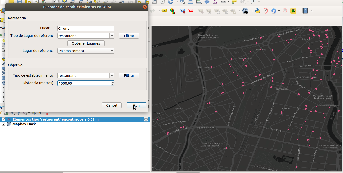
An example
GIT
reStructuredText
Sphinx
Moodle
Backstage
Questions?
Teaching GeoPython remotely at UNIGIS Girona
It allowed me to learn in depth the technologies and concepts behind GIS, something not all computer scientists know about
José Manuel Cantera
This programme gave me a broader understanding of the GIS applications and taught me to think spatially.
David Hernández
The e-learning platform offers the resources for a good learning process (Webinars, forum,...) and promotes the networking and collaborative work.
Paula Burillo
The tutoring is fantastic and gives proper and timely answers. There's also a nice companionship among students, helping each other on the forum when possible.
José Manuel Cantera
At first, one is afraid of feeling alone, but then you see there's a group of people doing their best to help you out and let you grow at your own pace, which is what I value the most.
Rebeca Fresnillo
The programme requires you to make sacrifices and be organized, but this also crucial in today's life. The level of rigour I missed in my previous GIS studies I found it here.
Magí Pàmies
By Marc Compte
How do we teach GeoPython remotely in UNIGIS Girona's MSc.


