Geographical scales of economic inequality
Dr. Clémentine Cottineau, , Centre Maurice Halbwachs
Seminar at 28th October 2019


Bio.
> Trained in Geo + Eco
> PhD about urbanization in the post-Soviet space
Open Data, Statistical models, ABM, shrinkage
> Post-Doc on urban scaling laws & city definition
Systematic delineation, mobile phone Data, agglomeration economies
My
Project
Analyse the dynamics geography of urban inequality by linking together the economics of (national) inequality with the sociogeographical work on (urban) segregation
% income
% pop
Gini
Analysed for citizens
spaceless countries
- Plethora of measures available (Gini, 1%, capabilities, etc.)
- Considers dynamic relations with macro indicators (GDP, demographic growth, interest rate, etc.)
- Considers dynamic relations with micro indicators (years of schooling, gender, household, housing tenure, etc.)
Economic Inequality
Economic segregation
analysed for single cities
- Plethora of measures available (multigroup, multilevel, egohoods, etc.)
- Conceptualisation of the link between individual level and neighbourhood level (neighbourhood effects)
- Correspondance between segregation level and other city-level characteristics (Logan, mobility, social network)
Urban segre-gation
URBAN
SEGREGATION
ECONOMIC
INEQUALITY
The distribution of groups in the country (inequality) constrains the group composition of each city
Neighbourhood effects affect the individual incomes and thus the overall distribution
Evident causal relations
between the two fields
They also share a pool of common explanations
URBAN
SEGREGATION
ECONOMIC
INEQUALITY
Schooling
Health
Inheritance
Housing
But the overlap is incomplete
URBAN
SEGREGATION
ECONOMIC
INEQUALITY
Population outside cities
Effect of space on income
Interaction at city level
Interaction at national level
Feedback loops of capital
Intermediate level of analysis
The urban landscape
as a dynamic field
One solution to reconcile them
Population outside cities
Effect of space on income
Interaction at city level
Interaction at national level
Feedback loops of capital
Intermediate level of analysis
The urban landscape
as a dynamic field
One solution to reconcile them
Population outside cities
Effect of space on income
Interaction at city level
Interaction at national level
Feedback loops of capital
Intermediate level of analysis
Delineating cities
Linking all scales dynamically
Making city delineation obsolete
> CRUCIAL BUT UNRESOLVED PROBLEM OF URBAN STUDIES
Institutional and political boundary
Physical limits
of built-up area
Functional areas of
integrated urban society
- City delineation captures the spatial extension of a certain definition (what we mean by city). Cf. Parr, 2007
Paris
10 km
30 km
~100 km
Making city delineation obsolete
> CRUCIAL BUT UNRESOLVED PROBLEM OF URBAN STUDIES
- The type of definition and delineation thresholds determine measured urban quantities and influence co-variations
Zipf's Law
Rosen & Resnick, 1980
Soo, 2005
+ Cottineau, 2017
Urban Scaling laws
Arcaute et al. 2015
+ Cottineau et al., 2017
+ Finance & Cottineau, 2018
Agglomeration Economies
Briant et al., 2010
Meijers & Burger, 2017
+ Cottineau et al., 2018
Social networks, mobility & segregation
Cottineau & Vanhoof, 2019
Urban morphology & segregation
Spielman & Harrison, 2013
+ Raimbault et al., 2018
Making city delineation obsolete
> CITIES and INTERURBAN links through a geographical fields approach
- Urban models need to consider the presence of other cities
- Individuals are the main actors navigating the landscape
- Cities still identifiable as intensity peaks

Work in progress
with J. Delloye, U. Lux.
Linking geographical scales of inequality and segregation dynamically
CONCEPTUALLY
EMPIRICALLY
A library of explanatory mechanisms
A multi-model to simulate them
Methods to explore and select sub-models behaviour
Network theory as a tool to detect multi-scale clusters
From geoindustrial clusters
to segregation clusters
A library of explanatory mechanisms for inequality
cf. https://unequalread.hypotheses.org/
1 book review every 2 months
| Mechanism | Temporal scale | Spatial scale |
|---|---|---|
| Unequal return rate on wealth ('Rich get richer') | month / year | (inter-) national |
| Intergenerational inheritance and demographic growth | decade | national |
| Redistribution through income tax and welfare | year / decade | national / local |
| Public education and health services | year / decade | national / urban |
| Social norms and family aspirations | year / decade | local |
LITERATURE REVIEW -
along with space-time scales involved
A library of explanatory mechanisms for inequality
cf. https://unequalread.hypotheses.org/
1 book review every 2 months
| Mechanism | Temporal scale | Spatial scale |
|---|---|---|
| Unequal return rate on wealth ('Rich get richer') | month / year | (inter-) national |
| Intergenerational inheritance and demographic growth | decade | national |
| Redistribution through income tax and welfare | year / decade | national / local |
| Public education and health services | year / decade | national / urban |
| Social norms and family aspirations | year / decade | local |
Chantal Jaquet, les transclasses
Thomas Piketty, Capital in 21st century
Alacevich, Soci, Short history of inequality
LITERATURE REVIEW -
along with space-time scales involved
A library of explanatory mechanisms for segregation
LITERATURE REVIEW -
along with space-time scales involved
cf. https://unequalread.hypotheses.org/
| Mechanism | Temporal scale | Spatial scale |
|---|---|---|
| Contextual / Neighbourhood effects | month - decade | urban / local |
| Housing market segmentation and sprawl | year / decade | urban |
| Gentrification and sorting effects | year / decade | urban / local |
| Public housing functionning and the 'right to buy' | decade | national / urban |
| Job market and spatial mismatch | year / decade | national / urban |
| Economies of agglomeration & production profile | year / decade | interurban |
1 book review every 2 months
George, Géographie des inégalités
Sampson, Great american city
A multi-model implementing mechanisms for inequality & segregation
GEOSIMULATION
MULTI-MODEL
Contextual effects
Public education
Inheritance
Social norms
Production and job market
ELEMENTARY MECHANISMS
-
Assembled
-
Compared
-
Calibrated
for different spaces and times
-
for theory
-
for scenarios
-
for policy
cf. Cottineau et al., 2015 on a model of urbanisation in the post-Soviet space
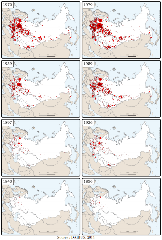
Network theory as a tool to detect multi-scale clusters
INDUSTRIAL SIMILARITY x GEOGRAPHICAL PROXIMITY
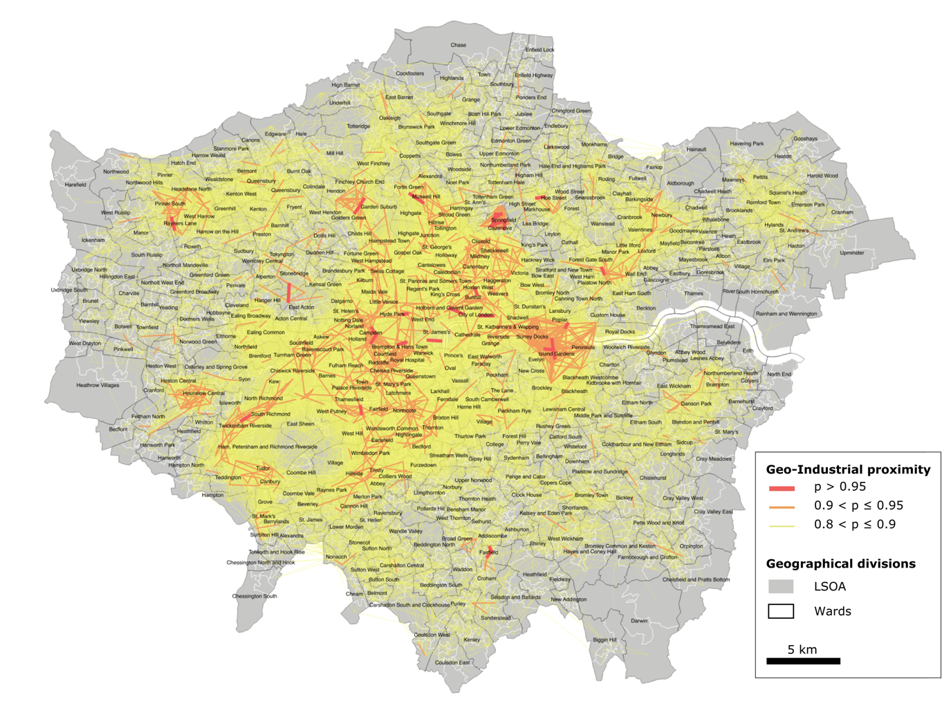
cf. Cottineau & Arcaute 2019
Source: ONS, BSD
Network theory as a tool to detect multi-scale clusters
cf. Cottineau & Arcaute 2019
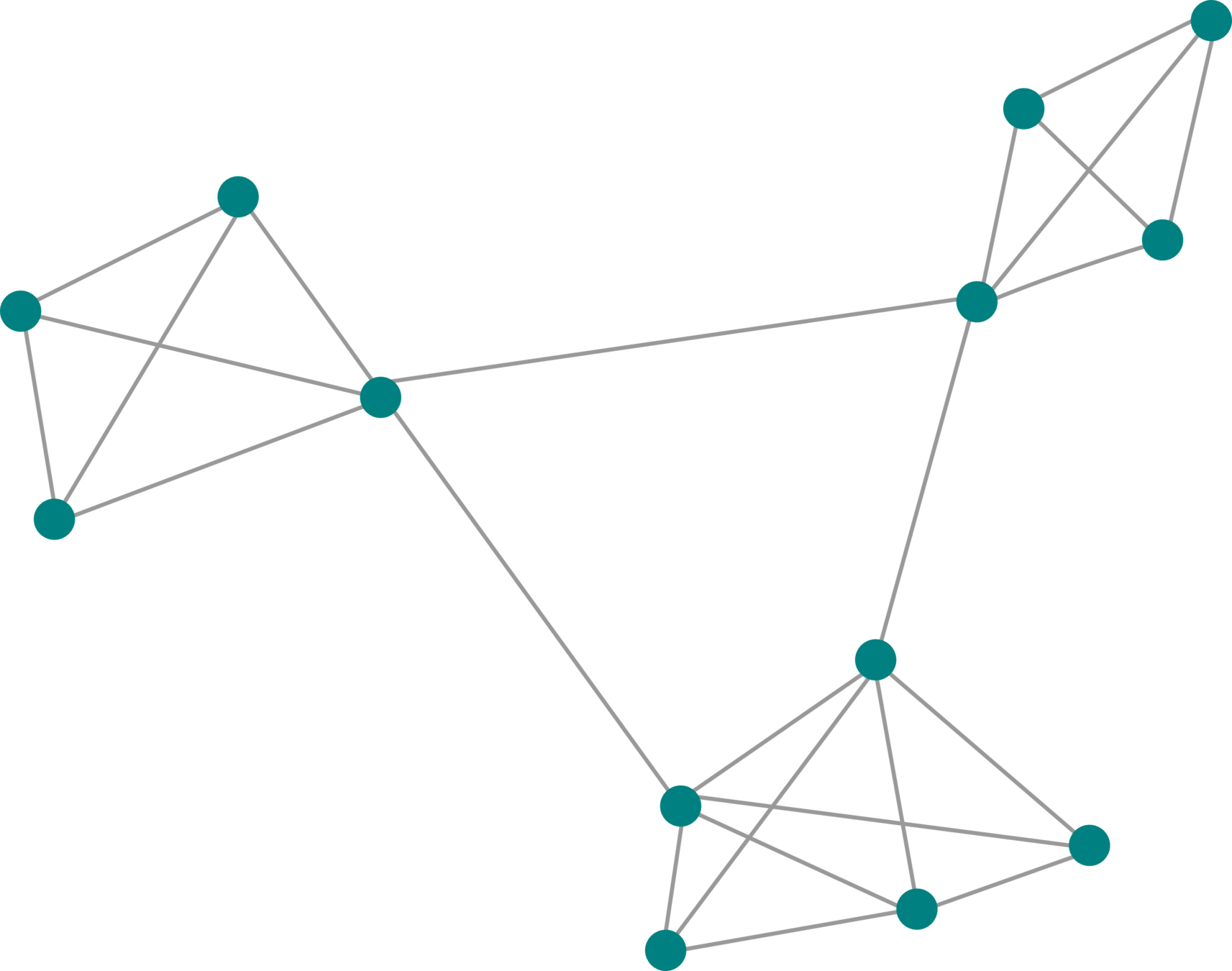
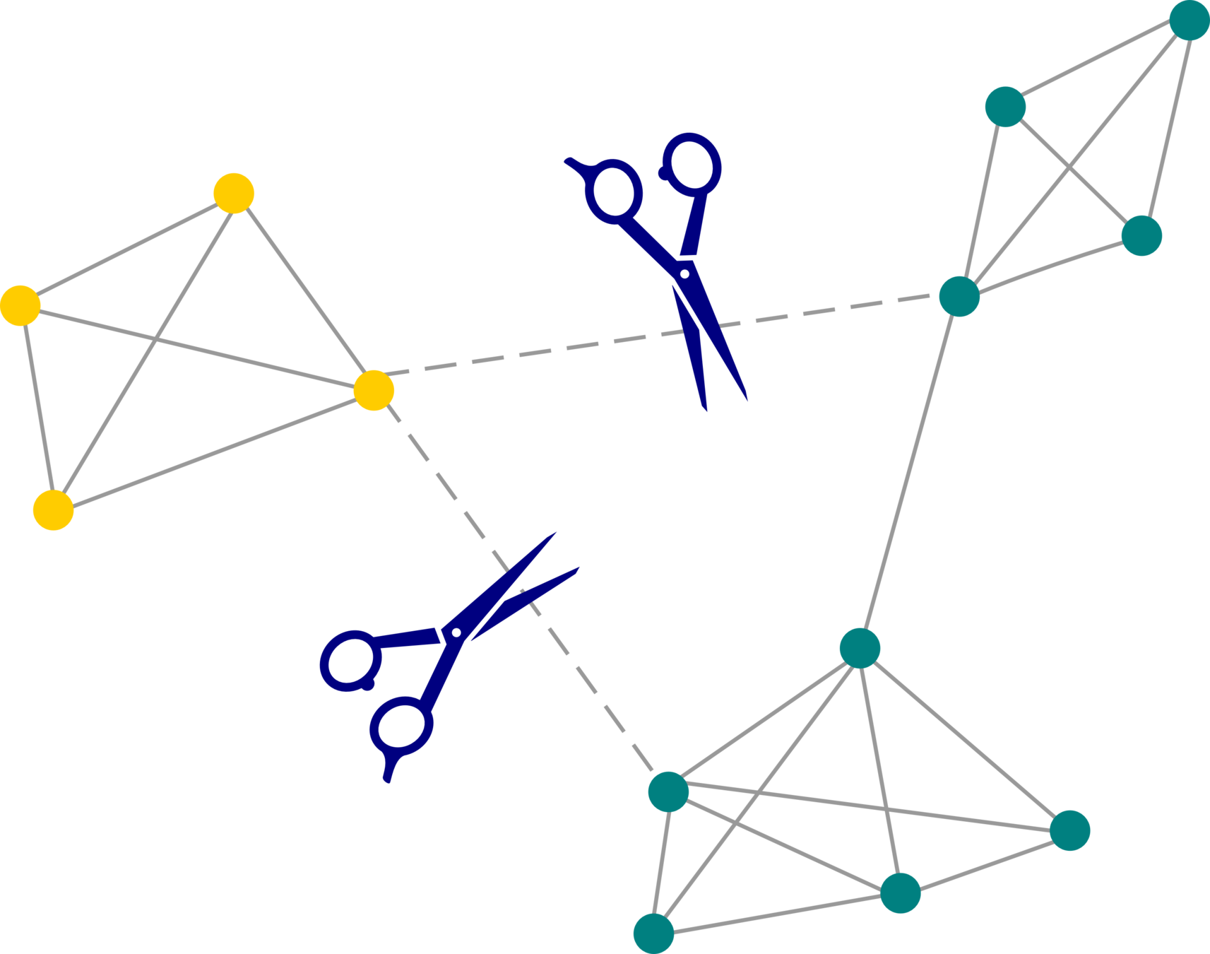
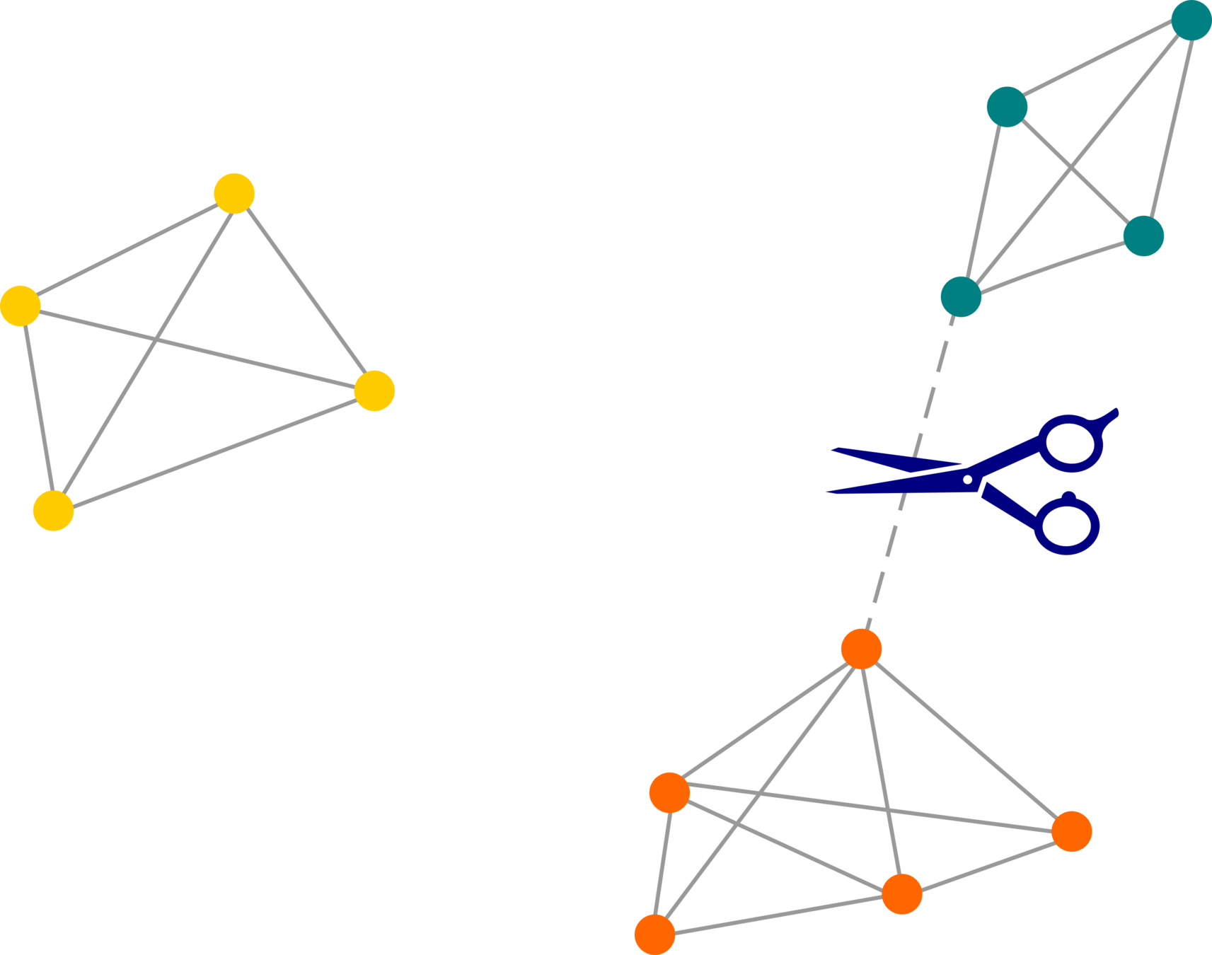
P > p1
P > p2 > p1
P > p3 > p2
Network theory as a tool to detect multi-scale clusters
cf. Cottineau & Arcaute 2019
Source: ONS, BSD
Network theory as a tool to detect multi-scale clusters
cf. Cottineau & Arcaute 2019
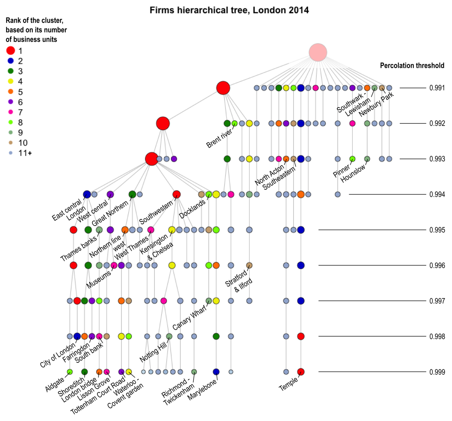
Source: ONS, BSD
Network theory as a tool to detect multi-scale clusters
cf. Cottineau & Arcaute 2019
Source: ONS, BSD
Network theory as a tool to detect multi-scale clusters
cf. Cottineau & Arcaute 2019
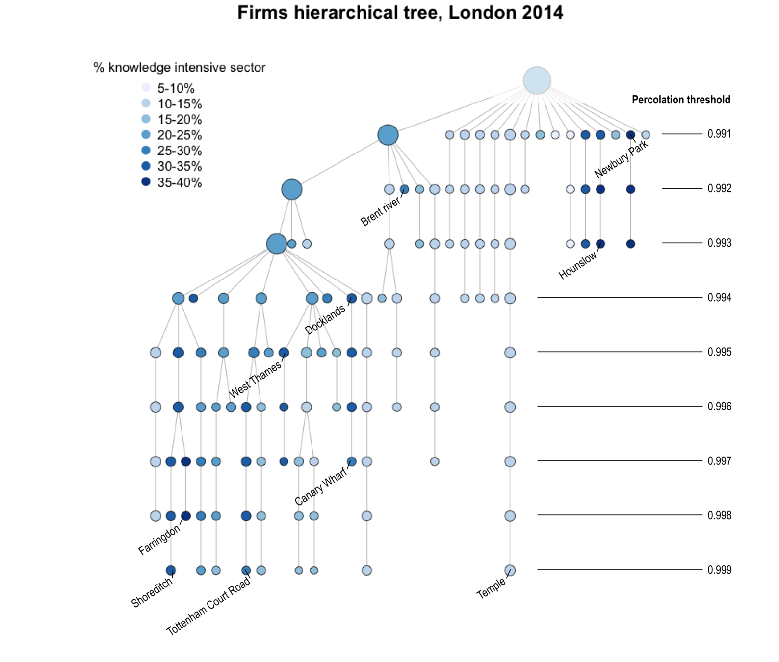
Source: ONS, BSD
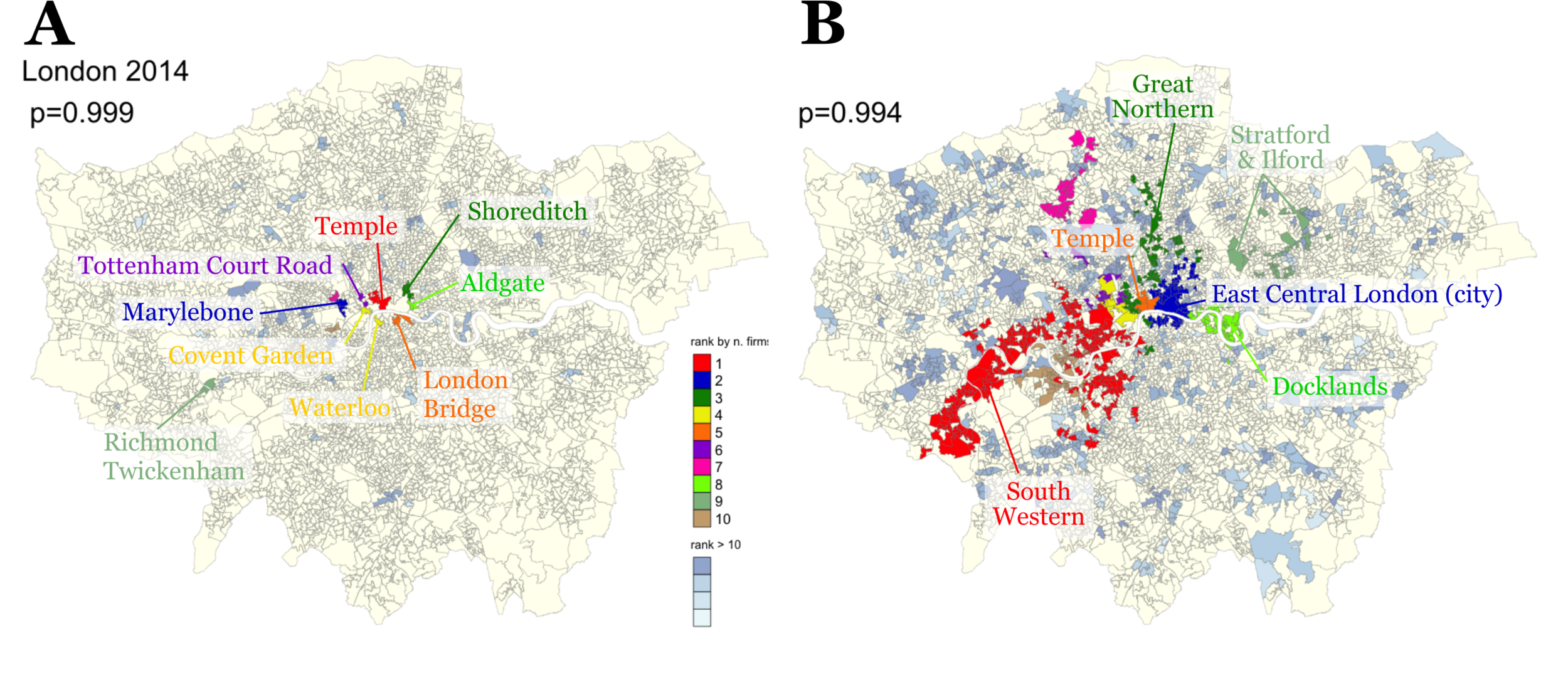
From geoindustrial clusters to segregation clusters
REPLACE FIRM COMPOSITION BY POPULATION GROUPS
Multiscale measure
Possibility to integrate time
Possibility to link mechanism scale to cluster delineation
Identification of discontinuities
Linkage between scales, from individual to national
Adaptable to individual and zonal data depending on availability
From geoindustrial clusters to segregation clusters
FIRST TESTS FOR LONDON
Using Annual Survey of Hours and Earnings
From 20,000 to 46,000 people surveyed in Greater London each year
Located at postcode level
Indication of gross pay & hours worked
+ social occupation, age, sex, etc.
Economic similarity defined as
- K-S max distance between pay distributions of small areas
- Absolute difference of Gini index
Creation of pay distribution per small areas based on London deciles
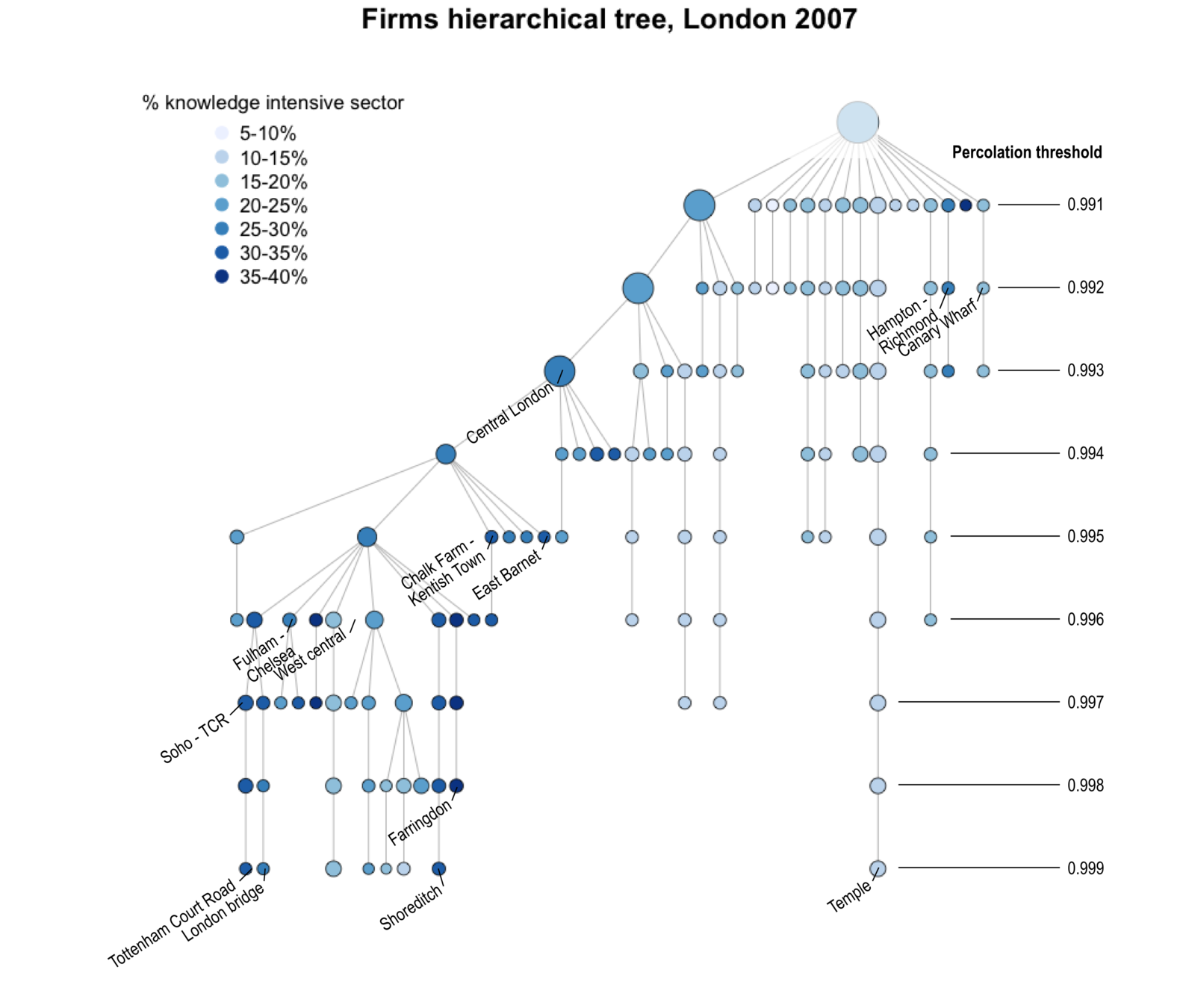
From geoindustrial clusters to segregation clusters
FIRST TESTS
FOR LONDON

Source: ONS, ASHE 2009
Acknowledging the various scales of economic inequality and segregation
Linking spatial and temporal scales in the measure and simulation of economic inequality
SUMMARY AND PERSPECTIVES
Accounting for dynamical processes
SUMMARY AND PERSPECTIVES
URBAN
SEGREGATION
ECONOMIC
INEQUALITY
Listing mechanisms with scales
Using multiscale methods
Embedding cities in continuous space
SUMMARY AND PERSPECTIVES
> Explore discontinuity in space with non-mergers of close clusters
> Use individual data (register?) to initialise models
> Extend multiscale clustering to national scale
References
Parr, J. B. (2007). Spatial definitions of the city: four perspectives. Urban Studies, 44(2), 381-392.
Rosen, K. T., & Resnick, M. (1980). The size distribution of cities: an examination of the Pareto law and primacy. Journal of urban economics, 8(2), 165-186.
Soo, K. T. (2005). Zipf's Law for cities: a cross-country investigation. Regional science and urban Economics, 35(3), 239-263.
Cottineau, C. (2017). MetaZipf. A dynamic meta-analysis of city size distributions. PloS one, 12(8), e0183919.
Arcaute, E., Hatna, E., Ferguson, P., Youn, H., Johansson, A., & Batty, M. (2015). Constructing cities, deconstructing scaling laws. Journal of The Royal Society Interface, 12(102), 20140745.
Cottineau, C., Finance, O., Hatna, E., Arcaute, E., & Batty, M. (2018). Defining urban clusters to detect agglomeration economies. Environment and Planning B: Urban Analytics and City Science, 2399808318755146.
Cottineau, C., Hatna, E., Arcaute, E., & Batty, M. (2017). Diverse cities or the systematic paradox of urban scaling laws. Computers, environment and urban systems, 63, 80-94.
Briant, A., Combes, P. P., & Lafourcade, M. (2010). Dots to boxes: Do the size and shape of spatial units jeopardize economic geography estimations?. Journal of Urban Economics, 67(3), 287-302.
Meijers, E. J., & Burger, M. J. (2017). Stretching the concept of ‘borrowed size’. Urban Studies, 54(1), 269-291.
Cottineau, C., & Vanhoof, M. (2019). Mobile phone indicators and their relation to the socioeconomic organisation of cities. ISPRS International Journal of Geo-Information, 8(1), 19.
References
Petrović, A., Manley, D., & van Ham, M. (2019). Freedom from the Tyranny of Neighbourhood: Rethinking Socio-Spatial Context Effects, Progress in Human Geography, 1-21
Cottineau, C., Reuillon, R., Chapron, P., Rey-Coyrehourcq, S., & Pumain, D. (2015). A modular modelling framework for hypotheses testing in the simulation of urbanisation. Systems, 3(4), 348-377.
Piketty, T. (2018). Capital in the 21st century. In Inequality in the 21st Century (pp. 43-48). Routledge.
Alacevich, M., & Soci, A. (2017). Inequality: A Short History. Brookings Institution Press.
Jaquet, C. (2014). Les transclasses, ou la non-reproduction. France (Presses universitaires de).
Sampson, R. J. (2012). Great American city: Chicago and the enduring neighborhood effect. University of Chicago Press.
George, P. (1981). Géographie des inégalités. FeniXX.
Raimbault, J., Cottineau, C., Texier, M. L., Néchet, F. L., & Reuillon, R. (2018). Space Matters: extending sensitivity analysis to initial spatial conditions in geosimulation models. arXiv preprint arXiv:1812.06008.
Spielman, S., & Harrison, P. (2014). The Co‐evolution of Residential Segregation and the Built Environment at the Turn of the 20th Century: AS chelling Model. Transactions in GIS, 18(1), 25-45.
Cottineau C., Arcaute E., (to be published), "The nested structure of urban business clusters", Applied Network Science. Available at https://arxiv.org/abs/1905.05106
Dank u wel!
Get in touch if you're interested.
email | clementine.cottineau@ens.fr
twitter | @ClementineCttn
gitHub | github.com/ClementineCttn
blog | unequalread.hypotheses.org
slides | slides.com/clementinecottineau/geographical-scales-of-economic-inequality
Seminar at
28th October 2019
This work contains statistical data from ONS which is Crown Copyright. The use of the ONS statistical data in this work does not imply the endorsement of the ONS in relation to the interpretation or analysis of the statistical data. This work uses research datasets which may not exactly reproduce National Statistics aggregates.
Geographical scales of economic inequality
By Clémentine Cottineau


